Daytime highs will continue to be above the seasonal average of 6°C throughout the remainder of the work week, however it will come at a cost as a series of disturbances work across the region bringing multiple rounds of wet weather.
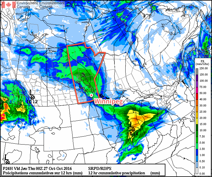
The first disturbance that will bring wet weather to Winnipeg is outside your window right now, as rain spread into the region overnight. The rain will taper off towards midday with a grand total of 5-10mm of accumulation likely for most areas.1 As the rain pushes off to the east, temperatures will climb to a high near 9°C under cloudy skies.

Tonight will bring some clearing to the Red River Valley, but the lack of any significant westerly flow to the winds will prevent us from seeing widespread elimination of the cloud, meaning skies will likely remain at least mixed over the region through the night. Temperatures will drop to a low near 4°C.
Thursday will leave the region in a slack flow with mixed to mainly cloudy skies. Temperatures will climb to a daytime high near 11°C in what will be a rather unremarkable day. The next disturbance will begin moving through the region on Thursday night, thickening up the cloud cover again as temperatures drop to a low near 6°C.
Friday is a bit of a wildcard at this point…at least for Winnipeg. A low pressure system tracking along the International Border will spread an area of rain to its north, however who exactly will see rain will be a bit of a challenged as the southern edge of the accumulations will see a rapid cutoff. Complicating things is relatively minimal model agreement:
| Model | Event Rainfall (mm) |
|---|---|
| RDPS | N/A |
| GFS | 0.5 |
| NAM | 1.9 |
| GDPS | 3.9 |
| PME | 4.0 |
| GEPS | 8.8 |
So the range in precipitation amounts goes from the GFS’ low end forecast of 0.5mm, a situation where pretty much the entire area of rain falls north of the city, up to nearly 10mm from the global ensemble prediction system. It seems likely that the bulk of the rainfall with this system will fall north of Winnipeg, with the city seeing either some brief rain or more sporadic shower activity through the day.
The temperature should reach a high near 10°C while the overnight low drops to around 5°C under cloudy skies.
Long Range
The weekend is looking dry as seasonal air returns to the region with northerly winds on Saturday and southerly winds on Sunday. The chance for rain returns to the Red River Valley on Monday.
Winnipeg’s seasonal daytime high is currently 6°C while the seasonal overnight low is -3°C.
- A few locations along the western escarpment northwestwards into Parkland Manitoba may see total amounts in the 10-15mm range. ↩

Thanks for the update. Good to see no snow in the forecast!