Severe Weather Event South of the Border: Possible AWM Chase Sat/Sun
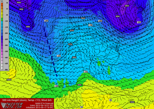
The same system that will cause Southern Manitoba to have a rainy May long weekend is expected to produce a string of severe weather days across the Central US, starting today, continuing through at least Tuesday. A negatively-tilted longwave trough approaching from the west will help to provide the necessary wind shear, lift, and instability for severe storms to develop. A broad surface low with an extending cold front from Central South Dakota through Nebraska will be in place with a warm front slicing through north-east South Dakota. Another, stronger, low pressure center will be in place in Kansas with an extending dryline all the way down to Texas. These features will offer enough lift for severe storms on Saturday. This, combined with other severe weather ingredients such as a stiff low level jet (LLJ), high amounts of instability, deep low level moisture and low cloud bases is ideal for severe weather and tornadoes. The Storm Prediction Center has issued a Moderate Risk for Nebraska and Kansas with a Slight Risk extending up to North Dakota for their 2 Day Outlook as of Friday night.
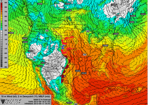
As of Friday evening these ingredients appeared to be maximized in the vicinity of north-western Kansas near the Nebraska border. Storms will not be confined to this area though, as strong to severe storms will still be possible into South Dakota and down into Oklahoma, but whether they will be tornadic or not is still to be seen.
The ingredients that will be in place tomorrow in South Dakota:
- Instability: about 2000J/Kg of MLCAPE (mixed layer)
- Surface dewpoint: 18°C
- Shear: 40 knots (0-6km shear)
- LLJ: 20 knots
- Lifting condensation levels (cloud bases): around 750m
With the LLJ being only 20 knots, an AWM Chase is still up in the air. If models tend towards a stronger LLJ, the chase will likely be on with a target somewhere in Central South Dakota.
Sunday also offers a significant severe weather threat as the trough continues its trek towards the east. Severe weather risk would extend into Southern Minnesota all the way down to Oklahoma. There is still some uncertainty about Sunday but it does look like another significant severe weather outbreak day for the Plains and Upper Mississippi Valley. Stay tuned in the comments section as the event approaches, updates will be posted.
AWM Chase is On!
Two of the AWM team members will be out chasing this setup along with a student from the University of Manitoba. You can keep up with their chase right here:
new TWTR.Widget({
version: 2,
type: ‘list’,
rpp: 30,
interval: 30000,
title: ‘May 18, 2013’,
subject: ‘AWM North Daktoa Chase’,
width: ‘auto’,
height: 500,
theme: {
shell: {
background: ‘#3c3c3c’,
color: ‘#eeeeee’
},
tweets: {
background: ‘#eeeeee’,
color: ‘#2c2c2c’,
links: ‘#489ce1’
}
},
features: {
scrollbar: true,
loop: false,
live: true,
behavior: ‘all’
}
}).render().setList(‘WeatherInThePeg’, ‘awm-team’).start();