Cold and dry weather continues through the end of the week and into the weekend, however long-range guidance continues to develop a consensus that will show a moderate-to-significant warm-up by the end of next week.
Today is bringing mainly sunny skies over southern Manitoba with highs near the –20°C mark. It will be a little breezy with northwesterly winds to 20–30km/h. Winds will taper off this evening with temperatures dropping to around –23°C. Clouds will thicken up overnight as a trough of low pressure slides into the region from the northwest.
This trough of low pressure will be the main weather story for Thursday; the first half of the day will be cloudy with some light snow before things begin to clear through the afternoon. Winds will strengthen out of the northwest behind the trough and by mid-afternoon much of the Red River Valley will see winds of 30–40km/h with gusts to 60km/h. Winds will stay breezy through Thursday night at around 30km/h as the temperature drops to around –25°C.
Friday will bring a few clouds and a high near –18°C with breezy winds to 30–40km/h once again out of the west-northwest.
Big Warm-Up Next Week?
Long-term forecast models are beginning to come into a consensus that we’ll see a fairly significant warm-up through the latter half of next week.
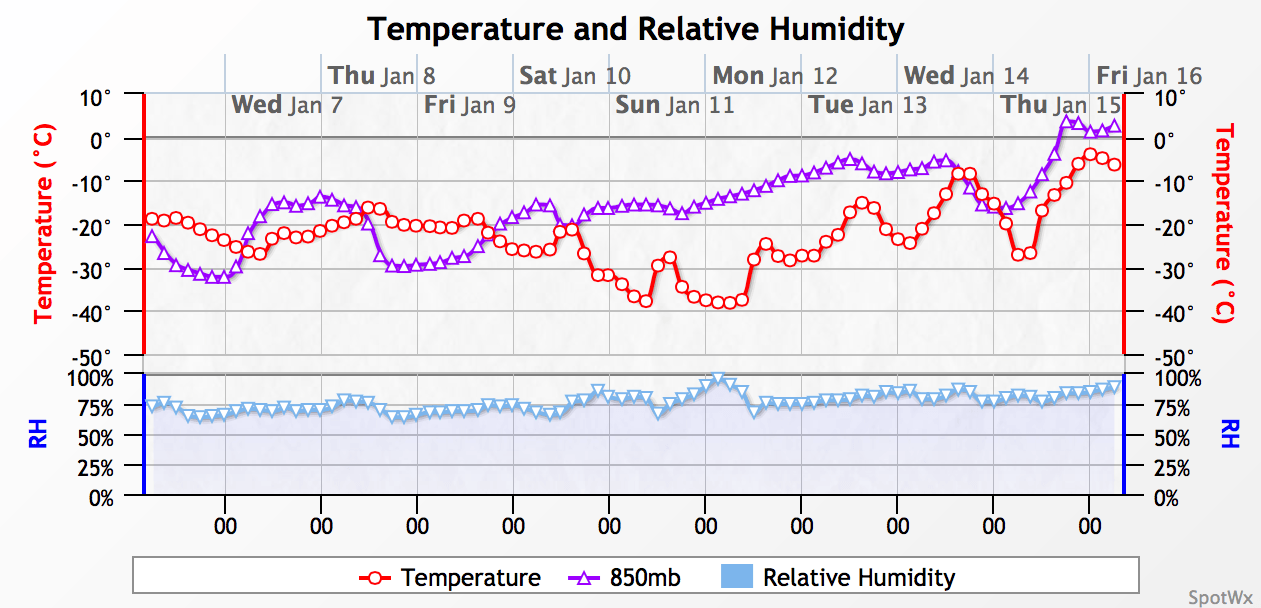
Probabilistic forecasts are all showing warmer-than-seasonal temperatures in the 8–14 day period[1], however some models are hinting that it might get significantly warmer. Shown above, the GDPS weather model is bringing 850mb temperatures near 0°C into the region through next week which allows the surface temperatures to gradually climb to around 0°C as well.
There’s a lot of danger in using a deterministic model that far into the future, though, and I’d feel a lot more comfortable with temperatures in the –10 to –5°C range by mid-week instead of promising highs near the freezing mark.
Alongside the warming trend will come a more active storm track which will bring the potential for a couple snow events across the region as well.
- Seasonal daytime highs for Winnipeg next week sit around the –12°C mark. ↩