While Southern Manitoba has seen glancing blows from true Colorado Lows a few times over the past couple years, Winnipeg is in the middle of a multi-year drought with the last direct hit from a Colorado Low in memory occurring in November 2012.[1] Responsible for some of the biggest synoptic storms[2], Colorado Lows are a major weather system that often produce pretty much everything: thunderstorms, heavy rain, light showers, overcast & drizzly conditions, freezing rain, heavy snow and/or blizzard conditions.
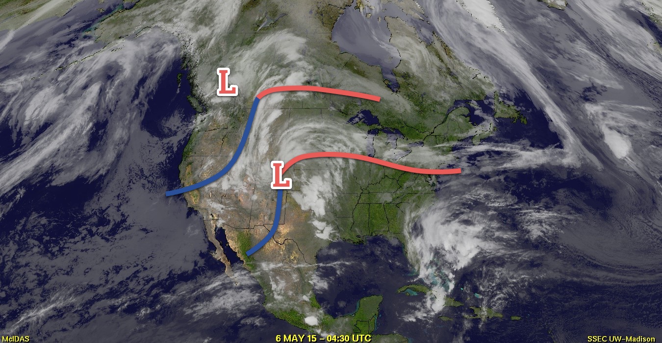
Today will see the arrival of a Colorado Low that will dominate the weather over Manitoba for the coming few days. Southern Manitoba will escape most of the nasty weather associated with this system with just rain expected – albeit a fair amount – while Northern Manitoba gets slammed with heavy snow, freezing rain and strong winds.
Wednesday
Today will be a relatively pleasant day despite the imminent arrival of the Colorado Low. While today will start off with a little bit of sunshine, high cirrus will move in through the morning with thicker cloud arriving this afternoon. Winds will be out of the south to southeast at around 30–40km/h with some gustiness on top of that. Shower activity – with the risk of thunderstorms – will work its way northwards out of the Dakotas through the day into the Red River Valley. Temperatures will be quite mild with highs around the 23–24°C mark.
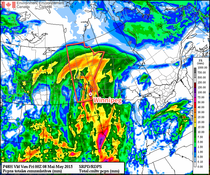
Heading into the evening, main band of showers associated with this system will spread across Southern Manitoba bringing rain with a slight chance of an embedded thundershower to the region. Rainfall amounts through the Red River Valley will likely be highly variable thanks to the convective nature of the precipitation; in general the “safe” guess at this point is somewhere in the 15–25mm range…or so. I don’t believe amounts will be much higher than that, but depending on a whole bunch of factors, amounts could end up in the 5–10mm range instead. Unfortunately, with such highly convective systems, these things are almost impossible to forecast until much closer to the event, so we’ll be providing updates in the comments below as well as on Twitter and Facebook. The showers will persist through the night as the temperature dips down to around 14 or 15°C.
Thursday
Tomorrow will be a fairly wet day with more shower activity, potentially quite heavy at times, lasting much of the day before finally beginning to taper off in the evening. Our high temperature will only be around 17°C with some light southerly winds flipping to the northwest in the afternoon to around 40km/h. Rainfall amounts, again, could be quite variable thanks to the convective nature of things and exactly how the system matures.
There are really two possible outcomes:
1. General rainfall amounts near 10mm with convective amounts once again near 20–30mm in the Red River Valley. This would assume a general “rainy” area with embedded convective storms.
2. Very little rain as energy reconsolidates around a low developing in North Dakota and precipitation pushes off to our south and east.
I don’t think Plan #2 is particularly likely, but it should be noted. Again, we’ll provide updates heading forward below in the comments as this entire system becomes a more developed.
The gusty northwesterly winds will taper off in the evening as the precipitation moves out. Expect the temperature to drop to a very chilly –2°C.
Friday
Friday will be a pretty benign day marked by temperatures well below normal for this time of year as our high struggles to climb to 8°C with an Arctic ridge building into the region. Winds will be breezy out of the northwest at around 30km/h making for a chilly day all around.
Clear skies will continue on Friday night as the temperature dips to around –3°C.
- I checked through our archives and chatted with a few other people, and that seems to be the general “last hit” agreement. Feel free to leave a comment if you can recall one more recently. ↩
- Synoptic storms are large low pressure systems that impact across hundreds to thousands of kilometres, unlike convective storms which impact small areas. ↩