Light snow will taper off and lead towards a seasonal Christmas this year with a chance of flurries, but perhaps one of the strongest shots of cold air seen this winter will move in for Boxing Day.
Light snow will persist through much of today thanks to a persistent area of snow hanging back into the Red River Valley. There will be a bit more accumulation; generally around 2-4 cm will fall today through the valley. The wind will be a bit chilly as it picks up out of the northwest to around 30 km/h with some gusts on top of that; with the fresh snow in place, it will likely be enough to produce localized areas of blowing snow and poor visibilities. With that north wind, we’ll see temperatures fall throughout the day to around -10°C by the evening hours, which will be just a couple degrees warmer than our overnight low of -12°C.
Thursday will see plenty of cloud lingering around in the Red River Valley. Temperatures will be nearly stagnant through the day, rising just a couple degrees by early in the afternoon before beginning to fall again, a casualty of the incoming Arctic air. It doesn’t look like snow will be much of an issue, though, so other than the cool temperatures, the day should actually be alright. Heading into the night, temperatures will drop to around -15°C under mostly cloudy skies.
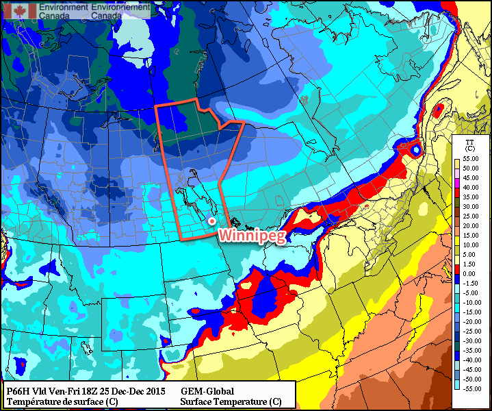
Friday, Christmas Day, will be a seasonal day thanks to a weak disturbance forecast to slip across the region, delaying the arrival of the colder Arctic air. With a daytime high of -12°C, temperatures will be nearly right on what’s seasonal for this time of year. A bit of very light snow is likely, but accumulations look to be minimal. Winds will shift around to the north and begin ushering in colder air late in the day. Expect an overnight low on Friday night dipping into the -20’s, likely around -22°C or so with clear skies beginning to develop over the region.
Long Range
The weekend will start with a miniature deep freeze, at least by the standards 2015 has set so far. Saturday will see clear skies and daytime highs struggling to climb even towards the mid-minus teens, likely ending up somewhere between -20 and -15°C. Fortunately, the cold weather will be short lived with a surge milder air returning for Sunday and returning daytime highs close to the -10°C range.
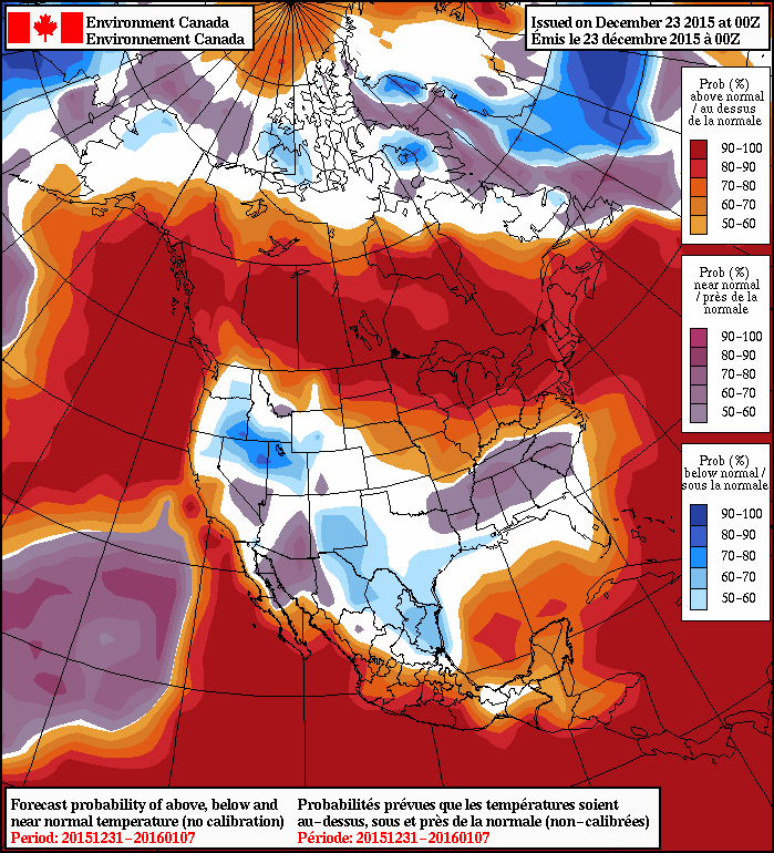
Heading into the longer-range, there’s very strong agreement that a return to significantly above normal temperatures will return to the region for the new year. The NAEFS is actually forecasting a significant stretch of daytime highs likely in the -10°C to -5°C range for the first week of January. So just get past this weekend and rest easy knowing that relative warmth is on the way!
The seasonal temperatures for Winnipeg right now are daytime highs of -12°C and overnight lows of -22°C.
With the snow tapering off, it’s time for storm-total snowfalls! Here in Glenwood, we received 12.3cm of snow through this storm, very much in line with reports of 12-15cm throughout Winnipeg. Throughout southern Manitoba, amounts ranged from 2 to 25cm with this storm. Here’s the snowfall summary issued by Environment Canada:
Weather summary
for Manitoba
issued by Environment Canada
at 10:31 a.m. CST Wednesday 23 December 2015.
==Discussion==
A low pressure system that tracked northward from the Dakotas
produced another significant snowfall to much of southern Manitoba
last night and this morning. Generally 10 to 20 cm of snow fell with
locally higher amounts near the Manitoba escarpment. Another 2 to 4
cm of snow can be expected today before the snow tapers off this
evening.
The following is a summary of weather event information received by
Environment Canada.
Summary of total snowfall amounts up to 8 AM this morning.
Darlingford 25 cm
Morden 21 cm
Altona 20 cm
Morris 17 cm
Niverville 14 cm
Schanzenfeld 14 cm
Gretna 14 cm
Portage La Prairie 13 cm
Winnipeg 12 cm
Stony Mountain 12 cm
Emerson 11 cm
Pinawa 10 cm
Steinbach 10 cm
Woodlands 10 cm
Oakbank 10 cm
Sprague 9 cm
Brandon 3 cm
Please note that this summary may contain preliminary or unofficial
information and does not constitute a complete or final report.
End/PASPC
I’ll hopefully have time tomorrow to produce a map verifying our attached forecast amounts!