Another shot of bitterly cold air is poised to crash through Manitoba this weekend with daytime highs plummeting back into the -20’s and overnight lows dipping close to -30°C.
The cold snap this weekend is looking slightly different from earlier in the week and now comes with some good news, some bad news, and a bit more uncertainty. The overall pattern has shifted further west, with the core of the coldest air now forecast to slump southwards over the Saskatchewan/Manitoba border instead of the Red River Valley. This will shift the coldest temperatures westwards, which results in the good news for Winnipeg: it likely won’t be quite as cold as it looked earlier in the week, but just by a couple degrees. The bad news, however, is that there will be a bit more wind throughout the Red River Valley as the light winds in the centre of the ridge shift west with the coldest air.
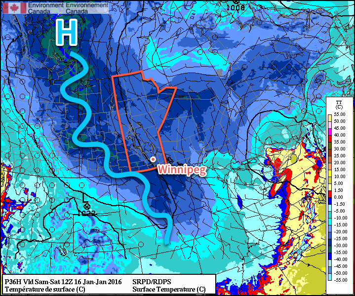
The cold air begins working in today; temperatures will climb to around -19°C today for the daytime high, and then top out between -23 and -21°C on Saturday and Sunday. Overnight lows over the coming days will likely be around -28 or -29°C for the coming 3 nights, depending on "the uncertainty."
The complicating factor with the ridge of high pressure pushing further west will be cloud cover. Two aspects complicate the fair sky forecast:
- Uncertainty in how much cloud cover will remain on the east side of the ridge. Many of the Arctic ridges this winter have been "dirty ridges," that is, they are "polluted" by significant amounts of low-level cloud. There are some indications that this may be the case with this next system, but to a much lesser extent compared to others this winter based on satellite imagery of upstream conditions.
- Complications with an inverted trough rotating through Central Manitoba. While much of the province will be under the influence of the Arctic ridge, several forecasts show a weak inverted trough associated with a system rotating through Ontario digging into the ridge through Central Manitoba. This feature could produce more cloud that would gradually slump southwards into the Red River Valley.
The biggest uncertainty with cloud cover is Saturday. My best guess at this point is that we’ll see a bit of cloud, however it will overall be a mixed-sky to sunny day. There is an off-chance, though, that we end up mainly cloudy. Cloud cover can marginally impact the daytime high (likely increasing it by around 2°C), and substantially impact overnight lows (keeping them significantly warmer than in clear skies).
That said, with winds likely between 10-20 km/h at night, wind chill values in the -35 to -40 range will be widespread over Southern Manitoba over the coming nights, with -40 or colder wind chills quite likely over southwestern Manitoba. Here in the Red River Valley, -40 wind chills seem unlikely, but could be seen if temperatures get a couple degrees colder than forecast at night or the winds are a tad stronger. Environment Canada issues extreme cold warnings when the wind chill *or* temperature is expected to drop below -40.
Sunday has more confidence in seeing mainly sunny skies.
Long-Range Outlook: Hints of Warming
The first half of the coming week still looks quite cold with daytime highs near -20°C and overnight lows in the -25 to -30°C range. By mid-week, however, it looks like a big change will be on the doorstep.

Current long-range forecast models are beginning to show with higher confidence that the polar vortex will finally be displaced allowing a milder zonal flow to develop. While it doesn’t look like a huge surge of warm air, seasonal to slightly above seasonal temperatures by the end of the week look fairly reasonable.
Right now, the average daytime high is -13°C and the average overnight low is -24°C.