Mild Monday Followed by A Cold Front & Chance of Showers

Mild weather returns to Winnipeg and the Red River Valley today thanks to a warm front that moved through the region overnight. It will be short-lived, however, as a cold front sweeps through on Monday night, bringing with it a chance of showers and a return to below-seasonal temperatures.

Today will be a very pleasant day across the Red River Valley as a sunny start to the day sends temperatures climbing towards a high near 27°C. A cold front slowly pushing southwards will start spreading cloud into the region from the north for mixed skies this afternoon and then clouding over this evening. Winds will pick up out of the west around 20 km/h.

Tonight will bring a chance of showers with the risk of isolated thunderstorms to Winnipeg & area as temperatures dip to a low near 14 or 15°C.

A cold front will be slumping southwards across the Prairies this afternoon.

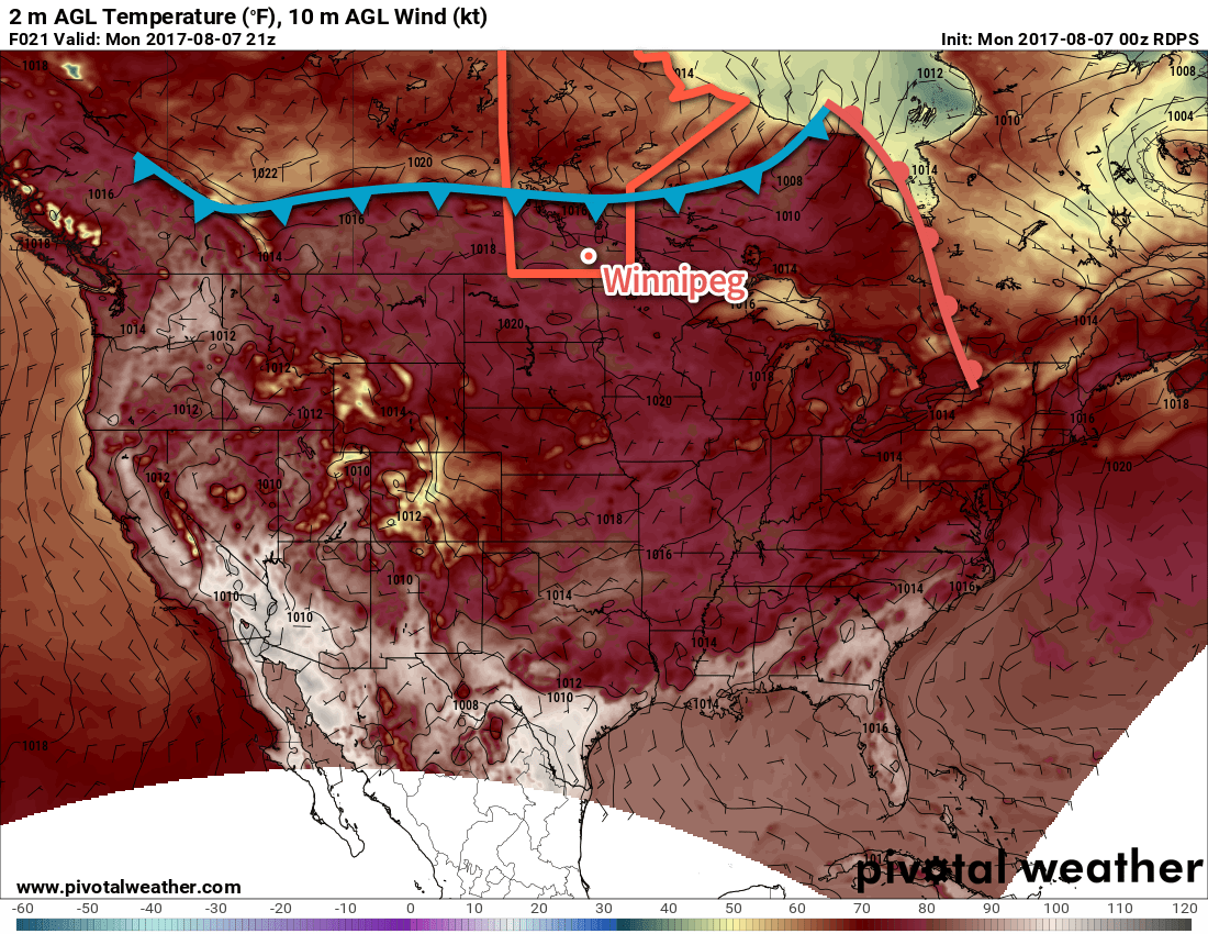
Tuesday will bring mixed to cloudy skies to the region as the cold front swings through, with a continued low chance of showers. Temperatures will be much cooler with a high of just near 22°C as winds shift to northerly at 10-20 km/h. Temperatures will then drop towards a low near 12°C under cloudy skies on Tuesday night with a continued low chance of showers.

Things will finally clear out on Wednesday as the front pushes off to the southeast. Expect temperatures to reach a high near 24°C with a low near 12°C on Wednesday night.

Long Range

It appears that things will settle down again with near-seasonal temperatures for the remainder of the week into the weekend as a very broad area of high pressure moves through the Prairies.

Winnipeg’s seasonal daytime high is currently 26°C while the seasonal overnight low is 13°C.

Slightly Cooler Than Seasonal Weather Continues

Although daytime highs will continue at slightly below-seasonal values in Winnipeg over the coming days, it will remain quite pleasant as the region still sees plenty of sunshine and light winds.

The weather over the next few days will be quite consistent as the overall pattern remains unchanged with the jet stream — and thus the storm track — diving southwards through Saskatchewan and into the central United States. The result is a persistent weak northwest to northerly flow over the region that will keep daytime highs slightly below-normal but bring pleasant summer days.

The jet stream will continue to dive southwards across the Western Prairies into the northern United States, keeping temperatures slightly cooler than normal across Southern Manitoba.

All the way through Sunday, daytime highs will sit around the 24°C mark with overnight lows between 11-13°C. Will be northwest to north at 10-20 km/h each day, and ease to west-northwest at 0-10 km/h at night. Each day should bring sunny skies in the morning, with a few clouds to partly cloudy skies in the afternoon. While rain in the Red River Valley is unlikely over the next couple days, an isolated shower or thundershower can’t be ruled out.1 And that’s pretty much it; overall there are some great days ahead!

Long Range

The nice weather continues Monday, but early indications are that a disturbance will roll across Southern Manitoba on Tuesday/Wednesday, potentially bringing some rainy weather with it. Behind that, it appears that the region will see more of the same: slightly below-seasonal highs and pleasant conditions.

Winnipeg’s seasonal daytime high is currently 26°C while the seasonal overnight low is 13°C.

  1. Any thundershowers that develop will not be severe.

Cooler Weather Arrives

A big change is on the way for Winnipeg and the Red River Valley; after a stretch of hot and humid weather, the jet stream is plunging southwards and will spread significantly cooler conditions across the southern Prairies.

Today’s weather will be dominated by an upper-level low tracking into North Dakota, shunting the jet stream further south and bringing cooler air into the region. Here in Winnipeg, temperatures will climb to around 21°C this afternoon — some 5°C below normal — with northerly winds at around 15-20 km/h. We may see a few showers in the morning, but most of the day should be cloudy with no rain. Skies will clear out late tonight into the early morning hours of Thursday as temperatures dip to a low near 11°C.

This height anomaly map of the upper atmosphere shows how the jet stream will dive southwards, bringing cooler temperatures to southern Manitoba.

Thursday will bring clearing skies as a broad ridge of high pressure builds into the region. Winds will remain light, and with a bit of sunshine highs should be a little higher than Wednesday at around 24°C. There will be a very slight chance of an isolated shower developing along lake-breeze boundaries in the Interlake and drifting south towards Winnipeg in the late-afternoon, but that the chance is low. Skies will be clear Thursday night with a low near 11 or 12°C once again.

Friday will be more of the same; light northwesterly winds under partly cloudy skies with a high near 24°C. Temperatures will dip down to a low near 13°C on Friday night.

Long Range

Saturday will continue the cooler conditions with a high in the low 20’s, but a passing disturbance will bring a slight chance of some scattered showers or thunderstorms. The remainder of the weekend into next week will bring seasonal to slightly below-seasonal temperatures with mixed skies and occasional chances for showers.

Winnipeg’s seasonal daytime high is currently 26°C while the seasonal overnight low is 13°C.