Weather Forecasts, Facts and News for Winnipeg & Southern Manitoba
Author: Brad
Brad lives in Winnipeg with his wife and two children and is the founder of A Weather Moment. He has loved weather from a very young age and has followed that passion through his life so far. He received a B.Sc. in Earth Sciences with Specialization in Atmospheric Sciences and is currently employed in the field of meteorology. You can find the author as WeatherInThePeg on Mastodon.
A pleasant and dry Canada Day is on tap for Southern Manitoba thanks to a ridge of high pressure over the region that will bring sunshine to most regions. Heading into the weekend, slightly warmer weather will bring with it more unsettled weather.
Southern Manitoba is set for a beautiful Canada Day as temperatures climb into the low 20's with mainly sunny skies and light winds. Some cloud cover will begin pushing into the region late this afternoon, likely bringing partly cloudy to mixed skies by midnight. The overnight low will dip down to near 12°C.
Saturday will bring mainly cloudy skies–although a sunny break here or there is possible—and just a very slight chance for some showers here in Winnipeg. A disturbance moving through the southwestern portion of the province will spread more organized shower activity that will pass through the southwestern Red River Valley, but likely remain south of Winnipeg. Temperatures will once again climb to around 23°C, but the wind will be a bit breezier at 20-30 km/h out of the southeast.
Cloudy skies will continue on Saturday night with a chance of showers in Winnipeg & the Red River Valley. Temperatures will drop to around 15°C for the overnight low with a continued chance of showers through the region.
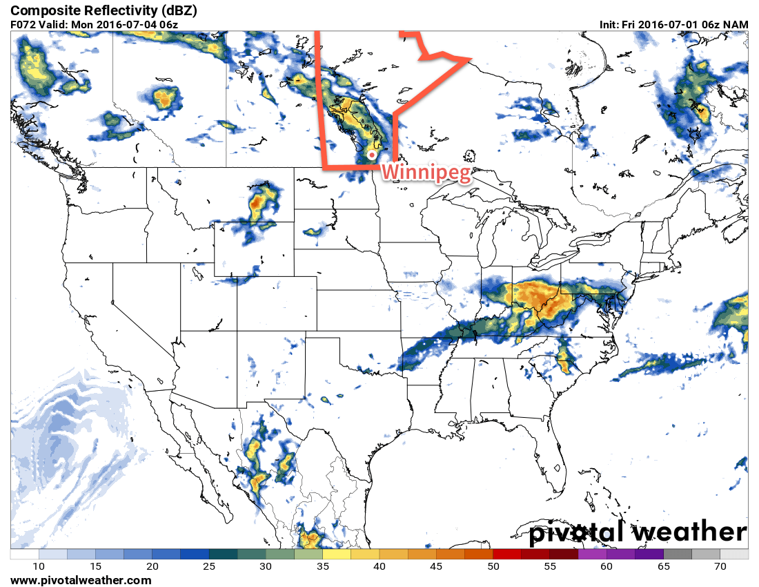
The NAM simulated RADAR imagery shows a band of showers or thunderstorms moving through Winnipeg on Sunday evening.
Sunday will be the warmest and most unsettled day of the weekend. Temperatures will climb to a high near 25°C under mostly cloudy skies. There will be a chance of showers for much of the day, but as a trough passes through in the afternoon the risk for thunderstorms will be added into the mix. At this point, there doesn't appear to be a severe threat with the storms, but we'll keep an eye on the situation through the weekend. Winds will once again be southeasterly at 20-30 km/h. Expect a mild low on Sunday night near 17°C.
Long Range
Looking into next week, conditions look fairly warm with daytime highs in the upper 20's and increasing humidity as dew points climb into the upper teens. Early indications are that there will be chances for rain or thunderstorms every day through the first half of the week, with a slightly drier and cooler pattern returning for the second half of the week.
Winnipeg’s seasonal daytime high is currently 25°C while the seasonal overnight low is 13°C.
Southern Manitoba will see one more day of showers and thunderstorms before a calmer, drier pattern moves in for the remainder of the work week.
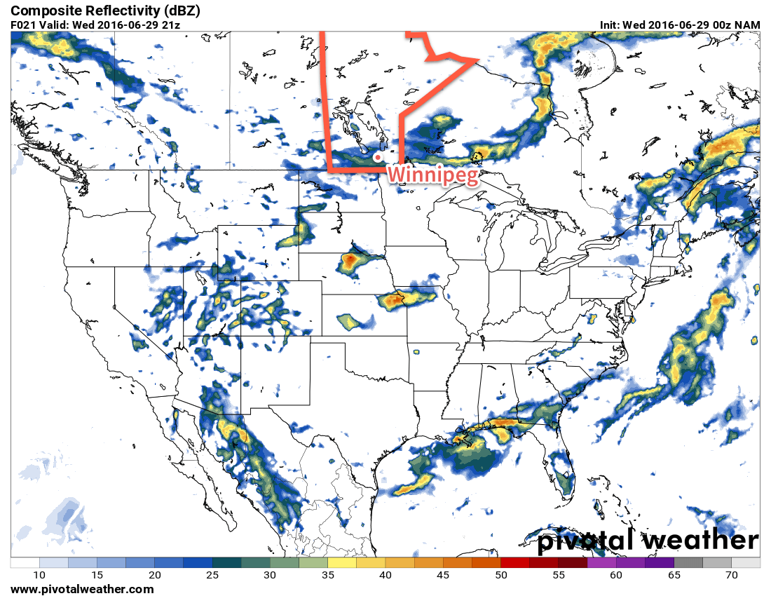
Today will bring another round of showers and thunderstorms to southern Manitoba as a cold front sweeps through the region. Under mixed skies, showers will develop through the morning, spreading southwards from the Parkland & Interlake regions into the Trans-Canada corridor and areas south through the afternoon. With MLCAPE values of 750-1250 J/kg and only around 25kt of bulk shear, the threat for severe thunderstorms will be minimal, although a quick pulse thunderstorm that quickly produces large hail and then falls apart isn't out of the question.
Temperatures will climb to near 25°C before cooling off as the cold front swings through in the afternoon. Winds will be relatively light, but we may get some slightly breezier conditions with winds out of the north to 20-30km/h behind the cold front. Skies will clear this evening and temperatures will dip down to a low near 11°C overnight.
This simulated RADAR image from the NAM shows the showers expected over Southern Manitoba this afternoon.
Thursday will see a ridge of high pressure moving into the province, which will bring mainly sunny skies, breezy winds near 30km/h out of the north and a high near just 19°C. Expect an overnight low near 8°C on Thursday night with light winds.
As the ridge of high pressure moves east of the Red River Valley on Friday, winds will gradually shift out of the south and slightly warmer air will move into the region, pushing daytime highs in Winnipeg to near 22°C with a few afternoon clouds.
Long Range
The dry weather won't be long to stay as things turn more unsettled on the weekend. A pattern shift back towards a more active storm track that brings the chance for rain or thunderstorms. Saturday will likely be dry, but the chance for rain and thunderstorms appears to return on Sunday and then persist through much of next week as a very unsettled pattern takes hold.
Heat & humidity will begin moving into the region today as a breezy southerly wind develops over the province, tapping into a much warmer air mass over the Northern Plains of the United States.
A potent low pressure complex developing over the western Prairies & Northern Plains will bring a thunderstorm threat back to Southern Manitoba today with the southwestern corner of the province under the threat for thunderstorms—potentially severe—this afternoon and this evening, while the Red River Valley and southeastern Manitoba seeing the threat move in this evening and into Saturday morning.
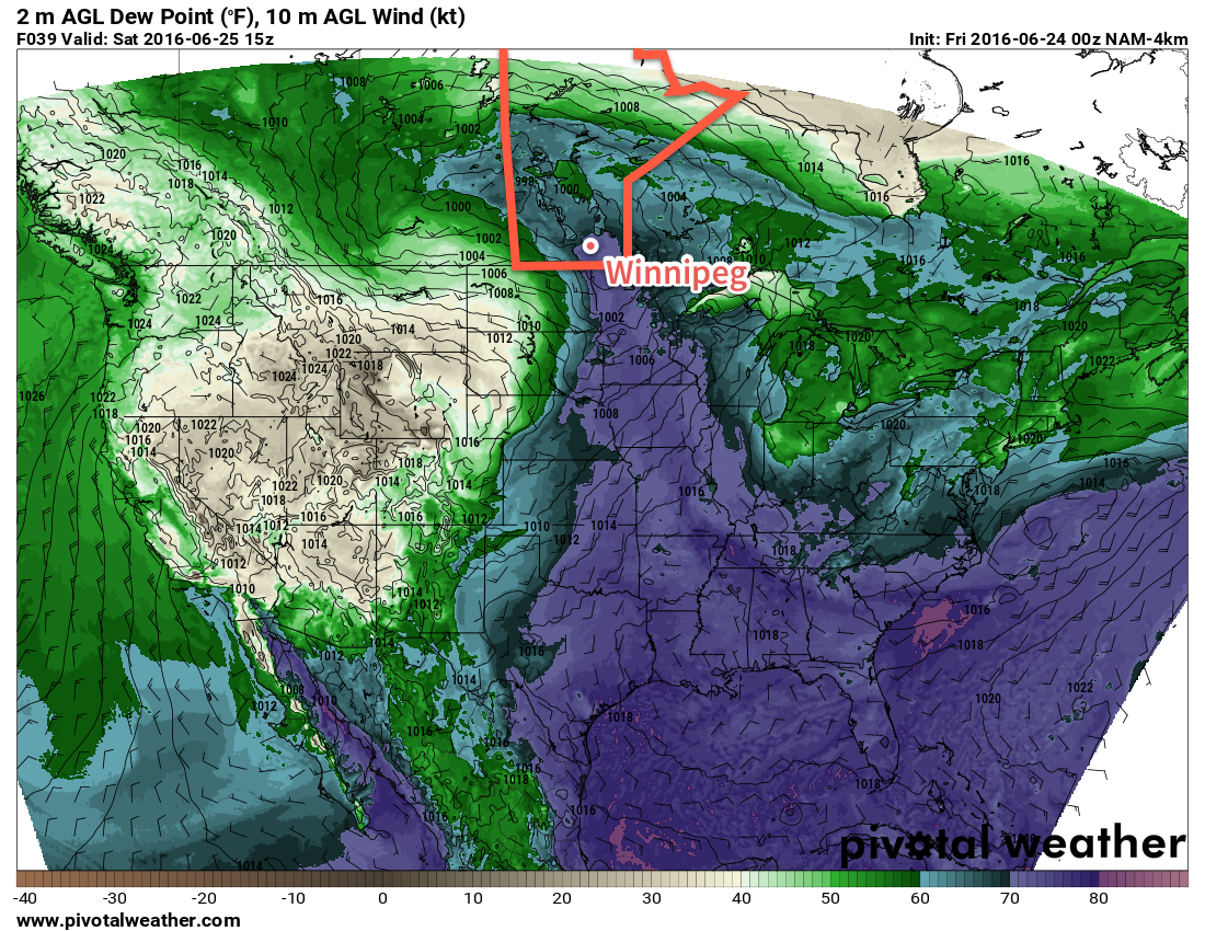
Before that, though, Winnipeg & the Red River Valley will have a fairly nice day ahead. Temperatures will soar through the morning, reaching within a degree or two of today’s high temperature of 28°C by lunch. Skies will be mixed today with cloudier conditions developing in the afternoon. Southerly winds to 30-40km/h will pick up through the day across much of Southern Manitoba, drawing moisture from the United States northwards into the province. By late afternoon, dew point values in the Red River Valley will climb to the 16-18°C range1 while in the southwest corner of the province, dew point values may reach the 20°C mark, making for very humid feeling conditions.
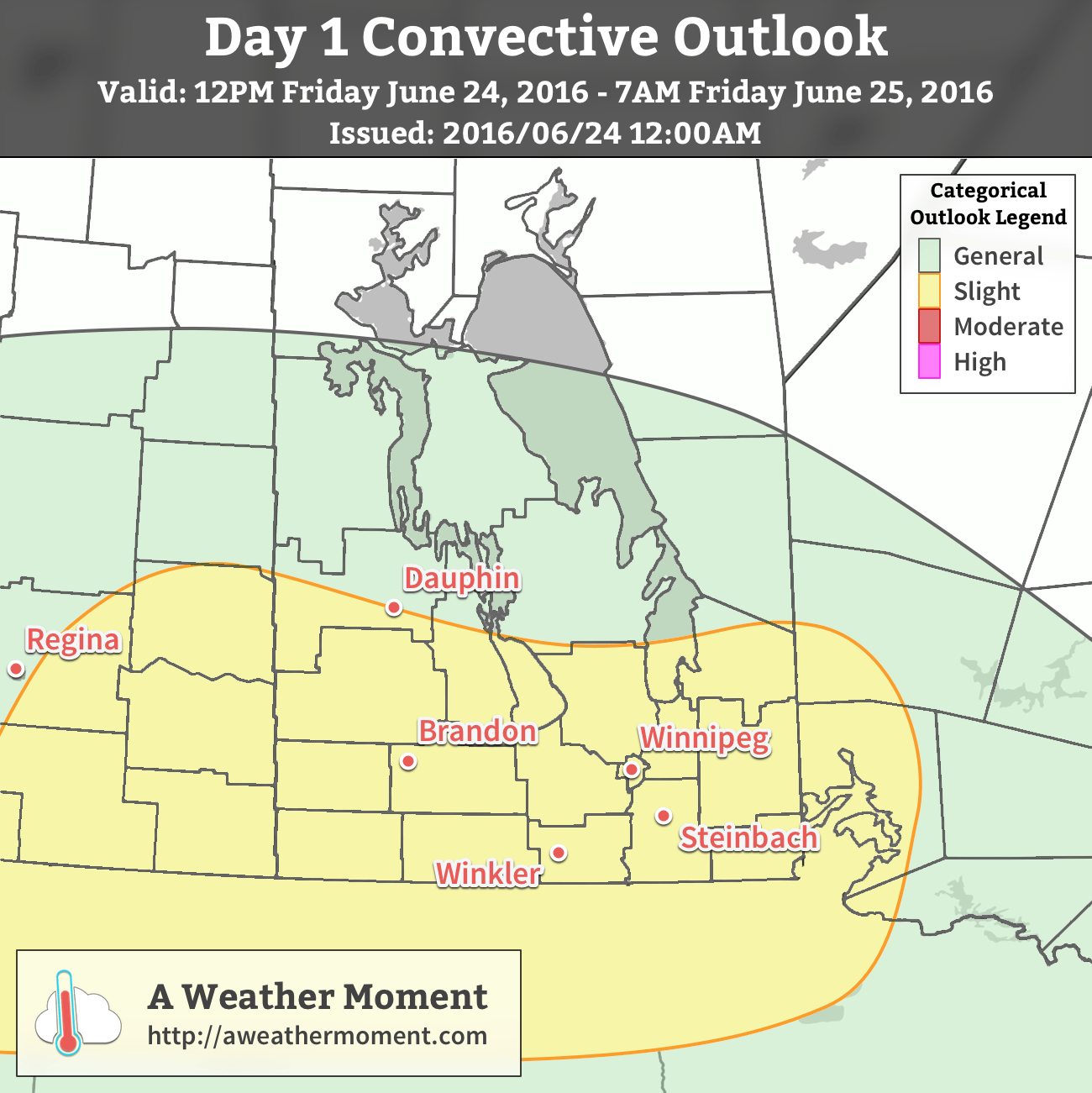
AWM Convective Outlook for June 24/25, 2016As the afternoon wears on, a leading shortwave lifting out of Montana will destabilize conditions over southern Saskatchewan and southwestern Manitoba, bringing a threat of thunderstorms to the region. There’s a slight chance that some of these thunderstorms may become severe. The threats from these storms will be:
Rainfall: Precipitable water values of 35-45 mm combined with storm motions of 20-30km/h will produce very intense rainfall, but the storms will be moving quickly enough that the overall rainfall accumulations will be limited.
Hail: With MLCAPE values in the 1500-2500 J/kg range and ample shear present, storms will likely take the form of discrete supercells early in their life cycle. These storms will be capable of producing large, damaging hail.
Wind: Overall, wind won’t be a widespread threat with these storms, but isolated damaging wind gusts are possible.
Tornadoes: The supercell thunderstorms in southeastern Saskatchewan and southwestern Manitoba will be in environments with very strong directional shear. A small chance of a tornado or two exists with these storms.
As we move into the evening, scattered showers or thunderstorms are possible over the Red River Valley while the thunderstorms closer to the SK/MB border continue onwards and grow into a larger complex of thunderstorms that will push eastwards overnight. Instability actually increases overnight as moisture continues to be pumped northwards along the low-level jet ahead of the incoming shortwave. As a result, a large area of rain and thunderstorms will likely progress eastwards overnight, reaching the Red River Valley between 3 and 6AM. These thunderstorms will present a slight risk of severe weather with primary threats of rain and large hail, with a secondary threat of damaging wind gusts.
Worth noting: if the western shortwave offering support to this system ends up slowing down, the overnight thunderstorm activity may diminish over southwestern Manitoba.
Temperatures will remain very warm on Friday night with overnight lows near 20°C in the Red River Valley.
Saturday: Muggy with Continued Thunderstorm Threat
Saturday will start with whatever convection moving through on Friday night exiting the region, and we’ll be left with very humid conditions with dew point values likely climbing to 20-21°C. Temperatures will climb towards the mid-20’s through the morning under fairly cloudy skies, but conditions will undergo a fairly significant change midday as a cold front sweeps through. The passage of this front will bring another threat of showers and thunderstorms to the region and with MLCAPE values near 1500-2000 J/kg and ample shear, these will also have bring the threat of severe weather with rainfall, winds and hail a concern.
High dewpoint values over 20°C will be in place on Saturday morning in the Red River Valley.Once the front passes, gusty westerly winds will usher in drier air as dew point values plummet into the single digits, bringing relief from the humidity. Skies will begin clearing as well, likely providing some afternoon/evening sunshine. Temperatures will likely top out at only 24 or 25°C, though, and a cooler night will be ahead with lows near 15°C.
Dreary End to the Weekend
Saturday night’s clear skies will be replaced by cloud on Sunday as the main upper-level low of this whole weather system moves through the region. It will bring showers to much of Southern Manitoba with most of the activity through the morning hours and then tapering off through the afternoon. Temperatures will be much cooler with a high near 17 or 18°C and strong northwesterly winds of 40 gusting 60 km/h picking up by the end of the morning.
The winds will taper off overnight as the valley heads to a low near 11°C.
Winnipeg’s seasonal daytime high is currently 24°C while the seasonal overnight low is 12°C.
At a dew point of 16-18°C, it begins to feel mildly muggy. ↩
A weakening disturbance will push through the province today, bringing some rain to the region. As it clears out, the heat and humidity will build back in for week's end sending daytime highs back towards the 30°C mark.
Today will see Winnipeg stuck under overcast skies as a disturbance rolls through the region, bringing some showers to the region. The best chance for precipitation will begin mid- to late-morning through the early afternoon, with diminishing chances later in the afternoon as the system moves out of the region. The cloud cover and shower activity will keep things a bit cooler with daytime highs near 21°C.
Skies will clear in the evening as the disturbance departs the region and temperatures will fall to a low near 12°C. Thursday will be a beautiful sunny day across the Red River Valley with a high near 24°C and light winds. Temperatures will dip to around 14°C on Saturday night with just a few clouds.
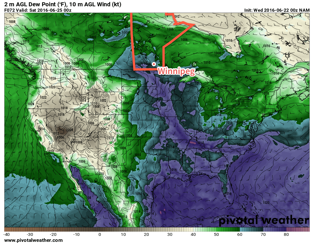
A plume of higher dewpoints, shown by the blue and purple colours, is forecast to move into southern Mantioba on Friday. A weakening disturbance will push through the province today, bringing some rain to the region. As it clears out, the heat and humidity will build back in for week’s end sending daytime highs back towards the 30°C mark.
Friday will see a return of the heat and humidity as a southerly flow re-develops over the Red River Valley. Winds will strengthen to around 30 km/h out of the south ahead of a major developing weather system in the western Prairies. Temperatures will climb to the upper 20's in the afternoon with a few clouds moving into the image. Perhaps more notably will be the humidity, which will surface through the day after northwards transport on Thursday night. From a relatively comfortable dewpoint of 12-13°C in the morning, by the end of the day the dewpoint will climb into the 18-20°C range, making for quite a muggy afternoon.
Heading into Friday evening, more cloud will move into the Red River Valley with a risk of showers or thunderstorms. It's early at this point, but there may be a slight risk of severe thunderstorms throughout the Red River Valley, including Winnipeg, on Friday evening.
Long Range
Saturday will be a warm and very humid day that will likely bring mixed skies and the risk of thunderstorms. Sunday looks to be much cooler with more comfortable humidity with a continued chance of showers or thundershowers as a large upper low moves over the province.
Winnipeg’s seasonal daytime high is currently 24°C while the seasonal overnight low is 12°C.