Spring Soaker On Tap for Southern Manitoba

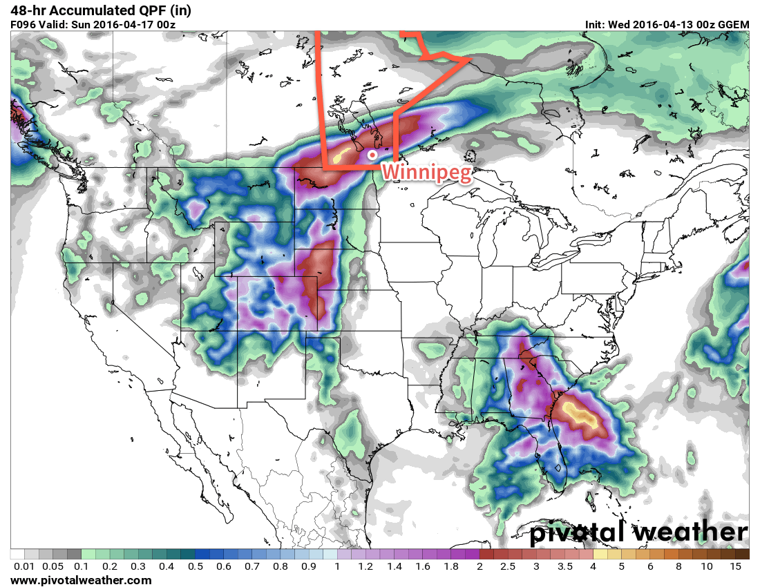
The end of week in Winnipeg will be wet as a complex series of disturbances bring several waves of precipitation to the region. Storm-total rainfall amounts of 25-75mm are possible with this system, however the amount any one place receives will be highly dependent on the exact location these features line up, which at this point, is quite uncertain.

Rainfall

A few showers or thunderstorms are possible tonight as a mid-level warm front pushes northwards through North Dakota, aided by a 45kt low-level jet. The chance for rain over the Red River Valley will be mainly before 3AM, with the bulk of any shower activity moving northwards into the Interlake.

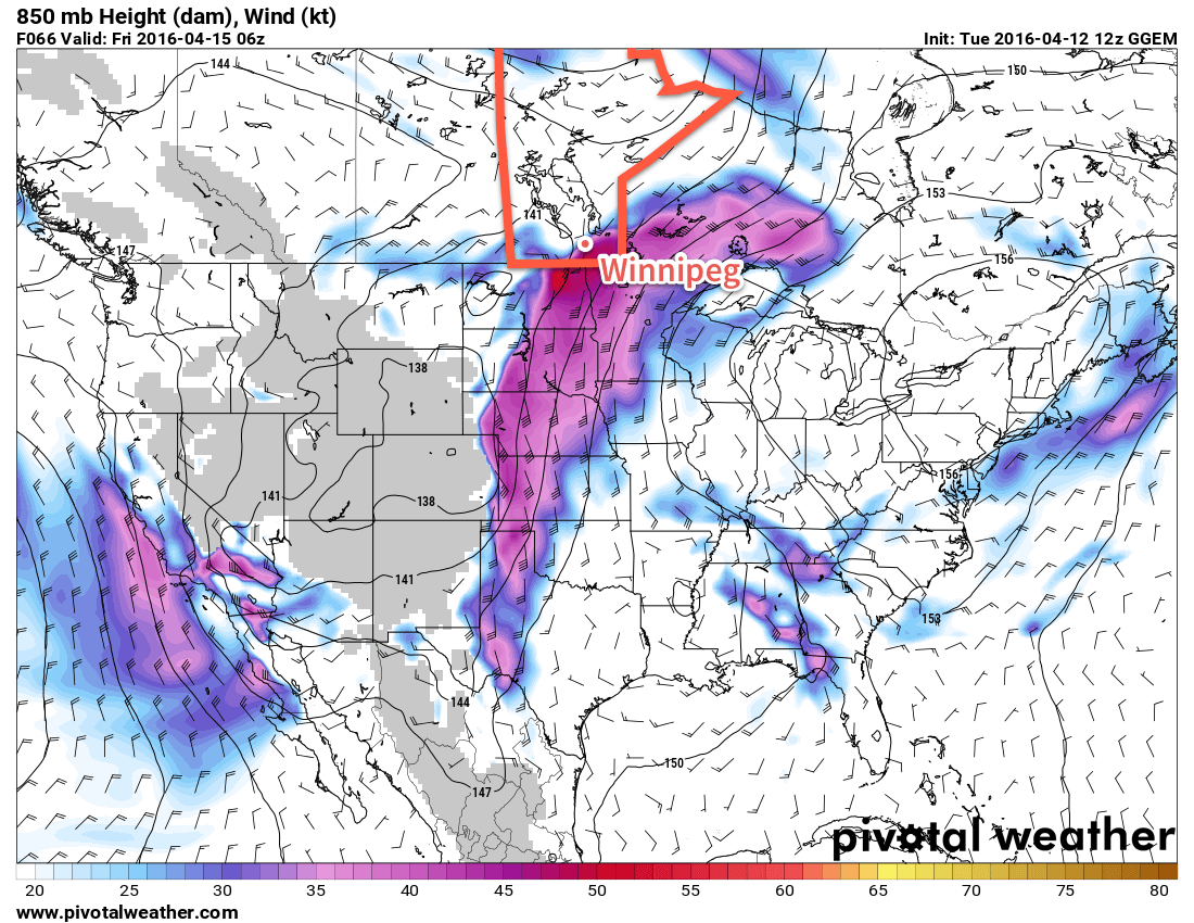
Friday will be a wet day over most of Southern Manitoba as a broad area of rain spreads across the Province along the northern edge of a low pressure system tracking through North Dakota into the Red River Valley and areas east. The main area of precipitation will blossom tonight in eastern Montana and then spread east-northeastwards into southwestern Manitoba near midnight, through the Interlake overnight, and then into the Red River Valley proper early Friday morning.

The rain will taper off through the afternoon over the southwestern portion of the province, and in the late afternoon and evening through the Red River Valley. By the time this area of rain tapers off, general amounts will be 10-30mm over southwestern Manitoba and between 5-20mm over much of the Red River Valley & Interlake.[1]

For the southwestern portion of the province, this will mark the end of the main event. Further east here in Winnipeg and the Red River Valley, things become more complicated. After a brief break on Friday evening, rainfall will re-develop on Friday night along a deformation zone[2] ahead of another disturbance pushing northwards out of the central Plains of the United states. The deformation zone will lie along a line approximately NNE-SSE through the Red River Valley & this will result in a fairly persistent band of rain that abruptly tapers off to the west of this feature.

NAM 24hr. QPF valid 06Z Saturday April 16, 2016
Here’s one shot in the dark at rainfall totals for Friday (from the 00Z April 15, 2016 NAM run).

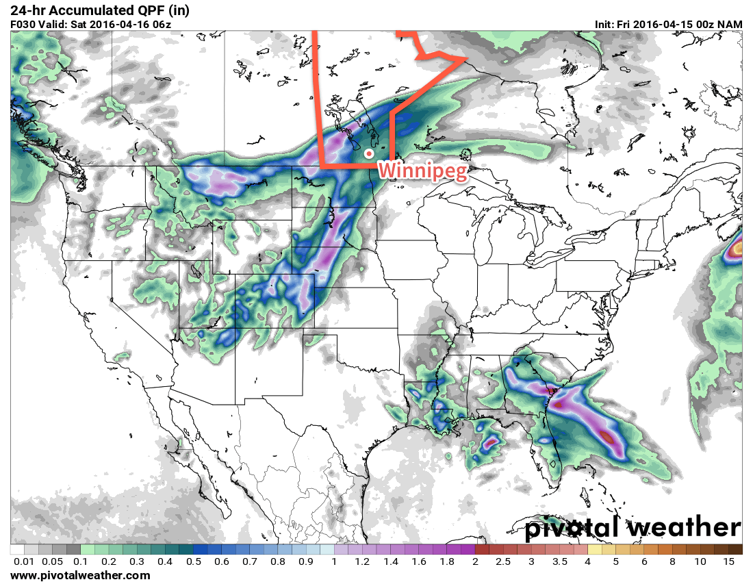
Saturday will bring cloudy skies and more rain to the region. For much of the day, rainfall will be confined to the east of the deformation zone, however by late in the day, a low pressure system will push through SE Manitoba, pushing rainfall further west into the Red River Valley before everything moves off to the east on Saturday evening. For areas along and to the east of the deformation zone, rainfall totals on Saturday will likely end up in the 15-30mm range, while areas west of the deformation zone in the Red River Valley end up with 5-15mm.

Forecast Rainfall Totals by Area — April 15/16, 2016
Location Rainfall Total (mm)
Friday Saturday Total
SW Manitoba 15-35 Trace-5 15-40
Red River Valley 15-25 Trace-35 15-60
SE Manitoba 10-20 15-40 25-60
Interlake 15-25 Trace-10 15-35
Precipitable Water values valid 21Z Saturday April 16, 2016
There is high confidence in elevated precipitable water values (relative to April), which confirms the potential of heavier rainfall in some locations on Saturday.

Throughout the duration of this event, it’s expected that all the precipitation will fall as rain, except for the higher terrain of the Riding Mountains & Turtle Mountain, where it may be mixed with periods of snow or freezing rain.

Unfortunately, at this point it’s practically impossible to refine rainfall amounts to anything more precise than these broad categories. As such, I’ve refrained from producing a rainfall forecast graphic as it’s simply too difficult to represent this spread in possible outcomes in a visual manner. We’ll try to provide updates as these systems continue to develop and mature.

The Rest of the Weather

Temperatures will be mild Friday with a daytime high near 12°C, however as the first impulse moves off to our east, cooler air will begin slumping southwards into the Red River Valley as northerly winds increase to 30-40km/h in the evening. Temperatures will dip to around 2°C on Friday night.

Saturday will be considerably cooler with a high temperature near 5-6°C in Winnipeg. The gusty northerlies will continue throughout the day. The wind will begin tapering off overnight as temperatures once again head to a low near 0°C.

Update: Sunday Switches to More of the Same

While originally we forecast that Sunday would bring clearing skies and warm temperatures, however dreams of sunshine will have to wait as this very complicated weather system’s evolution over the past couple days has changed the forecast towards a cooler and wetter variety.

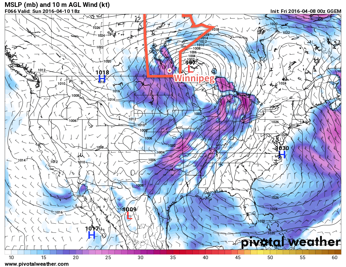
This morning, much of the Red River Valley is still seeing some remnant showers or drizzle from the disturbance that moved through last night. This light precipitation will ease a little bit through the morning, but another disturbance moving into the region midday will spread more rain into Southern Manitoba. Currently entering North Dakota, another area of rain will push north-northeast and then shear out along a southwest-to-northeast oriented deformation zone, allowing rain to push into the southern Red River Valley. Most models indicate that much of the rain that develops will fall through Steinbach and areas eastwards, while areas west and north see little to nothing. Looking at this morning’s satellite imagery, however, and it appears that the deformation zone that will delineate today’s precipitation is a touch further north and west of most model placements.

HRRR Simulated Reflectivity valid 21Z Sunday April 17, 2016
This simulated RADAR image from the HRRR model valid Sunday afternoon shows rainfall over the Red River Valley.

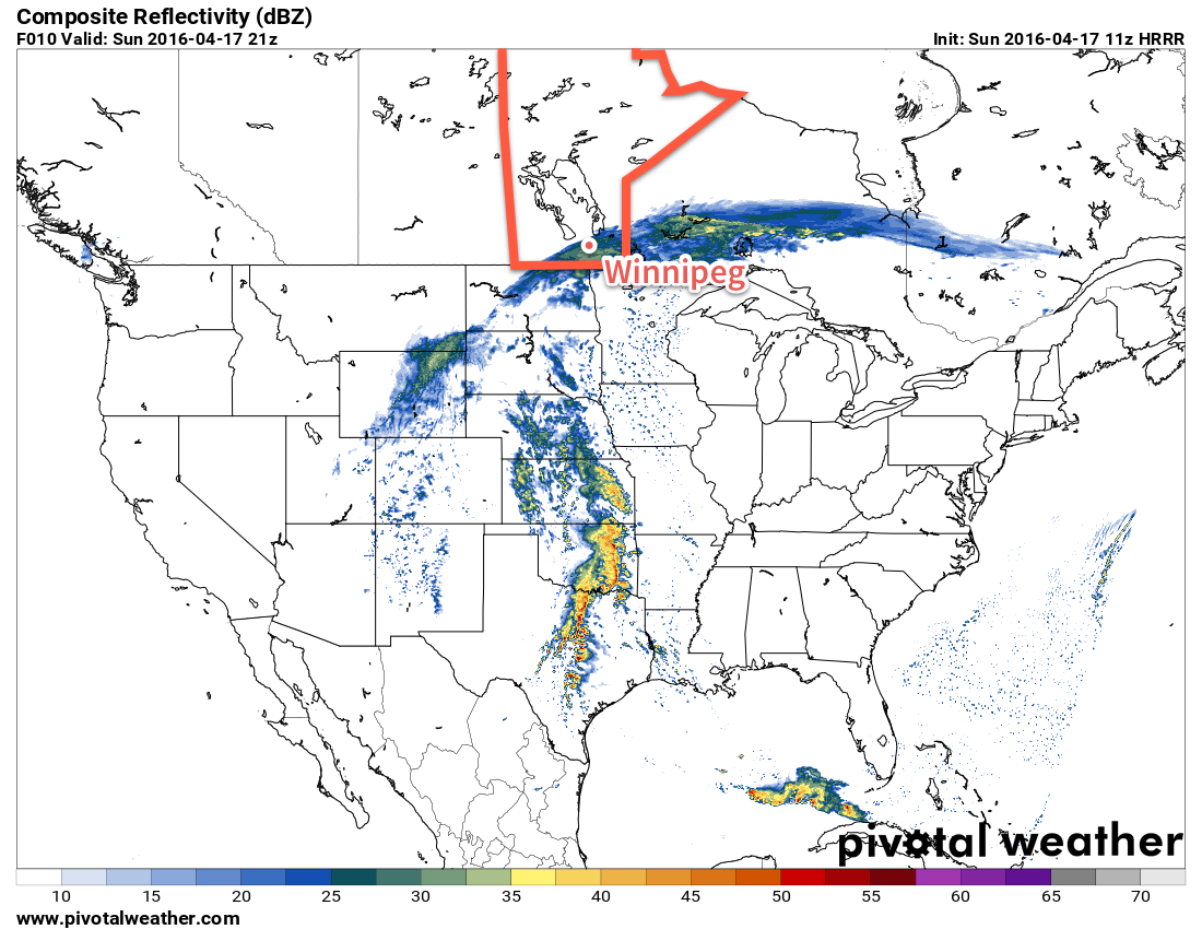
Some of the high-resolution short-range models such as the RAP and the HRRR are catching onto this fact and, as pictured above, are beginning to shunt the precipitation further to the northwest. So rather than clearing skies, we’ll likely see some shower/rain activity redevelop this afternoon for Winnipeg, the Red River Valley and points eastwards. Amounts will be quite a bit less than the past couple days, with just 2-5 mm for most places and local accumulations in the 5-10 mm range. Any rain activity will taper off overnight.

Other than the rain, it will be cool with a daytime high near 5°C and chilly winds out of north at about 20 km/h. Temperatures will dip close to freezing tonight and we should see clearing and warmer weather begin to work back into the region on Monday.

Winnipeg’s seasonal daytime high is currently 10°C while the seasonal overnight low is -2°C.


  1. Higher amounts that this are possible, but will likely be confined to small regions impacted more heavily by any convective elements that develop within the synoptic rain area.  ↩
  2. The deformation zone is a feature in the mid- and upper-atmosphere that firmly separates the warmer, more humid air associated with a low pressure system and the drier, colder air moving in behind it.  ↩

Warm Weather Brings First Major Spring Storm

While warmer will arrive in Southern Manitoba today with thanks to an abrupt switch to above normal temperatures, the bigger weather story on the horizon is the increasingly unsettled weather that will move into the region for the end of the week, culminating in what will most likely be the first major spring storm for Winnipeg & the Red River Valley.

Today will be the most pleasant day of the week as temperatures soar into the mid-teens with winds gradually increasing out of the southeast to around 30km/h for the afternoon. Skies will be fairly sunny, so all in all it will be a great day and boy, best to get out and enjoy it. Skies will begin clouding up tonight as the first of several systems approaches. Those breezy southeasterly winds will continue throughout the night. Into the second half of the night, some shower activity will begin spreading into the Red River Valley from western Manitoba.

Thursday will start off with some showers throughout the Red River Valley tapering off by mid-day. Temperatures will be quite mild with daytime highs climbing up to around the 17°C mark as a warm front pushes northwards out of the United States in response to a deep upper-level trough digging into the Plains from the Rocky Mountains.

GDPS 850mb Winds valid 06Z Friday Apirl 15, 2016
A strong southerly flow aloft will develop on Thursday, surging Gulf moisture northwards.

With the warm front developing over the region through the afternoon, a chance of some isolated showers or drizzle will continue throughout Thursday afternoon. Heading into Thursday night, the main event will begin to take shape: a major storm that will impact all of Southern Manitoba.

As this large-scale trough mentioned above develops, a significant amount of Gulf moisture will surge northwards through the Plains of the United States and head into Southern Manitoba, sending PWAT[1] values soaring to nearly 20mm above seasonal values. As a low pressure system pushes out of Wyoming and heads northeastwards into the Dakotas on Thursday night, a large area of rain will blossom over Montana, North Dakota and SE Saskatchewan and spread eastwards into Manitoba through the day on Friday.

GDPS 48hr. QPF Totals valid 00Z Sunday Apirl 17, 2016
While all the models show heavy precipitation for Southern Manitoba, they differ in placement.

The amount of precipitation is a relatively known quantity; it looks like 40-75mm over the course of 2 days is likely along the main axis of precipitation with amounts dropping to around 15-25mm along the edges of the precipitation. The challenge comes in where exactly this band of precipitation will set up, which will be determined by the position of the warm front and how far northwards it can push. The vast majority of the precipitation will fall to the north and northwest of the warm front, while drier and warmer weather remains to the south and southeast of the front.

There’s a chance that some of the rain may change over to snow on the western fringes of this system, most likely in the Melita, Virden and Minnedosa/Riding Mountain region. Depending on exact temperatures and the timing of the transition, it could mean a significant snowfall if the switch-over happens and it happens early enough.

For Winnipeg, the general consensus for 2-day totals tends to be around 45mm by Saturday evening. The nature of getting to that number varies, with the GFS producing a fair amount of rain on Friday and Saturday while the GDPS holds almost all the precipitation back until Saturday. We’ll have simply wait and see how exactly the warm front sets up to have a better idea of where the precipitation is going to fly.

Summary

Mild weather returns to Manitoba through the second half of this week, however with it will come the development of the first major spring storm of the year. A few showers will move through on Thursday morning, however the main event will occur through Friday and Saturday when a sharp warm front will separate temperatures in the mid-single digits over western Manitoba from near-20°C temperatures over southeastern Manitoba. To the north and northwest of this warm front, a significant rainfall event is expected, driven by a surge of moisture from the Gulf of Mexico as a deep long-wave trough digs into the Plains of the United States.

GDPS Forecast PWAT Anomaly valid 06Z Saturday April 16, 2016

By the time all is said and done, between 40-75mm is likely to have fallen along the axis of heaviest precipitation by Saturday evening. Where exactly this line lies will depend on exactly how far northwards the warm front is able to push; the uncertainty associated with this means that we simply have to wait and see how things develop to refine Winnipeg’s forecast for timing & amounts of precipitation.


With such a big system on the doorstep and so much uncertainty, we’ll be working ahead and getting our Friday forecast out at some point on Thursday evening rather than on Friday morning so that you can get a better idea ahead of time on what to expect for the weekend!

Winnipeg’s seasonal daytime high is currently 10°C while the seasonal overnight low is -2°C.


  1. Precipitable Water, a vertical integration of the amount of water vapour in a column of the atmosphere.  ↩

Cool Weather With A Windy Weekend

The cool weather will continue through the next few days with daytime highs struggling near 5°C below seasonal for early April. Heading into the weekend, the wind will be the biggest story as a low pressure system brings strong southerly winds to the region on Saturday and strong northerly winds on Sunday.

A ridge of high pressure situated over the province will bring cool temperatures, clear skies and light winds to Southern Manitoba today. In Winnipeg & the Red River Valley, temperatures will climb to a high near -4°C, some 12°C below seasonal values for this time of year. Tonight will be a cool night with overnight lows dipping below -10°C. Through the second half of the night, cloud cover ahead of an approaching low pressure system will begin spilling into Western Manitoba and towards the Red River Valley.

Windy Saturday

Saturday’s weather will be dominated by a fairly strong low pressure system moving across the province. The primary story for Winnipeg & the Red River Valley will be the strong winds associated with it.

RDPS 10m Wind valid 21Z April 9, 2016
Strong southerly winds (pink) will be in place over Southern Manitoba on Saturday.

Beginning mid-day on Saturday, strong southerly winds will develop over the Red River Valley southwards into the Dakotas. Winds will reach their peak by mid-afternoon with sustained winds of 50-60km/h with gusts up to 80km/h. The winds will then diminish in the evening as the low pressure centre moves over the region.

There will be a chance of some shower or flurry activity with this system on Saturday, but at this point it looks like a vast majority of the precipitation will remain to the north, primarily falling through Parkland Manitoba eastwards through the Interlake.

Temperatures will climb to around +2°C during the day under mainly cloudy skies.

Flurries Move in on Saturday Night Alongside Strong Northerlies

With the passage of the low occurring mainly on Saturday night, temperatures will remain relatively warm; by early Sunday morning the temperature is expected to dip to just -2°C. It will begin to feel a lot colder, however, as the low passes to the east and strong northwesterly winds begin moving in behind the system.

GDPS 10m Wind valid 18Z April 10, 2016
Strong northwesterly winds (pink) will be in place over Southern Manitoba on Sunday.

Sunday will be another cloudy day with decent chance of some flurry or light snow activity as temperatures climb to a high of +1°C. Winds will strengthen out of the northwest to 40-50km/h with gusts up to 60km/h. The wind ease to 30km/h or so on Sunday night as temperatures dip to -8°C for a low.

Long Range: Heading Into A Warming Trend

NAEFS 8-14 Day Temperature Anomaly Forecast — Valid April 15-22, 2016

After a lengthy stretch of below-normal temperatures, it’s beginning to look like we’ll finally see a taste of spring in the second half of next week as an upper-level ridge begins shifting eastwards and spreading milder air into Manitoba. Daytime highs of will climb towards 10°C by the end of next week. No significant precipitation is expected through the next 4-8 days at the moment.

Winnipeg’s seasonal daytime high is currently 8°C while the seasonal overnight low is -4°C.

Messy Winter Weather Continues

Winnipeg hasn’t see the last of the snow quite yet; after a mix of snow and rain yesterday, another mess of wintery weather is on the way later today as a low pressure system slumps through the province from the northwest. Afterwards, the Red River Valley will be left with generally cool weather with daytime highs below seasonal values.

Winnipeg will see but a brief reprieve from yesterday’s snowy & slushy weather before another low pressure system pushes into the province from Northern Saskatchewan and brings another shot of rain and snow to Southern Manitoba. Before that wet and messy weather moves in, Winnipeg will be stuck under mostly cloudy skies with light winds. Temperatures will be below normal today with daytime highs near +3°C.

RDPS 6hr. QPF valid 06Z April 7, 2016
The RDPS shows an area of precipitation moving across the Red River Valley on Wednesday evening

By late this afternoon, a mix of rain and snow will begin working its way into the Red River Valley from the northwest. This mix of precipitation will likely continue into the evening before changing over to just snow overnight as temperatures dip to a low near -3°C.

As the low pressure system passes to the east of the Red River Valley overnight, stronger northwesterly winds will develop with sustained winds of 30-40km/h and gusts to around 50km/h.

Thursday will bring more cloud to the region with the gusty northwesterly winds continuing throughout the day, sustained by a ridge of high pressure building in from the north. There will be a chance of light flurry activity throughout much of the day, but no significant accumulations are expected. The daytime high will be a bit cooler than Wednesday at +1 or +2°C, but as the ridge moves it brings much cooler air. It will be noticeable on Thursday night as the winds drop off and Winnipeg heads to a low near -10°C.

The sun should finally make an appearance on Friday as the weather over Southern Manitoba is dominated by a ridge of high pressure. This will result mainly sunny skies with light winds and very cool daytime highs[1] in the low minus single digits. Friday night will continue to be cold with an overnight low in the minus teens.

Long Range

Looking ahead to to the weekend and beyond, it appears that the generally cool temperatures will stick around until at least the middle of next week before a return to more seasonal values.

CPC 6-10 Day Temperature Anomaly Forecast valid April 11-15, 2016
The CPC is forecast below-normal temperatures for Southern Manitoba in the 6-10 day time period

The weekend looks like the most "active" period in the longer-range forecast as another significant low pressure system moves across the Prairies. Strong southerly winds will develop ahead of the low as it moves towards Manitoba through the day on Saturday[2], and then as they begin to diminish another mix of rain and snow will spread across portions of central and southern Manitoba. There’s uncertainty as to how much Winnipeg will see, but best indications are that most should stay north of the city.

Otherwise, the weather looks cool and calm through the first half of next week.

Winnipeg’s seasonal daytime high is currently 7°C while the seasonal overnight low is -4°C.


  1. Friday’s daytime high will be nearly 15°C below seasonal values!  ↩
  2. Sustained winds of 50 km/h are possible on Saturday with gusts as high as 70 km/h.  ↩