Weather Forecasts, Facts and News for Winnipeg & Southern Manitoba
Author: Brad
Brad lives in Winnipeg with his wife and two children and is the founder of A Weather Moment. He has loved weather from a very young age and has followed that passion through his life so far. He received a B.Sc. in Earth Sciences with Specialization in Atmospheric Sciences and is currently employed in the field of meteorology. You can find the author as WeatherInThePeg on Mastodon.
Today is off to a cold start after a cold front passed through the Red River Valley yesterday morning, ushering in winds up to 70km/h and some mixed-phased showers as the cooler air mass moved into the region. The cool-down will be short-lived, fortunately, as seasonal to above-seasonal temperatures will return for today & through the weekend.
Today and tomorrow’s dominant weather feature will be a ridge of high pressure that will move through the region over the coming two days. With it in place, daytime highs will be cool at a seasonal or slightly below-seasonal 9–10°C. Winds will be light, and both tonight and tomorrow night will see overnight lows dipping below the freezing mark to around –2°C.
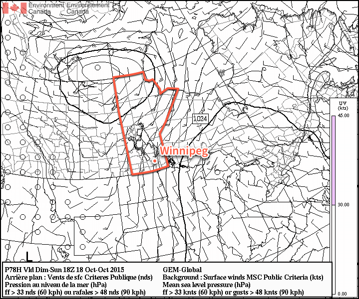
The GDPS surface wind forecast for midday Sunday shows a core of stronger winds as a result of the outflow from the ridge of high pressure to the east.
Sunday will see a sunny start to the day, but a bit of cloud push in for the evening and overnight hours. The biggest weather issue of the day will be strong southerly winds that develop as surface winds accelerate out of the ridge of high pressure to our east and are aided by the strong temperature gradient as warmer air moves in aloft.[1] As such, winds will increase–likely midday–to around 40–50km/h out of the south with some gustiness on top of it. It won’t be severe-level winds, but it will certainly be a windy fall day. Temperatures will be slightly warmer at around 14°C, kept lower than the air moving in over us would suggest by the cool outflow winds at the surface.
The winds will taper off in the evening and temperatures will head to around 6°C for an overnight low under partly cloudy skies.
The Week Ahead
Next week is looking fairly unremarkable for the most part. There appears to be a slight chance of some rain mid-week, and other than that, it’s nothing but sunny to partly cloudy skies and seasonal to slightly above-seasonal temperatures. Lovely weather for the second half of October.
Additionally, multiple models indicate the likelihood of enhanced anticyclonic curvature to the pressure gradient over the Red River Valley which, if true, will act to enhance the wind speeds. ↩
The warmer-than-seasonal warmth in place over Southern Manitoba will last just one more day before a cooler air mass works its way into the region behind a cold front that will push through on Thursday.
Today will bring seasonal weather to Winnipeg & the Red River Valley, albeit with a bit of a breezy wind. Under mainly sunny skies, the temperature will climb to around 15°C, which is nearly 5°C above the seasonal average high of 11°C for this time of year. Winds will pick up through the day and be fairly windy out of the northwest with sustained winds climbing to 30–40km/h with gusts to around 50km/h.
Temperatures will dip to around 4–5°C tonight with skies becoming partly cloudy before morning.
Thursday will be quite an unpleasant day that will see a cold frontal passage that will bring in blustery winds and falling temperatures. The day will start off with partly cloudy skies and temperatures climbing to around 10–11°C by midday. Winds will be windy out of the northwest at around 30km/h with some gustiness on top of that. As the cold front passes through in the afternoon, we’ll see mixed-to-cloudy skies develop with a very slight chance of some showers along the front as it passes through. No significant accumulations are expected. Winds will remain blustery with winds remaining at 30–40km/h with gusts as high as 60km/h.
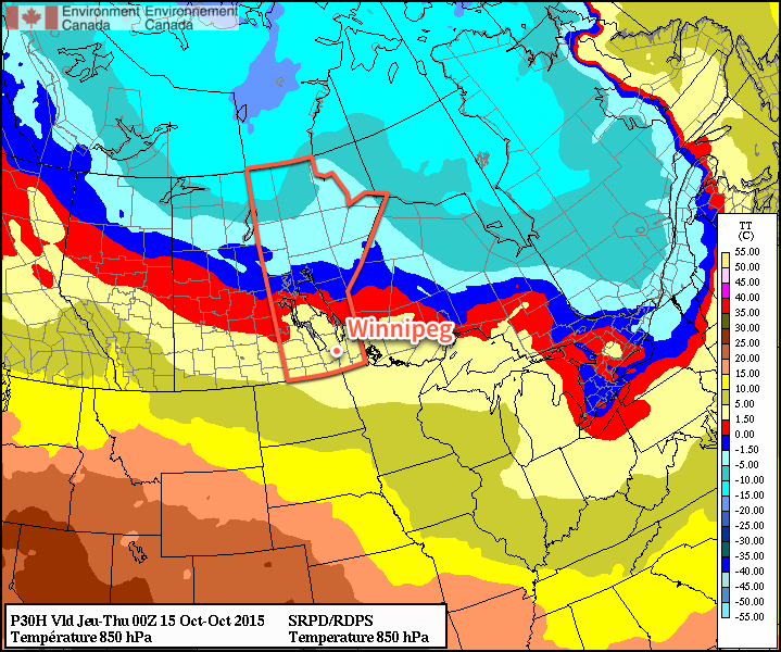
Looking at the forecast 850mb temperatures, the passage of the cold front on Thursday is quite obvious.
As the front passes through, temperatures will drop to around 6°C in the Red River Valley. They’ll continue to drop as winds taper off and skies clear, heading towards an overnight low near –2°C.
Friday will be a pleasant, but cool, day. Winds won’t be much of an issue and temperatures will climb to around 7°C under mainly sunny skies. The low on Friday night will once again be around –2°C under clear skies.
Unremarkable Weekend Ahead
Looking ahead to the weekend, there doesn’t appear to be much to say about it. Through the weekend temperatures will climb back towards seasonal values with a bit of wind on Sunday. No significant precipitation is in store for the region.
Next week looks to have a bit of variability to daytime highs and a couple chances for rain as a slightly more unsettled pattern develops.
An incredibly abrupt change is in store for Southern Manitoba as a powerful low pressure system is set to blast the near-record warmth out of the region and replace it with unquestionably fall-like weather. As it often is in the shoulder seasons, though, it’s going to be quite the spectacle.
Temperatures have soared into the mid–20’s quickly this morning, rapidly approaching the record high for Winnipeg of 26.1°C set in 1941. A powerful low pressure system to our northwest is approaching, though, and it is going to pack a mean cold front.
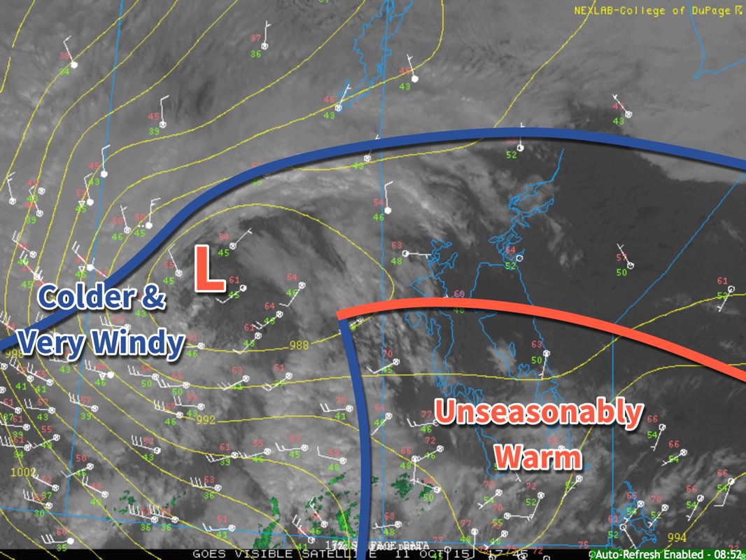
Surface analysis valid 12:45PM October 11, 2015
The midday surface analysis shows us three primary features. The first is the frontal wave with warm front across the northern Interlake and cold front draped southwards along the Manitoba/Saskatchewan border. To the southeast of these fronts is the unseasonably warm air mass that is bringing very warm temperatures to the region. The second feature is a low pressure center over central Saskatchewan. The last is a broad cold front that stretches from Central Alberta into Northern Manitoba.
Important to note is that the low pressure centre has occluded[1] and that there is a trowal developing (visible on the satellite image). This lonely low will trundle along for a little bit, until it can re-attach to the cold front slumping down behind it. The temperature gradient along the northern front is actually quite significant, and as the low re-attaches to that frontal wave, it will rapidly intensify. This low will move east-southeast as the steering flow amplifies and digs the upper-level trough.
While we may warm another degree or two, it’s more or less all downhill from here. Wind will continue to pick up out of the west-northwest late this afternoon to around 30km/h as an area of showers blossoms over Southern Manitoba. Widespread shower activity is likely much of the night as strong cooling aloft results in persistent destabilization of the atmosphere. Winds will remain around 30km/h with gustiness on top of that.
The real story will be when the cold front slams through early tomorrow. More rain is likely with the passage of the front, but winds will be the primary issue. As the cold front passes, winds will shift to be out of the northwest and pick up in speed significantly. Sustained winds will likely reach around 55–65km/h, but very strong gusts are possible; it’s highly likely that Winnipeg & the Red River Valley will see wind gusts to 90km/h, however with very strong winds within the conditionally unstable layer and precipitation very likely, it’s possible that wind gusts exceed 100–110km/h. Winds at these speeds can be hazardous when driving and cause damage to buildings (especially roofs) and trees.
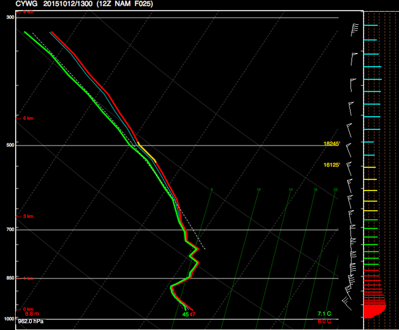
NAM forecast sounding for Winnipeg, valid 12Z October 12, 2015
This forecast sounding for Winnipeg from the NAM shows very strong winds near the surface, with up to 60kt present at the top of the low-level instability.
The strongest winds will begin to subside mid-to-late morning, but strong northwesterly winds of 50km/h gusting to 70km/h will likely be in place for the remainder of Monday. The day will start of with a temperature around 9 or 10°C and see it drop to around 4°C by the end of the day. The bulk of the precipitation should taper off with the winds mid-morning, and when all is said and done, this system will likely produce around 5–10mm of rain over the Red River Valley, although for the northern half, there’s a slight chance of seeing more along the lines of 10–15mm.
Environment Canada has issued a wind warning for the Red River Valley regarding this system with the following discussion:
An intense low pressure system will track across central Manitoba tonight and Monday morning. A strong cold front extending southward from this low will sweep across southern Manitoba tonight. Very strong northwest winds will develop in the wake of this cold front with the strongest winds in the Red River Valley as winds will funnel down the valley. Sustained winds of 60 to 70 km/h with gusts over 90 km/h are likely beginning late tonight and lasting until early afternoon on Monday. Winds will gradually subside Monday afternoon from west to east as this system heads off into Ontario.
Damage to buildings, such as to roof shingles and windows, may occur. Loose objects may be tossed by the wind and cause injury or damage. Be prepared to adjust your driving with changing road conditions due to high winds. Avoid wooded areas to prevent injury from falling trees or branches. Campers should move to sturdy shelters.
Be sure to tie up any loose objects and remove fabric canopies from gazeboes. Bring in any objects that could catch the wind, and maybe flip your trampolines over so the wind doesn’t do it for you. It’s going to be a bit of a busy night and a wild Monday morning, so batten down the hatches!
Occlusion is a part of the natural life-cycle of low pressure systems. In simple terms, it means the low has “detached” from the fronts. ↩
Welcome to Weather News This Week, a new feature here on A Weather Moment that will alternate with our existing Elsewhere in Weather News feature. Expect to find a collection of interesting links to writings elsewhere that cover weather events and news as well as advances in the science of meteorology. Let’s get right to it!
Arstechnica took a look at how the language used by climate scientists when talking about climate change differs dramatically from those who oppose them:
[…] language itself is not an indication of the strength of the evidence; it can really only tell us how people are using that evidence to make an argument, and whether they’re doing so tentatively or forcefully. So, looking at how two opposing sides of a scientific argument use language to make their case can tell us something about their thinking.
It can be especially interesting to look at the use of tentative and forceful language in the case of climate change, where the language can be inflammatory. Scientists who describe the likely future path of our habitat often face the accusation of “alarmism.”
Srdan Medimorec and Gordon Pennycook, two graduate school researchers at the University of Waterloo, are interested in how people form beliefs on the basis of argument. They decided to look into the writing of opposing groups—climate scientists and people who refuse to accept the evidence on climate change—to see whether there was a consistent difference in language use.
Over on the Boston Globe, they have a fantastic gallery of images of the historic flooding that occurred in South Carolina.
Flooding around Aberdeen Country Club, on Oct. 6 in Longs. S.C.. (Janet Blackmon Morgan/The Sun News via AP)
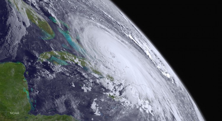
The flooding in South Carolina was some of the worst on record and was a result of a quasi-stationary upper-level low anchored over the southeastern U.S. that was able to tap into moisture from Hurricane Joquain. The result was a band of torrential rain and thunderstorms that remained in place for several days, resulting in absolutely smashed rainfall records for many locations which saw more than 20 in (500+ mm) of rain.
On Wednesday, September 30, less than six days from a potential landfall, the ECMWF operational model was consistently keeping Joaquin offshore, even as the GFS and nearly all other models were bringing the hurricane into the U.S. East Coast. From late Wednesday into Thursday, the GFS and other models began to shift toward an offshore track for Joaquin, as the hurricane itself was still diving southwestward into the Bahamas. By Friday, there was virtually unanimous model agreement on the offshore track that proved accurate.
“People are turning to me less and less for what to wear to work and more for an explanation on the more intense and more frequent weather anomalies,” said Wagstaffe, an on-camera meteorologist for the CBC, Canada’s public broadcaster.
“The audience is getting more hungry for knowledge about what’s happening with the weather, and why. The story about climate change is becoming more interesting and what it will mean for our future.”
How Wagstaffe does her job has also changed. There’s more and better satellite and information technology to work with, but the so-called “normal” weather patterns that acted as benchmark have been out of whack in recent years. That includes this summer, when some of the models used to look at the longer-term forecast had to be ignored because of the hot and dry summer in Western Canada and the soggy and cool conditions in Central and Eastern Canada.
Over on the Winnipeg Weather blog, Julien has compiled a few statistics for Summer 2015 in Winnipeg. The whole thing is worth a read, but he especially made some interesting observations about summer humidity in Winnipeg:
In the last 20 years, 9 years saw a top 10 most humid summer since 1953. Summers have become increasingly humid since the 1990’s and this is easily seen in the graph below. The graph shows the top 20 most and least humid summers (red and blue dots) and the 30-year running mean (green line). Whether or not the increasing humidity is a trend that will continue is unknown. With only 63 years of dewpoint records, there simply isn’t enough data to see if there were similar humid periods in the past.
Graph showing a trend of increasingly humid summers in Winnipeg. 1980’s normal summer average dewpoint was about 11.5°C. Today’s normal is now close to 12.8°C.
July and August were particularly humid. With an average dewpoint of 16.1°C in July, it was the second most humid July and month on record since 1953. Only July 2012 was more humid with an average dewpoint of 16.5°C. August tied with 2003 for 14th most humid with an average dewpoint of 13.7°C.
That’s it for this week; we’ll be back in a fortnight with more weather-related reading for you! If you like the idea of this and have any suggestions for format or content, leave us a comment below!