Risk of Thunderstorms to Start the Week

One of our first risks for thunderstorms will come early this week.

image

The green area outlines the risk of thunderstorms on Tuesday

Monday

Monday
image
Mainly cloudy. Chance of showers.
21°C / 15°C

Today should be a generally dry day in Southern Manitoba with only a chance of showers. There is also a slight risk of a thunderstorm, but any storms that develop will be relatively weak. Temperatures will be in the upper teens or lower twenties in most areas under mainly cloudy skies. The wind will be from the south-east.

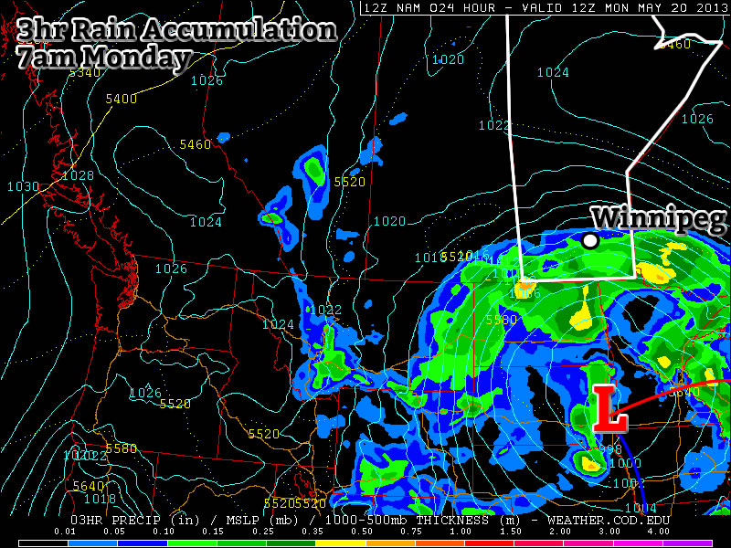
Our next reasonable chance for rain will likely come tonight night as a powerful impulse generates an area of rain. This rain is currently expected to be heaviest over Western Manitoba, but may affect the Red River Valley as well, albeit with lesser amounts. It is entirely possible that this rain could miss us completely, but it is too early to say exactly what will happen.

Tuesday

Tuesday
image
Risk of a Thunderstorm
23°C / 10°C

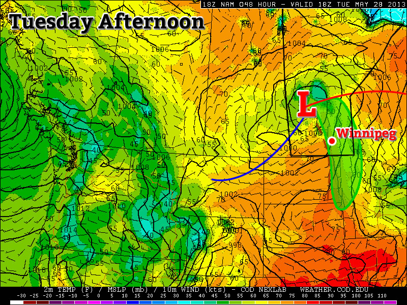
Tuesday should feature our best chance of thunderstorms this week. A low pressure system and its associated cold front will pass through Southern Manitoba at some point during the day – likely through midday – and may trigger some storms. These storms are expected to be non-severe, but if there is a bit more instability than currently expected, there is a very slight chance that one of two may become marginally severe. The main risks with any storms that develop will be hail, perhaps up to nickel size, and gusty winds. The storms should be fairly fast moving so heavy rain is a lesser concern. Other than this chance of thunderstorms, there will also be a general chance of showers through the day. Temperatures will be in the low, or maybe mid twenties (depending on how the weather features setup), with a southerly flow switching to a westerly flow after the frontal passage.

Wednesday

Wednesday
image
Mainly Sunny
23°C / 8°C

No significant precipitation is expected in Southern Manitoba on Wednesday, except again for the odd shower. Temperatures will be in the upper teens or lower twenties with mainly sunny skies.

Long Range

At this point the long range forecast is fairly ambiguous, as it often is at this time of year. In the nearer term, it appears we may experience another significant rainfall event later this week as a powerful low pressure system develops to our south. This system may trigger severe storms in the US Plains, while bringing us a bought of rainfall. In fact, this system is looking quite similar to the one that brought parts of Southern Manitoba 200mm of rain and triggered severe storms, including the Moore, OK tornado, in the US a week ago. There is still significant uncertainty in terms of how this next system will play out and at this time it isn’t expected to produce the massive rainfall amounts that the last one did. We’ll have more details on this system on Wednesday. What happens beyond the end of this week is too uncertain to discuss right now.

Increasingly Unsettled

A massive upper low currently bringing copious amounts of rain to Southern Alberta will bring increasingly unsettled weather to Southern Manitoba as it flattens the upper ridge over the Eastern Prairies allowing weaker disturbances to push further east.

Today and Tonight

Friday

19°C
Increasing cloudiness in the afternoon; becoming windy.
Friday Night

10°C
Showers beginning in the evening.

We’ll see a pleasant day today with sunny skies for most of the day and our temperature recovering fairly quickly from our chilly overnight temperatures. We’ll see a high of 19°C today with winds increasing out of the south through the day to 40km/h with gusts as high as 60–65km/h. Clouds will begin pushing into the region later in the afternoon ahead of this evening’s weather.

RDPS 12hr. QPF valid 12Z Saturday

Rainfall accumulations for Friday night from the RDPS.

This evening, a low-level jet will push into the Red River Valley which will initiate and sustain an area of scattered showers stretching from North Dakota north-northwestwards across Southern Manitoba and into Saskatchewan. These showers will slowly push eastwards through the Red River Valley overnight giving generally 2–4mm accumulations with the potential for 5–10mm of rain under any slightly heavier showers that may get going.

The Weekend

A few remnant showers will linger through Saturday morning before tapering off and leaving more cloud than sun through the Red River Valley in the afternoon as we climb to a high of 19°C. More cloud will push in overnight as we drop to around 9°C.

Saturday

19°C / 9°C
A few showers ending in the morning then a mix of sun and cloud.
Sunday

17°C / 10°C
Mainly cloudy. Chance of afternoon showers.

Sunday will be a cloudy day with a chance of afternoon showers as a weak disturbance skips along the international border. Areas close to the border will see a much greater chance than we will in Winnipeg but anywhere that sees showers will likely see fairly minimal amounts, only a mm or two. The clouds will keep the high a bit cooler than the previous couple days at only around 17°C. Sunday night will be mainly cloudy with the temperatures dropping to about 10°C.

A Chance to Dry Off

We’ll see sunny skies through the rest of the week and a chance to dry off after as much as 100mm of rain fell over Southern Manitoba over the weekend. The heavy rain caused a few problems of the weekend, mainly constrained to rapidly rising streams and rivers (which rose as much as a meter) and significant overland flooding. Thornhill, MB was particularly hard hit with enhanced rainfall occurring from the upslope enhancement of the western Red River Valley escarpment under northeast winds. It has been reported that 200mm or greater fell in the region, but with such sharp contrast to how much fell in nearby Morden (89mm) and CoCoRaHS reports totalling 2–3” (~ 50–80mm), it has to be considered an extremely localized event. Nonetheless, areas very close to the western escarpment were hit very hard by this rainfall event.

All that to say it was a very wet weekend that was easily the biggest rainfall event of the year. Some notable rainfall totals:

City/Town Rainfall (mm)
Deerwood 101
Morden 89
Somerset 81
Winkler 77
Manitou 76
Sprague 73
Letellier 71
Killarney 69
Carman (Ag.) 68
Altona 67
Boissevain 62
Carman (EC) 58
Gretna 58
Deloraine 55
Emerson 55
Morris 54
St. Pierre 52
Kleefeld 46
Treherne 41
Pilot Mound 40


Winnipeg 18–24 (Official)
29–34 (Unofficial)
Portage la Prairie 18
Brandon 16

It’s easy to see that the heaviest rainfalls fell in the SW Red River Valley, with lesser amounts east of the Red River and rapidly diminishing amounts near the Trans-Canada Highway. Fortunately, no rainfall is in the forecast for this coming week, which should provide the opportunity for things to dry off and a chance to get out there and cut your grass which, if it’s anything like mine, decided to grow about 4” over the past few days.

Wednesday

20°C / 3°C
Mainly sunny & breezy.
Thursday

17°C / 4°C
Mainly Sunny
Friday

19°C / 9°C
Mainly Sunny

We’ll see mainly sunny skies the next few days as a large surface ridge pushes through the province. High temperatures will be restricted into the mid-to-upper teens as cooler air aloft dominates along with a northeasterly wind that will keep cooler, dryer air feeding into southern Manitoba. Winds will still be a factor today as they increase to around 30–40km/h once we warm up a little bit. Winds will be a lesser issue on Thursday as the surface ridge lies right on top of us and the light winds slowly shift to southeasterly as we enter the return flow on the back-side of the ridge. For Friday, winds will likely pick up late in the day or overnight as the surface pressure gradient tightens up over southern Manitoba again as a low pressure system pushes into eastern Montana/the western Dakotas. Before then, though, the winds will likely be quite calm. Our high on Friday will push back towards the 20°C mark, but likely stop just short of it.

The return flow also looks to be tapping into a bit of moisture in the Central Plains which will begin increasing our dew points heading into the weekend. For us, it will just mean the assurance that we’ll stay much warmer at night (closer to 10°C than 5°C), but for further west in Eastern Saskatchewan it looks like the moistening air may provide fuel for the first organized thunderstorm events of the year.

The Weekend

The weekend looks to be fairly benign at this point over Southern Manitoba. It looks like the atmosphere is setting up into a weak blocking pattern once again with a large upper low spinning over the B.C. Interior and Alberta with upper ridging over the Eastern Prairies. There may be a few shortwaves that ride up the ridge, but at this point it looks like if any shower activity were to push into Southern Manitoba, it would be constrained close to the Saskatchewan border. At this point, I’m comfortable saying that we’ll probably see a mix of sun and cloud with highs in the low 20’s here in the RRV this weekend, with more showery, stormier weather confined mainly to our neighbours in Saskatchewan.

Wet End to a Wet Long Weekend

This long weekend will end on a rainy note – big surprise! Conditions should gradually improve as we move into the work week.

image

A significant weather system will spin just to our south for the next couple days

Monday and Tuesday

Monday
image
Periods of Rain
11°C / 7°C
Tuesday
image
Periods of Rain Ending
14°C / 5°C

A powerful weather system over the Dakotas/Minnesota region will continue to bring rain to Southern Manitoba on Monday. Weather models wrap a band of rain through much of Southern Manitoba through all of Monday and even into Tuesday. Models are struggling to resolve the intensity of this rain and therefore total accumulations are a major question mark. If this band does indeed stall through Southern Manitoba for the next day and a half as models indicate, then storm total accumulations could well be in the 50 to 100mm range that models are predicting. On the other hand if things pan out differently than the models predict, which looks probable, then we’re probably looking at more like 30 to 60mm on a widespread basis (these numbers include Sunday accumulations as well by the way). I believe there is a sufficient moisture feed for those high end amounts (close to 100mm) on a localized basis. However, the intensity of rain appears to be lower than model predictions, so I think in general storm totals will be closer to the 30-60mm range mentioned above. Either way a lot of rain will be had today and tomorrow, not the way most people had hoped to spend their Victoria Day.

Wednesday

Wednesday
image
Mainly Sunny.
20°C / 5°C

Conditions should improve for Wednesday as we experience a brisk north-easterly flow behind Monday’s system. Temperatures should be in the upper teens or lower twenties.

Long Range

The late week outlook looks fairly seasonal temperature wise, with little or no additional precipitation. Long range guidance doesn’t give a clear picture of how the rest of May will play out. It doesn’t appear that we’re headed for any kind of significant cool down, but a large warm up doesn’t look likely…hopefully the long range forecast will show more clarity later this week.