Unsettled Weather to Continue

This week will continue to be unsettled weather-wise. It appears that we will see the chance for rain virtually every day for the next several days.

A trough of low pressure over the Prairies

A trough of low pressure over the Prairies (the jet stream is in blue)

A trough of low pressure sitting over the Prairie provinces will be responsible for our unsettled weather over the coming days. This trough is created due to the fact that the jet stream will be to our south, allowing cooler air from the north to spill down into lower latitudes. As weather systems track along the jet stream they will create chances for rain in Southern Manitoba. It appears that rain is a possibility on every day from Monday through Thursday. At this time it looks as though rainfall amounts on Monday and Tuesday will be fairly light, if it rains in your location at all, but the precipitation forecast for later in the week is less clear.

Due to the cloudy and potentially wet conditions expected on Monday and Tuesday, temperatures won’t be very warm. Highs on Monday will generally be in the high teens over Southern Manitoba, except for border regions and parts of south-eastern Manitoba where temperatures should be closer to twenty degrees. Tuesday is likewise expected to remain cool, with highs in the mid to upper teens expected. Temperatures on Wednesday will be governed by when and if it rains, but it doesn’t look like it will be warmer than twenty for midweek (if it indeed gets that warm at all).

Too much uncertainty exists in the forecast at this point to talk about the weather much beyond Wednesday. However, at this time it doesn’t appear that we will be going back into a prolonged spell of nice weather in the short-term.

Stormier Weather Set To Return

Southern Manitoba will be under an increasing risk of thunderstorms as the week progresses. Heat and humidity will slowly build back into the region as a deep upper trough begins to build over the Rocky Mountains before tracking eastwards across the Prairies later in the week.

GEM-REG 6-hour Precipitation for Thursday Afternoon

6-hour accumulated precipitation through Wednesday afternoon from the GEM-REG model.

We’ll see warmer temperatures today as warmer air pushes in behind a warm front that passed through overnight. Daytime highs should be near the 25°C mark through most of the RRV. By this afternoon a weak frontal wave will be positioned near the international border with a trough extending NW to a low pressure system tracking into Western Manitoba. Showers and thunderstorms will develop over SW Manitoba early this afternoon and slowly develop northeastwards into the Red River Valley. It will mainly be regions through the northern Red River Valley that face the risk for showers or thunderstorms (Portage la Prairie, Winnipeg, Selkirk; as seen in the image above). The showers and thunderstorms will lift northwards into the Interlake overnight while overnight lows drop to the mid-teens over most of Southern Manitoba.

12 hour accumulated precipitation through Thursday

12 hour accumulated precipitation through Thursday from the GFS model.

Opinions differ for Thursday, however it’s generally expected that a north-south band of showers with a chance of an embedded thunderstorm will develop over the Red River Valley or the Whiteshell in the afternoon. This line will slowly move eastwards and intensify into a band of thunderstorms. Again, there’s still quite a bit of uncertainty to where this line will develop, and the potential exists for fairly large (close to 1”) rainfall accumulations. We’ll be keeping close track of this system’s development.

Friday looks to be a fairly nice day with comfortable humdity and daytime highs in the mid-20’s. A large MCS is forecast to develop on Friday night in North Dakota, bringing the chance for a stormy and rainy Saturday. We’ll take a closer look at that system later this week.

What a Difference a Week Can Make

The difference between the weather experienced last week and that which is coming for early this week will be quite extraordinary. Temperatures on Monday look to be nearly 20 degrees cooler than values experienced last week.

850mb temperatures (about 5000ft above the ground) are forecast to sink to near or below zero degrees on Monday

850mb temperatures (about 5000ft above the ground) are forecast to sink to near or below zero degrees on Monday

High temperatures on Monday are not expected to stray far from the 10C mark in Southern Manitoba. Eastern most sections in the south may manage to hit the mid teens, but the rest of Southern Manitoba shouldn’t be much warmer than 10 degrees. This comes as quite a contrast to the 30 degree temperatures of last week. The above graphic shows the extent of the cold air, with freezing temperatures just 5000 or so feet above the ground. We will most likely see some shower activity develop across Southern Manitoba on Monday, but amounts should be relatively light in most areas. Thankfully Tuesday and Wednesday will be warmer, with highs moving sharply higher. Tuesday should be near or above twenty degrees (depending on which model you believe), while Wednesday is expected to be in the low to mid twenties. There may be some convective rain and/or thunderstorms on Wednesday as humidity levels increase ahead of an approaching low pressure system.

The Preliminary outlook for later this week is for more warm to hot weather. Highs back in the middle or upper twenties will be possible on Thursday and Friday according to the latest modelling. However, my confidence level in the late week forecast is lower than normal since there is some uncertainty as to how quickly a series of fronts will pass through the province late in the week. Given my lack of confidence in the Thursday-Friday forecast I won’t say much about the weekend. You can read more about longer range predictions in the next paragraph.

The long-range forecast calls for above-normal temperatures in Southern Manitoba for the second half of June

The long-range forecast calls for above-normal temperatures in Southern Manitoba for the second half of June

The NAEFS forecast seen above shows the long-range temperature forecast for the June 18-25 period. It appears that we will stick with above-normal weather for most of the second half of June. Also note that we are on the edge of the warmest air, meaning that approaching systems coming out of the colder air to our west (a trough) could potentially trigger strong thunderstorms as they interact with the warmer air to the east. This type of trough-meets-ridge pattern is to blame for the severe thunderstorms on Saturday night.


AWM Chases!

The A Weather Moment team took to the highways of Southern Manitoba on Saturday for our first chase of the year. Hot and humid surface weather combined with an approaching low pressure system and a strong jet stream aloft made conditions ripe for severe supercells thunderstorms which could potentially produce tornadoes.

A thunderstorm east of Altona on June 9, 2012

A thunderstorm east of Altona on June 9, 2012

The AWM team decided to drive toward Holland, MB to start the day. After arriving in Holland it was decided that Pilot Mound would be an appropriate new target given the new weather information available. Upon arriving in Pilot Mound and watching the latest weather conditions evolve we felt our location was ideal. At that point it was time to wait…and wait..and wait. After watching numerous towering cumulus clouds fail to breach the cap we decided to abandon Pilot Mound and follow some storms to our east which were approaching the Red River Valley. As we began to get a good visual of the storms around the Altona region it was clear that there was little chance of a tornado. Cloud bases were high and there were no significant lowerings to be found – the storms were elevated – not surface-based tornado producers. Nevertheless we stopped for awhile near Altona to take a closer look at the storms, a look which revealed nothing of significance. Having taken a few anvil and sunset photographs it was time to head back toward Winnipeg, just missing the infamous hailstorm (which put down tennis ball sized hail) that hit the city around sunset.

Overall it was a good chase. It was not a complete bust since there were storms, but it was definitely a bust in the fact that tornadoes were really nowhere to be found (I’ve kept the door open here for you to decide whether or not this is a tornado: http://tornadohunter.ca/tornado-hunter-blog/2012/6/10/the-longest-chase-day-ever-but-we-got-a-tornado.html). It is only early June and the severe weather season is just beginning, the next chase will be here before we know it.

The AWM team (Brad, Scott and Matt) would like to thank the 311 unique visitors who made 624 visits to this website yesterday, a new record number of visits for this website. Thank-you.

Tornado Threat To Develop Over Southern Manitoba on Saturday

3km EHI Values

3km EHI Values. This measures the potential strength of a tornado should one develop. As can be seen, the GFS EHI values have gone off the chart over extreme SW Manitoba on Saturday afternoon.

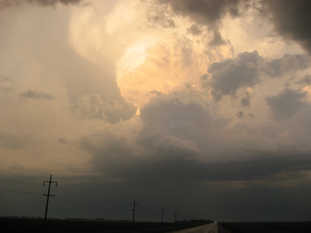
A slow-moving low pressure system pushing into our region will set the stage this weekend for the potential of supercell thunderstorms capable of producing localized flooding, extremely large hail, damaging wind gusts and tornadoes. Read past the break to get all the details, our thoughts on the main threat areas, and to see updated information in the comments.

Jump to Live Twitter Feed

An extremely slow-moving long-wave trough has been slowly pushing it’s way eastwards this week. While it’s been a good distance from us, we’ve been able to enjoy the benefits of such a setup: plenty of nice, warm weather with comfortable humidity. Our friends in the Western Prairies haven’t had it quite as nicely; multiple rounds of storms have pushed into Southern Alberta & Southwestern Saskatchewan over the past couple days, bringing multiple tornadoes to Southern AB and torrential rain that caused localized flooding after 2-3” fell in a short period of time. Large hail was also reported in many storms across the Western Prairies, as well as with some severe thunderstorms that developed over SE Saskatchewan on Wednesday evening.

Entrance of this system in our region has been marked by the thunderstorms and showers that developed overnight. We should see most of these clear from the Red River Valley this morning or by early afternoon if they’re really tenacious. We’ll see a relatively pleasant afternoon, with some lingering cloud and temperatures in the low-to-mid 20’s. The dewpoint will be quite high, making it feel a little sticky, though.

The main surface low begins to move into our area on Saturday, pushing a warm front up from North Dakota into extreme Southern Manitoba. Using the basic MIST principles of thunderstorm forecasting:

  • Moisture: Plentiful. Surface dewpoints will be sitting near 20°C across Southern Manitoba, with 850mb dewpoints pushing up towards 15-17°C. This deep layer of moisture will provide plenty of energy for storms to work with.
  • Instability: The major inhibition to storms will be a layer of warm air at 700mb. Temperatures will climb to 10-13°C at 700mb on Saturday morning, however cooler air will push in later in the afternoon, helping destabilize the mid-levels. LI values of -8 to -11, combined with CAPE values anywhere from 2500 J/kg to 5500 J/kg are evidence of an extremely unstable atmosphere.
  • Shear: With a decent upper-level jet pushing in through the day, most areas across southwest and south-central Manitoba will see bulk shear values increase to 30-40kt by evening.
  • Trigger: A warm front draped across Southern Manitoba will be strong enough to initiate convection in the mid-to-late afternoon as the cap begins to erode.

Prog Tephi for SW MB

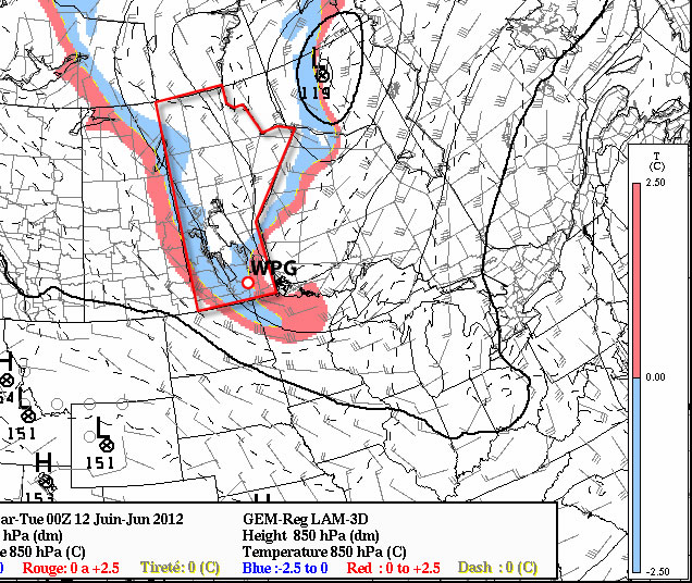
Prognosis tephigram for Southwestern Manitoba on Saturday afternoon. Note the extremely favorable veering wind profile present.

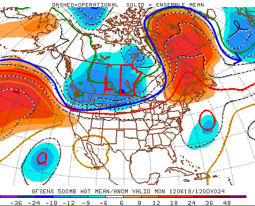
Models strongly disagree about the speed of this system, but agree that it has a very strong potential to produce damaging supercell thunderstorms capable of producing tornadoes. The greatest uncertainty, then, is where exactly the storms may form. Unfortunately, as I write this it’s still too early to tell exactly where the greatest threat lies. The slowest solutions would place the main risk over extreme SE Saskatchewan across SW Manitoba, while the quicker solutions would place the risk over SW Manitoba into the Red River Valley. Personally, I feel that the slower solutions are probably a little more true to what’s going to happen. With that in mind, here’s my threat area for Saturday:

Day 2 Storm Outlook

Day 2 Thunderstorm Outlook, valid Saturday afternoon through Sunday morning. This is subject to refinement as this system develops and more certainty exists on it’s track and speed.

A large MCS will likely develop as the whole system lifts northwards overnight, which will continue to provide a severe weather threat in the form of strong winds and large hail. It will push through the RRV by Sunday morning. We may see the threat for another round of thunderstorms on Sunday afternoon, however they are not expected to be severe. Things will finally cool off on Monday as the main upper low moves through and draws in cooler, dryer air from the west.

We’ll be sure to refine the forecast in the comments below as the day approaches. In addition, it looks like the AWM crew will be out chasing, so we’ll be sure to have some live updates should everything work out. Stay sky aware out there this weekend!


new TWTR.Widget({
version: 2,
type: ‘list’,
rpp: 30,
interval: 30000,
title: ‘June 9, 2012’,
subject: ‘AWM Storm Chase’,
width: ‘auto’,
height: 500,
theme: {
shell: {
background: ‘#3c3c3c’,
color: ‘#eeeeee’
},
tweets: {
background: ‘#eeeeee’,
color: ‘#2c2c2c’,
links: ‘#489ce1’
}
},
features: {
scrollbar: true,
loop: false,
live: true,
behavior: ‘all’
}
}).render().setList(‘buffaloseven’, ‘awm-team’).start();