Drying Out with Seasonal Temperatures

After a rainy weekend we’ll have a chance to dry out this week as skies clear. Temperatures will be cool, but generally near seasonal values.

Cool and windy conditions are expected on Monday in southern Manitoba

This Week

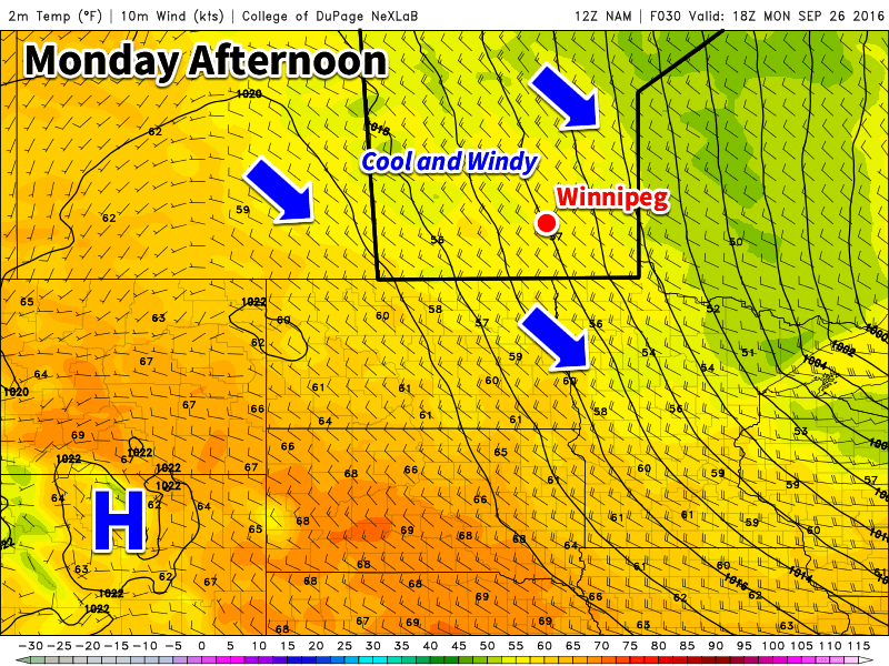
Today will see mainly sunny skies as the low pressure system from the weekend moves off to the east. However, it will remain quite windy behind the system with northwesterly winds of 40 km/h gusting to 60 km/h. Temperatures will sit in the mid teens over most of southern Manitoba. There will be a slight risk of frost in low-lying areas tonight as temperatures drop rapidly with the light northwesterly flow.

Tuesday will see slightly improved weather over today as winds calm down and temperatures climb up into the mid teens. Skies will also remain mainly sunny, making for a generally pleasant day.

Wednesday should be one of the warmest days this week. Temperatures are expected to climb up near the 20C mark under light southerly winds and mainly sunny skies.

Long Range

Long range models hint at another strong low pressure system developing to our west later this week. It remains unclear if and when this system may affect us, but it likely won’t be until the weekend at the earliest. The good news is that this system will draw up a warm, southerly flow, perhaps giving us a brief stretch of warm weather before it arrives.

Cooler Weather to Start the Week

Cooler weather is on tap earlier this week as a series of cold front usher in a much cooler air mass. While temperatures will remain only slightly below seasonal averages, some areas will stand a risk of frost.

A cold front will bring cooler weather to southern Manitoba today

This Week

Today will be cool and breezy as a series of cold front brings cooler weather to southern Manitoba. The first cold front passed through late Sunday, with a secondary cold front coming through later today. The initial cold front dropped temperatures into the teens for today, and was followed by fairly extensive cloud cover. The second cold front will bring a chance of showers to most of southern Manitoba today as it passes through and picks up any residual moisture. Parts of western Manitoba that clear out tonight may experience light frost as temperatures drop rapidly after sunset. Winds will be gusty out of the north-west at 30 km/h gusting to 50 km/h.

Following today’s frontal passage, we’ll experience one of the coolest days in awhile on Tuesday. High temperatures will only be in the mid teens. Some cloud cover is expected to develop during the day, but no precipitation is expected, save for perhaps an isolated light shower. There will be a risk of frost again Tuesday night, but it should be more isolated and mainly in traditionally frost-prone low-lying areas. Most parts of southern Manitoba should remain just above freezing due to a weak southerly flow overnight. Daytime winds will be westerly at 20 km/h.

Temperatures will begin to warm on Wednesday as we see a southwesterly flow begin to develop over southern Manitoba. Highs should climb up toward the 20°C mark under mainly sunny skies.

Long Range

The long range forecast suggests that summer weather may not be quite over yet! Weather models hints at more days with temperatures in the mid or perhaps upper twenties before September is over.

Heat Returns, Along with a Risk of Thunderstorms

The heat will return early this week as temperatures climb up to the thirty degree mark. This warm and humid air mass will also bring another risk of thunderstorms to southern Manitoba on Tuesday.

Hot weather is in store for southern Manitoba early this week

This Week

Today will be a hot one in southern Manitoba. Temperatures are expected to climb into the low thirties in most areas. The humidity will begin to climb as well, with dewpoints reaching the upper teens in most areas by late Monday – although locally higher dewpoints will be possible. Despite these hot and humid conditions it doesn’t appear that we’ll see any storms today. The atmosphere is expected to be capped, preventing thunderstorms from developing. There is a slight risk of storms overnight, but conditions don’t look particularly good for widespread development.

Tuesday will be the more interesting day storm-wise, as humidity increases further. A low pressure system is expected to sit over southern Manitoba by midday Tuesday, maintaining a south to southeast surface flow over the Red River Valley and southeastern Manitoba. Instability will be high with the hot and humid conditions, while wind shear is also strong because of the approach of a strong upper-level trough. These conditions should be favourable for the development of severe thunderstorms. High temperatures should end up near 30C with the humidex in the upper thirties. Skies will be mainly sunny before storms begin to develop.

A strong cold front is expected to slice through southern Manitoba on Wednesday morning. This front will drop temperatures down to near the 20C mark. The front will also take advantage of the lingering humidity in the atmosphere to produce shower activity over most of southern Manitoba. Following the frontal passage, it will become quite gusty as well, with northerly winds of 40 km/h gusting to 60 km/h.

Long Range

It appears that temperatures will begin to rebound later this week following the passage of that cold front on Wednesday. Temperatures approaching the 30C mark may be possible again by the weekend – although models are still unclear as to how long and intense this next burst of heat will be.

Warm With A Risk of Thunderstorms

This week will be a warm one, with temperatures frequently reaching the upper twenties. This heat will be accompanied by some humidity, which will prompt a renewed risk of thunderstorms.

A warm front will be located in southern Manitoba today

This Week

Today will be a hot one in southern Manitoba. Temperatures will be in the upper twenties to near 30C, with increasing humidity making it feel more like the mid thirties. Winds will generally be light, with the direction varying between easterly and southerly depending on your location. The heat and humidity today will prompt a risk of thunderstorms. Some storms may be marginally severe, as moderate instability but weak wind shear characterizes the environment. Any severe storms could potentially produce hail around nickel size and wind gusts to 90 km/h – although the odd storm may slightly exceed those values. Storm coverage is not expected to be very widespread, so many people may not see any activity.

A weak cold front will pass through early Tuesday, cooling us down a little bit. High temperatures on Tuesday will generally be in the mid twenties, with some lingering humidity making it feel closer to 30. A risk of thunderstorms will once again be present due to that lingering humidity, but any storms that develop should be non-severe. Winds will be northerly at around 20 km/h.

Slightly warmer conditions are expected again for Wednesday as temperatures climb into the upper twenties with light southerly winds. Skies are expected to be mainly sunny, making for quite a nice day!

Long Range

The long range forecast shows a stronger cold front passing through southern Manitoba later this week, likely on Thursday or Friday. Depending on the timing of this front, it may pose another risk of thunderstorms. Following the frontal passage we’ll see somewhat cooler conditions, likely persisting into the weekend.