Dull, Dry Weather Continues

The weather will be nothing if not reliable over the coming days as the uneventful weather continues bringing seasonal temperatures to Southern Manitoba.

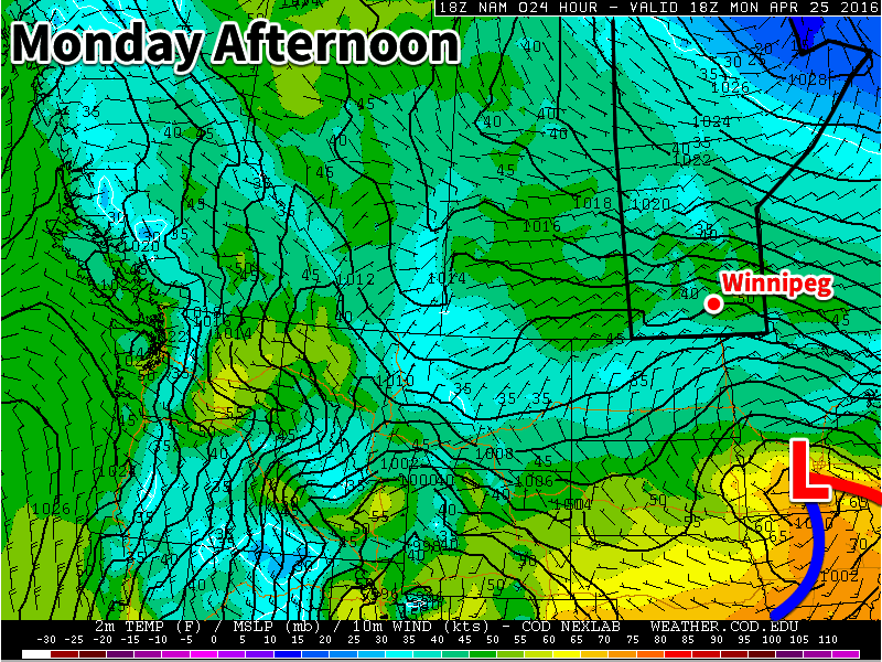
The coming 3 days will bring sunny skies to Southern Manitoba with seasonal temperatures and relatively light winds. Today and Saturday will both see high temperatures near 15°C with overnight lows in the 1-2°C range. Slightly warmer weather will move in on Sunday with temperatures climbing into the upper teens with daytime highs near 18°C. Winds will be out of the north to north-east today and Saturday, at 20-30km/h. With the warmer weather on Sunday, winds should be calm out of the northwest-to-west.

Staying Dry

While the mild, dry weather is pleasant for many people, with spring moving into full swing, the desire for a little rain will be increasing, especially from the agricultural community. Unfortunately for us, the odds of any significant precipitation over the coming week is slim.

NAEFS Probability of > 5mm of Accumulated Rainfall between April 29 and May 6, 2016

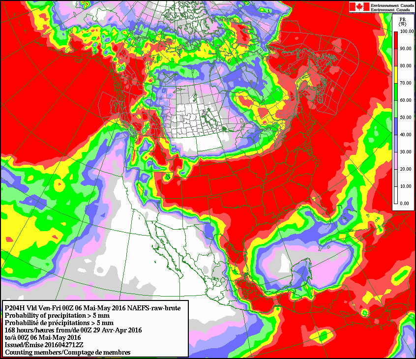
Looking ahead over the next week, the NAEFS is painting a dry picture. Above shows a probability of locations seeing a total of 5mm of rain or more through April 29 to May 5th. While it’s a foregone conclusion over the western and eastern Coasts, here in the middle it’s showing essentially a 0% chance of it. 2mm is also similarly bleak, with only a 30-50% chance.

This means that the odds of anything that might actually soak the ground at all is nil. Moving past next week into the 2-4 week period, it looks like we’ll head back towards a "seasonal" chance for precipitation, but no major soakers are on the horizon. Alongside the dry weather, however, will likely be some warmer weather as upper-level ridging gradually builds in over the region.

Winnipeg’s seasonal daytime high is currently 15°C while the seasonal overnight low is 2°C.

Quiet Weather with Near-Seasonal Temperatures Will Continue

The quiet weather Winnipeg has seen over the past several days will continue with dry conditions and near-seasonal temperatures continuing to the end of April.

The forecast for the remainder of the work week is brief! "More of the same" will be the mantra for Winnipeg over the coming days with daytime highs in the low teens and variable cloudiness. Today will bring just a few clouds to the Winnipeg region with breezy winds out of the northeast that strengthen to around 30km/h midday and persist into the evening. Tomorrow will bring more of a mixed sky with lighter winds, and Friday is looking like it will be a mainly cloudy day with light winds.

All three days will bring daytime highs in the 12-15°C range and overnight lows from 1-4°C.

Jet stream positions at 02:15Z April 27, 2016
This satellite image from last night shows the two jet streams impacting Manitoba.

This stagnant weather pattern over the region has been due to a stationary trough over the central United States coupled with a cut-off low over eastern Canada. As we head through the coming days, the trough over the US is will amplify and cut-off, becoming stagnant over the Northern Plains while the ridge builds in response, to the the point where it pushes all the way northwest into Manitoba.

This all means the overall pattern can’t change very much, and we see more of the same. The earliest indication of the potential for change is early next week when, if things turn out as forecast, an upper-level ridge may begin building in over North America, spreading above-normal temperatures through the Prairies.

Winnipeg’s seasonal daytime high is currently 15°C while the seasonal overnight low is 2°C.

Near-Seasonal Conditions Continue

This week will feature near seasonal temperatures and a brisk easterly flow as a stalled upper low sits to our south.

Today will be mainly cloudy, as a low pressure system to our south spreads clouds and showers over southern Manitoba. The main shower activity is expected to remain near the International border, though a few showers may creep a bit further north. Temperatures will be in the low teens with easterly winds at 20-30 km/h.

A low pressure system will sit to our south on Monday

Tuesday will be much the same as Monday, with temperatures in the low to mid teens under mainly cloudy skies. No rain is expected in the Red River Valley, though some light showers may occur in western Manitoba. Winds will be easterly at 20 km/h.

Wednesday will likely see a bit more sun, with skies being a mixture of sun and cloud. High temperatures will be in the mid teens with winds out of the east at 30 km/h.

Long Range

The long range forecast suggests that we will see more above seasonal weather as we move into May. The remainder of April will likely see temperatures around seasonal values, with highs in the mid teens.

Seasonal Temperatures Return For The Weekend

Winnipeg will see another cool day before seasonal temperatures return on Saturday and stick around through the weekend and beyond. Overall the upcoming weather forecast could be described as "fairly boring" with no significant weather events expected in the next 5-7 days.

Winnipeg will see mainly cloudy skies today as a weak upper-level disturbance moves across the province. With all the cloud and a weak northerly wind, below-normal temperatures will persist with a high temperature of just 7°C. The afternoon will bring a slight chance of some shower activity, but it is overall expected to be quite light and may remain north of the Winnipeg. Temperatures will be chilly tonight as temperatures dip to +2°C under cloudy skies.

Saturday will be another cloudy day in Winnipeg and mark the start of the next weather system that, while not directly impacting us, will set the stage for the weather over the region for the next few days. A fairly potent low pressure system will begin building out of Montana into South Dakota, spreading cloud and rain through North Dakota towards the Canadian border. A strong deformation zone should set up just south of the border, keeping the precipitation States-side. In Manitoba, this system will produce primarily cloud and wind. As mentioned, we expect mainly cloudy skies for Winnipeg, and much of the remainder of Southern Manitoba, on Saturday. The wind will pick up out of the northeast, strengthening to about 30km/h here in Winnipeg, with values closer to 40 gusting 60 km/h over southwestern Manitoba.

Some of the cloud will begin to slump to the south on Saturday night as temperatures drop to the -1°C mark.

GDPS Surface Wind Forecast valid 18Z Sunday April 24, 2016
A strong low pressure system (L) in South Dakota will bring windy conditions to the Red River Valley on Sunday.

Sunday will bring partly cloudy skies for Winnipeg as the main cloud shield slumps to the international border.[1] Temperatures will continue near seasonal values with a high of 10°C. Unfortunately, it will feel quite chilly as a brisk northeasterly wind approaching 40km/h develops over the Red River Valley. Temperatures will dip down to the freezing mark on Sunday night once again with winds tapering off.

A quick glance ahead into next week shows pretty much more of the same; some sun, some cloud, and temperatures at or just below seasonal. Not much is expected precipitation wise until a system comes through in the second half of the week and brings the potential for some rain to the region.

Winnipeg’s seasonal daytime high is currently 13°C while the seasonal overnight low is 0°C.


  1. This means that for areas in the southern Red River Valley, skies will likely be more mixed-to-cloudy.  ↩