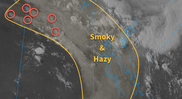
This week will start out with hazy skies from forest fires burning over Northern Saskatchewan and Alberta. There will also be a risk of thunderstorms today as a cold front moves through southern Manitoba.
Monday
Today will feature hazy skies, as extensive smoke from northern Saskatchewan/Alberta continues to pour south-eastward into southern Manitoba. The smoke will likely hold down high temperatures to the mid twenties, when they would otherwise be in the upper twenties. Despite the cooler temperatures, it is still expected that storms will develop along a cold front ahead of an incoming upper disturbance. At this point it appears that storms will be strong to marginally severe, with the highest potential for severe storms being in south-eastern Manitoba. The main threat with storms tomorrow will be large hail, although gusty winds are also possible. The main uncertainty surrounding tomorrow’s storm threat is how much the smoke will affect atmospheric (in)stability. If smoke is less extensive than expected, storms could potentially be stronger due to extra daytime heating.
Tuesday
Tuesday will be a nice day, with temperatures in the mid twenties under mainly sunny skies and light winds. There may still be some lingering smoke, but it shouldn’t be as extensive as earlier in the week. No precipitation is expected.
Wednesday
Wednesday will be another pleasant day in southern Manitoba. Temperatures will be in the mid to upper twenties under mainly sunny skies. Winds will be light once again and there is only a slim chance of showers.
Long Range
The medium-term forecast suggests we’ll generally see normal to above-normal weather for the next week or so. Beyond that it appears there may be slightly more unsettled conditions as we see more frequent chances for stronger weather systems passing through the region.
True summer warmth is on the way for Winnipeg with temperatures soaring into the upper 20’s and overnight lows in the mid- to upper-teens. However, alongside the warmer weather, multiple threats for severe thunderstorms will return to the region.
Friday
Friday
29°C / 17°C
Partly cloudy, chance of a thunderstorm
Today will be a very warm day with temperatures climbing into the upper 20’s and light winds. Skies will start off sunny, and then we’ll see some afternoon cloudiness develop over the valley alongside some scattered thunderstorms. There’s little organizational feature, so it will be rather hit and miss as to whether you see a thunderstorm where you are or not.
Further north and west, there will be a slight risk of severe thunderstorms. MUCAPE (a measure of instability) values of 1000–1500 J/kg coupled with 25 kt of bulk shear will be substantial enough to support the organization of severe thunderstorms. A mid-level disturbance will slump to the southeast into Parkland Manitoba and the Interlake by early- to mid-afternoon and provide a focus and trigger for thunderstorm initiation.
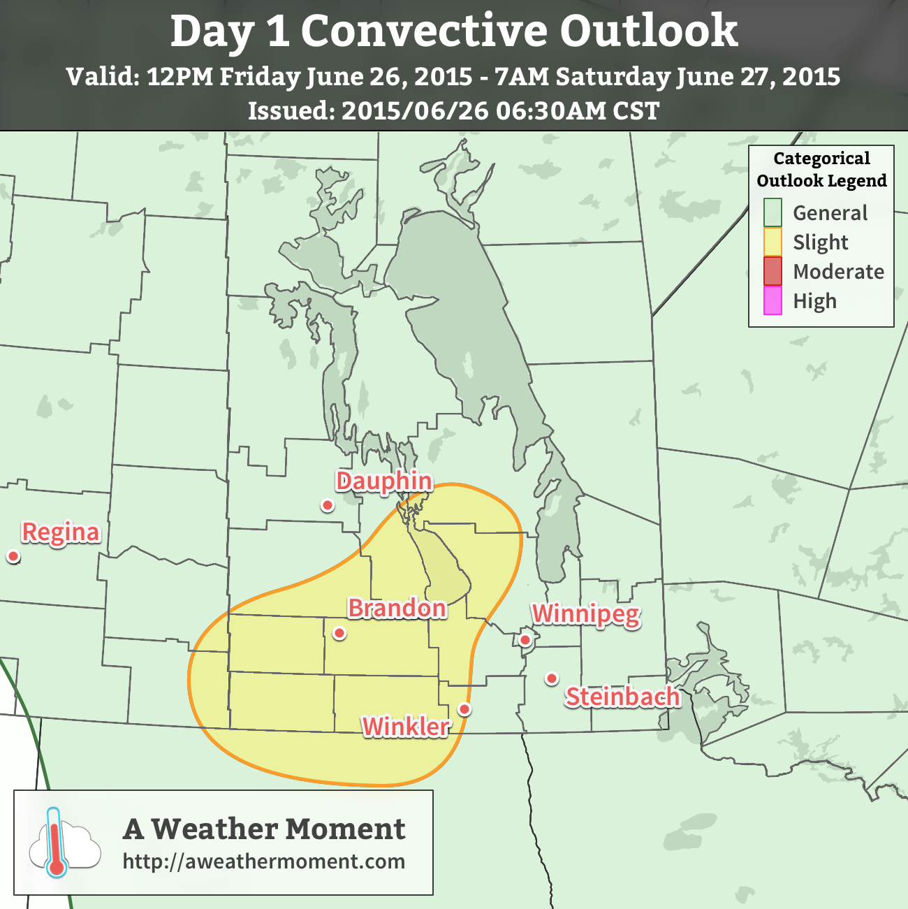
A slight risk of severe thunderstorms exists today over southwest Manitoba into the Interlake region.
Severe thunderstorms are not expected widespread, but isolated severe cells are possible. Over the western sections of the slight risk area, large hail and heavy rain will be the primary threats. Those threats also exist further east in the slight risk area – mainly along the Red River Valley escarpment into the Interlake – there will also be a slight chance for funnel clouds or weak landspout tornadoes due to the additional “spin” provided by a shortwave moving through.
Temperatures will remain quite warm overnight with lows dipping to just around 16 or 17°C.
Saturday
Saturday
27°C / 14°C
Mixed skies; risk of a severe thunderstorm
Saturday will see a severe thunderstorm threat return to Winnipeg as more humidity pushes northwards ahead of a significant shortwave and associated trough line approaching from Saskatchewan. Dew point values are expected to climb into the upper teens producing MLCAPE values over 2000 J/kg. Strongly veering wind profiles coupled with over 40 kt of bulk shear will result in a moderate severe thunderstorm threat. While some models show surefire convection, there may be issues with a capping inversion depending on exactly how warm it’s able to get.
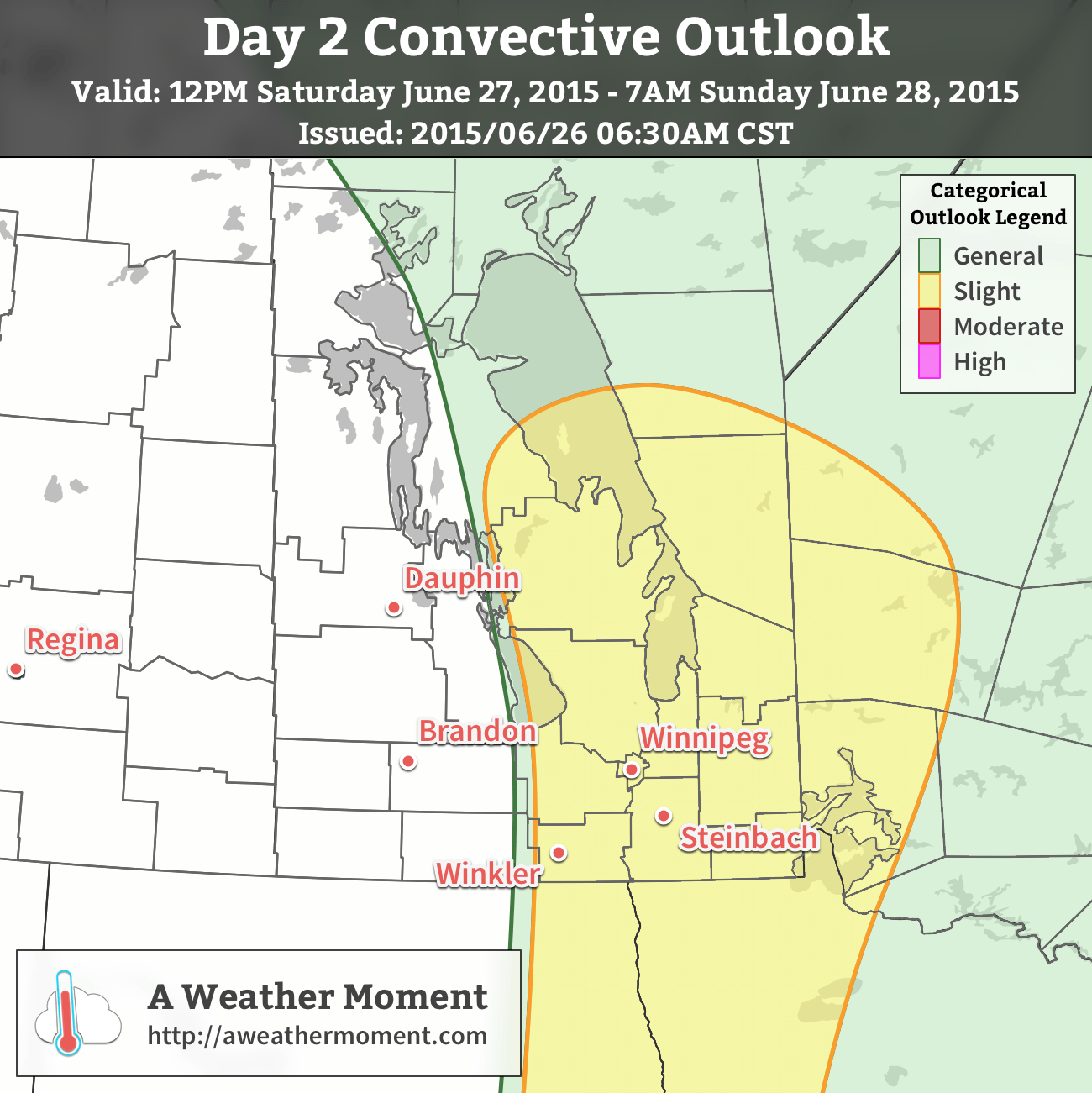
A slight risk of severe thunderstorms exists on Saturday through the Red River Valley, Interlake and eastwards to the Ontario border.
An updated convective outlook graphic is available in the comments below.
Given the uncertainty, a slight risk for severe thunderstorms exists on Saturday through the Interlake into the Red River Valley. As the issues with the capping inversion become clearer, the threat may be upgraded to a moderate risk.
The primary threat with storms on Saturday would be damaging hail, strong winds and torrential downpours. Shear profiles are supportive of supercells, and while it’s not considered a significant likelihood, it’s important to remember that supercell thunderstorms can produce tornadoes.
Regarding non-thunderstorm weather on Saturday, temperatures will climb into the upper 20’s which will feel more like the low- to mid–30’s with the increased humidity. The winds will be out of the south at around 20km/h. Skies should clear on Saturday night as temperatures drop to the mid-teens.
Sunday
Sunday
28°C / 15°C
Mainly sunny
Sunday will finally see both warm temperatures and quiet weather. Temperatures will climb back into the upper 20’s with winds out of the north at around 15–25km/h. With those northerly winds, the humidity will be quite a bit more comfortable than on Saturday.
Some thunderstorm activity will occur in Manitoba on Sunday, but it will most likely be constrained east of Lake Winnipeg & down into the northern Whiteshell. The thunderstorm activity does not look like it has an organized severe threat.
Expect temperatures to dip back to the mid-teens on Sunday night.
Winnipeg is set to see summer-like heat slowly build into the region over the coming week, however the unsettled weather brought about by the zonal flow that’s been in place over the past several days will continue doing its thing for another few days yet before more stable conditions build into Manitoba.
Today will be a similar day to yesterday with daytime highs in the low 20’s through the Red River Valley and fairly light winds. Dew point values are expected to climb to around 16 or 17°C today, which when combined with a bit of daytime heating will provide some fuel for scattered thunderstorm mid-day through the afternoon. Applying the MIST principles:
Moisture: As mentioned, dew point values are expected to rise to around 16 or 17°C thanks to some pooling along a weak trough through the region coupled with an easterly to southeasterly flow tapping into higher dew points to the southeast.
Instability: Moderate mid-level instability will be in place thanks to a shortwave moving through the region. CAPE values, driven largely by the favourable thermodynamics in place, will be in the 1000–1500 J/kg range.
Shear: Bulk shear of 25–35 kt will be marginally supportive of organized thunderstorms. Directional profiles will be somewhat anomalous, with easterly low-level winds backing to the northwest/west thanks to the approach of an inverted trough. End result is that, particularly through western Manitoba, storm motion will likely be quite slow, making rainfall accumulations a potential hazard with today’s storms.
Trigger: This may be the weakest aspect of today’s storms. A very weak frontal trough will be in place, alongside a weak upper-level shortwave and impinging inverted trough. Lack of any strong focus will likely be biggest inhibitor to widespread storm organization and will diminish the severe storm potential for the day.
With those factors taken into account, we’ll likely see scattered thunderstorms across much of Southern Manitoba today, however the threat for severe thunderstorms will be quite low with just an isolated marginal severe storm risk. The exception to the rule will be in the southwest portion of the province closer to the inverted trough. Shear profiles have strongly backed surface winds with a backing profile, making slow-moving storms more likely there. With adequate bulk shear to support & ventilate the storms, heavy rainfall is a heightened risk in that area due to slower storm motion.
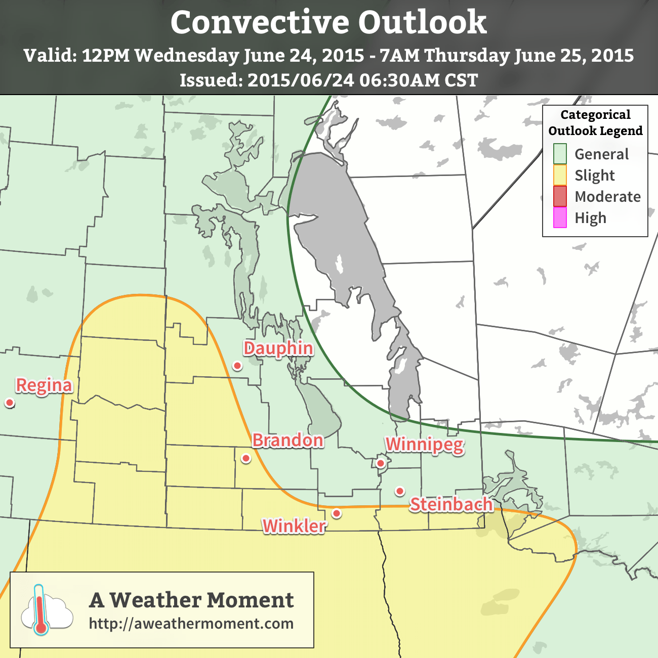
A slight risk of severe thunderstorms exists over SE Saskatchewan & SW Manitoba, extending eastwards along the international border.
That said, we’ll see mixed skies today alongside our chance for thunderstorms. Expect the storms to taper off this evening as we head to a low near 13°C.
Thursday will be off to an unsettled start as another disturbance rolls through the region and brings a chance for showers or thunderstorms through the morning hours. After that, we should see some clearing skies as the temperature heads on its way to a high in the mid–20’s. Expect clear skies Thursday night with a low near 14 or 15°C.
Friday looks gorgeous with sunny skies and a high near 27°C. Mainly clear skies should prevail Friday night with a low 12°C.
A Look Ahead to the Weekend
The weekend is looking like a bit of a mixed bag. The warmth will continue to build into the Prairies, particularly in the Western Prairies as the upper ridge begins building in. Here, Saturday looks potentially wet with the possibility of a low pressure system riding down the upper ridge through Southern Manitoba which would bring another batch of rain to the region. Sunday looks nice by all accounts with a fair amount of sun and highs climbing into the upper 20’s!
This week will start out with near seasonal temperatures, but somewhat unsettled conditions. Temperatures will be in the mid twenties, but there will be a frequent risk of rain or thunderstorms.
Monday
Today will start out rainy as upper disturbance produces precipitation over much of southern Manitoba. The rain should clear out of most of the province by the afternoon, except perhaps far eastern sections, leading to a breezy, but relatively pleasant evening. Wind will be north-west at 30 km/h gusting to 60 km/h.
Tuesday
Tuesday will be a mixture of sun and cloud with risk of thunderstorms during the afternoon and evening. Daytime heating will generate an unstable atmosphere across southern Manitoba, prompting storms to develop by the afternoon. These storms should be generally non-severe, although an occasionally severe storm with hail to nickel size may be possible.
Wednesday
It appears that Wednesday will be mainly cloudy with a risk of thunderstorms once again. Unlike Tuesday, storms are Wednesday should be almost exclusively non-severe due to very weak wind shear. There may be issues with heavy rain however, as storms will be slow-moving.
Long Range
The long range forecast looks general near seasonal for southern Manitoba. We will generally remain under the primary upper jet stream, meaning frequent chances for storms and/or precipitation.