Roller Coaster Pattern Setting Up

This week will feature wild swings in the weather. Conditions will range from warm to chilly to snowy, with the weather varying from one day to the next.

A low pressure system will bring light snow to southern Manitoba on Monday

A low pressure system will bring light snow to southern Manitoba on Monday

Monday

Monday

Chance of Snow Late
-10°C / -18°C

Today will be a bit cooler than the conditions we’ve experienced lately. High temperatures will be around the -10°C mark, with southerly winds. We’ll also see some snow begin to move into Western Manitoba from Saskatchewan in the morning or early afternoon. Total accumulations in Western Manitoba are expected to range from 2 to 5cm. The Red River Valley will be right on the edge of this area of snow, so we may end up with a couple centimetres if the snow pushes into the valley.

Tuesday

Tuesday

Decreasing Cloudiness
-11°C / -25°C

Tuesday will remain on the cooler side, though temperatures will remain near or slightly above normal. Highs will once again be near -10C, with a breezy north-west wind, but no precipitation is expected. We’ll cool down into the minus twenties on Tuesday night, but those cold temperatures will be short-lived.

Wednesday

Wednesday

Mainly cloudy. Chance of Flurries. Risk of Freezing Rain or Ice Pellets.
2°C / -18°C

By Wednesday a powerful low pressure system will send warm air cascading across the Prairies. The cold air from Wednesday morning will be scoured out from Southern Manitoba by the afternoon as temperatures rise above zero in most areas. However, this warm air will be accompanied by very strong winds. Southerly winds of 40km/h gusting to 60km/h in the morning will switch to westerly winds of 40-50km/h gusting to 60-70km/h in the afternoon. These warm temperatures should make the snow more difficult to blow around, though some blowing is possible in the morning before we warm up.

Some light snow will be possible on Wednesday in association with this low pressure system. Larger snowfall amounts will be possible if the system tracks further south than currently expected. In addition to the snow, there may even be a bit of freezing rain or ice pellets because that warm air may melt snowflakes as they descend from the clouds. Unfortunately, the cold front associated with this low will pass through on Wednesday night, sending in colder air for Thursday.

Thursday and Beyond

Warmer than normal weather is being forecast by the NAEFS model for the second half of January

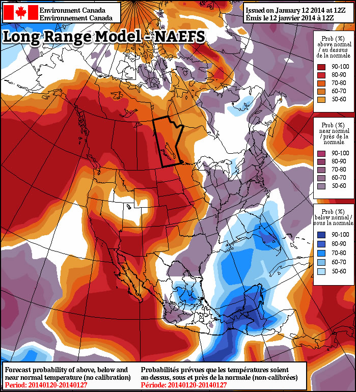
Thursday looks to be our coldest day for the next while, with high temperatures near -20C and gusty winds making it feel much cooler. However, besides Thursday It appears we will continue to see temperatures near or slightly above normal for the next while. Long range models continue to suggest that the second half of January will be warmer than normal, though we will still likely see the odd cold day here or there. No major weather systems are in the forecast, but this pattern will probably continue to send a parade of clipper systems coming out of Alberta, bringing the chance for light snow every few days.

Mild Weekend Welcome, But A Mixed Bag Otherwise

Temperatures over the next few days will be positively balmy for early January in Winnipeg as daytime highs near -5°C over the next few days keep us well over the normal high of around -13°C for this time of year. The warm temperatures are a welcome reprieve from the bitter cold that has gripped the province over the last month, but the other aspects of the weather will be a bit of a mixed bag over the next few days as multiple low pressure systems move through the region.

Friday
-5°C / -15°C
Cloudy with flurries beginning midday. Clearing overnight.
Saturday
-7°C / -12°C
Mixed skies and a bit cooler.
Sunday
-3°C / -15°C
Mixed skies with a chance of flurries in the morning and evening.

Today will be a pleasant day with fairly light winds and a high of around -5°C. Skies will remain cloudy through the day and we’ll likely see some scattered flurries develop through the Red River Valley midday as a very weak low pressure system pushes through. This evening will see any remaining flurries push off to our east with clouds scattering out overnight as we drop to a low of around -15°C.

Saturday will be a slightly cooler, thanks to a weak ridge passing over the Red River Valley, but nice day with a mixed sky and a high near -7°. We’ll drop only to around -12°C Saturday night as a warm front moves through the area associated with an incoming clipper system from Alberta. A band of light snow should push through the Red River Valley overnight into early Sunday morning with no real significant accumulations other than perhaps a couple centimetres here or there; the bulk of the snowfall will remain in the Interlake where around 2-5cm of snow is expected. Perhaps the bigger impact of the system will be the strong winds that move into the region on Saturday night; we’ll see them increase out of the south to 40 gusting 60km/h which will likely produce some blowing snow on highways throughout the Red River Valley.

After things clear out on Sunday morning we’ll actually be in for quite a nice day with a high near -3°C. Skies will be mixed for much of the day before more cloud moves into the area in the evening hours as a cold front slumps southwards towards the Red River Valley. The chance for some light flurry activity will re-emerge on Sunday evening with the passage of the cold front but as with the rest of the features this weekend, no significant amounts are expected.

Warmer weather is expected to continue through much of next week. A storm system is currently forecast to move through on Wednesday night, which could bring blizzard conditions to the Red River Valley thanks to very strong northwesterly winds, will likely bring cooler weather for the week’s end. We’re no longer in a relatively static upper-level pattern, though, so the cold air will continue trundling off to the east fairly quickly instead of sitting around here for a prolonged period.

The Deep Freeze Loosens Its Grip

After suffering through the 6th coldest December on record and a January that has seen all but one night drop below –30°C, a reprieve from winter’s icy grip is on the horizon as the upper air pattern finally shifts and allows some warmer air to spill eastwards into Manitoba.

Wednesday

-23°C / ↗ -16°C
Mainly sunny. Light snow with strong winds overnight.
Thursday

-8°C / -10°C
Light snow and strong winds tapering off in the morning then cloudy.
Friday

-3°C / -9°C
Mixed skies with chance of flurries in the evening.

Wednesday

Today will be the last sub-minus 20 day we’ll see this week! Our temperature will climb from our overnight low around –32°C up to around –23°C this afternoon under mainly sunny skies. We’ll see increasing cloud late in the afternoon or through the early evening as a warm front approaches from Saskatchewan. Temperatures will continue to rise overnight as the warmer air pushes into the province; we should rise to around –15°C by tomorrow morning.

In addition to the warmer air, we’ll also likely see some light snow move in with the cloud. The light snow will start overnight and taper off through Thursday morning. Amounts will be fairly minimal; here in Winnipeg we might see as much as a whopping 1–2cm while the southern Red River Valley will likely just see a few flurries with no significant accumulation.

Models are forecasting a very strong inversion over Winnipeg on Thursday morning; the large temperature contrast will produce very strong southerly winds.

The other significant weather tonight will be the increasing southerly winds. As the warm front approaches from the west, very warm air aloft will push into the Red River Valley. Temperatures at 850mb are expected to rise from around –15°C on Wednesday evening to close to 0°C by Thursday morning. With dense, cold Arctic air still in the Red River Valley, this strong temperature inversion will induce stronger winds than just the pressure gradient would imply. It’s difficult to pin down, but I think that we’ll see the winds pick up through Wednesday evening to 40–50km/h by Thursday morning with gusts as high as 60–70km/h. If things are able to completely decouple or the Arctic air is miraculously expedited out of the Valley very quickly, then we might see the winds remain calmer, somewhere between 20–30km/h; I don’t think this is particularly likely, though.

Thursday & Friday

We’ll see light snow slowly taper off on Thursday morning and then mainly cloudy skies thereafter. The winds will taper off through the morning to around 15–20km/h and remain there for the remainder of the day. Skies will remain mainly cloudy and we’ll see our temperature climb to a comparatively balmy (and warmer than normal) –8°C. Clouds will scatter out a bit on Thursday evening leaving us with partly cloudy skies and a low near –10°C.

More warm air pushes into the region on Friday as a low pressure system tracking through Central Manitoba drags another shot of warm air eastwards. Our temperature should climb to around –4 or –3°C under increasingly cloudy skies. Winds will be fairly light as well which will make it quite a pleasant day. Some light flurry activity is possible Friday evening and overnight into Saturday as we drop to a low near –10°C once again.

The Weekend

More warm weather is ahead for the weekend with daytime highs near –5°C on Saturday and possibly breaking 0°C on Sunday as a low pressure system winds up over the region, bringing potentially an inch or two of snow and a slight risk of some freezing rain. Mild temperatures continue into next week, so enjoy a nice break from the cold!

Light at the End of the Tunnel

We’ll have to deal with a few more days of frigid weather before a warming trend begins to take hold.

Extremely cold air will remain entrenched over Southern Manitoba today.

Extremely cold air will remain entrenched over Southern Manitoba today.

Monday

Monday

Mainly Sunny
-28°C / -32°C

Today will start out with extreme cold yet again. Low temperatures this morning will be in the minus thirties, though values will be closer to -30C than -40C. Afternoon temperatures will warm little, with temperatures “rising” into the upper minus twenties. Unfortunately, the wind will be quite a nuisance today, generating wind chills in the -40s once you factor in north-westerly winds of 20-30km/h. The mercury will plummet once again tonight, with lows in the minus thirties expected.

Tuesday

Tuesday

Mainly Sunny
-22°C / -30°C

Tuesday will be a slightly nicer day than Monday. The main improvement will be lighter winds, which will make it feel more like the actual air temperature. But those air temperatures will remain very cold, with highs once again being well into the minus twenties.

Wednesday

Wednesday

Mainly Sunny
-21°C / -25°C

Wednesday will remain very cold, with morning temperatures near the minus thirty mark, and daytime highs being near the -20C mark. The wind doesn’t look to be particularly strong, so like Tuesday it will feel close to what the air temperature indicates.

Warming in the Long Range?

The GFS model suggests we will see above normal temperatures by the end of the week.

The GFS model suggests we will see above normal temperatures by the end of the week.

The long range is where the light begins to appear in the tunnel. Models suggest that we’ll do better than -20C on Thursday as a warmer air mass begins to move into Southern Manitoba. However, this advancing air mass will be accompanied by strong southerly winds, which will cause Thursday to remain a fairly chilly day. However, by Friday into the weekend it appears that we’ll begin to see high temperatures consistently be in the low minus teens or minus single digits. Models don’t show any major cold snaps returning in the foreseeable future, but there will still be colder days here and there. The bottom line is that a prolonged period of warmer weather is finally on the way – time to pop the champagne!