Summer Returns!

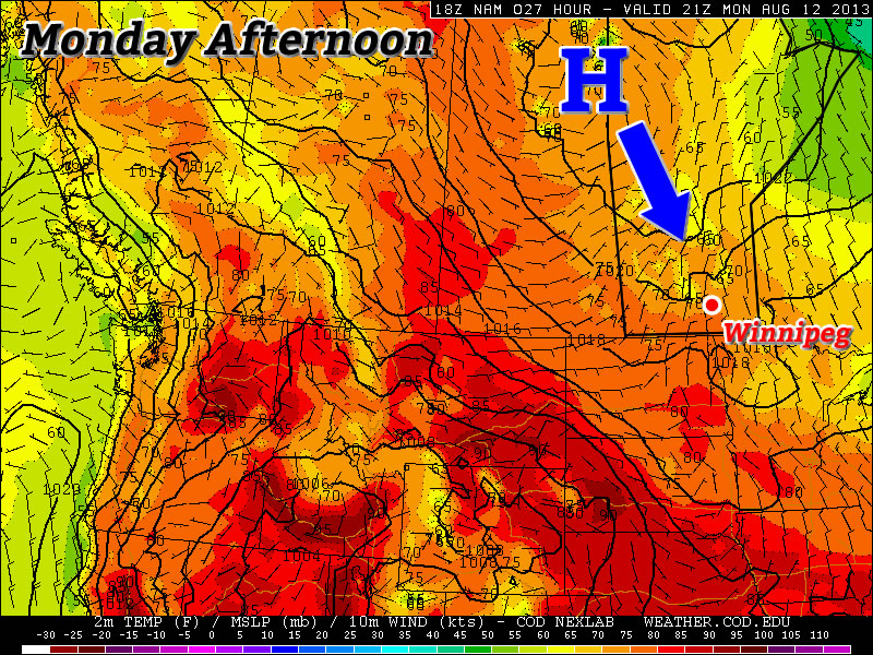
After weeks of below-normal temperatures in Winnipeg, we can finally rejoice as summer is set to make a significant return.

Wednesday

25°C / 13°C
Mainly sunny
Thursday

28°C / 14°C
Mainly Sunny
Friday

30°C / 17°C
Mainly Sunny

Describing the next few days will be short and sweet, we’ll see mainly sunny skies, a warm-up returning us to summer-like temperatures and increasing humidity as Gulf moisture is advected northwards in a southerly flow.

The only significant weather to speak of will be a slight chance of a shower or thundershower in the southwest Red River Valley on Thursday morning as a weak area of convection pushes through North Dakota. Other than that slight chance, things should be fairly dry through the rest of the week as well.

The Weekend

This weekend looks exceptinally summer-like as a humid, Gulf-sourced air mass entrenches itself over the Red River Valley. With temperatures in the low 30’s and dew points climbing to nearly 20°C, it’s going to feel more like it’s closer to 36 or 37°C. There will be a slight chance of showers or thunderstorms on Saturday night, but at this point the threat seems marginal at best. It looks to be a dry weekend for the most part with variable cloud cover.

After the weekend we move into a slightly dryer air mass, but the heat sticks around with daytime highs looking to be in the upper 20’s through most of the week.

A Return to Summer?

After several weeks of weather that resembled fall more than summer, we may begin to see hot weather return.

A Surface Ridge of High Pressure Will Slide Southward on Monday

Monday

Monday

Mix of Sun and Cloud. Slight Chance of Showers.
23°C / 6°C

However, before we see hot weather again in Southern Manitoba, we’ll have to deal with yet another burst of polar air. Another surface ridge will drop down from the north on Monday, which will result in reasonable, but still cool conditions. High temperatures on Monday will be in the low twenties, though there may be some readings in the mid twenties along the International border. There might be a few showers around during the afternoon and evening as cool air aloft generates a bit of instability. The wind will generally be light and from the north, though it will be a bit breezier in open areas.

Tuesday

Tuesday

Mainly Sunny
22°C / 7°C

Tuesday looks to be just a slightly cooler version of Monday. Highs will be in the low twenties once again with with a light northerly wind. Shower activity looks less likely on Tuesday, but there may still be some bubbly cloud cover as the ground heats up during the day.

Wednesday

Wednesday

Mainly Sunny
23°C / 10°C

At this point there is a bit of uncertainty as to how warm Wednesday will get. Some weather models suggest we’ll see temperatures in the mid to upper twenties, while others suggest temperatures in the low twenties are most likely. I’m leaning towards the later of those two scenarios, as I don’t think the warm air will move in quite that quickly. As a result, I’m once again calling for temperatures generally in the low twenties with variable cloudiness through the day. The area with the best chance of seeing some warmer conditions on Wednesday will be portions of Western Manitoba where that warmer air may filter in a bit during the afternoon and early evening.

Long Range

The longer range forecast is where things begin to look more promising. Models suggest that we’ll stand a good chance of seeing high temperatures in the upper twenties on Thursday. If we’re lucky, we may take a run at the 30C mark as early as Friday, but that type of heat looks more probable on the weekend right now. There have also been some hints in the models that this heat may also be accompanied by elevated humidity levels. Given that the model I’m looking at for this (GFS) is notorious for being too humid, I’m not going to get overly caught up on this for now. Once we get closer to the weekend, and more accurate information is available, this part of the forecast can be more appropriately addressed.

Weather Set to Slowly Improve

After a few days under the influence of significantly below-normal temperatures, conditions are set to gradually improve as the cold low that has been anchored over Northern Manitoba, Northwestern Ontario and Hudson Bay – for what feels like forever – begins to slowly shift off to the east.

Friday

21°C / 9°C
A few scattered showers in the morning, then a mix of sun and cloud.
Saturday

22°C / 11°C
Mainly Sunny
Sunday

24°C / 11°C
Mainly Sunny

This morning will start with mostly cloudy skies and a few scattered showers through the Red River Valley. These showers will taper off through the morning and should be over by midday. After that, we’ll see a mix of sun and clouds (although there’s a slight chance we might end up fairly cloudy, but I’ll bet on some sunshine) as we climb to a high of only around 21°C. We’ll have a partly cloudy sky tonight as we drop to a low of about 9°C.

Forecast for 700mb heights & winds from the RDPS valid this morning. The orange dashed line represents an upper trough swinging southwards that is expected to produce a few showers Friday morning.

Saturday and Sunday will be fairly nice days. Winds won’t make much of an appearance while much of our cloud cover finally moves off into Ontario and some warmer air finally starts to push back into the region. We may see a bit of a cloudy start to Saturday, but things should quickly turn sunny as we climb to around 22 or 23°C. We’ll drop to around 11°C Saturday night and then climb to a sunny high of 24°C on Sunday.

Moderation, At Last

The NAEFS 8-14 temperature anomaly outlook issued 12Z August 8th.

The NAEFS 8–14 temperature anomaly outlook issued 12Z August 8th. The lack of colours over Manitoba represents a return to seasonal weather is expected.

Long-range forecast models are finally forecasting a return to seasonal weather over the next week or two. With the relocation of the cold low into Eastern Canada, the persistent cold trough that drove our northwesterly winds will also vacate the region allowing milder air to push back in. Like we mentioned on Wednesday, no particularly warm is set to push into the area, but the warm August sun should quickly modify our air mass back towards seasonal values.

Little to no precipitation is expected in the next 5–7 days as broad upper-ridging slowly builds into the Prairies. A couple weak disturbances will have to be monitored, but for now there’s no rainy days in sight.

Fall Arrives Early

Distinctly fall-like weather will dominate over Southern Manitoba through the rest of the work week as a (unfairly) cold low slumps southwards into Central Manitoba, spreading cool Arctic air southwards across the Red River Valley and into the northern Plains of the United States.

A cold low slumping southwards into Central Manitoba will bring cooler, distinctly fall-like weather to Southern Manitoba. Image depicts 700mb temperatures for midday today.

A cold low slumping southwards into Central Manitoba will bring cooler, distinctly fall-like weather to Southern Manitoba. Image depicts 700mb temperatures for midday today.

Today & Tonight

Wednesday

18°C / 8°C
Mainly cloudy with a chance of showers.

We’ll see mainly cloudy skies today as the upper low continues it’s southwards trek pushing cool, unstable air into the Red River Valley. There may be some drizzle or a few showers to the in the lee of Lake Manitoba and the south basin of Lake Winnipeg this morning, although there may be enough wind shear to prevent any lake-effect precipitation from forming in this cool air mass. Temperatures will climb to only around 18°C today with some scattered showers developing through the day in most areas of the Red River Valley. The clouds and showers will move out in the evening leaving us with clear skies and light winds as we drop down to a temperature of around 8°C.

Thursday & Friday

Thursday

20°C / 11°C
Mainly cloudy with a chance of showers.
Friday

22°C / 9°C
Cloudy with a chance of showers in the morning then clearing.

Thursday will start off nice and sunny but quite cool. Scattered clouds will develop midday before a more organized area of cloud begins work it’s way into the city from the north in the afternoon. The afternoon cloud will limit our daytime high to only around 20°C. By late afternoon or early evening we’ll see a chance of showers move into the Red River Valley as another batch of moisture wraps around the back-side of the upper low and down through the Interlake. The cloud cover will help keep our overnight low a little warmer – close to 11°C – instead of the cooler temperatures of Wednesday night.

Early Friday morning we’ll probably see mostly cloudy skies with a chance of showers. The cloud cover will push out in the mid-to-late morning and we’ll be left with sunny skies and a high near 22°C. Friday night will be cloudy with a low of around 9°C.

Hope For the Weekend?

While some long-range models are forecasting temperatures in the mid–20’s, at this point it doesn’t look like we’ll see a warm-up that quickly. While the cold air definitely begins to push off to the east through the weekend, no particularly warm air is pushing in to replace it. We’ll see gradual warming thanks to the sunny skies, but at the moment a more conservative forecast of temperatures climbing towards the mid–20’s – instead of rocketing past it – is probably a safer bet. At this point it does look like it will be nice and sunny through the weekend, though, so all in all it will be quite pleasant.