Cooler Air Pushing Southeast Across Southern Manitoba

The powerful low pressure system that has brought rain to Winnipeg over the past couple days and is bringing 10-20cm of snow to portions of Northern Manitoba has pushed north and east of the Red River Valley, setting the stage for cooler air to filter into the region.

700mb Temperatures for Thursday Morning

NAM forecast of 700mb heights & temperatures valid Thursday morning.

The Red River Valley will be moving into a strong northwesterly flow aloft that will advect cooler air into the region. While earlier in the week, models were projecting a very potent arctic blast, things have become a little more pleasant due to a more significant amplification of the upper-level pattern. The net result of this is a cut-off upper low over the central Prairies that will, in effect, block the coldest air from being able to push southwards. This will give us more cloud than sun with daytime highs near 5 or 6°C through the rest of the work week.

The upper low begins to push eastwards for the weekend, allowing slightly cooler temperatures to the area for the weekend, with highs near 0°C, and a chance of some light snow. Accumulations will be light-to-none throughout the RRV, however a few cm may pile up in the Interlake region.

More Active Weather

More active weather is in store for this week with multiple chances for precipitation. The question is whether that precipitation will be solid or liquid.

Low pressure system passing to the south-east on Thursday

A low pressure system is currently expected to pass to our south-east on Thursday, generating minimal impacts in Manitoba

The weather to start the week will be fine, with temperatures generally in the high single digits on Monday and perhaps a few double-digit readings here and there. There will be increasing cloudiness during the day as a weather system approaches. This system will begin to spread rain over Southern Manitoba on Monday night with precipitation persisting into the day on Tuesday. Highs on Tuesday will remain very similar to Monday, but the rain will make it a considerably more miserable day. Total accumulations from this system will generally range from 5 to 15mm. As Tuesday’s system departs our region on Wednesday, cooler air will sweep in from the west making for a chilly and windy middle of the week. Temperatures on Wednesday will be in the mid single digits with a gusty west wind.

There has been much talk about the weather for later this week. Some models have been showing a significant Colorado Low system hitting portions of Manitoba on Thursday and Friday. However, other models show little or no precipitation for us later this week. At this point the consensus seems to be that it is unlikely Southern Manitoba will be getting a major blizzard later this week. Most models depict a moderate strength low system sliding past us through Minnesota and up into North-Western Ontario, perhaps bringing a few flurries or rain showers to Southern Manitoba, but not a major winter storm. Some models still show a fairly deep low pressure system to our east over Northern Minnesota and North-Western Ontario later this week, but it looks like it will be sufficiently far away to prevent us from seeing its main impacts. So at this point it appears unlikely that we’ll be seeing any significant amount of the white stuff later this week. However, expecting the unexpected as always a good saying to live by in the weather business.

Lingering Showers Give Way to Unsettled Weekend

A few lingering showers will persist through the Red River Valley this morning as the low pressure system that has been bringing us rain the last couple days slowly pushes eastwards. Conditions won’t improve too much, however, as we’ll be dealing with unsettled weather, albeit a little dryer, through the weekend.

Rainfall accumulations through the day today.

This 12 hour rainfall accumulation map shows the total rainfall that the RDPS model is forecasting for the daytime today.

Showers will slowly taper off through the Red River Valley today from west to east with only a further 2-4mm in rainfall accumulations. This system has brought hugely varying rainfall amounts across the RRV, with general amounts from 20-60mm across the Red River Valley. After spending several months in a row with below-normal precipitation, this system has pushed Winnipeg back to above-normal accumulations for October, which will begin to chip away at our deficit for the year. Winds will also taper off through the day today as we move to a high of only 7 or 8C.

Saturday will be a mainly cloudy day with a slight chance of showers and a high near 11C.

A frontal wave pushes across Southern Manitoba on Sunday, occluded from the parent low that will be captured over Northern Saskatchewan by an upper low in the area. Some uncertainty exists to the amount of precipitation associated with this wave as it moves through. Some models have next to no precipitation, while the GDPS is suggesting as much as 10-15mm of rain. My personal feeling is that we’ll likely see some rain push through with general amounts in the 4-8mm range across much of the RRV. We’ll keep an eye on this system and provide some updates through the weekend in the comments below. Sunday will likely be mostly cloudy again, with a high near 10C.

The biggest weather feature next week looks to be the potential for a significant low pressure system to push into North Dakota, bringing rain, snow, and potentially blizzard conditions to the Red River Valley for the second half of the week. That’s a long ways away, though, and a lot can change between now and then. We’ll be sure to follow this potential system closely through the week ahead.

Wet & Windy Weather On The Way

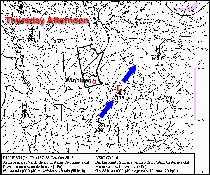
Yesterday’s beautiful mid-October weather will be replaced in a hurry today and tomorrow, as a intense 985mb low pressure system brings unsettled weather into the Red River Valley with strong winds moving across the area as the low pushes eastwards.

RDPS 3hr. QPF for this afternoon.

3-hour accumulated precipitation for mid-afternoon from the RDPS. Precipitation will be oriented in a band NW-SE ahead of the main surface trough.

Cloudy skies will be dominant over the Red River Valley over the next couple days. While temperatures are fairly mild this morning, and of note is how high our dewpoint has climbed, we won’t gain too much temperature-wise through the day today. Showers will push into portions of the Red River Vally & SE Manitoba this morning, however it’s likely that precipitation will be sporadic for any one location through the day today with fairly minimal accumulations. Conditions don’t look too favourable for drizzle today; you generally want saturated low-levels of the atmosphere with a sharp contrast into dry air immediately above the cloud deck for drizzle generation. Today, we’ll actually have dryer low-levels with a fairly moist atmosphere above, so it’s more likely that any light precipitation would be somewhat-evaporated rain, not drizzle. Temperatures will climb to 12 or 13°C today.

A band of steady rain will begin to push into the Red River Valley this evening as an area of strong frontogenesis1 on the northwest side of the 850mb low orients itself over the region. The band of rain looks to be fairly narrow, and positioning of it will be very sensitive to the positioning of the 850mb low. All areas in the Red River Valley will see some periods of rain tonight, however any locations that end up under this sharp band of rain will likely see 5-10mm of rain. Amounts remain low, despite the strong forcing, as this system, while energetic, is relatively low in moisture. Precipitable water values look to be only in the 20-25mm range, instead of the closer to 40-50mm range we look for for higher-accumulation rainfall events.

Winds will pick up overnight into Thursday as the Red River Valley moves into a strong pressure gradient on Thursday. Winds will climb to 40-50km/h with gusts up to 60km/h. Showers will be widespread through the Valley as general “wraparound” precipitation moves in on the backside of this system. Total amounts for tomorrow will generally be 4-8mm across the Red River Valley. The rain and wind will taper off tomorrow night as the system moves off towards the Great Lakes. Temperatures will drop down to 6 or 7°C.

Friday will be a slow recovery day, as the clouds will begin to break up a bit through the day. With skies remaining fairly cloudy with only a few breaks for sunshine, temperatures will end up fairly steady through the day; likely only around 8°C. Looking ahead to the weekend, it looks to be a fairly seasonal weekend with a mix of sun and clouds and highs near the seasonal 10°C.


  1. From the AMS Glossary: In general, an increase in the horizontal gradient of an airmass property, principally density, and the development of the accompanying features of the wind field that typify a front.