GDPS 850mb Temperature Anomaly valid 12Z Friday March 11, 2016

Short-Lived Cool Snap Gives Way to Potential Record-Breaking Warmth

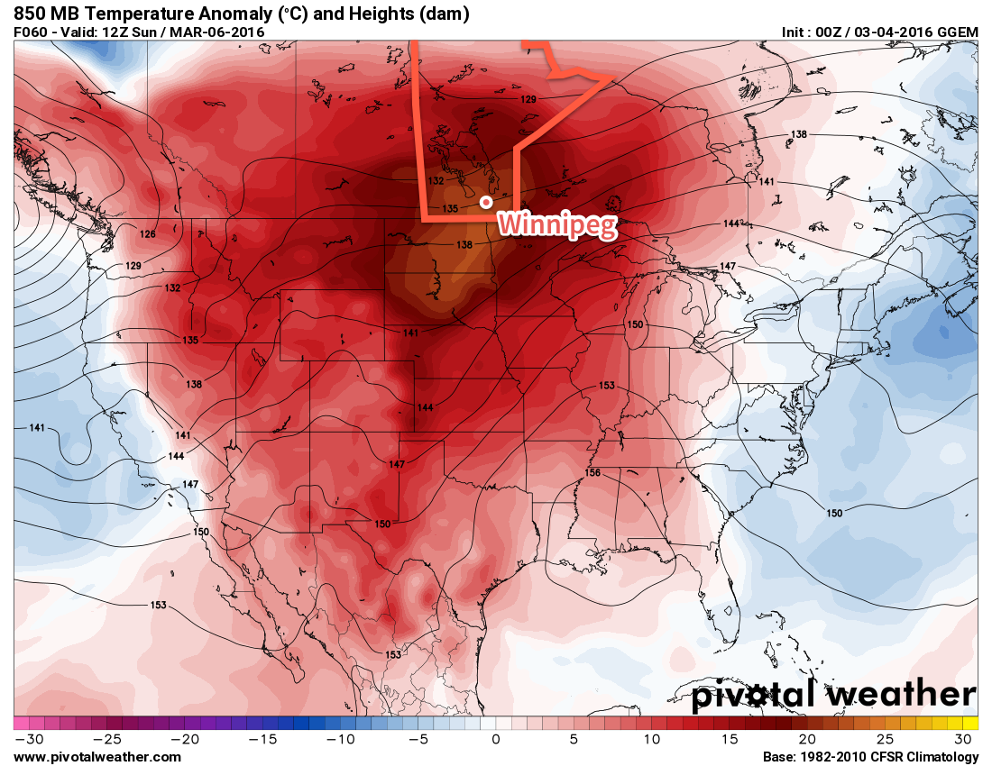
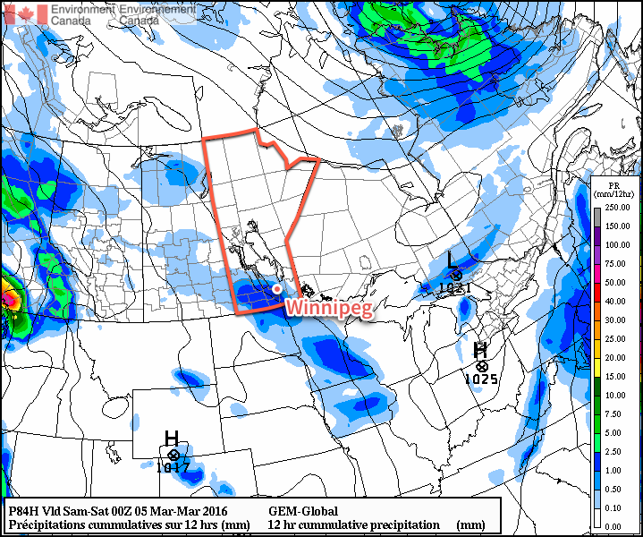
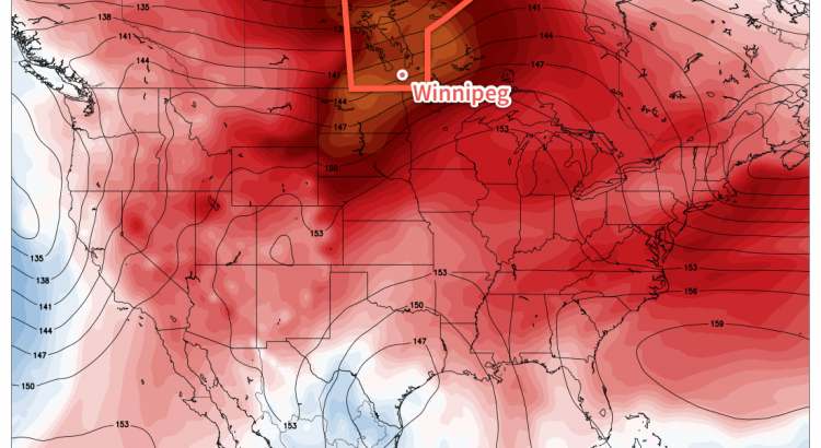
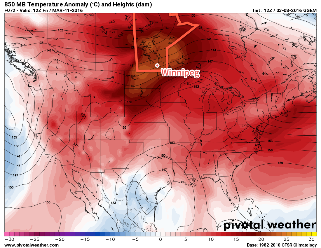
Temperatures will be cooler behind yesterday’s Colorado Low that grazed the southeastern portion of the province, however the mercury won’t be dipping much. Today will be the coolest day of the week and yet temperatures will still remain above seasonal for mid-March. The cooler weather will be short-lived before another surge of warm air that will bring spring weather to the Red River Valley, potentially threatening record high and record warm minimum temperatures!

Today will be a relatively cool day with the temperature climbing to the freezing mark with a light south-southeasterly wind. Skies will be mixed through the day with a bit of sun and a few cloudy periods, particularly mid-day into the afternoon. Much of the cloud will clear out tonight as temperatures dip to near -6°C.

After today, though, the heat starts moving eastwards and temperatures will soar to 10-15°C above normal for mid-March. Thursday will bring partly cloudy skies[1] and daytime highs climbing towards the 6°C mark with light southerly winds continuing. If temperatures manage to eke just a degree or so higher, there will be a chance of breaking Winnipeg’s record high temperature for March 20th.

Daily Record High and Record Warm Minimum Temperatures for Winnipeg, MB
Day Record High Record Warm Minimum
Thursday March 10 6.7°C (1902) 0.6 (1878)
Friday March 11 12.8°C (2012) 2.8°C (1878)

The mercury will dip to around 3°C on Thursday night with southerly winds strengthening to around 30km/h. This mild overnight low will set Winnipeg up for another potentially record-breaking day on Friday, where partly cloudy skies will give way to temperatures climbing into the low teens. The daytime high on Friday will likely sit near 11°C, however throughout the entire city the temperature could easily be in the 10-15°C range. The airport is typically on the cooler side, so it will be a bit of a nail-biter as to whether we break the record high of 12.8°C set in 2012.

GDPS 850mb Temperature Anomaly valid 12Z Friday March 11, 2016
The GDPS is forecasting 850mb temperatures over 20°C above normal for Friday morning.

Depending on how fast things cool off in the evening, we may also see the record warm minimum temperature for March 11 be broken as well. The record is currently 2.8°C set in 1878, which will require a temperature warmer than that through Thursday night and a temperature remaining warmer than than until midnight on Friday night.

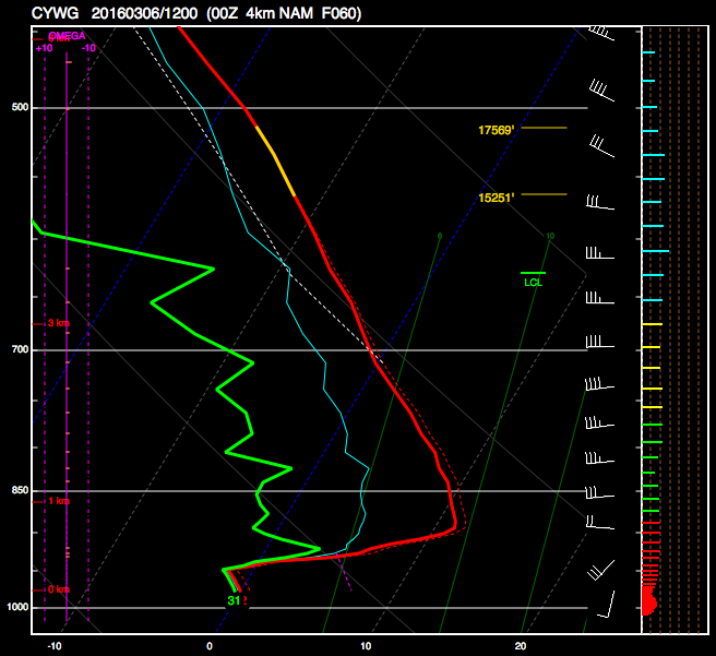
In addition to the warmth, of note particularly for Friday is the potential for unseasonably high dewpoint values. While the GDPS is fairly conservative with dewpoints remaining near the 1°C mark, several other models are showing dewpoint values rising into the upper single digits. There are two main stories if the elevated dewpoints do indeed show up:

  • We could break the record high dewpoint in Winnipeg for March 11, which currently sits at 6.0°C set in 2012.
  • There would be huge amounts of snow melt. The process of snow melt is limited when dewpoint values remain below 0°C for a variety of thermodynamic reasons. As the dewpoint climbs above 0°C, melting becomes significantly more efficient. By the time the dewpoint climbs to even +4 or +5°C, snow melt can be enormous if combined with mild temperatures. If these elevated dewpoints arrived for Friday with a high in the low teens, then almost certainly a dramatic portion of the remaining snow pack in the Red River Valley would be gone by this time next week.

Long Range: Warm, Warm, Warm!

The long-range forecast looks quite simple: continued warmth.

CPC 6-10 Day Temperature Probability Outlook valid March 14-18, 2016

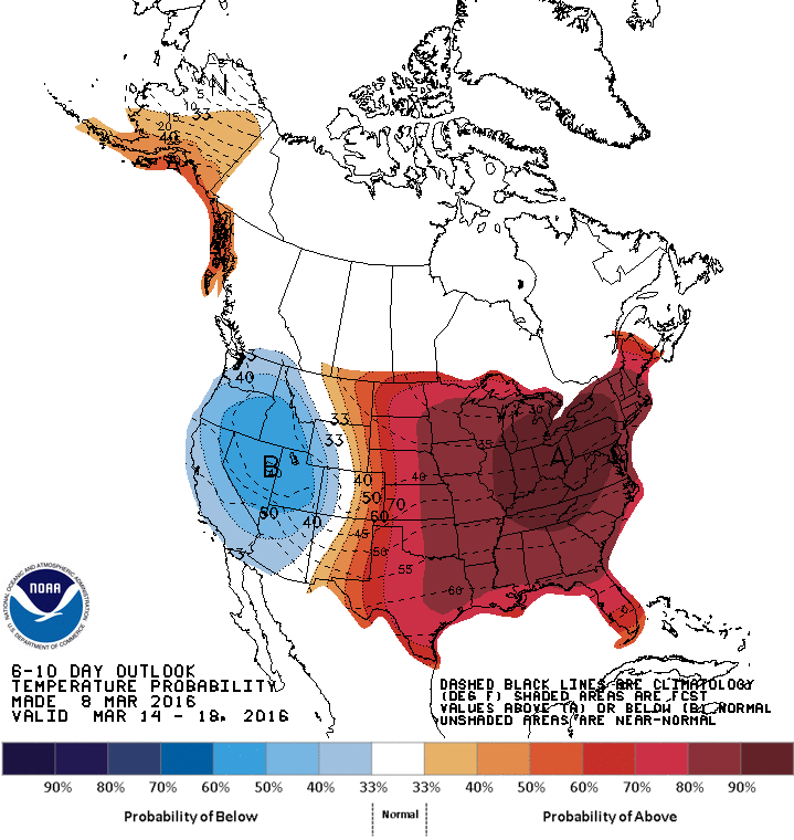
Long-range forecasts show a high likelihood of the mild weather continuing well into next week. This will mean that daytime highs in the 5-10°C range, if not even warmer, will be commonplace through the next week.

This warmth, combined with little-to-no expected precipitation through the period, will continue to rapidly erode the snow pack over the Red River Valley, further enabling milder temperatures to develop. Spring-like weather has arrived!

Winnipeg’s seasonal daytime high is currently -3°C while the seasonal overnight low is -13°C.


  1. There’s a slight risk of seeing cooler temperatures and more cloud if a system tracking through the Prairies slumps a bit further south, but at this point it looks like much of the cloud will remain to our north.  ↩

Mild Weather Continues

This week will remain mild with temperatures generally on the positive side of zero. However, there will be a chance for precipitation on Tuesday.

Today will see a continuation of Sunday’s warm weather. High temperatures will be in the mid single digits in the Red River Valley, and perhaps a bit higher over the snow-free area to our west. Skies over the Red River Valley will be a mixture of sun and cloud, while conditions over western Manitoba are mainly cloudy. The only wrinkle in today’s forecast is the potential for fog tonight, aided by the additional moisture generated by the snow melt.

A low pressure will pass to our south on Tuesday, bringing rain and snow to southern Manitoba. At this point it looks like precipitation over south-eastern Manitoba will primarily come in the from of rain. The Red River Valley will probably see a mix of rain and snow, while western Manitoba sees primarily snow. Large amounts of rain/snow are not expected, but models hint at the potential for localized bands of moderate precipitation which could bump up totals in some areas. Most areas will probably see 3-6 mm of accumulation, in the form of rain and/or snow.

RDPS MSLP & 3hr. QPF valid Tuesday morning.
A weak Colorado Low will bring precipitation to the Red River Valley on Tuesday.

Wednesday will be a slightly cooler day as a colder air mass surges southward behind Tuesday’s departing low pressure system. High temperatures will be near the freezing mark with breezy north winds.

Long Range

The long range forecast shows no indication of winter returning. Models strongly suggest that most, if not all, of March will be seasonably warm. Enjoy the snow now, it may not last much longer!

Snowy Friday Brings Return to Warmer Weather

A low pressure system moving through Manitoba today will bring a fresh batch of snow alongside some gusty southerly winds to Winnipeg and lead a transition back to a stretch of above-normal temperatures that will set up through the weekend and persist into next week.

Snow will be in place throughout the Red River Valley this morning and most places will see about 2-5cm of accumulation before it moves off to our east for the afternoon. In its wake, temperatures will rise under cloudy skies to our daytime high near -2°C.

Through the morning, winds will be out of the south-to-southeast at 20-30km/h, but will taper off as the snow pushes off to the east.

The big question for the remainder of the weekend is exactly how warm it’s going to get. And, unfortunately for some, I’m leaning on the pessimistic side.[1]

GDPS Forecast 850mb Temperature Anomaly
GDPS forecast 850mb temperature anomaly valid Sunday morning

Heading into the weekend, significantly milder air will be pulled eastwards across the Prairies, but the big question is how warm will it get? This isn’t quite so easy to answer for a variety of reasons, but one of the biggest being the snowpack in place over the region.

The GDPS is forecast temperatures at 850mb, approximately 1.5 km above the ground, to climb to nearly 20°C above normal for this time of year. Typically temperatures at 850mb can be used as guidance for daytime highs and overnight lows, however that relationship can be complicated in the winter time. As warm air moves in, the snow at the surface cools it and helps develop an inversion.[2] Inversions work to isolate the surface from the warmer air moving in, and can result in very warm air aloft not making it down to the surface.

Forecast Sounding for Winnipeg valid Sunday morning

This is a forecast sounding, which shows the forecast of temperatures (red) with height (up is higher) for a specific location. The inversion is fairly clear and is depicted by the area near the bottom where the red line moves to the right instead of the left. This will likely result in our temperatures being lower than some automated forecasts may suggest.

The overall weather pattern through the weekend will be a steady flow of warm air aloft interacting with a dynamic surface pattern. Saturday will start with cooler temperatures near -11°C and mainly cloudy skies trapped underneath a ridge of high pressure that will slide off to our southeast. It will likely be a cloudy day as low-level cloud is reinforced by cool outflow from the high pressure system trapped beneath the inversion of the warmer air aloft.

As a low pressure system begins tracking eastwards across the Prairies, it will help moderate winds develop over the Red River Valley. By mid-to-late afternoon on Saturday, winds will strengthen to 30-40 km/h out of the south as the temperature rises to -1°C. The winds will strengthen slightly for Saturday night to 40 gusting 60 km/h. These stronger winds will persist much of the night under cloudy skies and help the temperature remain steady near 0°C.[3]

Sunday will see the winds drop off in the morning and the Red River Valley move solidly into the warm air. While skies will likely start cloudy, some sun should begin poking out for the afternoon as the winds pick up a southwesterly component and start mixing some drier air into the valley. Daytime highs look to climb to the 4°C mark with overnight lows dipping to just -1°C under partly cloudy skies.

Long Range: Continuing Warm

There’s no question about it: the warm weather will be the dominant weather story for the coming 10-14 days.

NAEFS 8-14 Day Temperature Anomaly Forecast — Valid March 11-18, 2016

El Niño is back with a vengeance as above normal temperatures are expected to sweep across much of southern Canada and the United States. It’s hard to say exactly how warm it will get, but for Winnipeg it seems quite likely that daytime highs above 0°C will become quite commonplace over the coming weeks.

Precipitation outlooks are for near-normal amounts, so the odd disturbance giving us a couple cm of snow or a few mm of rain should be expected. Get ready for sloppy roads, warm sun, and suspension-shattering potholes.

Winnipeg’s seasonal daytime high is currently -4°C while the seasonal overnight low is -14°C.


  1. Which I’m relieved to say is still above normal for this time of year!  ↩
  2. An inversion is when temperatures behave abnormally with height in the atmosphere, rising with height rather than falling.  ↩
  3. There’s a slight chance with some of the stronger winds that the could be some bursts of warmer air through the night that could see temperatures climb to +2 to +3°C.  ↩

Temperatures Creep Back Towards Seasonal

Benign weather is in store this week for Winnipeg with temperatures gradually returning towards seasonal values. The weather will become more active heading towards the weekend as warmer weather begins pushing eastwards across the Prairies and returns above-seasonal temperatures to the region.

Today will be a pleasant day with mixed skies courtesy a weak system passing through southwestern Manitoba. Winds will be fairly light at just 10-20 km/h. The daytime high will climb to about -8C then drop to -19C tonight as skies clear. As a note, it will likely be considerably cloudier in the SW RRV and through southwest Manitoba as a thicker layer of cloud remains in the region.

Thursday will bring sunny skies, light winds, and a high near -9C. On Thursday night, some cloud will begin moving into the Red River Valley ahead of an incoming low pressure system, resulting in slightly milder overnight lows. Temperatures are expected to dip down to about -15C.

GDPS 12hr. Precipitation Totals valid 00Z Saturday March 5, 2016
The GDPS is showing light snow for Friday in the Red River Valley.

On Friday, a low pressure system sliding along the international border will spread an area of light snow from Saskatchewan east-southeastwards through SW Manitoba and the Red River Valley. It currently looks like snow will push into the Red River Valley in the morning and taper off by evening, with 2-4cm of new snow possible.

Temperatures will return to seasonal values on Friday with a daytime high near -5°C. Skies will clear through Friday night as temperatures head to a low near -12°C.

Long Range: Mild Weather Returns

A strong signal of a return to milder weather is showing up once again for much of Eastern North America

A major pattern shift will allow unseasonably warm air to spread back across much of the continent beginning this weekend and persisting through next week, driven by a collapse of the major west coast upper ridge that’s been in place for the past few weeks and the development of a zonal upper-level flow across much of the continent.

This flow will favour warm temperatures with daytime highs likely at or above 0°C here in Winnipeg for much of next week. These flows do typically bring more numerous disturbances through, so while temperatures will be mild, there’s a good chance that we’ll see more chances for rain or snow as well.

Winnipeg’s seasonal daytime high is currently -5°C while the seasonal overnight low is -15°C.