The heat is on the way to Southern Manitoba as warmer air finally spills eastwards bringing positively summer-like weather to the area.
There is astonishingly little to say about the coming few days. Temperatures will climb into the mid–20’s Friday, Saturday and Sunday with overnight lows near 11 or 12°C all 3 days. Winds will be fairly light with the slight possibility of some breezier conditions on Saturday afternoon, but even there it would only likely be 20–30km/h. No precipitation is expected, although there will be a slight chance of some showers on Saturday north of Winnipeg along a very weak cold front from Dauphin eastwards across the Interlake.
All in all it will be a perfect weekend to get outside either here in the city or head up to the cottage for a truncated mulligan of the May long weekend!
Uncertain Start to Next Week
The beginning of next week presents another interesting forecast challenge as yet another Colorado Low forms and pushes northwards into the Dakotas. Model forecasts currently diverge quite a bit, demonstrated easily by the current forecasted storm-total precipitation for Winnipeg produced by each one:
Forecast Storm-Total Precipitation for Monday’s Colorado Low
Model
Storm-Total Rainfall (mm)
GDPS
16
NAEFS
8
GFS
0
In general, amounts increase to the south and east of Winnipeg in all the forecast scenarios. Why the big difference? The track of the Colorado Low will depend significantly on how it interacts with thunderstorm activity that develops through the Central Plains as it ejects northeastwards from Colorado. If the convection forms close to the upper-level low and has a significant amount of moisture wrap into it, it will strengthen more, tilting the entire upper-level trough and pulling the system further northwest. If the moisture from the convection pulls off to the east over the upper-level ridge, then the system will be a bit faster, weaker and further southeast.
At this point, there’s still far too much disagreement in the models to make much of a forecast. Overall, the GDPS – currently forecasting the highest amounts for Winnipeg & the RRV – tends to produce too much convection and over-develop lows. They’ve made significant improvements in the latest version of the GDPS, but it still tends to have that strong bias which results in slower systems further to the NW. I think the GFS solution of nothing at all to likely be missing the mark and not quite worth banking on.
That leaves us with the middle-of-the-road answer. Likely some rain on Monday, however not likely as much as advertised by some weather sources right now. We’ll certainly keep an eye on things as they develop and have some updates later in the weekend on how it looks like things are developing.
But for now, get out there and enjoy the hot & dry weather!
A quiet week is ahead weather-wise as an upper-level ridge over the region dominates the weather for the remainder of the week. No precipitation is anticipated for the rest of the work week while temperatures slowly climb to above-normal values.
Wednesday
19°C / 4°C
Sunny
Thursday
20°C / 9°C
Sunny
Friday
24°C / 12°C
Partly cloudy
The next few days will be mainly sunny with just a few more clouds working in on Friday. No rain is expected. Daytime highs will start near 19°C today and climb to 24°C by Friday. Overnight lows will remain chilly tonight with lows just near 4°C, but then push towards above-normal of 9–12°C.
Long-Range Outlook
Overall, the weekend is looking quite nice. Temperatures will be in the low-to-mid 20’s with overnight lows in the upper single digits. Some showers or thunderstorms will be possible along a weak cold front draped across the province – likely north of Winnipeg through the Interlake – but at this point anywhere along or south of the Trans-Canada Highway looks fairly dry.
Heading into the start of next week, though, some models are hinting at the possibility of another – albeit weaker – Colorado Low impacting southern Manitoba. The GDPS[1] is forecasting a very rainy Monday with elevated convecting drenching Southern Manitoba with over an inch of rain. The NAEFS[2] takes a more middle ground approach and pushes a weaker system a bit further east, with our region being grazed and getting something in the 5–10mm range. The GFS[3] produces the weakest solution with an even weaker low pushed even further east with little-to-no impact on Southern Manitoba.
It’s too early to say too much about that system other than we’ll be sure to keep an eye on it as we head into the weekend. There are numerous factors which make it look not nearly as bad as the storm we had over the long weekend, so even though it may be the 3rd Colorado Low in 2 weeks, it may not be a significant issue for the region.
Global Deterministic Prediction System – The Canadian long-range forecast model. ↩
Southern Manitoba was slammed by a powerful Colorado Low this past weekend that brought a wide array of severe weather to the province. Between heavy rain, ice pellets, snow and very strong winds, the storm wreaked havoc on the regions infrastructure with widespread damage to trees, power outages, closed highways, structural damage and overland flooding.
The system was, fortunately, well forecast by Environment Canada with fairly accurate forecasts issued in the days leading up to it alongside special weather statements addressing the numerous impacts the system may have on the region.
Significant Rainfall Began Saturday Afternoon
Fortunately, the weather was able to hold for much of Saturday. Temperatures climbed into the low 20’s across Southern Manitoba with increasing cloudiness. Rain & thunderstorms developed through North Dakota & Montana and lifted northwards through the day, first spreading into SW Manitoba in the afternoon and then eastwards and northwards through the evening and overnight period.
Acres of flooded farmland between Winnipeg & Portage la Prairie. Photo via @CTVNewsBen.
Twitter user @AxeHaft snapped this picture of flooded farmland near Altona, MB.
Overland flooding at the cottages in Albert Beach, MB. Photo via @lovestormsMB.
Overland flooding near Oak Bluff, MB. Photo via @AnitaAnseeuw.
Some of the hardest hit regions were in SW Manitoba where hours of training thunderstorms & convective showers produced moderate to heavy rain. The Melita region was hit the hardest with 72mm of the grand total 90mm of rain falling by midnight on Saturday night. For areas further east, through, much of the rain fell through Saturday night & Sunday. Total rainfall amounts for Saturday and Sunday combined were:
Rainfall Totals for May 16–17, 2015 – Environment Canada & Manitoba Agriculture (*) Stations
Location
Rainfall Total (mm)
Melita
90
Bede*
83
Gretna
63
Carman
60
Deloraine*
57
Deerwood
55
Morden
51
Kleefeld
48
Reston*
48
Dugald*
45
Pilot Mound
44
Emerson
43
Pierson*
43
Letellier*
41
Winnipeg (Forks)
41
Portage East*
40
Portage Southport
40
Woodlands*
38
Oak Point
37
McCreary
36
Winnipeg Airport
36
Pinawa
36
Great Falls
34
Carberry
33
Sprague
32
Virden*
30
Brandon
29
Fisher Branch
29
Cypress River
28
Glenboro*
27
St. Pierre*
25
Wasagaming
24
Dauphin
22
Teulon*
21
Killarney*
20
Wawanesa*
20
Minnedosa*
17
Eriksdale*
16
Roblin
16
Souris*
15
Berens River
14
This rainfall is in addition to the 25–50mm of rain many areas in the region saw just a couple days prior to this storm. There were several areas that saw significant overland flooding due to the sheer quantity of water that fell over the short time frame.
Additionally, there were reports of sewage back-up and spotty basement flooding across Winnipeg.
Then Came the Wind
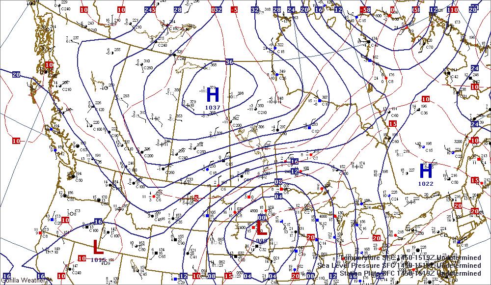
Sunday is where the brunt of the storm impact was felt. As the main low pressure centre lifted northwards into the Dakotas, a strong 1037mb high pressure centre was building into the central Prairies.
This surface analysis for early Sunday morning shows the strong low in the Dakotas and the strong high building into the central Prairies.
These systems produced a strong pressure gradient over southern Manitoba and produced some of the strongest, longest-duration winds for a major storm in recent memory. Winds were in excess of 50km/h for 20 hours in Winnipeg with a 6-hour stretch beginning late Sunday with winds of 60km/h or greater. Very strong gusts also accompanied the winds with Winnipeg recording the highest wind gust at 93km/h:
Peak Wind Gusts for May 17, 2015
Location
Peak Wind (km/h)
Time (CDT)
Winnipeg
93
6:44PM
Gimli Harbour
89
9:38PM
Carberry
87
4:57PM
Brandon
83
10:00AM
Kleefeld
81
4:14PM
Cypress River
81
5:01PM
Pilot Mound
81
2:45PM
Gretna
81
2:28PM
Melita
80
6:11PM
Emerson
80
4:21PM
Gimli
80
4:21PM
Porgae la Prairie
80
4:51PM
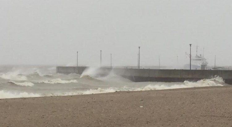
The winds may have been the most significant impact from this storm. The strong winds resulted in havoc on the highways, property damage, hundreds of downed trees, and widespread power outages. The strong winds also produced significant wave action on Lake Winnipeg and some overland flooding as rising lake levels resulted in the lake overspilling its banks and pushing inland in some locations.
Large tree snapped by strong winds in Winnipeg at Corydon & Nassau. Photo via @MattCundill.
Large tree down in Winnipeg Beach on Spruce Ave. Photo via @SeanLedwich.
High waves due to the strong winds associated with this weekend’s Colorado Low in Gimli, MB. Photo via @OlleBear.
A semi-truck blown by strong winds blocking the Trans-Canada Highway into Portage la Prairie. Photo via @ctvwinnipeg.
Strong winds ripped the roof off of The Bridge Church in Winnipeg, MB. Photo via @CTVNewsBen.
Photo of a downed tree in Winnipeg, MB. Photo via @mikki_co.
Winds tapered off to 40 gusting 60km/h on Sunday night, but remained fairly strong until tapering off Monday afternoon.
Oh, Snow Too
If the rain and the wind wasn’t enough, cold air moving in with the high pressure system resulted in precipitation switching over to ice pellets then snow beginning over Parkland Manitoba and then spreading southeastwards through the Interlake, Red River Valley & Whiteshell through the afternoon and evening. Areas through the Interlake southwestwards towards the Melita region saw the heaviest snow, with MacGregor reporting the highest amount of snow at 15cm. Amounts of 10–15cm were seen from Arnes, on the western shores of Lake Winnipeg, through Teulon, MacGregor, Treherne and down towards Boissevain:
Snowfall Totals for May 17–18, 2015 – EC Spotters & Social Media
Location
Snowfall Total (cm)
MacGregor
15
Teulon
15
Arnes
10
Boissevain
10
Treherne
10
Hollow Water FN
5
Albert Beach
5
Dauphin
5
Deloraine
5
Wasagaming
5
Winnipeg
3
In Winnipeg, we saw just a few cm of snow on Friday evening and overnight. Flurries persisted through Monday but temperatures were warm enough to prevent any more accumulation.
A damaged fence alongside substantial snow accumulation in MacGregor, MB. Photo via @JBMEquiFarms.
Substantial snow accumulation near Teulon, MB. Photo via @TrishG27.
MODIS satellite imagery showing the snow swath through the southern Interlake. Photo via @robsobs.
A broken tree sits atop a damaged structure in Dunnottar, MB amidst a fresh coat of snow. Photo via @alan_tabak.
All in all, this was certainly one of the most powerful storms Southern Manitoba has seen in a good long while. Perhaps the best thing that can be said is that at least it happened now and not a month earlier, where almost certainly it would have been a historic blizzard.
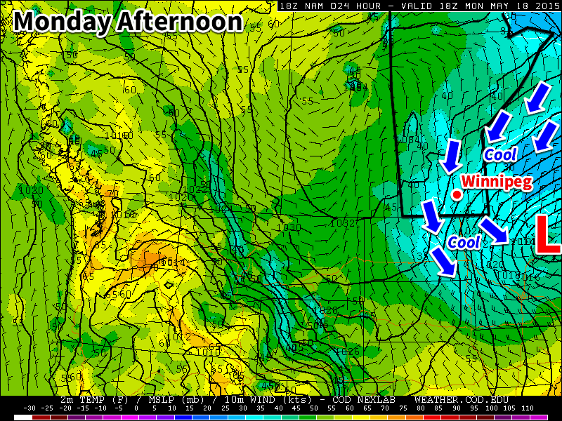
This week will start off on the cool side as a brisk northerly flow builds in behind this weekend’s Colorado Low. Temperatures on Monday will be downright chilly for mid-May.
Cool weather will dominate southern Manitoba on Monday
Monday
We’ll see skies gradually clear today as the system that brought us rain (and snow) this weekend departs. It will remain very chilly though, as temperatures barely climb into positive values. Daytime highs will only make it into the low to mid single digits, which should hopefully be enough to melt a good amount of the snow that fell. Winds will be northerly at 40 km/h gusting to 60 km/h, but will taper off throughout the day as the system pushes further off to the east.
Tuesday
Tuesday will remain on the cool side, but should be a fairly pleasant day (at least relative to the weekend!). High pressure will build into the region behind the weekend’s low pressure system, bringing much calmer conditions. High temperatures will climb into the teens under mainly sunny skies and light winds.
Wednesday
Wednesday will be quite nice as temperatures climb into the upper teens under mainly sunny skies. Winds will be relatively light and from the north-west, making for another pleasant day.
Long Range
The long range forecast shows conditions remaining slightly below normal through the end of the work-week. There are hints that we’ll see warmer conditions build in by the weekend, but it’s too early to say for sure. In general, models show us transitioning to a generally warmer pattern toward the end of the month, although there will still be some cooler days mixed in here and there.