Warm weather will stick around until Christmas, a nice break for the holidays.
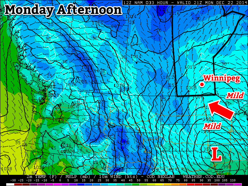
Mild conditions are expected in southern Manitoba on Monday
Monday
Monday
0°C / -4°C
Light snow
Today will be very mild, but with some snow. A low pressure system off to the south will generate some light snow in southern Manitoba during the day, with accumulations of generally around 2cm expected. Given the mild temperatures, most snow should melt quickly off treated roads, making for mostly wet, as opposed to slippery, conditions.
Tuesday
Tuesday
-1°C / -8°C
Light snow
More light snow is expected on Tuesday as the system to the south remains in place. Accumulations of around 2cm will once again be possible. Temperatures will remain mild though, making for a decent day.
Wednesday
Wednesday
-3°C / -10°C
Mainly cloudy with chance of flurries
A slight chance of flurries will linger on Wednesday, but any additional accumulations should be small. A breezy south wind will develop, keeping temperatures mild.
Long Range
Conditions should remain mild until Christmas, but after that a major pattern change is coming. Models suggest that our first major arctic blast in several weeks will move in on Boxing Day. That might have many folks doing their post-Christmas shopping online, as opposed to venturing out into an unfamiliar chill.
The NAEFS is predicting below-normal temperatures in the 8-14 day time period.
Snow Squalls Paralyze Several Japanese Prefectures
This week’s Elsewhere in Weather News focuses on western side of the Japanese islands of Hokkaido and Honshu which have seen significant amounts of snow from a snowstorm that hit midweek.
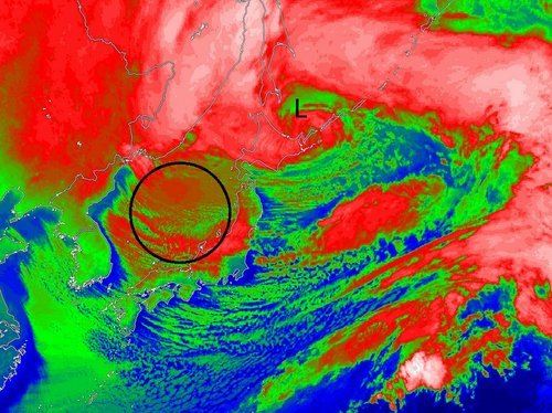
An area of low pressure which was moving northeast along Japan’s west coast quickly deepened to a 949mb low and whipped Japanese islands with winds of 60 to 100km/h. These winds, combined with widespread amounts of 20-30mm of rain ahead of the system. By the time the low reached the northern islands of Japan, strong northwesterlies kicked in over Japan’s main island of Honshu. Cold Siberian air infiltrated in over the Sea of Japan behind the low which stalled out, creating prime conditions that would sustain the development of snow squalls for a long period of time.
IR Satellite image of the mature low pressure system over northern Japan with circled area showing snow squalls forming over the Sea of Japan.
Snow squalls occur when cold air moves over a warm body of water, creating an unstable temperature profile. With the instability in place, snow squalls were able to from over the Sea of Japan and make their way to the western side of Honshu. Orography – the effect that terrain has in creating localized impacts on the weather – also played a role in providing additional lift which resulted in higher accumulations. The storm prompted blizzard warnings to be issued across 11 prefectures in western Honshu and Hokkaido.
These are the areas that saw the highest snowfall amounts recorded – accumulations generally ranged from 50cm to 120cm, but locally higher amounts were recorded near Niigata, Japan, up to 200cm. The storm caused 19 fatalities and forced cancellations of 600 flights across Japan.
Mountainous terrain located to the southeast of Niigata enhanced the snowfall amounts in the region.Last week, another storm of similar strength brought significant snow to parts of Honshu as well as the northern island of Hokkaido. The forecast looks to favour more snow squalls as a similar setup to what was seen this past week – a strong low will be located near the northern island of Hokkaido and will draw in more cold Siberian air over the Sea of Japan.
Another spell of above-normal temperatures are on the way to the Red River Valley this weekend with daytime highs possibly reaching above freezing by the beginning of next week. Closer to Christmas, temperatures will return to seasonal values before cooler air slumps southward for the end of December.
Friday
-6°C / -9°C
Cloudy with periods of light snow
Saturday
-4°C / -7°C
Cloudy
Sunday
-2°C / -4°C
Mixed skies with a chance of flurries
Today marks the beginning of the warmup as cloud ahead of an approaching warm front blankets the province almost entirely. Here in the Red River Valley, light snow will likely be fairly widespread thanks to favourable temperature profiles throughout the lower levels of the atmosphere. As is typical in these situations, don’t expect any real accumulation. Temperatures will climb to an above-seasonal –6°C or so with light winds. Temperatures dip down to around –9°C tonight with mainly cloudy skies.
Saturday will be another cloudy day with temperatures climbing to around –4°C under mainly cloudy skies. The main difference will be that light snow won’t be nearly as likely, although a few isolated flurries are possible. Winds remain light and temperatures dip to around –7°C on Saturday night under cloudy skies.
Sunday will start…you guessed it, mainly cloudy once again with temperatures beginning to edge even warmer; the daytime high on Sunday will likely be around –2°C. The cloud may begin to scatter out in the afternoon providing a brief reprieve from the cloudy skies.
Some flurries are once again possible, however any real threat for snow will hold off until the overnight hours where a low pressure system passing to our south will potentially bring a band of snow across the Red River Valley with a couple of cm accumulation.
Snowy(-ish) Return to Winter
Looking ahead to next week, the weather pattern will be dominated by a large low pressure system developing over the eastern half of the United States & Canada. The Red River Valley will be positioned on the back-side of the strengthening low, locking us into northerly winds that will begin pulling Arctic air southwards through the Prairies.
The GFS 850mb temperature forecast valid on Christmas eve shows a trough of cold air plunging southeastwards behind a strongly tilted, major storm system centered over Ontario.
With the cooler air plunging southwards, daytime highs will cool off to the mid-minus teens for the second half of the week. Snowfall is a little uncertain at this point for us, but it doesn’t look like much will be seen here, making for a cool and blustery, but not particularly stormy, Christmas. It is worth noting that this storm system will have dramatic impacts on the eastern half of the country, including Toronto & Montreal, so if you have travel plans for the holidays that involve flying in that direction, be prepared for potential delays.
The weather will remain unexciting as a ridge of high pressure exiting the Prairies gives way to more cloud & flurry activity. Snowfall may become slightly more organized by the end of the week, but no significant events are in the forecast.
Wednesday
-10°C / -18°C
Mainly sunny
Thursday
-9°C / ⇒ -9°C
Increasing cloud; light snow overnight
Friday
-5°C / -9°C
Cloudy with flurries
Today will bring sunny skies and a high near -10°C. Winds will be calm.
Skies will remain clear tonight as temperatures drop to around -16°C. Winds will remain relatively light.
Thursday will start off fairly sunny and become increasingly cloudy through the day. While there’s an ever-so-slight chance of a light flurry through the daytime, the bulk of the activity should hold off until the overnight hours. Temperatures will climb to around -9°C with relatively light winds.
Temperatures will remain fairly steady near -9°C on Thursday night with some flurries looking fairly likely.
Friday will be the warmest day of the week with temperatures climbing to around -5°C. It will also be cloudy with a very good chance of light snow thanks to a weak upper-level trough sliding across the province. Temperatures will dip to around -8°C on Friday night with cloudy skies and a chance of continued flurry activity.
Despite all the snow in the forecast, little of it will accumulate. Friday stands the best chance at seeing something, but even then it would only be a cm or so at most.
Not Much Between Now And Christmas
The weather, in general, is looking quite unremarkable between now and Christmas.
The NAEFS 8-14 day temperature outlook is calling for near-normal conditions over Southern Manitoba.
The temperature outlook continues to be seasonal with no dramatic swings over the next while. Snow-wise, no significant systems look to impact southern Manitoba between here and Christmas. Through the first half of next week it looks like a weak inverted trough may bring a couple of days of light snow or flurry activity to the province, but once again it looks like it would produce little in the way of accumulations.
So in lieu of any interesting weather, get out there and enjoy what is shaping up, for December, to be an exceedingly bearable winter!

")
