Winter will take a vacation this week, as temperatures soar well above seasonal values.
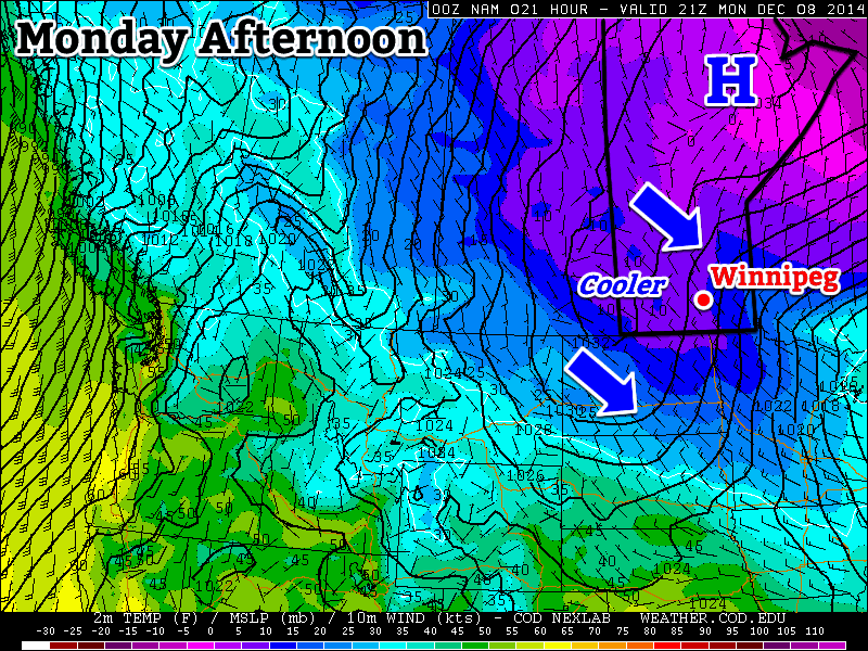
Cooler temperatures are expected in southern Manitoba on Monday
Monday
Monday
-10°C / -20°C
Mainly cloudy with chance of flurries
Today will be our last taste of arctic air for awhile! High temperatures today will be around or just below -10C with a breezy north-west wind. There may be some light flurries during the day, particularly in the morning, but they shouldn’t amount to much, if anything.
Tuesday
Tuesday
-7°C / -8°C
Mainly Sunny
Tuesday will be a bit warmer than Monday, as a strong southerly flow brings warm air into southern Manitoba. High temperatures will be in the minus single digits, which is slightly above-normal for this time of year. The only downside is that it will be very windy, with south winds of 40km/h gusting to 60km/h. Temperatures will not decrease much on Tuesday night as that strong wind keeps conditions mild.
Wednesday
Wednesday
-2°C / -2°C
Mainly Sunny
High temperatures on Wednesday will approach or exceed the freezing mark in most of southern Manitoba. South-western sections of the province should reach the freezing mark, while areas in the Red River Valley and south-eastern Manitoba remain just below freezing. Winds will remain gusty and from the south.
Long Range
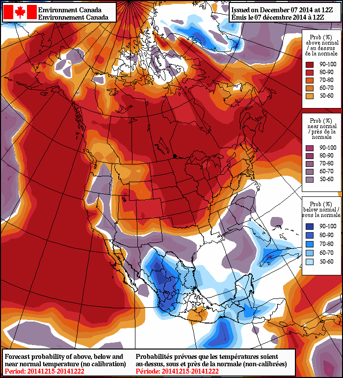
The NAEFS model suggests that above-normal weather will last through mid-December
The long range forecast is looking very good. Models are in strong agreement that our weather will remain above-normal for the foreseeable future. In fact, later this week temperatures will likely be well-above normal, with multiple days potentially being above freezing. There is no sign of any major cool-downs in the forecast – enjoy it while it lasts!
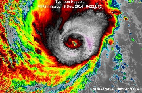
Super Typhoon Hagupit Heads towards the Philippines
The Philippines are bracing for a very strong typhoon that is expected to make landfall this weekend. Hagupit, which was formerly known as a super typhoon (with winds exceeding 240km/h) has lowered in intensity but is still considered dangerous. The slight weakening was due to an eye wall replacement that took place. As of Friday afternoon, the typhoon was located in the West Pacific and heading west towards the central islands as well as the main islands where Manila is located.
This region has seen numerous strong typhoons in the last five years including super typhoon Haiyan, which made landfall in the Philippines 13 months ago just south of where Hagupit is expected to make landfall.
Hagupit looking more ragged as it approaches the Philippines after the eye wall replacement, however the bigger eye signifies a larger wind field. (Source: NOAA)
Yesterday, Hagupit had already begun lashing the islands with its outer rain bands. Evacuations were underway this past week where around 500,000 people have already been evacuated from areas most at risk including along small coastal fishing villages and in unsafe structures. The typhoon is expected to make landfall tonight near Sorsogon City, and will likely reach a high end category three or low end category four equivalent storm, bearing sustained winds of around 200km/h. Storm surges are sure to be a problem, especially along the front right quadrant of the typhoon, where surges could exceed 10 feet. Rainfall will also be of concern since Hagupit is fairly slow moving and will be able to drop copious amounts of rain. It is expected that the hardest hit areas, around where Hagupit makes landfall, could see around 500mm of rainfall.
After Hagupit emerges back over waters, the waters of the South China Sea, it is unclear as to where it will go and what its strength will be. A few of the forecast models show it holding together and continuing straight west with at least tropical storm force winds but sea-surface temperatures are not ideal for intensification in the region.
Seasonal weather will be in place over the Red River Valley this weekend with dry conditions and comparatively mild temperatures.
Friday
-9°C / -14°C
Mixed skies and breezy
Saturday
-6°C / -8°C
Increasing cloud with late-day wind
Sunday
-3°C / -9°C
Cloudy and mild
Today will be the least pleasant day of the weekend with temperatures climbing to around -9°C with somewhat gusty northwesterly winds – around 30km/h with gusts closer to the 40-50km/h mark – ushering cooler air than we had yesterday. While we’ll see a fair amount of cloud today clearing out in the afternoon, no snow is expected. Temperatures will dip to the mid-minus teens tonight as winds taper off.
Saturday looks like a fairly pleasant day. A ridge of high pressure over the region will bring mainly sunny skies and a high near -6°C. Winds will begin picking up out of the south a little later in the day, making it feel a bit colder but limiting our overnight low to just around -8°C or so. Some light snow is possible late Saturday afternoon into the evening hours ahead of a warm front gradually lifting northwards through the night.
Sunday will be a very mild day that starts off with somewhat unpleasant southeasterly winds. By late morning or early afternoon it looks like the winds will die off and the temperature will climb to a very balmy high of around -2 or -3°C. Some snow is possible in the afternoon, but it looks like the bulk of the precipitation will remain to the north and east of the Red River Valley, with just a light dusting of snow possible. Temperatures on Sunday night continue mild with lows near -9°C.
Pattern Change Next Week Brings More Mild Weather
As we mentioned earlier this week, a major pattern shift covering much of North America will occur through the early half of next week that will move most of the continent into an above-average temperature regime for an extended duration.
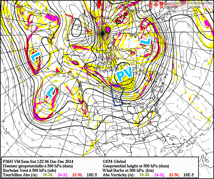
The general gist of the pattern evolution is this: over the next few days, a very strong frontal zone over the northern Pacific will shift eastwards alongside a train of upper-level disturbances reflected at the surface by a very intense low pressure system – bottoming out today at 950mb or so. This intense low will become stacked east of the Aleutians and absorb several weaker, more disorganized disturbances, becoming a very impressive, large storm over the northeastern Pacific. This intense system will build an upper-level ridge over western North America, beginning the push of warm air. The second key ingredient is the evolution of the polar vortex that has been anchored over Hudson Bay for the last few weeks.
By this weekend, shown here in the GDPS 500mb height & vorticty forecast, several very potent low pressure systems – marked by the letter L – will begin building a ridge over western North America while the polar vortex – shown by “PV” – begins a slow trek eastwards.
Fortunately, a powerful low pressure system heading up the east coast with teleconnections to the polar vortex will help “push” the vortex from its resting place and rapidly shunt it eastwards over Greenland. This is the second key ingredient because the polar vortex over Hudson Bay[1] is what anchors the eastern Prairies into a northwesterly to northerly flow for such long periods of time, reinforcing colder air and shunting warmer air to our south. With the vortex skipping town, the arctic jet stream will retreat northwards and the warm air spreading northeastwards with the upper ridge will be able to spread eastwards across the Prairies unhindered.
It’s a very interesting situation that highlights how stable the ridge-trough pattern that is so common is; in order for us to be kicked out of this pattern that has brought us a very cold November, we need very potent, significant storms on both coasts at the same time disrupting the upper-level pattern enough to get things moving again.
Within the warming pattern, we’ll see relatively warm and cool spells as disturbances ripple across the Prairies , but overall it looks quite dry in the Red River Valley as daytime highs climb into the -5 to 0°C through the second half of next week with the possibility of above-zero temperatures late into the week through the weekend. different from
Its worth noting given how much press the term “polar vortex” gets lately that this is a completely normal feature that is dominant over Hudson Bay for huge swaths of winter every single year. ↩
Wow, what a fall temperature-wise in southern Manitoba this year! From record July-like heat in late September to January-like cold in November, we saw the extremes of all seasons… Here are the average temperature and total precipitation rankings for fall 2014 in Winnipeg:
Meteorological Fall Rankings for Winnipeg
Category
Fall 2014 Average/Total
Rank
High Temp.
9.1°C
Tied 49th coldest
Mean Temp.
3.8°C
Tied 48th coldest
Low Temp.
-1.5°C
Tied 53rd coldest
Rainfall
47.3 mm
24th least
Snowfall
18.2 cm
Tied 46th least
Precipitation
59.7 mm (est.)
18th driest
The meteorological fall (Sep-Oct-Nov) averaged 3.8°C or 0.7°C below the 1981-2010 normal. The negative anomaly was due to a frigid second half of November. September and October actually averaged warmer than normal with anomalies of +0.6°C and +1.6°C respectively. November on the other hand finished 4.2°C colder than normal with an average of -8.8°C, the 22nd coldest November on record since 1872 and the coldest since 1996.
Record Heat & Humidity In Late September
The dramatic burst of July-like heat we had in late September was perhaps the top weather event of fall 2014. The bulk of the warmth occurred September 22 to 27 with 6 of those days seeing highs over 25°C, a good 10-15°C above normal for that time of year. Overnight lows remained well into the teens.
Fall colours as seen in Henteleff Park on September 13, 2014.
September 26 was the hottest day with a high of 30.2°C at Winnipeg Airport, just shy of the old record of 31.7°C in 1952. However, it was even hotter in southwestern Manitoba where the heat was literally unprecedented for so late in the season (at least since records began). In Brandon, highs of 34.0°C and 32.8°C on the 25th and 26th respectively were the hottest on record for so late in the season since 1890. The provincial hotspots during the hot spell were Swan River and Wawanesa with maximums of 35.1°C!
In Winnipeg, only 1 temperature record was broken; a record high minimum of 17.4°C on September 26. This was the warmest minimum temperature for so late in the year since 1872. Humidity was the main story with dewpoints in the teens and humidex values in the 30’s. In fact, 6 daily high dewpoint records were broken in Winnipeg during the warm spell, with a maximum dewpoint of 18.1°C on September 26. A maximum humidex value of 35.8 on the 26th was the latest occurrence of humidex over 35 on record since 1953.
October Warmth & January in November
After a brief cool down early October, things warmed up again mid-month with highs commonly in the teens. 2 days exceeded 20°C. A high of 20.6°C on October 24 was the warmest for so late in the year since 1990. Thanks to generally warm conditions in October, The Forks weather station did not report its first freeze until October 30!
Of course, winter came in viciously in mid November with a prolonged cold snap lasting until the beginning of December. A low of -29.6°C at Winnipeg Airport on November 26 was the coldest in November since 1996. We only reached a measly high of -19.3°C on the 26th and 30th, the coldest highs in November since 1985.
Dry Fall
It was also a fairly dry fall, as many of you have probably noticed. Only around 60 mm of precipitation fell in Winnipeg, making it about the 18th driest fall on record since 1872. October was driest with just 4.9 mm of precipitation (all rainfall), the 3rd driest October on record.
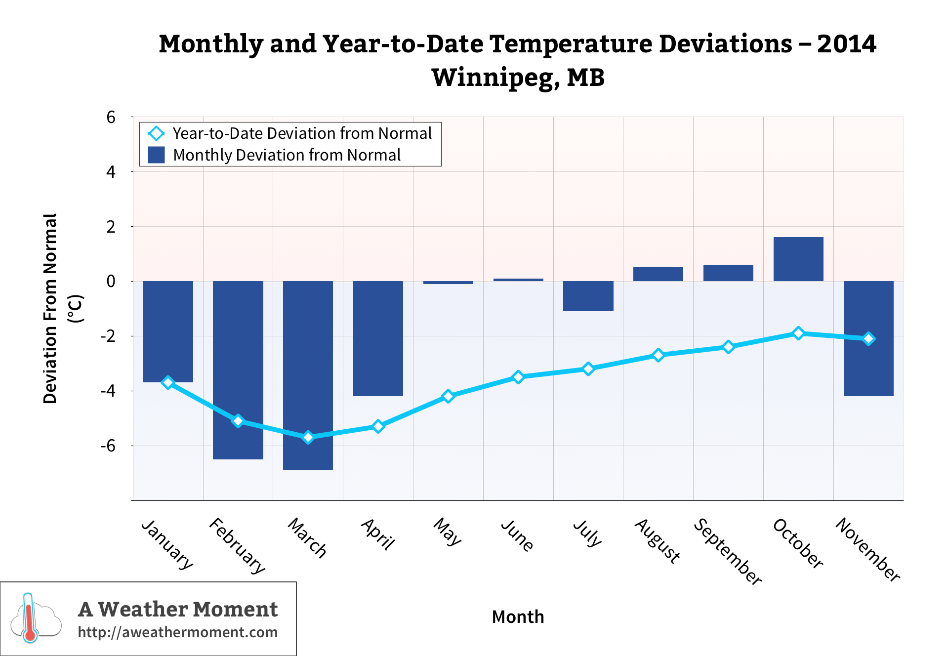
The Year So Far
2014’s standing in terms of temperature has improved (warmed) slightly since the summer summary in September, thanks to warmer conditions in September and October. This January to November period averaged 2.3°C or 2.1°C below the 1981-2010 normal for the period. It is the 22nd coldest since 1873 and coldest since 1996, which is an improvement from the 17th coldest January to August period.
Monthly & year-to-date temperature deviations through Fall 2014 in Winnipeg, MB.
391.4 mm of rain has fallen this year up to now, which is actually about 37 mm below normal for an entire year. The deficit in rainfall can be attributed to a very dry fall and below normal rainfall in the spring.