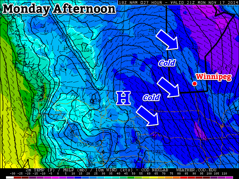
This week will remain cold as arctic air continues to spill down from the north.
A northwesterly flow will continue to bring cold weather to southern Manitoba on Monday
Monday
Monday
-8°C / -14°C
Mix of sun and cloud with chance of flurries
Today will be cold and breezy. Temperatures in the morning will be in the minus teens, rising into the minus single digits by afternoon. Skies will be a mix of sun and cloud with chance of light flurries. The wind will be from the north-west at 20-30km/h.
Tuesday
Tuesday
-7°C / -10°C
Mix of sun and cloud with chance of flurries
Tuesday will be slightly warmer than Monday, but not by much. High temperatures will once again be in the minus single digits, once again under a mix of sun and cloud. There will also be a chance of light flurries throughout the day. Winds will be breezy and from the south.
Wednesday
Wednesday
-9°C / -18°C
Mainly cloudy with flurries
Wednesday looks to be a fairly miserable day. High temperatures will be near the -10C mark, with a gusty north-west wind and flurries. This means blowing snow is likely in open areas, similar to the conditions experienced on Sunday. Winds speeds of 40km/h gusting to 60km/h are expected.
Long Range
The long range forecast calls for continued cold weather. Weather models suggest that we’ll see below-normal weather persist for at least another week. Unfortunately, it looks like winter is here to stay, like it or not.
Italy has seen its fair share of rainfall this past week, especially in the northern tier of the country including the city of Milan. Trouble started off in early November when a system originating from the Mediterranean Sea brought abnormal amounts of moisture into the region, producing heavy rainfall over a sizeable portion of Italy. This system, associated with a slow moving negatively tilted trough, dug down into southwestern Europe and triggered isolated thunderstorms and widespread rain. The system dumped copious amounts of rainfall – over 100mm fell in northern parts of Italy. With already saturated grounds from previous events in the past few weeks, this meant trouble for some villages.
Milan and surrounding areas saw the worst of the flooding. Subway systems were inundated with water, streets were flooded with over a foot of water and schools were forced to close. Two rivers in the region, the Seveso and Lambro, overflowed their banks and contributed to the flooding. The flooding is responsible for five deaths and estimated damages in excess of 100 million dollars.
Significant repairs will have to be done to this central Milan canal wall and road which collapsed due to the saturated ground below that gave way. (Source: @SimoneEneaRicco)
Northern Italy will remain soggy over the weekend, with another 10-20mm expected due to the same slow moving trough which continues to linger. Throughout November Milan usually sees about 100mm of precipitation, but just half-way through they have already surpassed it.
By the beginning of next week there’s a good chance that things will start to clear up as a weak ridge builds in.
Fairly quiet weather is on tap for Winnipeg as the Arctic air mass that has been entrenched over the region is reinforced by numerous weak systems drifting southwards in the northerly flow over the province. As a result, temperatures will remain well below normal through the weekend with some flurry activity possible.
Friday
-7°C / -15°C
Mainly sunny
Saturday
-8°C / -15°C
Mixed skies with a chance of light flurries
Sunday
-6°C / -12°C
Mainly cloudy with a few flurries
Today will be the nicest day of the next few with sunny skies as we head towards a high of around -7°C. Winds will be relatively light out of the west at 15-25km/h. Tonight will see a low near -15°C.
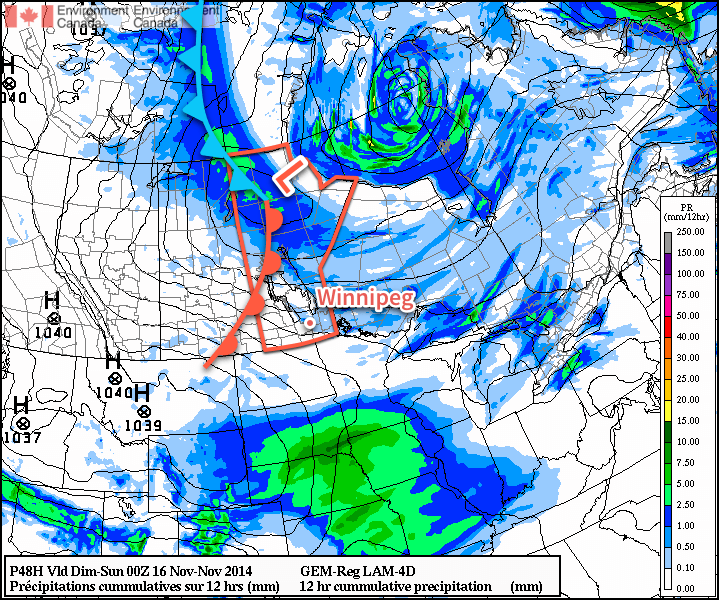
Saturday will bring mixed skies once again with a high near 8°C as winds shift back to northwesterly behind a weak trough moving through and lake-effect flurries start up again. No accumulations are expected, but you may see a few flakes in the air throughout the day on Saturday. Heading into Saturday night, a low pressure system that is making an extrodinary trip from essentially the North Pole straight to Southern Manitoba will begin working into the region. Cloud and a few flurries will spread into the region ahead of it through Saturday night.
The incredibly amplified flow over North America will bring a low pressure system from the high arctic straight south through Manitoba this weekend.
Sunday will be a mainly cloudy day with some light flurries through the Red River Valley. Northwesterly winds will result in some slightly heavier snow in the lee of the Manitoba lakes, however no significant accumulations are expected. The ability for the lakes to produce heavy snowfall is rapidly diminishing as ice cover continues to grow and expand, covering up the open water.
With all the cloud around and northwesterly winds in place, temperatures should climb a couple degrees warmer than Friday or Saturday to around -6 or -5°C. Heading into Sunday night, the clouds will likely break up a little bit, although the chance for flurries will continue. The low should drop to around -12°C, however it may end up a couple degrees warmer or cooler depending exactly on how much clearing takes place.
Quiet Pattern Continues
Looking ahead to next week, temperatures look to remain fairly steady with little expected for snowfall. Long-range outlooks show a move out from below-normal temperatures, but that’s more a result of the normal highs gradually falling. No major snowfalls are in the foreseeable future.
A reinforcing shot of Arctic air is pushing into Southern Manitoba for the remainder of the week. The cooler weather will gradually settle things and bring more sunshine than we’ve seen in the past while to the region, but before that happens another day of flurries lies ahead.
Wednesday
-5°C / -9°C
Periods of snow
Thursday
-7°C / -14°C
Mixed skies; chance of light flurries
Friday
-9°C / -15°C
Mainly sunny
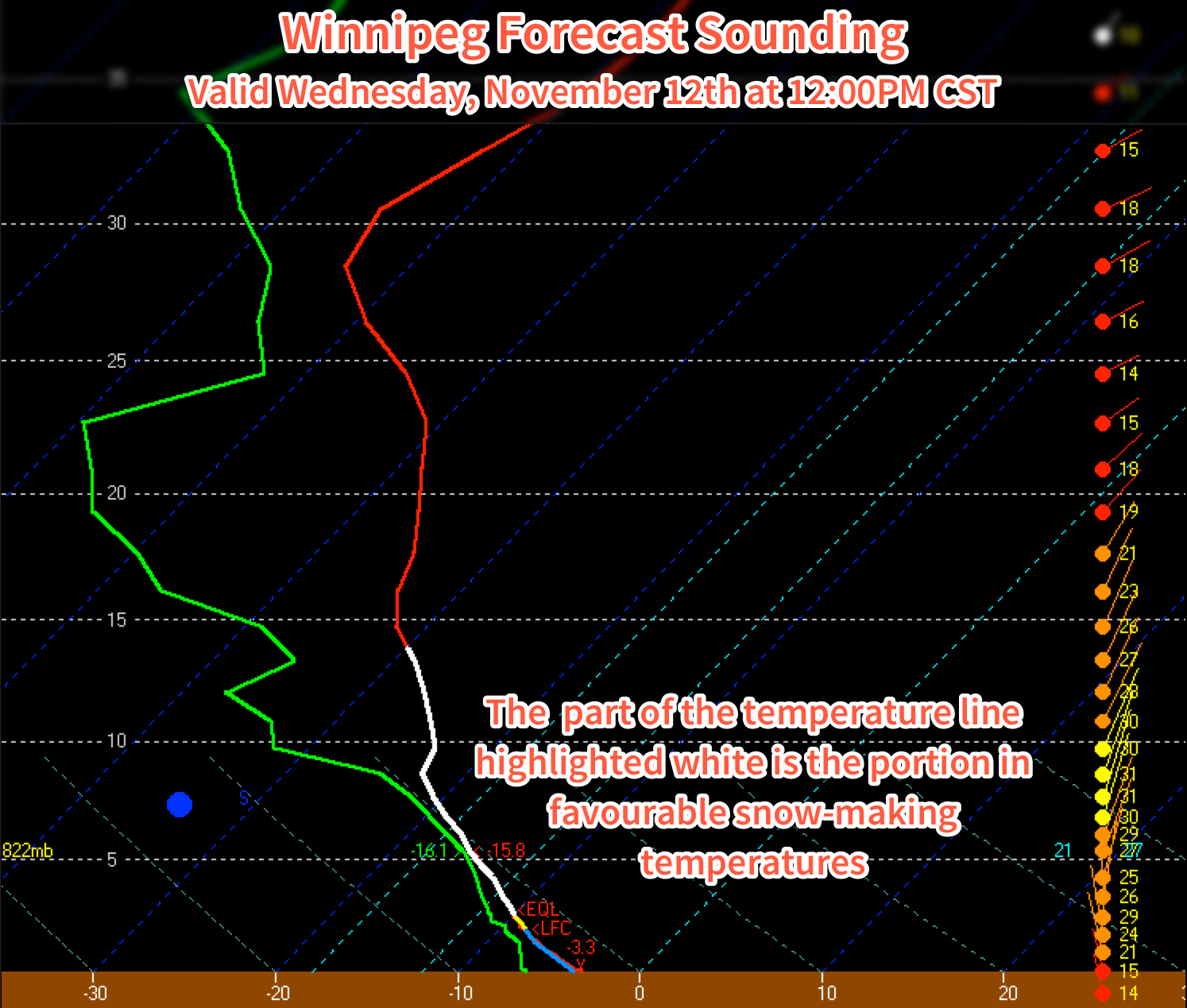
Today will bring mainly cloudy skies with flurries continuing to drift southwards from the Interlake as general instability coupled with optimal temperature profiles[1] results in periods of snow throughout the day today. Snow will begin tapering off in the late afternoon or evening as clouds begin to break up and the northerly winds around 30-40km/h shift more northwesterly and gradually weaken.
Temperatures will climb to a high around -5°C and drop to -9 or -10°C tonight.
The forecast sounding for noon today in Winnipeg shows the deep layer of favourable snow-making temperatures – shown in white – that will be in place Wednesday and Thursday.
Thursday will bring mixed skies as clouds gradually clear throughout the day. The same temperature profile will be in place as today, so any low-level clouds will likely be able to produce some light flurry activity, but nothing significant is expected. Winds will shift to westerly at around 15-25km/h for much of the day as a ridge of high pressure slumps into the Dakotas from Saskatchewan. Expect a low near -14 or -15°C under clear skies on Thursday night.
Friday will be a beautifully sunny day, but it comes with the cost of being the coldest day so far. With relatively light west to southwesterly winds flowing out of the high pressure system to our south and southwest, temperatures will climb only to around -9°C. Temperatures will drop back into the mid-minus teens on Friday night under clear skies.
Cold Weather, Flurries for the Weekend
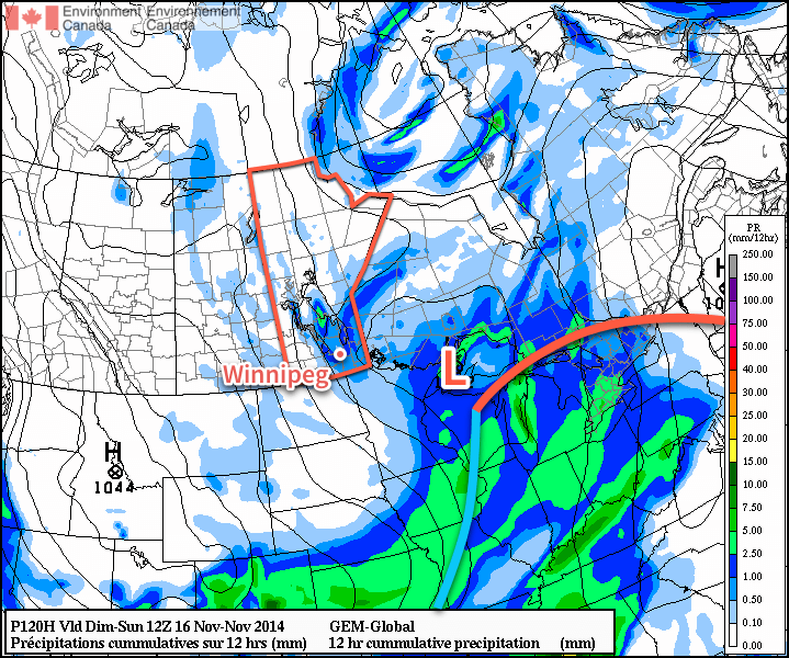
This weekend looks to bring flurries back to Southern Manitoba as another cold front pushes through on Saturday night. Snow will likely be found along the front as well as behind it through the day on Sunday as another unstable northwesterly flow develops.
The GDPS is showing another round of flurries pushing through the Red River Valley on Saturday night into Sunday morning.
Cold weather is expected to continue behind the front as another shot of Arctic air moves into the province.
Snow grows best in temperatures between around -8°C to -15°C between the surface and around 700mb. The thermal profile over Winnipeg matches those temperatures nearly exactly which will make it very easy for snow to develop. ↩