Warm & Unsettled Weather

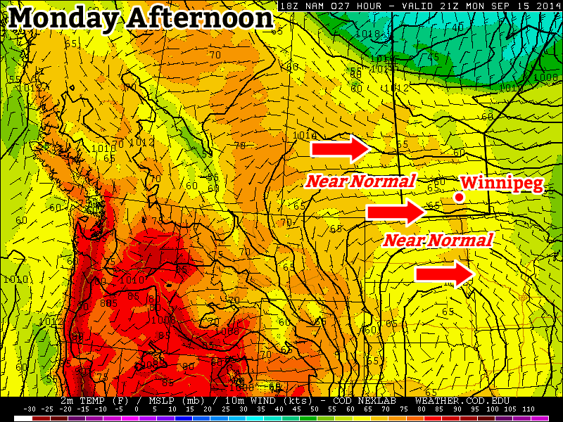
The weather over the next couple days will be two things: warmer than normal for this time of year and somewhat unsettled. While no major rain-makers are expected, a couple rounds of showers will make for some damper spells. Fortunately, daytime highs near 20°C will be above the seasonal 17°C through the weekend!

Friday
22°C / 12°C
Mixed skies; chance of showers or thunderstorms

Saturday
20°C / 10°C
Mixed skies; chance of showers or thunderstorms

Sunday
20°C / 10°C
Mainly sunny

Today will bring mixed skies to Winnipeg as a broad trough of low pressure works its way across the province. There will be a slight chance of showers this morning if any of the overnight activity manages to linger on and/or push far enough north, however nothing significant is expected. We’ll see mixed skies heading into the afternoon with a high near 22°C with winds tapering off to light.

The RDPS is forecasting a line of thunderstorms along the advancing cold front this afternoon.

Later in the afternoon the threat of showers or thunderstorms returns as a weak cold front begins slumping southwards. Severe weather doesn’t look likely, although if stronger thunderstorms manage to develop some marginally severe hail could be a possibility.[1]

Skies will clear out a bit in the evening and we’ll be left with partly cloudy skies on our way to a low of around 12°C.

Saturday will start off with just a few clouds around. We’ll warm up to around 20°C for an afternoon high with winds gradually increasing out of the west-northwest to around 20–30km/h. By mid-to-late afternoon the threat for shower or thunderstorm activity will increase as a shortwave sliding down in the northwest flow aloft begins triggering activity over Parkland Manitoba and the Interlake. That activity will slide southeastwards through the afternoon into the evening with scattered showers or thunderstorms looking fairly likely.

This map of a feature called vorticity – essentially a measure of spin – shows a potent shortwave moving across Southern Manitoba on Saturday afternoon.
This map of a feature called vorticity – essentially a measure of spin – shows a potent shortwave moving across Southern Manitoba on Saturday afternoon.

Some thunderstorms may be surprisingly strong given the relatively meagre convective indices for the day. The key will be the favourable storm-relative winds in place. Suitable turning will be in place that it’s possible — not necessarily likely, but possible — for an isolated supercell or two to develop with strong winds and large hail being the primary threats.

Skies will clear out on Saturday night as we drop to around 10°C.

Sunday will be a nice day with not a whole lot to say about it! A ridge of high pressure moving into the province will bring clear skies and relatively warm temperatures with a high near 20°C. The temperature on Sunday night will drop to around 10°C.


  1. Environment Canada considers severe hail to be 20mm or larger in diameter.  ↩

Week to End with Summer-Like Weather

Patience will be rewarded heading towards the end of the week as above-normal temperatures[1] are poised to return to Southern Manitoba thanks to a low pressure system that will push across the Central Prairies. In addition to the warmer weather, the chance for some wet weather, possibly even thunderstorms, will make a return as well.

Warmer air is forecast to spread eastwards across the Southern Prairies over the next 48 hours.
Wednesday
14°C / 3°C
Mainly cloudy & cool; clearing in the afternoon

Today will be the coolest day of the next few as we remain on the periphery of a large pool of Arctic air. Plenty of stratus cloud will persist in Winnipeg until this afternoon; afterwards we’ll see clearing skies and a high temperatures near 14°C. Another chilly night lies ahead with temperatures dropping to the 3 or 4°C mark under continued clear skies.

Thursday
20°C / 16°C
Increasing cloudiness with a breezy southerly wind

Thursday will mark our entry into warmer weather. Gusty southerly winds will develop ahead of a warm front that will gradually push eastwards through the day. Winds will peak at around 30–40km/h with the potential for gusts to around 50km/h. Much of the day looks fairly sunny which will help temperatures climb to around 20°C by late in the afternoon, but by mid-to-late afternoon clouds will noticeably begin thicken up.

The potential for thunderstorms returns Thursday night, but it’s conditional and will be mainly confined to southwestern Manitoba. Substantial mid-level instability will couple with a strong low-level jet (LLJ) in the evening to attempt to produce thunderstorms. While many severe weather parameters output by various models look fairly impressive, there are a few concerns I have with development, somewhat related to each other:

  1. Even lifting from the low-level jet, convection looks capped. If lift is strong enough to break through the cap and taps into the mid-level instability, then strong to severe storms could be possible, but…
  2. Synoptic lift looks uncertain. While the LLJ is forecast to be quite strong at 25–35kt, deeper synoptic lift looks uncertain. Some models hint at a shortwave rippling through the region on Thursday evening, which could help initiate thunderstorms if true.
The NAM is forecasting winds in excess of 40kt at 850mb over Southern Manitoba on Thursday evening.

If thunderstorms did manage to initiate over southwestern Manitoba, they would have a chance of becoming severe, with the main threats being large hail and strong winds. As the system pushes eastwards overnight, the chance for showers or thunderstorms will spread into the Red River Valley. The thunderstorm potential will diminish as the system moves eastwards.

With all the cloud, potential precipitation and breezy winds moving through overnight, temperatures will remain fairly mild, only dipping down to the mid-teens.

Friday
22°C / 9°C
Chance of morning showers; afternoon clearing

Friday will continue the pleasant weather. A slight chance of showers may persist into the morning from Thursday night, but skies should quickly being to clear out, leaving us with partly cloudy to mixed skies for the remainder of the day. Daytime highs will climb into the low 20’s without too much wind to worry about.

Temperatures will drop just under 10°C on Friday night under mainly clear skies.

The Weekend Ahead

The coming weekend looks great! Mostly sunny skies will dominate through the weekend with daytime highs continuing to sit in the low 20’s and overnight lows in the mid-to-high single digits. It will be a beautiful late-September weekend, so get out and enjoy it!


  1. Normal temperatures in Winnipeg for this time in September are around 18°C for high temperatures and 6°C for low temperatures.  ↩

Near Normal Weather to Start the Week

The beginning of this week will feature near normal weather which will be more the result of the normal high temperature dropping as opposed to the temperature rising.

Near normal weather is expected in southern Manitoba on Monday

Monday

Monday
18°C / 6°C
Mainly sunny

Today will feature temperatures in the mid to upper teens, which will actually make it one of the warmer days we’ve had lately. Skies will be mainly sunny and winds will be gusty and from the west. Overall, a cool, but pleasant day.

Tuesday

Tuesday
17°C / 6°C
Mainly cloudy

Tuesday will see the return of cloudier conditions. Temperatures will not decrease significantly from Monday’s values, but the lack of sun will make it feel a bit cooler. High temperatures will remain in the mid to upper teens with light winds.

Wednesday

Wednesday
15°C / 7°C
Mainly cloudy

Mainly cloudy conditions are expected once again on Wednesday. Temperatures will will remain in the mid teens and there will be a slight chance of showers.

Long Range

The long range forecast continues to hint at the return of warmer than normal weather by late this week or next weekend. It’s too early to say for sure, but there might be one more stretch of summer weather in our future before fall really hits.

Elsewhere in Weather News: September 13th, 2014

Severe Flooding in Northern India and Pakistan

Flooding has been the story for both last weekend and this week as heavy monsoonal rains fell across northern India and Pakistan, having its strongest impact in the Kashmir, Jammu provinces and Jhang district. In this case, the heavy monsoonal rains were caused by very moist air advecting in from the Bay of Bengal due to a low pressure system located in northern India. This moist air was then lifted as it interacted with the rugged terrain of northern India and fell as heavy rain. Satellite estimates show that over 350mm fell in the hardest hit areas in a 7 day period, resulting in rivers overflowing their banks and putting residents at risk.

Satellite image of the low pressure system over northern India; combined with orographic lift, it made for heavy rain in the region. Taken on September 5th. (Source: NASA via Wunderground)

According to news outlets, 5,000 rescues had to be executed in the flooded region as people scrambled to higher ground. When floodwaters will have receded damages will be significant; about 980 villages in the region have seen flooding problems. On Friday night it was reported that 461 people have died due to the flooding with 600 more injured. Some 60,000 residents continue to evacuate to higher ground, not only in concern of flooding waters but also infrastructure being washed out leading to significant transportation problems for food and clean water. In developing countries the residents are typically affected by not only the initial disaster, but also the aftermath of the disaster. This is the case here as water borne diseases are of great concern to officials and will be a true threat to some residents as floodwaters recede. It’s estimated that over one million people have already been affected by this disaster.

In other news several tropical disturbances have formed in the Atlantic, including a tropical storm in the mid-Atlantic. These should be watched in the next few days, however, there is fairly strong shear in the region currently which is causing problems for these storms to develop further.