Unsettled Week Ahead

Summer weather will continue to elude us as a complicated weather pattern is set to bring more unsettled weather this week. A series of moderate to strong disturbances will move through Southern Manitoba, each bringing a chance for rain. The first major disturbance looks to move through on Tuesday, with a second major disturbance coming through on Wednesday night.

The forecast surface weather pattern on Monday afternoon

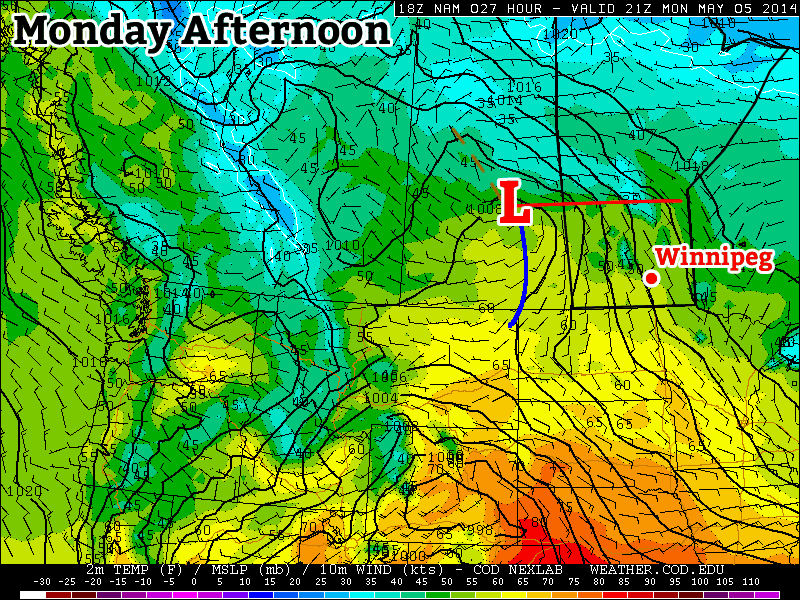
At this point it appears that each of these pieces of energy will just bring light to moderate rain to parts of southern Manitoba. However, there is always the potential for heavier amounts if convective elements (i.e. thunderstorms) become embedded within the larger area of rain. These disturbances will be coming in from the south-west along a strong jet stream.

This strong jet may also be the focus for severe thunderstorms in the US Great Plains this week, so you may wish to keep tabs on that if you’re a thunderstorm enthusiast!

Monday

Monday
12°C / 5°C
Mix of Sun and Cloud

Today will be seasonably cool, with high temperatures in the low teens. Skies will be a mixture of sun and cloud to mainly cloudy, but at least no precipitation is expected. There will be a breezy south wind during the day, but it shouldn’t be quite as windy as it was on the weekend.

Tuesday

Tuesday
15°C / 6°C
Mainly Cloudy. Showers.

Tuesday is expected to feature showers in much of southern Manitoba. There is also a slight risk of a thundershower, which may lead to isolated pockets of heavier rain. Temperatures will be in the low to mid teens with a south wind once again.

Wednesday

Wednesday
15°C / 2°C
Mainly Cloudy. Chance of Showers.

Wednesday will be, you guessed it, unsettled once again, with the threat of showers remaining in southern Manitoba. Temperatures will be in the low teens, with a light northerly wind.

Long Range

The long range forecast suggests we’ll see warmer temperatures this weekend. By warmer, we’re talking probably upper teens or maybe low twenties. It won’t be anything spectacular, but those values will feel quite warm considering the weather we’ve seen as of late.

Elsewhere in Weather News: May 3rd, 2014

Severe Weather, including Tornadoes Rip through United States

It’s been a rough week in the south-central United States for tornadoes. Monday and Tuesday warranted two consecutive high risk outlooks by the SPC for central Arkansas and Mississippi/Alabama, respectively. The system did continue on further to the Carolinas, but conditions weren’t as ripe for tornadoes. As of Friday evening, NWS had confirmed 67 tornadoes from the outbreak and from these, 11 were of EF-3 strength or higher.

Sunday was predicted to be a big day tornado-wise across Arkansas but cloudy conditions in the morning prevented much daytime heating from occurring. A mesoscale convective system (MCS) had also passed through the region the night prior which could have further disturbed the environment. With that said, the environment did manage to sustain a violent supercell in central Arkansas on Sunday which spawned the EF-4 Mayflower/Vilonia tornado. The tornado was on the ground for a length of 66.5km, at its peak produced winds of 300km/h and had a width of 1.2km. Unfortunately 15 people perished from this tornado.

Velocity data of the Mayflower/Vilonia supercell before it hit Mayflower on Sunday. Notice the intense couplet (red and blues are close), a sign of strong rotation. (Source: Radarscope)

Monday was a threatening day with numerous supercells lined up from southern Tennessee all the way down to southern Mississippi, all a posing threat to drop a tornado because of the volatile environment. The Louisville, MS tornado was one of the most significant one spawned on this day, with an EF-4 rating. It tore through the town killing 9 people and injuring several more. The tornado was on the ground for about an hour, traveling 57km. Another town that took a direct hit on that day was Tupelo, MS. The tornado, which had an EF-3 rating, passed through the northern part of the city taking the life of one person.

Supercells across the US South on Monday, notice the overshooting tops associated with the powerful updrafts. (Source: NOAA)

Tornadoes were not the only thing that this system produced on Tuesday night as the MCS stalled out over the Pensacola area of Florida producing flash flood conditions across the region. Interstates were underwater, roads got washed out and parking lots full of cars could be seen underwater. Record-breaking amounts were recorded from this event (provided by Jeff Masters blog):

  • 144mm of rain in one hour
  • 520mm of rain for the event

This weekend the pattern is much calmer across the Southern US and Plains as the atmosphere recharges for the next trough coming ashore next week.

Cool, Unsettled Start to the Weekend

Cool, showery weather will round out another week of below-normal temperatures in the Red River Valley. Unfortunately, we won’t see any significant warming through the next few days, keeping our daytime highs 3-6°C below seasonal1.

The RDPS shows convectively driven rainfall this evening through much of Southern Mantioba.

The weather over the next several days will be dominated by a series of disturbances sliding southeastwards across the province ahead of an incoming cold low aloft. The upper-level flow will keep us locked in cooler air until early next week – at the least – until any sort of significant shift in the overall weather pattern may begin to allow more seasonal warmth to begin working it’s way towards the province.

Friday

Friday
12°C / 2°C
Early morning showers ending then a slight chance of showers through the day. More showers in the evening.

We’ll see a few lingering showers from the overnight period this morning as a low pressure system exits the Red River Valley into Minnesota. The organized preciptiation should taper off fairly early this morning, leaving us with some mixed skies and temperatures on their way to a high of around 11°C.

A weak trough line will extend along a NW/SE line through the Red River Valley, and it’s possible that we may see a few disorganized showers through the day as a result of the daytime heating. If anything develops, it will likely be short-lived and relatively unremarkable thanks to fairly limited low-level instability.

Another low pressure system will slide along the trough line into the Red River Valley this evening, bringing with it another batch of showers. The instability associated with this second low looks rather decent, and if it arrives early in the evening while we’re still near our daytime high, the showers that develop – in particular further to the southwest near the Turtle Mountains and eastwards towards the Pembina Valley – could intensify enough to become a few thunderstorms. There’s no real risk of severe weather, but at this point I think that any sign of summer, even a thundershower or thunderstorm, would be a welcome sight to most people.

The Weekend

Saturday
8°C / -1°C
A few early morning showers, then mainly sunny.

Sunday
10°C / 0°C
Mainly sunny.

Saturday will start out similar to Friday morning, plus or minus a couple hours, as a few showers right underneath the upper-level disturbance associated with Friday night’s low pressure system exit out of the Red River Valley. We’re in for the coolest day of the weekend with a high of only around 8°C as a northerly flow continues to push unseasonal Arctic air southwards over the region. There will be some afternoon cloud that pops up and it should stay at that; the overall level of instability will be quite a bit less than Friday. Saturday night will be another late-season sub-zero night with temperatures dropping to -1 or -2°C through the Red River Valley under clear skies.

Sunday will feature light winds and mainly sunny skies with temperatures climbing to around 11°C. Some cloud cover looks to push in through the evening hours and we’ll see an overnight low near 0°C.

Next Week

The start of next week looks cool with mixed skies for much of the first half of the week. Early indications are that a series of low pressure systems tracking through the Northern Plains will bring showers to Southern Saskatchewan and perhaps southwestern Manitoba, however a blocking ridge will shunt precipitation southwards into the States, leaving us with cool, dry weather and variable cloud. The NAEFS2 continues to predict below-normal temperatures in the 8-14 day range.

  1. Seasonal daytime highs over the next few days sit around 16-17°C.
  2. North American Ensemble Forecast System

Cool Spring Drags On

The NAFES continues to forecast below-normal temperatures.

Those looking for warmer, summer-like weather are going to have to look elsewhere as the unsettled, below-normal temperatures we’ve become so familliar are set to continue through the next week or two.

Wendesday
10°C / 1°C
Mixed skies with a chance of showers.

Thursday
10°C / 0°C
Mainly sunny.

Friday
10°C / 0°C
Increasing cloud; chance of showers.

We’ll see mixed skies today as cloud cover pushes westwards from Northern Ontario as the Colorado Low that’s been the genesis for the massive tornado outbreak in the Deep South over the past few days. Closer to home the weather won’t be dangerous in the least; we’ll see just a slight chance of some shower activity pushing into the Red River Valley from the east. We’ll see a high near 9 or 10°C with winds out of the north at 30 gusting 50km/h. Things will clear out tonight as we drop to around 0°C.

Thursday will be quite similar to Tuesday: mainly sunny, a high near 10°C and a bit of a wind out of the east. Otherwise quite unremarkable. We’ll drop to near 0°C on Thursday night.

Friday will bring the next batch of slightly unsettled weather as a disturbance slumps southeastwards out of the Northern Prairies. Our temperature will once again climb to around 10°C, but we’ll see more cloud than sun and what, at this point, looks to be a decent chance of some more shower activity. Expect a low near – surprise! – 0°C once again.

Cool Weekend

Things become sunnier for the weekend, but temperatures don’t look to improve for the weekend. Any potentially lingering shower activity will move off on Saturday morning, leaving us with some sunshine and a high near 9°C. Sunday will be mainly sunny with a high near 10 or 11°C.

The below-normal temperatures[1] will continue through the next week. Another chance for rainfall looks to move into the region early next week as a low pressure system works it’s way thorugh the Northern Plains of the United States.


  1. Normal daytime highs for this time of year are around 16°C.  ↩