Melt weather will continue this week, giving our snowpack a well deserved beating.
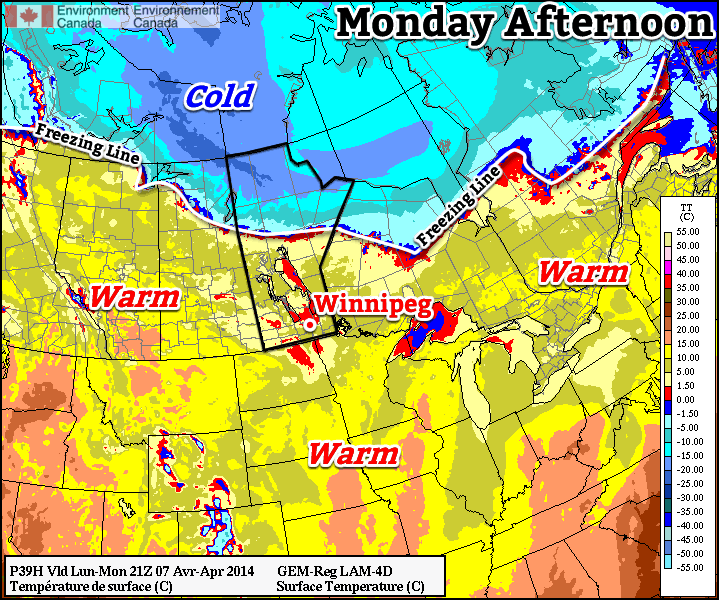
Warm weather will dominate southern Canada on Monday
Monday
Monday
4°C / -5°C
Mainly Cloudy
Today will feature temperatures similar to what we saw on the weekend. Highs will be in the mid single digits, although it will be a mainly cloudy day. The wind will be relatively light and from the west or north-west.
Tuesday
Tuesday
6°C / -1°C
Mainly Cloudy
Tuesday will be very similar to Monday is many respects. Skies will once again be mainly cloudy, but with an increasing southerly wind. High temperatures will once again be in the mid single digits.
Wednesday
Wednesday
10°C / -2°C
Mix of Sun and Cloud
Wednesday looks to be one of the warmest days of the week. An approaching low pressure system will push a warm air mass into southern Manitoba, potentially sending temperatures soaring into the positive teens. Snow-free areas just to our south could be even warmer, with Grand Forks and Fargo potentially having a shot at reaching 20C for the first time this year.
Long Range
We’ll see a slight cool down after Wednesday, with temperatures on Thursday dropping back down into the single digits. Models suggest that we’ll generally see below-normal conditions through the middle of the month, but thankfully that just means temperatures will be lower than +10C, which won’t really feel that cold in general.
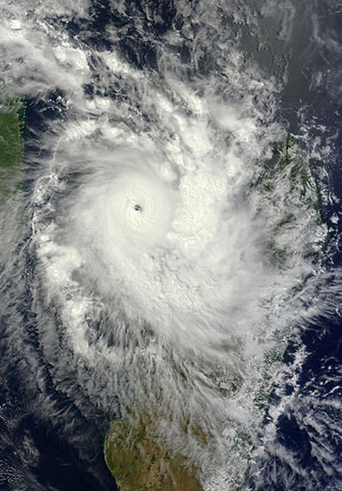
Madagascar’s week did not start off on a high note, as a strong cyclone dubbed “Cyclone Hellen” took aim at the country. Hellen took a turn towards Madagascar on Sunday and quickly deepened due to ideal cyclone conditions – as much as 60mb drop in 24 hours – over the warm waters surrounding Madagascar. Considered a very powerful storm for the country, this category four cyclone brought winds of 230km/h, while located in the northern part of the Mozambique Channel to the northwest of Madagascar.
Image of Hellen on Sunday, after it underwent rapid intensification, still over the northern Mozambique Channel. A well-defined eye can be seen. (Source: NASA: MODIS/LANCE)
Fortunately, the saving grace that helped avoid widespread damage to the country was that the eye of the storm was very compact and it collapsed easily after moving off of the warm ocean waters. The surface pressure of the cyclone went back up 65mb in the following 24 hours. Because of this, sustained winds significantly weakened to around 80km/h after making landfall therefore only a few coastal areas received damage to structures. Mahajanga, a large city with a population of over 100,000 and located close to where the cyclone made landfall, received just over 150mm from the storm. Although landslides were of concern over Madagascar’s rugged inland terrain, residents took necessary precautions and no injuries were reported. Hellen’s remnants lingered over Madagascar before getting pushed over to the neighbouring country, Mozambique, then dying off.
Another unrelated tropical storm is currently spinning up in the western Pacific Ocean and is headed toward the Philippines. This storm however, is not benefiting from ideal conditions for typhoon intensification. It is not expected to strengthen to more than a category one and will likely be more of a rain-maker than a powerful storm. The small Pacific island of Palau should still be on the lookout though, as the storm is on track to pass directly over the island. Regardless, an eye (no pun intended) will need to be kept on this storm.
Temperatures will finally push towards seasonal values this weekend as a warmer air mass pushes into Southern Manitoba from the Western Prairies. Daytime highs are set to climb into the mid-single digits which will bring the warmest temperatures since March 14th of this year when we managed to struggle our way to +4.0°C. Tagging alongside the milder temperatures will be unsettled conditions with multiple chances for precipitation through the next few days.
Friday
Friday
0°C / -5°C
Mainly sunny.
Today will be quite a pleasant day with mainly sunny skies and a high near 0°C. A ridge of high pressure will keep the winds light through the day as well. There may be a few cloudy periods this morning as we clean out any remnant cloud from yesterday’s system, but otherwise there should be plenty of sunshine.
Later today will see the approach of a warm front tied to a low pressure system tracking through the northern Prairies. Winds will increase out of the south to around 30km/h tonight as the warm front approaches. Thanks to the wind and some cloud pushing in later in the night, we’ll drop to only around -5°C.
Saturday
Tomorrow has the potential to be a bit of a messy start to the week. The warm front will be pushing it’s way through early in the day, bringing with it the potential for some snow or freezing rain.
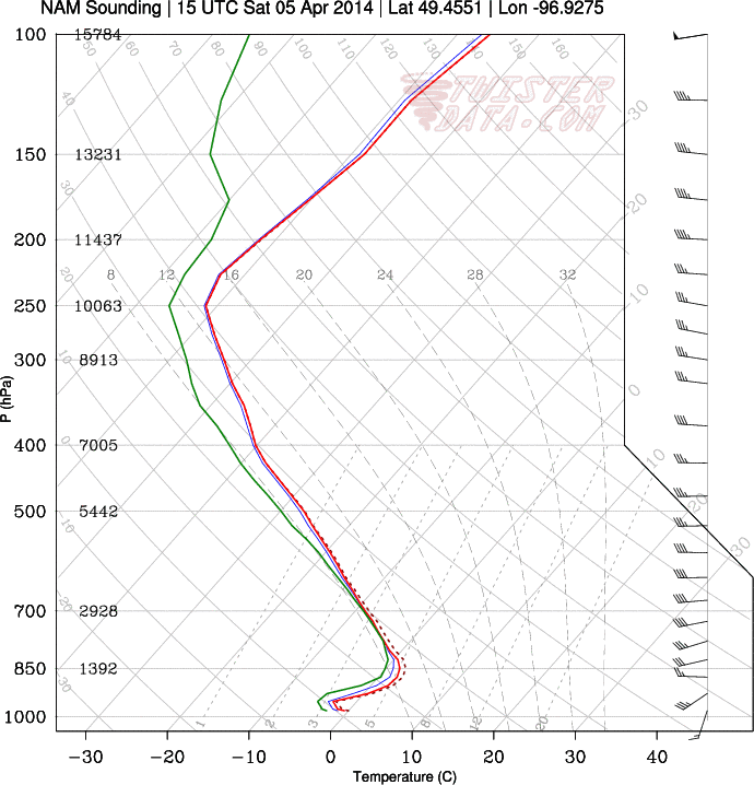
Winnipeg forecast sounding for Saturday morning from the NAM.
This forecast sounding shows the development of a small layer of above-freezing air (AFL) above a below-freezing layer of air at the surface. The AFL doesn’t look very deep, so freezing rain is far from a sure thing as the balance between melting snow and reinforcement of warm air will be a delicate one dependant on how intense the precipitation is.
Saturday
7°C / -5°C
Cloudy with chance of flurries or freezing rain in the morning, then clearing.
Depending on whether or not the precipitation manages to build far enough south to reach the Red River Valley is the primary unknown; if it does reach us then there’s a chance it will fall as freezing rain instead of snow. Whatever it decides to fall out of the sky as, though, it will be fairly short-lived and confined to the morning.
After the warm front pushes through in the morning, skies will begin to clear up and the temperature will begin climbing towards a high of 6 or 7°C. Saturday will be the warmest day in Winnipeg since the temperature hit 10.3°C on November 13th last year. Winds look to be light through the day.
Temperatures will drop to around -5°C once again on Saturday night with light winds.
Sunday
Sunday
3°C / -9°C
Mainly sunny.
Sunday will be a slightly cooler albeit still pleasant day. Winds will be relatively light out of the south as we head to a high temperature of 3°C. An incoming low pressure system will spread cloud into the Red River Valley late in the day and bring a chance of some flurries through the evening and overnight periods.
All in all it will be a fairly pleasant weekend without too much wind and some mild temperatures. Aside from a few brief chances for precipitation, it might actually feel quite spring-like out there! Enjoy!
After an exciting start to the week thanks to a Colorado Low that brought anywhere from 20-50cm of snow through portions of Southern Manitoba, North Dakota, Minnesota and Ontario, conditions are poised to return to near normal by the end of the week.
A low pressure system will bring seasonal temperatures for the weekend in Southern Manitoba.
A west-to-southwesterly flow aloft will slowly bring warmer air into our region and allow our temperatures to finally snap out of the 10-15°C below normal regime Southern Manitoba has been stuck in for the past week and push towards seasonal values for this time of year. The considerable snow pack still remaining will limit our ability to warm above 0°C without any strong push of warm air as any extra energy the sun is giving at this time of year will be going into melting snow, not warming air.
Wednesday
-1°C / -13°C
Sunny.
Thursday
-1°C / -10°C
Becoming mainly cloudy. Chance of flurries.
Friday
+1°C / -8°C
Clearing.
A weak ridge of high pressure will keep skies clear and winds light today as temperatures climb to around -1°C. Temperatures will drop to around -13°C tonight with increasing cloudiness as a weak inverted trough extending northwards from a Colorado Low tracking through the Central Plains pushes into our region.
Thursday will be mostly cloudy – perhaps a few sunny breaks – with a slight chance for some flurries. There will be more organized light snow in southwestern Manitoba, perhaps a cm or two, but the inverted trough will slowly weaken and fizzle out as it pushes towards the Red River Valley. By the time it reaches Winnipeg, it seems likely that all that will remain is very disorganized and light flurry activity. Temperatures will climb to around -1°C again and drop to a low near -10°C overnight under mostly cloudy skies.
On Friday, the day will likely start cloudy but clear out through the morning leaving a mainly sunny afternoon. Temperatures will manage to squeak above the freezing mark to +1°C or so, making for quite a pleasant afternoon. Expect an overnight low around -8°C on Friday night under mainly clear skies.
Mild Weekend on the Way
Things look set to bring the warmest air of the year into the region for the weekend. A fairly strong low pressure system is forecast to track through the northern Prairies, dragging mild Pacific air eastwards as it goes. A warm front looks to push through on Saturday afternoon, bringing with it a slight chance for some flurry or shower activity. Temperatures will climb into the low single digits with breezy southerly winds in the 30-40km/h range.
Sunday will be perhaps the nicest day we’ve seen in a long, long time. The Red River Valley will be smack dab in the middle of the warmest air and temperatures will climb to a more seasonal 5 or 6°C before a cold front pushes through in the evening.
Unfortunately, it appears we’ll see a return to below-normal temperatures after that. Exactly how cold is uncertain, however we’ll likely see plenty of “below normal” due to the extensive snow pack that still has a long way to go until it’s melted. On the bright side, it won’t be long until “below normal” will still be above freezing…