Warming Up, Then Cooling Down

After a snowy, but mild weekend, we’ll see some warmer weather return – but it will be short-lived.

A southerly flow will bring slightly warmer air to Southern Manitoba on Monday

Monday

Monday

Mix of Sun and Cloud. Chance of flurries/showers
-1°C / -4°C

A southerly flow will develop through Southern Manitoba on Monday, bringing some slightly warmer weather along with it. There may be a few flurries on Monday, but no significant precipitation is expected. The wind will be relatively light and from the south.

Tuesday

Tuesday

Mainly cloudy.
3°C / 0°C

Tuesday will be warmer than Monday, as a developing low pressure system ramps up that southerly flow from Monday. Hopefully Tuesday’s warm conditions will allow some of the weekend’s snowfall to melt. The wind won’t be much stronger than on Monday, but the direction will shift to be more from the south-east.

Wednesday

Wednesday

Decreasing Cloudiness. Temperature Falling.
-6°C / -14°C

The low pressure system that brought the warmer weather to Southern Manitoba on Tuesday will move into the region on Wednesday. It appears that this system will generate an area of moderate snowfall to the north of its track, but no precipitation to the south of its track. At this point it appears the system will track in a fashion that results in no snowfall for most of Southern Manitoba, save for perhaps some parts of Western Manitoba. Regardless of whether or not this system brings us snowfall, it will bring us colder weather. A strong cold front associated with this low will bring down another arctic airmass, dropping temperatures well below zero for Wednesday and Thursday.

Long Range

The long range forecast currently looks on the cold side. Following the passage of that cold front on Wednesday models don’t hint at any immediate return to warmer conditions. Bear in mind that we are quickly moving into late November, so warm weather will being harder and harder to come by. On the bright side there is still no significant snow in the forecast, so we’re not in a true winter pattern quite yet!

Elsewhere in Weather News: November 16th, 2013

Typhoon Haiyan Final Update, Moderate Risk for Midwest US

It’s been over a week since super typhoon Haiyan made landfall in the Philippines and a second landfall over Vietnam. The impacts in the Philippines and Vietnam are just now starting to surface and the reports coming out of the countries are not good.

Vietnam had had quite a bit of time to prepare for the storm and 70,000 people were evacuated from low lying areas. These preventive measures surely saved lives in the flood-prone and landslide-prone areas of Vietnam, but unfortunately five people still lost their lives in the floods. Storm surge was not as big an issue as it was for the Philippines as Haiyan had significantly weakened by the time it made landfall in Vietnam.

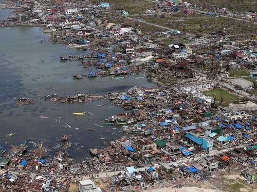
For the Philippines the death toll continues to climb (3,600 people) as the cleanup continues. One neighbourhood of Tacloban City of about 10,000 people has been literally washed off the map according to the city’s mayor, with no houses left. An early estimate for the damage is 12-15 billion dollars.


Aerial picture of Guiuan, one of the hardest hit areas, to the east of Tacloban. (Source: National Post)

Unfortunately, this past week another tropical disturbance made its way to Vietnam and brought anywhere from 250mm to 500mm in the central part this past week. To the already saturated grounds, this was enough to cause some more flash flooding. As of Friday night’s reports 3,500 houses had been lost and power was out for various cities in central Vietnam. In total, 17 people had lost their lives from this event.

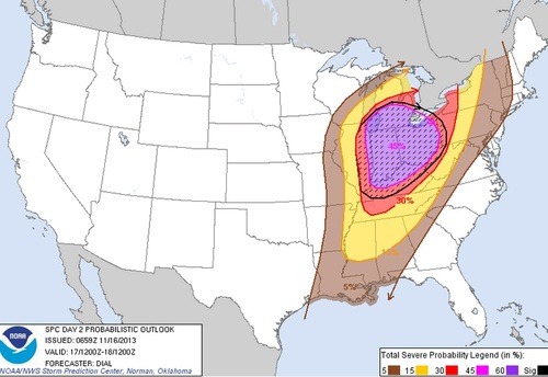
In other weather news this week, a negatively tilted trough will be making its way across the US Midwest and has the chance to produce some severe weather on Sunday. SPC has outlined a 45% hatched area, moderate risk stretching up to Southern Ontario. Though CAPE is limited, shear is quite impressive, thus, severe winds will be the main threat with this event. If the sun does get a chance to heat up, brief spin-ups could become a threat with the low cloud bases. It is not all that common to see severe events of this magnitude stretching up to Southern Ontario in the middle of November.


45% hatched area for the US Midwest, the main threat will be wind damage. (Source: SPC)

More Mild Weather Ahead

Southern Manitoba will see seasonably warm temperatures today as mild air streams into the region aloft.

The Red River Valley will bask once again in above-normal temperatures as another shot of warm air pushes up from the south. We’ll have mixed skies and a somewhat stiff southerly wind accompanying the warmer temperatures, but it should still be fairly pleasant for mid-November nonetheless.

Today

Friday

7°C / -1°C
A mixed sky; mild and windy.

We’ll see mixed skies develop today with some patchy fog throughout the Red River Valley this morning which means, especially when combined with some ice on the roads, drivers – especially highway driving – should take care if travelling through the earlier hours of the morning. Winds will increase to 30–50km/h out of the south by midday as the warmer air pushes in. Temperatures will climb to around 6–7°C, perhaps a degree higher if the clouds break up sooner than later, for a daytime high some 10°C above normal! More cloud will roll in tonight as another disturbance begins pushing into Central Manitoba. A band of snow will set up through the Parkland region eastwards through the northern Interlake, but here in the Red River Valley we’ll just see increasing cloud through the night as we drop to a low of only around –1°C.

The Weekend

Saturday

4°C / -3°C
Cloudy & mild.

Saturday will bring more mild weather despite having mostly cloudy skies through the day. Precipitation is unlikely for us; at this point it appears that everything or to our east. If the entire setup ends up a little further west, we might see a very slight risk of a shower, but as I said, I think that’s quite unlikely. Other than that, Saturday will be quite an uneventful day here in Winnipeg. Winds will be light as we sit in the middle of a large surface trough stationed over the area.

Sunday

↘ -5°C / -12°C
A mix of sun and cloud.

Sunday will see cooler air to our NW finally pushing back into the region. Our temperature will drop to near –5°C through the morning hours and then remain there for the rest of the day. Sunday night will see the true return of the Arctic air as temperatures dip all the way into the minus teens. Winds will be out of the northwest at 20–30km/h. No precipitation is expected. Or is it?

12hr. Precipitation accumulations from the NAM heading into Sunday morning.

While most models are pushing the system that will be in the area the next few days off to our east as it intensifies on Sunday, the NAM has hinted at it not pushing off quite so quickly. In one of its solution, the system intensifies further west, developing an area of heavy snow right on top of the Red River Valley. If this solution panned out, that would mean easily 10–20cm of snow by the end of Sunday. At this point, though, I don’t quite have enough faith in the NAM to say it’s likely. There’s overwhelming consensus throughout every other Canadian and European model that things will move off to the east, to the point where this solution of the NAM can’t be looked at as anything more than an anomaly.

Sometimes these interesting little anomalies end up being the right answer though, so we’ll definitely be keeping an eye on things and providing updates if things trend towards a snowier solution on Sunday.

One Warm Day Before Flurries

Southern Manitoba will bask in temperatures well above-normal today before a cold front slumping southwards across the Prairies pushes through on Thursday, bringing seasonal weather back to the region.

Wednesday

9°C / -2°C
Warm and windy under a mixed sky.
Thursday

0°C / -6°C
Cloudy with flurries.
Friday

5°C / -4°C
Warming up with under a mixed sky.

Today

We’ll see a beautiful – albeit windy – day today as warm air washes over the Red River Valley. We’ll see winds out of the west at 30–50km/h as our temperature soars almost a whole 10°C above normal for this time of year to a daytime high of 8 or 9°C. We’ll see a mixed sky, but no precipitation is expected and this will almost certainly be the warmest temperatures in the area for the next long while.

Thursday

Our warm weather will be relatively short-lived, however, as a cold front dipping southwards across the Prairies pushes through on Thursday morning. With it’s passage, we’ll see much cooler daytime highs of only around 0°C under cloudy skies. The wind will be out of the northwest at 20–40km/h. We’ll also see flurries through the day, but no accumulations are expected. The flurries will taper off overnight as we drop to around –6°C.

Friday

Friday will see the return of warmer air as a rapidly deepening low pressure system north of 60 draws warmer air northwards over the Eastern Prairies. We’ll see our temperature here in Winnipeg climb to around 5°C with south/southwesterly winds developing through the day to 20–40km/h.

All in all not a bad few days to have in mid-November. We may see our first significant accumulating snow this weekend if a complex of low pressure systems align properly, but at this point there’s far too much uncertainty to say that much of a risk yet. We’ll see how things develop through the week and report back on Friday!