Elsewhere in Weather News: October 12th, 2013

India Braces for Super Cyclone Phailin

An extremely powerful cyclone churning in the Bay of Bengal is targeting India’s east coast and is expected to make landfall this morning. This is one of the strongest cyclones India has seen in recent history and the strongest since 1999. Phailin has maintained category five status since Friday afternoon and is expected to only slightly weaken to a high end category four (as its eyewall moves over land) before making landfall. Conditions were primed for quick intensification on Thursday; SSTs approaching the 30°C mark and shear quite low. Phailin went from a tropical cyclone to category four on Thursday thanks to these ideal conditions for intensification. Already, India has evacuated tens of thousands of residents from low lying coastal areas but Phailin still has the potential to wreak much havoc on India. Already one death has been reported associated with a tree falling onto a house as of Friday night.

Phailin

Incredible image of Phailin just before it makes landfall; a well defined eyewall and very cold cloud tops are present showing that the storm is well-organized. (Source: CIMSS)

Storm surge will be a real problem with this cyclone – a forecasted 11 foot storm surge is expected to arrive as Phailin makes landfall near Brahmapur. The good news is that the coastline goes up in elevation fairly quickly as you move inland, therefore residents that should be most concerned with storm surge should be the ones that live near shorelines. With category five cyclones like this one winds as well as flooding problems are almost a given. In this case, winds will be sustained over 240km/h, gusting over 300km/h, and anywhere from 200mm to 350mm can be expected to fall around where Phailin makes landfall. The cyclone is expected to move inland and die off fairly quickly as it moves over land as opposed to being over warm ocean waters.

SST and shear

Sea surface temperatures, overlayed with shear. Note the low shear values (5-10 knots) and SSTs between 29°C and 30°C; sufficient to sustain category five storms. (Source: CIMSS)

Another storm; typhoon Nari is currently threatening Vietnam to make landfall at the beginning of next week. It is still recovering from its passage over the rugged islands of the Philippines but is expected to strengthen to a category three typhoon over the South China Sea before landfall. Models are suggesting yet another typhoon to spin up behind Nari but this one is expected to take a turn towards Japan. So, overall a very active weekend and upcoming week cyclone and typhoon-wise!

Late-Season Thunderstorm Risk Kicks off Dreary Weekend

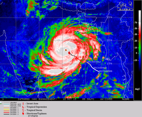
A powerful low-pressure system pushing northwards out of the Dakotas that will bring copious amounts of rainfall to SE Saskatchewan and Western Manitoba will also bring a risk for thunderstorms, perhaps even an isolated severe thunderstorm, this evening in advance of an occluding cold front. This will mark the start of a somewhat dreary weekend for the Red River Valley that will be marked most notably by a wet & windy Saturday and a very cool, albeit sunny, Sunday.

Thunderstorms Possible Today

Friday

19°C / 12°C
Mainly cloudy. Chance of showers with the risk of a thunderstorm late in the day.

We’ll see a mainly cloudy day today with relatively nice temperatures as we sit in the warm sector of the low pressure system pushing into the province. Despite the cloudy weather, we should see temperatures climb to around 19–20°C for a high with south-easterly winds to around 30km/h.

We may see a shower early this morning as the warm front pushes through and brings us into the warmer air, although a majority of the activity will be off to our west. If anything manages to push into Winnipeg, it will be relatively short-lived. After that we’ll see no chance of precipitation until later in the afternoon or the evening as a cold front begins pushing into the Red River Valley from the south.[1]

Event outlook for Friday, October 11th.

Event outlook for Friday, October 11, 2013.

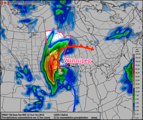
While we sit under cloudy skies, this would be a good time to note that the weather to our west will be decidedly different. Rain will push in early this morning and spread NNE through the day, hitting areas west of the Red River Valley and Lake Manitoba the hardest. In total, anywhere from 35–75mm of rain is expected, with the lesser amounts closer to the Red River Valley and the higher amounts running along the Saskatchewan border then towards Lake Winnipegosis with enhanced precipitation near the Riding Mountains as upslope enhancement in the north-easterly winds amplifies the amount of rain. Environment Canada has rainfall warnings out for many regions in Western Manitoba, and you can check here to see if your region is covered by one and find additional details.

As the cold front approaches the Red River Valley this evening we’ll see considerable destabilization of the mid-levels coupled with an extremely strong 60–70kt 500mb jet beginning to poke it’s nose north of the border. The Red River Valley will lie in a fairly diffluent area aloft with strong convergence along the cold front as it pushes northwards. Limited surface moisture will constrain SBCAPE values to only a mere 400–500J/kg, but the extremely strong dynamics, in particular the strong directional and speed shear, may help promote the growth of strong-to-severe thunderstorms along/just ahead of the cold front.

This all is highly dependant on either enough destabilization occurring or enough convergence occurring along the cold front. At this point, I think that the southern Red River Valley will see the strongest storms with a lesser risk of strong storms further north here in Winnipeg. By the time the front reaches us, it seems like it will be a band showers and/or thunderstorms with less organization than when things initiate in the Dakotas. If any of the storms do become severe, the main threats will be large hail and strong winds. There will be a very small risk of a few weak tornadoes with these storms, but I believe that will be most likely in North Dakota with the odds diminishing fairly rapidly as you push northwards through the Red River Valley.

The showers/thunderstorms will push through overnight as we drop to a low of around 11 or 12°C.

Wet & Windy Saturday

Saturday

↘ 6°C / 2°C
Cloudy with showers. Windy. Temperature dropping through the day.

Saturday in Winnipeg will be marked by wet and windy weather as we move onto the back-side of the Colorado low and see some wrap-around rain and gusty northwesterly winds move in.

The rain will likely be somewhat showery in nature – in that we won’t see solid rain all day long – and there’s some uncertainty on how much we’ll see exactly, but around 5mm seems like a relatively safe bet at this point. If the system is a little faster than forecast we could end up with almost nothing as the rain would fall further north, and if it’s slower than forecast we could see closer to 10mm as we end up under the wrap-around rain for even longer.

The wind will be the main weather story though. Here in Winnipeg we’ll see winds 30–40km/h out of the northwest with gusts up to 60km/h, but it will be a significantly different story for those on the lakes. Winds over the lakes will increase to nearly 50–60km/h on Saturday with gusts as high as 90km/h, which will produce fairly sizeable waves. If you have a home or cottage on the southern or eastern shores of the lakes, you’ll want to make sure you make any preparations you might have to and prepare for some strong wave action and howling winds for Saturday and Saturday night.

With those strong winds will come falling temperatures; here in Winnipeg we’ll likely see temperatures fall to around 5 or 6°C by the end of the day as colder air pushes in on the back-side of the low. Skies will clear and winds will lighten overnight as we drop to around 2°C for our overnight low.

Sunny but Cool Sunday

Sunday

9°C / -2°C
Sunny. Cool.

Sunday will see the return of the sun, but the price we’ll pay is significantly cooler weather than we’ve been having over the past week. Daytime highs on Sunday will top out at only 9 or 10°C and it will be a slow climb to get there. Temperatures will likely drop well below 0°C on Sunday night with a hard frost likely as temperatures dip to around –2°C.

This will also mark the transition into a cooler pattern. Daytime highs will remain around 10°C through much of the week.


  1. It sounds odd, but this system is essentially sideways with the warm front and cold front both moving from south to north.  ↩

Warm Week Ahead with an Unsettled End

Unseasonably warm weather will settle in over Southern Manitoba over the next few days with daytime highs soaring 7–8°C above the normal 12°C for this time of year. Week’s end will bring unsettled weather into the province as a low pressure system lifts northwards out of the Central Plains of the United States.

Wednesday

19°C / 7°C
Mainly sunny with a few cloudy periods in the afternoon.
Thursday

19°C / 12°C
Increasing cloud through the day. Chance of showers in the evening.
Friday

18°C / 8°C
Cloudy. A few showers likely.

Today & Tomorrow

We’ll see a very pleasant day today with a high around 20°C and bright sunny skies light winds out of the southwest. We may see a little afternoon cloud, but nothing too significant. Tonight will be a fairly seasonable night with mostly clear skies and a low near 7°C.

Tomorrow will start off mostly sunny, but we’ll see some scattered cloud through the day and by late in the day we’ll start to see more organized cloud cover starting to push into the Red River Valley from North Dakota. There will be a slight chance of a shower through the evening hours as a warm front lifts north through the Red River Valley & Interlake regions but no significant accumulations are expected in our region.

An Unsettled Friday

Friday will most likely end up a somewhat unsettled day as a low pressure system tracks through the Red River Valley. This disturbance will bring a fair amount of rain to Western Manitoba; at this point it looks like close to 40–50mm will fall near the Saskatchewan border. Here in the Red River Valley rainfall will be lighter and more disorganized in nature. We’ll see a decent chance of some light scattered showers through the Red River Valley through the day under cloudy skies. The temperature should climb to around 18°C as we sit just on the warm side of the main frontal boundary of this system.

12hr. QPF valid Fri. 12Z - Sat 00Z w/Frontal Analysis

Forecast rainfall through the daytime on Friday from the GDPS. Rainfall accumulation 12Z – 00Z; low position & fronts valid for Saturday 00Z.

We’ll likely see the bulk of the rain we receive on Friday night and Saturday as we move onto the back-side of the system and a large area of wrap-around precipitation hangs back over the Red River Valley. At the moment, models are forecasting total accumulations around Winnipeg to be anywhere from 5–15mm by the end of Saturday. Until then, we have a couple nice days ahead so get out there and enjoy them!

Warm Start to the Week

This week will start out seasonably warm, a nice turn-around after a cool end to last week.

The Weather will be Nice in Southern Manitoba on Monday

The Week Ahead

Monday

Mainly Sunny
16°C / 6°C
Tuesday

Mix of Sun and Cloud
20°C / 6°C
Wednesday

Mainly Cloudy
16°C / 7°C

Today will be a nice day in Southern Manitoba. Temperatures will be in the mid teens under sunny skies. The wind will be light as well, making for all around pleasant conditions.

Tuesday will once again see mild conditions in Southern Manitoba. There may be a bit more cloud compared to Monday, but temperatures are still expected to be warm, with highs in the upper teens or low twenties. Tuesday will be a bit windier than Monday, but even so the wind won’t be a big issue.

Conditions will change little for Wednesday. Temperatures will once again be in the mid teens in Southern Manitoba with light winds. Wednesday will be a cloudier day however, as a weather system to our south spreads some cloud cover over Southern Manitoba.

Long Range

The weather for the late week period is looking a bit interesting. A large low pressure system is currently forecast to move through Southern Manitoba towards the weekend. At this point it appears precipitation from this system will be mostly rain, although some flurries may be possible as it exits the region. More details on this system will be available later in the week.