Hottest Weather So Far This Year Ahead

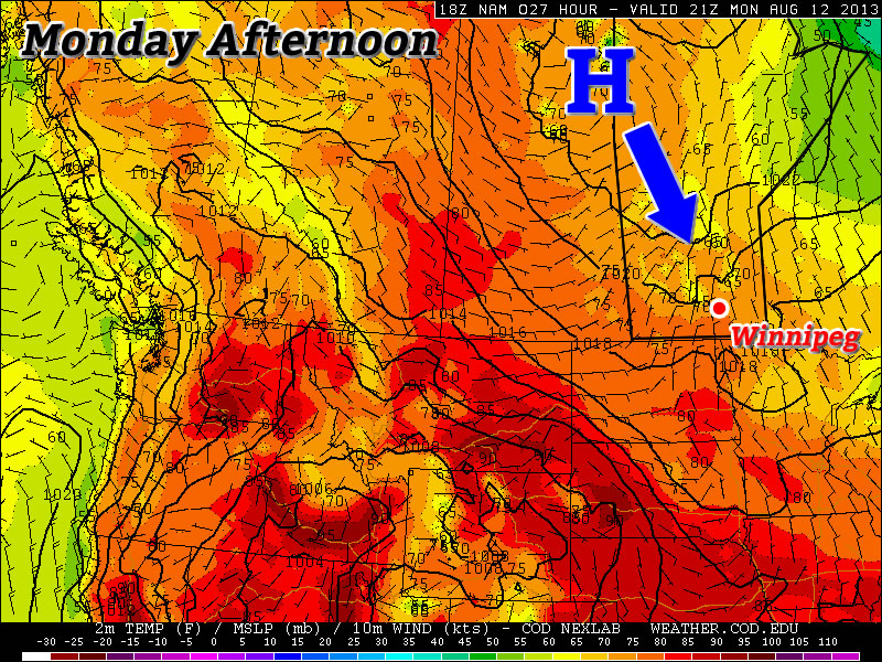
The warmest weather we’ve seen all year is shaping to move in today and persist through the next week as a upper ridge begins to build in over the Prairies. The heat and humidity will be here in full force with daytime highs climbing over 30°C and dew points climbing into the upper teens or even perhaps the low 20’s.

Friday

30°C / 15°C
Mainly Sunny
Saturday

33°C / 17°C
Mainly sunny with a slight risk of a late day thunderstorm.
Sunday

30°C / 17°C
Mainly Sunny

We’ll see beautiful sunny skies today as our temperature climbs to around 30°C. The humidity will become more noticable as the day wears on as the dew point climbs from the low teens to around 17 or 18°C. Temperatures will drop to around 15°C tonight under clear skies.

Tomorrow looks to be a scorcher of a day. The temperature will climb into the low 30’s with high humidity as the dew point climbs over 20°C. It will feel closer to 38–40°C by the afternoon as the Red River Valley bakes in the warmest temperatures of the year. A disturbance will be moving through the Interlake region that will bring a very slight risk of a thunderstorm late in the day, although at this point it looks like most of the activity will stay north of the Red River Valley. Beaches along the South Basin of Lake Winnipeg will have a greater chance of seeing thunderstorm activity than we will here in Winnipeg, so if you’re planning on camping north of the city, that may be something to keep in mind. We’ll have updates below in the comments on the thunderstorm potential tomorrow. We’ll head to an overnight low of aroun 17 or 18°C Saturday night.

Sunday also looks to be a gorgeous day. The hottest weather will be off to our east, but we’ll still see temperatures climb to around 30°C under sunny skies. There will be more of a westerly component to the winds which will help flush out some of the humidity through the day.

Next Week

Next week looks to keep the heat. While the upper ridge flattens thanks to a couple disturbances that move through on the weekend, it’s set to rebound by mid-week, which will keep our daytime highs in the upper 20’s or low 30’s for what looks like the entire week. At this point it looks like we may see some showers or thunderstorms on Monday evening/night, but after that current indications are that it will be hot and dry for the remainder of the week.

After 4 weeks of below-normal temperatures, get out there and enjoy the heat wave! Just be sure to practice some heat safety and wear hats and drink plenty of water. Have a great weekend!

Summer Returns!

After weeks of below-normal temperatures in Winnipeg, we can finally rejoice as summer is set to make a significant return.

Wednesday

25°C / 13°C
Mainly sunny
Thursday

28°C / 14°C
Mainly Sunny
Friday

30°C / 17°C
Mainly Sunny

Describing the next few days will be short and sweet, we’ll see mainly sunny skies, a warm-up returning us to summer-like temperatures and increasing humidity as Gulf moisture is advected northwards in a southerly flow.

The only significant weather to speak of will be a slight chance of a shower or thundershower in the southwest Red River Valley on Thursday morning as a weak area of convection pushes through North Dakota. Other than that slight chance, things should be fairly dry through the rest of the week as well.

The Weekend

This weekend looks exceptinally summer-like as a humid, Gulf-sourced air mass entrenches itself over the Red River Valley. With temperatures in the low 30’s and dew points climbing to nearly 20°C, it’s going to feel more like it’s closer to 36 or 37°C. There will be a slight chance of showers or thunderstorms on Saturday night, but at this point the threat seems marginal at best. It looks to be a dry weekend for the most part with variable cloud cover.

After the weekend we move into a slightly dryer air mass, but the heat sticks around with daytime highs looking to be in the upper 20’s through most of the week.

A Return to Summer?

After several weeks of weather that resembled fall more than summer, we may begin to see hot weather return.

A Surface Ridge of High Pressure Will Slide Southward on Monday

Monday

Monday

Mix of Sun and Cloud. Slight Chance of Showers.
23°C / 6°C

However, before we see hot weather again in Southern Manitoba, we’ll have to deal with yet another burst of polar air. Another surface ridge will drop down from the north on Monday, which will result in reasonable, but still cool conditions. High temperatures on Monday will be in the low twenties, though there may be some readings in the mid twenties along the International border. There might be a few showers around during the afternoon and evening as cool air aloft generates a bit of instability. The wind will generally be light and from the north, though it will be a bit breezier in open areas.

Tuesday

Tuesday

Mainly Sunny
22°C / 7°C

Tuesday looks to be just a slightly cooler version of Monday. Highs will be in the low twenties once again with with a light northerly wind. Shower activity looks less likely on Tuesday, but there may still be some bubbly cloud cover as the ground heats up during the day.

Wednesday

Wednesday

Mainly Sunny
23°C / 10°C

At this point there is a bit of uncertainty as to how warm Wednesday will get. Some weather models suggest we’ll see temperatures in the mid to upper twenties, while others suggest temperatures in the low twenties are most likely. I’m leaning towards the later of those two scenarios, as I don’t think the warm air will move in quite that quickly. As a result, I’m once again calling for temperatures generally in the low twenties with variable cloudiness through the day. The area with the best chance of seeing some warmer conditions on Wednesday will be portions of Western Manitoba where that warmer air may filter in a bit during the afternoon and early evening.

Long Range

The longer range forecast is where things begin to look more promising. Models suggest that we’ll stand a good chance of seeing high temperatures in the upper twenties on Thursday. If we’re lucky, we may take a run at the 30C mark as early as Friday, but that type of heat looks more probable on the weekend right now. There have also been some hints in the models that this heat may also be accompanied by elevated humidity levels. Given that the model I’m looking at for this (GFS) is notorious for being too humid, I’m not going to get overly caught up on this for now. Once we get closer to the weekend, and more accurate information is available, this part of the forecast can be more appropriately addressed.

Elsewhere in Weather News: August 10th, 2013

Potent Heatwave Strikes China; Possible Typhoon on the Way

A prolonged heatwave has been in place for this whole week and even a part of last week over most of Eastern China, including the megacity of Shanghai. An upper-level ridge centered directly over Shanghai (but covering the whole region) is contributing to abnormally high temperatures in the region. Scorching heat, ranging from the high thirties to low forties, covered the whole region while remaining in place yesterday. Numerous heat alerts were issued by the Chinese government urging residents to limit outdoor activities, spend time in air conditioned buildings and most importantly, to stay well hydrated. Unfortunately the death toll had risen to 10 people as of Friday, with Shanghai hardest hit.

China surface temperatures

Map of Eastern China’s surface temperatures for today at 4pm, dark orange is over 36 degrees Celcius. (Source: Wunderground maps)

Such a potent heatwave in this region is not common – it has been said that this one is the worst in 140 years. On August 7th Shanghai broke its all-time record temperature, recording an official high of 40.8°C. Before the recent heatwave began, the highest temperature ever recorded in Shanghai was 40.2°C set in 1934. Shanghai’s average high temperature for August is 32°C. Drought concerns are now coming into play as water sources are starting to run low in the east-central region of China where little to no rainfall is expected in the coming week while the heatwave continues.

The southern coast of China could be under the gun for some drenching rains associated with an incoming typhoon: Typhoon Utor. Utor has still not passed over the Philippines but it is expected to make landfall to the northeast of Manila as a category two. Following its first landfall, it will continue travelling into the South China Sea though there is still a lot of uncertainty as to whether it will curve north into China’s mainland or simply brush the south coast.

Utor

Infrared satellite image of Utor on Friday evening, and it’s expected track. (Source: CIMSS)