After what will be going down in the record books as one of the coldest, if not the coldest, April on record, the weather is poised to dramatically shift gears. After being stuck in “March” for far too long, it looks like we’re poised to skip right over “April” and shift into “May” in very short order.

850mb temperatures from the NAM show temperatures approaching 15°C advecting into Southern Manitoba on Saturday morning.
Southern Manitoba has been locked in March-like weather temperatures routinely 8–12°C below normal as a persistent northwest flow aloft has continually reinforced the Arctic air mass sitting over the region. This has led to some impressive new records including the latest date in the year that Winnipeg has hit it’s first +5°C temperature. This has led to a substantial snowpack remaining through the Red River Valley and we’re on our way to the latest flood peak for the Red River; in Winnipeg the Red is expected to peak in late-May, 1–2 weeks later than the previous latest-peak on record which was May 19, 1950.
We’re set to bust out of the cold, though, as a huge shift in the upper-level pattern is on the way.
 2°C
2°C /
-10Scattered flurries in the morning. Mix of sun & cloud.
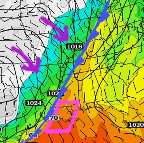
Today will continue our trend of cool weather as yet more cold air will be descending southwards through the province. A cold front will pass through Winnipeg in the morning and through the Southern Red River Valley in the afternoon. The cold front will likely have some scattered flurries along it as it pushes through in the morning and then develop more organized, heavier convective flurries along it in the afternoon, south and east of Winnipeg. There will be a very slight chance of some light flurry activity behind the cold front, but that will be minimal as the atmosphere quickly stabilizes behind the front despite daytime heating. Skies will clear out through the afternoon and we’ll be headed to a chilly –9 or –10°C tonight.
Thursday & Friday
A huge change is on the way for the end of the week. The high over low block we mentioned last week will finally break down as the cold low associated with the feature ventures towards the Central Plains of the United States. The upper ridge begins to collapse over the Eastern Pacific and the upper flow rapidly breaks down and becomes zonal, dramatically shifting storm tracks. By Wednesday evening, a new low will already be moving into Northern Alberta. Over the past few weeks, stuck in a northwest flow, such lows would generally slice SE through Saskatchewan and push into the States before reaching Manitoba. Under this new flow regime, though, this low will push through Central Manitoba instead, helping pull warmer air into southern portions of the province. Just how warm, you ask?
Thursday 8°C
8°C /
-2°CMainly sunny.
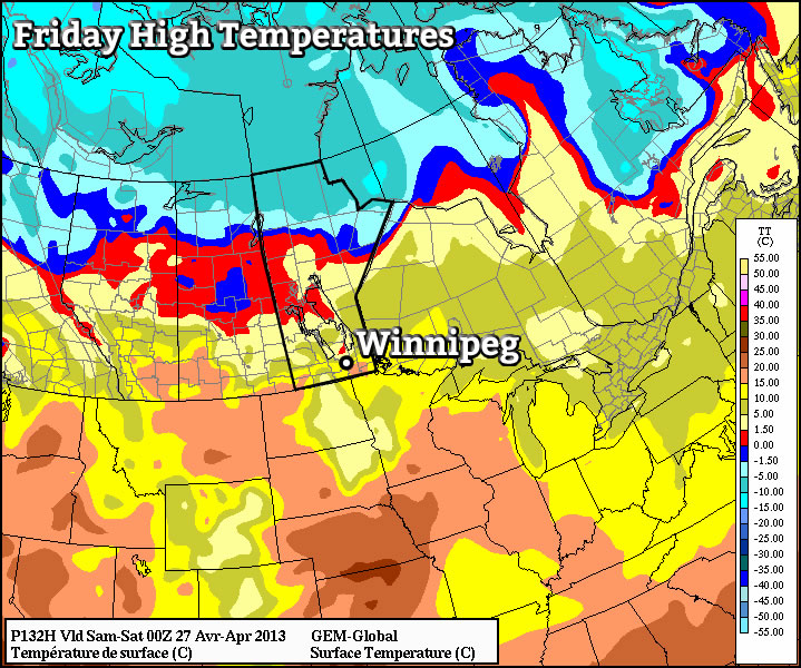
Friday 15°C
15°C /
3°CSunny.
Temperatures will soar over the next few days as warm air that not even the snowpack can fight against floods it’s way northward. We’ll see temperatures climb to 7 or 8°C Thursday as the southwest flow sets up and the warm air is able to start pushing into Southern Manitoba and then see temperatures be close to double that on Friday as we get deep into the warm air. No precipitation is expected either day.
Long-Range
It looks, more or less, like warmer air is here to stay. Warm air will continue to build into the province through the weekend pushing temperatures closer and closer to the 20°C mark. We’ll likely have a couple nights with lows well above 0°C. A disturbance will return cooler air to the province at the start of next week, but it’s not expected to stick around for too long.
Flood Concerns
Flooding concerns will arrive en masse with the warmer weather. The dramatic and intense warm-up, combined with a high likelihood of overnight lows above 0°C this weekend mean that the remaining snowpack will undergo rapid melting. Some overland flooding should be expected, and anybody living near rivers or streams should expect them to swell quickly this weekend into the beginning of next week. In Fargo, the Red River is expected to rise from 20’ on Friday night to around 32’ by Monday morning. The Red River isn’t expected to peak in Winnipeg until late May, but one thing is for sure: the water will be flowing by the end of the weekend all over the Red River Valley, so be sure to take adequate precaution when around swollen rivers or streams.
