More Snow on the Way

sigh

image

850mb wind forecast showing the deep southerly flow that will be providing the moisture and lift for today’s system.

Today

image
0°C / -2°C
Snow beginning this afternoon. 2-4cm overnight.

A frontal wave sliding across the Prairies will push into Southern Manitoba this morning, spreading snow eastwards across the Red River Valley this afternoon. While southwestern Manitoba will see 5–10cm of the white stuff, we should fare a little better here in the RRV with 5cm expected near the US border tapering off to 2–4cm here in Winnipeg. The bulk of the snow will fall this evening into the overnight period before tapering off late overnight or early tomorrow morning.

Saturday & Sunday

Saturday
image
1°C / -11°C
Cloudy with a chance of flurries. Clearing late in the day.
Sunday
image
-4°C / -14°C
Increasing cloud. Light snow beginning in the afternoon.

Saturday will be a bit of a mixed bag with some lingering flurries in the morning and gradual clearing in the afternoon before skies clear late in the afternoon or evening. The high temperature on Saturday should be around 1°C and we’ll see temperatures drop to –11 or –12°C Saturday night.

More snow looks to be on the way for Sunday afternoon as an Alberta Clipper slides along the international border. At this point, it doesn’t look like a significant system, but it should pack enough of a punch that it will likely drop a couple cm through the RRV in the afternoon. After Sunday, it looks like we’ll slip back into another benign pattern with below-normal temperatures as a surface ridge keeps snowier weather to our west and to our south.

Warmest Day of Spring So Far Will Also Be Most Unpleasant

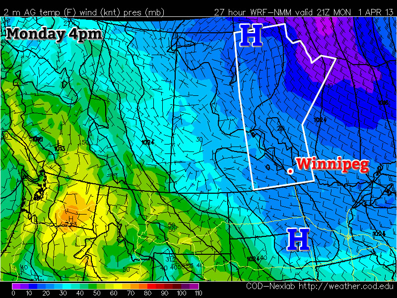
It’s almost a certainty that Winnipeg will record the warmest day so far this spring at it’s official reporting station at the airport, but it will without question be perhaps one of the most unpleasant feeling days of the past couple weeks as a low pressure system moves through.

3hr. QPF valid this afternoon.

RDPS output showing a weak band of flurries pushing across the RRV this afternoon.

Today


3°C / -9°C
Cloudy & windy. Chance of flurries midday onwards.

A low pressure system will be tracking through Southern Manitoba today, bringing with it a mass of very warm air. Temperatures at the surface will climb to around +3°C today despite our 850mb temperatures climbing nearly 20°C from yesterday’s values. Thanks to the significant push of warm air aloft moving into the Red River Valley, our winds will be blowing quite strong today out of the south. The winds should sit around 40km/h with gusts to 60km/h through much of the morning, although it’s possible that winds will strengthen beyond that with gusts as high as 70–75km/h.

In addition to the above-zero temperatures, our dewpoint is expected to climb above zero as well. The above-zero temperatures combined with above-zero dewpoints will prove to be one of the more effective melting days we’ve seen so far this year despite the absence of sun with substantial warming of the entire snowpack possible. We may see some flurries as the cold front pushes through in the afternoon, but current indications are that the air coming in is a little to dry to produce much precipitation. Before the cold front comes through, the thermodynamic profile looks relatively favourable for drizzle, but I think that the strong winds will prevent its development. All in all, despite the warmer temperatures, today will end up a cloudy, damp, windy chilly-feeling day.

Once the cold front pushes through mid-afternoon, we’ll see winds lighten and slowly shift to westerlies while gradual clearing occurs. Temperatures will drop to around –9°C tonight under clear skies.

Thursday & Friday

Thursday

-2°C / -14°C
Mainly sunny.
Friday

0°C / -8°C
Mainly sunny. Increasing cloud overnight with chance of flurries.

We’ll return to a benign pattern for the rest of the week as another Arctic ridge builds into the Prairies. We’ll see plenty of sunny skies and highs near or just under 0°C while overnight lows sit around –14°C on Thursday night and warm to just –8°C on Friday night as clouds begin to move in ahead of the next low pressure system. Winds will remain light through Thursday and Friday.

The Weekend

Models are having difficulty resolving exactly what is going to happen with the next system headed our way for late overnight Friday into Saturday. American models are keeping it well to our south, the Canadian models are clipping it through SW Manitoba and the far SW portions of the Red River Valley, while the European models are bringing it through the Trans-Canada corridor, including Winnipeg. While the European models tend to have higher skill than the North American models at long-range (primarily thanks to their relentless efforts to initialize the models as well as they possibly can), the solution doesn’t necessarily make a whole lot of sense to me.

We’ll be watching this system develop over the next few days, and while it seems likely that some snow will fall this weekend over SW Manitoba, it’s still too early to call for Winnipeg or the RRV; we may see nothing or another 5–10cm of the white stuff. At this point, regardless of where it goes, it doesn’t look like a major system that will drop too much water (ensemble solutions are pointing towards 5–10mm of liquid equivalent with this system).

Long-Range

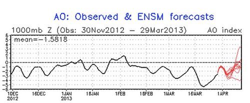
This cool weather of late has many people asking when spring will arrive. Our snowpack is abnormally deep for this time of year, March started off warm but just got colder and colder as time went on, and we have yet to even start the widespread snowpack melt. All this is certainly compounded by memories of last March’s weather, where we had the warmest March on record at 2.2°C, 0.6°C above the previous record.[1] Fortunately, there is some hope on the horizon.

AO Graph

AO values over the past few months. A quick flip from negative to positive values is expected, denoted by the forecast red line.

The Arctic Oscillation (AO), a large-scale weather pattern that can impact the distribution of cold air through the Northern Hemisphere, has been locked below zero for quite some time now. When the AO value is negative, it usually results in a stationary pool of cold air over central continental North America, as we’ve seen over the past few weeks. This has brought below-normal temperatures to many locations across the Prairies and northern United States. The good news is that, as seen above, the AO values are expected to sharply shift into the positive over the next two weeks, which should allow the jet stream to start pushing northwards and bring warmer weather to our region. So while the cooler weather will likely be here for the next 7–10 days at least, a significant change in the weather pattern looks like it’s on it’s way in the near future.


  1. Check out the mentioned link for a list of the 9 significant records we broke in March 2012.  ↩

Major Warm-Up To Start April

It look like a major warm-up will usher in the month of April. These warmer conditions come after an abnormally cold March.

image

High pressure will dominate at the surface on Monday (College of Dupage image)

…April fools! No major warm-up is in the cards this week, so read on to see what you can actually expect.

Monday

Monday
image
Mix of sun and cloud. Chance of flurries.
-6°C / -12°C

Monday will be a very similar day to Sunday. The lower atmosphere will once again be quite unstable, so flurries will be possible throughout Southern Manitoba. These flurries will be fairly localized in nature and will not affect everyone. Those areas not under the influence of these flurries will see a mainly sunny day, while other areas will see a combination of clouds and flurries as well as periods of sunnier skies. Generally speaking, high temperatures will be in the mid to upper minus single digits, making it a seasonably cold start to April.

Tuesday and Wednesday

Tuesday
image
Mainly Sunny
-4°C / -8°C
Wednesday
image
Mix of sun and cloud. Chance of flurries.
2°C / -10°C

Tuesday will be slightly warmer than Monday, but not by much. Highs will be in the mid single digits in most areas. The wind will be calm and the sky sunny, so the cities and forested areas will once again be slightly warmer than everyone else.

We will finally warm up to the melting point again on Wednesday, but it won’t be a major warm-up. All of Southern Manitoba should see high temperatures in the low to mid positive single digits.

Long Range

In the longer range models are struggling to resolve the pattern. It appears fairly certain that a cold front will come through on Wednesday night, making Thursday a cooler day once again. However, beyond that things are quite unclear. Some model runs have been showing consistently warmer weather into next weekend, while others have shown cold weather persisting. We’ll just have to wait and see what happens…

Elsewhere in Weather News: March 30th, 2013

Europe Battles Cold

This past month it has not only been Southern Manitoba dealing with pesky cold Arctic air lingering around while the spring thaw should be starting up, most of Europe has also been under significantly below normal temperatures for the month of March. What has been bringing such cold weather can be attributed mostly to the same reason why we’ve been getting such cold; a negative NAO (North Atlantic Oscillation) pattern. This is cause for Scandanavian highs staying put and bringing down some unseasonably cold air from the north-east in Europe’s case.

NAO

Graph of the NAO showing values of below zero for the whole month of March. (Source: NCEP)

Germany has had the worst of the cold in Europe with their average March temperature 4°C below average – the coldest ever since record keeping started in 1883. Other parts of Europe were generally 3°C below average for March. To add to the cold temperatures, Europe has been faced with a few significant snowstorms this month, such as last week’s snowstorm that caused hundreds of flight cancellations and even the closure of Frankfurt’s International Airport. The reason for these significant snow events this late in the season can be attributed to a low pressure system drawing in moist air from the North Mediterranean. This, when combined with the stationary Siberian high feeding cold air into the northern half of the low, makes for ideal snowy conditions.

Low pressure system, Europe

Low pressure system making it’s way across Europe and bringing with it snow. Heavy snow in areas outlined in purple, thanks to cold air being brought down by the Scandanavian high.

The Scandanavian high looks to stay put over the region for just a little less than another week, however, with the NAO trending upwards and with the sun getting stronger every day (we are now at the equivalent of a September sun), this means that warmer temperatures are on the horizon for most of Europe for the second week of April.