Benign Weather Continues

We’ll continue to chip away at the cold air and push towards seasonal temperatures over the next few days as the ridge of high pressure anchored over the province slowly weakens.

Friday

Mainly sunny. Increasing cloud overnight.
-7°C to -3°C / -14°C
Saturday

A mix of sun and cloud.
-3°C / -12°C
Sunday

Becoming sunnier than cloudy.
-3°C / -13°C

We’ll see mainly sunny skies today as temperatures climb from anywhere to -7°C on the northwest side of the city to closer to about -3°C downtown. Some cloud will start pushing into the Red River Valley from the east tonight which will limit our overnight low to only around -14°C instead of dropping back into the -20’s again. Saturday will see more cloud than sun with temperatures climbing to around -3°C and dropping to slightly below -10°C Saturday night. The clouds will start to break up on Sunday; we’ll likely see more sun than cloud through the late morning and afternoon period as the temperature climbs up to around -4°C yet again.

Long Range

Current indications for the next week or so are that not much will change; no large systems are in our forecast which will certainly be a help to the flooding situation. Days just below zero combined with the strong March sun and no additional precipitation are excellent for helping with the potential flood situation by melting the existing snowpack at a gradual pace.

Sunny & Climbing Towards Seasonal

Winnipeg & the Red River Valley will spend the rest of the week struggling back towards seasonal temperatures as an abnormal mid-March blast of cold, Arctic air has left us significantly below our normal temperature of around 0°C.

Wednesday

Mainly sunny.
-10°C / -21°C
Thursday

Mainly sunny.
-7°C / -16°C
Friday

Mainly sunny.
-5°C / -10°C

Very little is expected to change over our region through the next three days. The low that brought the blizzard to Southern Manitoba at the beginning of this week has stalled out over Ontario and while another low will be deepening in Alberta, everything will be somewhat “stuck” and we’ll remain under the ridge of high pressure between the two systems. With little motion and us sitting right under a ridge, winds will remain light and very little temperature advection will be occurring aloft. The upside to this situation is that we’ll see plenty of sun through the remainder of the week, and since that sun is now a late-March sun, it will be able to slowly work at warming up that big mass of air stuck over us. Thanks to this, temperatures will slowly rise through the week back towards more seasonal temperatures. While it may not be as warm as we’d like, you can at least get out there and enjoy the sunshine, light winds, and feel that sun working!

The Weekend

At this point, the weekend looks fairly benign: temperatures will climb close to 0°C for daytime highs and there’s a chance we’ll see some light snow on Saturday or Sunday. At this point, no significant storm system is expected, but we’ll keep our eyes peeled! Hopefully we’ll be able to close the book on this winter very soon.

Not a Great Start to the Week

This week hasn’t exactly started out on a pleasant note as you’re no doubt aware. Unfortunately, conditions won’t improve much after today.

image

Predicted conditions early Monday afternoon (courtesy: College of Dupage NAM model)
Monday
image
Snow ending. Blowing snow.
-12°C / -21°C

Monday

Snow and heavy blowing snow is currently ongoing in parts of the Red River Valley. This snow and blowing snow will gradually taper off today, but not before snow totals of 10 to 20cm have piled up across Southern Manitoba. High temperatures today won’t be very pleasant, nor will low temperatures tonight. Overall a horrible start to the week.

Tuesday and Wednesday

Tuesday
image
Mainly cloudy
-12°C / -22°C
Wednesday
image
Mix of sun and cloud
-11°C / -21°C

Conditions on Tuesday will see little improvement from Monday. Highs will once again be very cold by March standards. Luckily no more precipitation is expected on Tuesday (except maybe a flurry here or there), which is at least something to be thankful for. Wednesday will again be a seasonably cold day, with no weather of note.

Long Range

The long range is…you guessed it, ugly. At this point the GFS model (a longer range model) doesn’t show us even getting to the freezing mark in the next ten days. While this may be an overly pessimistic forecast, it is certainly possible given the extensive snowpack over the Eastern Prairies. We can only hope it is wrong, and perhaps we’ll see at least some melting, however minimal, by the weekend.

A Cold Weekend To Close Out With More Snow

The cold front that pushed through last night will usher in a reinforcing shot of Arctic air which will drop our temperatures back below-normal for the next few days. The weather will remain fairly benign until Sunday when a potent inverted trough low-pressure system will bring snow to Southern Manitoba.

Friday & Saturday

Friday
image
Mostly cloudy with light scattered flurries. Clearing overnight.
-13°C / -21°C
Saturday
image
Sunny.
-11°C / -21°C

We’ll see mainly cloudy skies today with some light flurries scattered through the Red River Valley. Temperatures will be quite cool with a brisk northerly wind limiting our daytime high to only –13°C as it ushers Arctic air into Southern Manitoba. Skies will slowly clear out overnight as we head to an overnight low near –21°C. On Saturday we’ll see sunny skies with light winds and a high near –11°C. Temperatures will drop back to around –21°C again Saturday night under clear skies.

Sunday

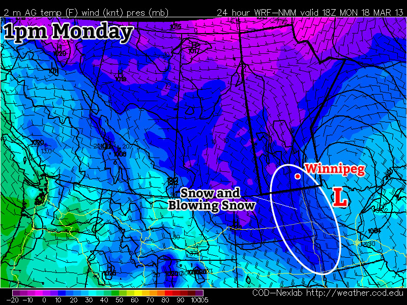
Sunday will be the most active weather day we’ve had in Southern Manitoba in a while. An inverted trough will push into Southern Manitoba through the morning hours with snow beginning over SW Manitoba through the morning and moving into the Red River Valley by the evening. Right now it looks like this system will develop in a somewhat complex manner; a low pressure system will push out of Montana and intensify as it moves into South Dakota and taps into moister air over the Central Plains. This moisture will surge northwards ahead of the low, which will be rapidly evolving as it interacts with a strengthening shortwave travelling along the MB/ND border. The low will rapidly develop a sharp inverted trough and feed plenty of moisture into it. This is not dissimilar to the setup earlier this month that brought 2 feet of snow to some communities in the SW Red River Valley, but at this point it does not look like this system will be nearly as potent.

Liquid-equivalent precipitation amounts from the GDPS from Sunday morning to Monday morning.

Liquid-equivalent precipitation amounts from the GDPS for Sunday morning through Monday morning.

At the moment, it appears that most communities near the International Border (from Melita all the way to Emerson) will see between 10–20cm of snow; regions near the western escarpment of the Red River Valley may see an additional 5–10cm above that figure due to localized upslope enhancement from the easterly/northeasterly winds that will set up with this inverted trough. Further north in communities along the Trans-Canada Highway (Brandon, Portage la Prairie, Winnipeg), snowfall accumulations will be quite a bit less. Currently it looks like around 5–10cm can be expected, diminishing to closer to 5cm in the Whiteshell. This is simply a first guess, though; this system may end up developing in a completely different manner should only a few small things change. I’ve erred on the side of caution, giving what I think is a “worst case” scenario. Snowfall amounts could very well be less than mentioned here; we’ll provide an update tomorrow in the comments below updating what this system looks like it’s doing, along with a snowfall forecast map.

Next Week

This system will push off into Ontario on Monday and we’ll begin a slow trek back towards seasonal temperatures through the rest of the week. With warmer air trying to push into the province, it looks like we’ll have several chances to see more snow with as a more unsettled pattern develops.