Clouds To Start Breaking Up

The overcast weather will begin to break this weekend as a system tracking through the central Prairies brings drier air eastwards across the Prairies. Temperatures will cool off with the clearing skies, but the sun will be a welcome sight that may make many not care.

Snow in Assiniboine Park

A snowy, overcast scene at Assiniboine Park, courtesy “Mentally Guitarded.”

Clouds will stick around for today with continued periods of light snow as temperatures continue to remain in the optimal snow-generating range. Winds will be light out of the south as we reside on the back-side of a ridge which passed through overnight and temperatures will climb to around -11°C. As a low pressure system tracks across the Prairies tomorrow, higher-level cloud will begin to stream over Southern Manitoba. This mid-cloud will help produce scattered snow showers in areas that have been socked in with low cloud for a while, but also begin to dissipate that persistent low cloud as well.

On Saturday we’ll likely see a mix of sun and cloud as more mid-level cloud streams over the southern portion of the province. There should be some sunny breaks as well and temperatures will climb once again to around -12°C. Clouds will break up a little overnight as cooler air pushes in from the northwest behind this system and we’ll head to an overnight low closer to -20°C. By Sunday, we should see a little more sun than on Saturday with temperatures climbing only to around -16 or -15°C. No significant snow accumulations are expected through the weekend.

Next week, including Christmas, is looking fairly sunny and cool, with overnight lows near -25°C and daytime highs near -18°C. We’ll be taking a slight vacation over Christmas here at AWM, so have a great holiday and a happy new year!

Snow Today, Cooler For Week’s End

Light snow will very slowly taper off through the day today, leaving us with slowly clearing skies and cooler weather.

NAM Sounding valid 4PM Wed Dec 19

A sounding from the NAM for Winnipeg valid at 4PM today. The areas of the line that are coloured yellow denote effective snow making regions in the atmosphere (a combination of temperature & humidity).

Light snow that pushed into the Red River Valley overnight will taper off this evening; despite the fact that the system will be pushing out of the province mid-day, the temperature structure of the lowest 2-3km of the atmosphere will remain highly favourable for the generation of snow, so we’ll likely see additional snowfall through the day today similar to Monday. In total we’ll likely see 4-8cm of new snow through the Red River Valley. Clouds look to begin to break up overnight leading to a cooler night than we’ve had lately with temperatures dropping to around -15°C.

Thursday will bring mainly sunny skies with very little temperature recovery; daytime highs through the RRV will be only -14 or -13°C. The clear skies look to persist through week’s end as cooler air continues to push into the region: overnight lows on Thursday night will drop another couple degrees to about -18°C while temperatures look to climb to only around -15°C again on Friday.

The weekend looks clear but cool, with overnight lows near -25°C and daytime highs near -20°C.

A Seasonal Start To The Week

Seasonal temperatures will be in place for Winnipeg & the Red River Valley for the start of the week as a continued weak southerly flow keeps the Arctic air locked up to our north.

The CMHR on a Snowy Winnipeg Morning

The Canadian Museum for Human Rights on a snowy Winnipeg morning.

Temperatures will sit near -10°C today through Winnipeg & the RRV, perhaps climbing up to -9 or -8°C briefly. We’ll see light snow through much of the morning with a chance for it to redevelop this evening for a few hours. Accumulations will sit around 2-4cm from this very light, fluffy snow, but it will likely have significant impact on roadways. Combined with the warmer temperatures, fog, and patchy freezing drizzle, some roads in Winnipeg and some provincial highways are already quite icy. As this light, fluffy snow is driven on, it tends to compact to a thin layer of ice; this will likely make it so that some highways, including the Perimeter Highway, side-streets and intersections are quite slippery by the evening commute. Be sure to leave yourself some extra time if you need to drive this evening.

Temperatures will remain fairly steady tonight or even climb a degree or two and another push of warmer air moves in. Once again we’ll likely see dense fog patches and patchy freezing drizzle redevelop tonight as this warm air advances towards the RRV.

Tomorrow, temperatures will climb to about -5°C with scattered flurries through the RRV. Winds will remain light, so it will be another great day to get outside. Some light snow will move through Winnipeg & the RRV tomorrow evening/night as a weak disturbance passes to our south. We’ll get another 1-2cm of snow as temperatures drop back towards -10°C.

Wednesday looks to be almost a carbon copy of today, with some light snow and highs around -9°C. The rest of the week is a little more uncertain; models all hint that the upper-level flow pattern will begin to break down, but how quickly that will happen is uncertain still. While the next few days will almost certainly be cloudy, we’ll probably see the sun start to make an appearance later in the week, if not having the clouds completely clear out. We’ll have more details on the second half of the week on Wednesday.

Elsewhere in Weather News: December 15th, 2012

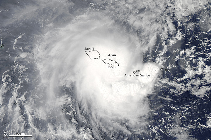
Tropical cyclone Evan struck the Samoan Islands on December 13, bringing strong winds and heavy rain to the area.

NASA's Aqua satellite captured this image of Evan as it struck Samoa

NASA’s Aqua satellite captured this image of Evan as it struck Samoa (Source: http://earthobservatory.nasa.gov/NaturalHazards/view.php?id=79989&src=nha)

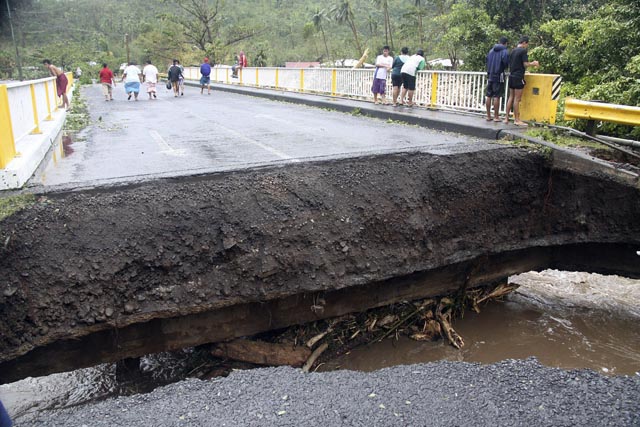
Evan was a category 1 cyclone when it struck the Samoan Islands region on Thursday, with maximum sustained winds of 144km/h. The storm came onshore near Apia, the capital of Samoa, and the country’s largest city (population 37,708). The cyclone destroyed buildings, ripped up trees, and took down phone, internet, and electricity services across Samoa. In addition, the heavy rain generated by Evan caused widespread flooding. The death toll from Evan is at least 2, with the cyclone being called the worst in many years by local residents.

People walk over a destroyed bridge in Samoa's capital Apia, Friday, Dec. 14, 2012

People walk over a destroyed bridge in Samoa’s capital Apia, Friday, Dec. 14, 2012 (Source: http://www.wunderground.com/blog/JeffMasters/article.html?entrynum=2311)

Evan has taken an unusual track so far, first moving eastward toward Samoa, then making a 180 degree turn over the islands, with its track now taking it westward toward Figi. Evan is currently intensifying, with maximum sustained winds presently at 185km/h. That is high enough to make it a category 3 cyclone on the Saffir-Simpson scale. Current forecasts suggest that the cyclone could approach category 5 status (winds >252km/h) this weekend, before hopefully weakening somewhat prior to affecting Figi. Despite its expected weakening trend ahead of hitting Figi, Evan could become a major disaster for the country, with the country’s leader Commodore Frank Bainimarama’s quoted as saying the following “Fellow Fijians I cannot stress how serious this is, every Fijian will be affected”. Figi is a small country consisting of 332 islands with a population of approximately 850,000.