Another Shot of Snow on the Way

More snow is on the way for Southern Manitoba this weekend as a low pressure system moves across the Dakotas.

NAM Precipitation Accumulations for Saturday

NAM liquid-equivalent precipitation accumulations for Saturday afternoon/evening.

It will be a cool day across the Red River Valley today as any left over cloud moves out, allowing our temperatures to slowly drop to around -16°C by this afternoon. Temperatures will dip down to around -21°C tonight before some cloud associated with the approaching low pressure system moves in.

Snow will spread into southwest Manitoba tonight and reach the Red River Valley tomorrow morning. It will last through much of the day before tapering off in the evening. One of the main challenges with this system is it’s complex nature: the feature pushing across Southern Manitoba is known as an inverted trough. These complicated features are notorious for being difficult to forecast the snowfall intensities they’ll produce.

In general, it looks like the heaviest snowfalls will be along and south of the Trans-Canada Highway, including Winnipeg, with an average of 5-10cm. There are some hints within the model outputs that some areas may see as much as 10-15cm, however it’s a little hard to say that with confidence since there is absolutely no developed reflection of how this system is taking shape right now. The area that is most likely to potentially exceed 10cm of snowfall is in extreme SE Saskatchewan into SW Manitoba, west of the RRV and south of the TCH. At this point, it looks likely that Winnipeg will see 5-8cm of snow tomorrow.

Skies will clear across Southern Manitoba tomorrow night, bringing another cold night to the Red River Valley with overnight lows dipping to -20°C. Sunday will be mainly sunny with a high of about -15°C.

Freezing Rain to Mark Return of Colder Weather

Our wild weather will continue as another low pressure system tracking through the northern Prairies will bring with it mild temperatures and the probable risk for freezing rain over the Red River Valley, including Winnipeg.

Sounding for Winnipeg @ 5:00PM Local Time

Sounding for Winnipeg at 5:00PM local time. Note the significant AFL shaded in red.

Warm air will be pumped over the Red River Valley today as strong southerly winds develop ahead of a major low pressure system set to bring heavy snowfall to the northern reaches of Manitoba. 850mb temperatures will climb to nearly +5°C today, providing an ample AFL[1]. The bulk of the precipitation with this system will be constrained to central and northern Manitoba, where anywhere from 5–20cm of snow are expected. Regions that were hit hard Monday will mostly be spared as the heaviest snow will fall further north than Monday’s system.

We’ll have breezy southerly winds in the Red River Valley today at around 40km/h with gusts to 60km/h with temperatures climbing all the way up towards –1°C by the late afternoon/early evening. As the warm front approaches the RRV in the late afternoon, it looks that an area of showers will blossom along it. There’s still some uncertainty in exactly where the precipitation will be and how quickly it will develop, but it looks probable that areas in the Red River Valley north of Morris will see freezing rain late this afternoon. Areas south of Morris have a very real chance as well, however there’s a little more uncertainty in how far south the band of showers will stretch.

We aren’t expecting huge amounts of freezing rain this afternoon; the quick-moving nature of this system will mean that even if the rain is intense, it’s likely that we’ll only 1–2mm of it. Keep in mind, though, that while 1–2mm isn’t a very significant amount for regular rainfall, it is a significant amount of freezing rain. It’s likely that the freezing rain will fall during the rush-hour period in Winnipeg and quickly turn roads into slick little skating rinks fairly quickly. If you drive to work, especially into or through the downtown core of Winnipeg, expect a slow commute this evening.

Skies will clear overnight as a weak cold front pushes across the RRV and Thursday will bring mainly sunny skies with temperatures falling through the day to –8°C by evening.. Winds will be breezy from the NW at about 30km/h before letting up in the afternoon. Another arctic ridge will push into Southern Manitoba, bringing another shot of cold weather with it. Temperatures will dip all the way to around –20°C on Thursday night and only recover to around –15°C on Friday.

Temperatures will level out a bit for the weekend with highs near –10°C for Saturday & Sunday, but it looks that a weak storm track will move over us, bringing cloudy skies and plenty of chances for light snow. We’ll have more on this weekend’s weather on Friday morning.

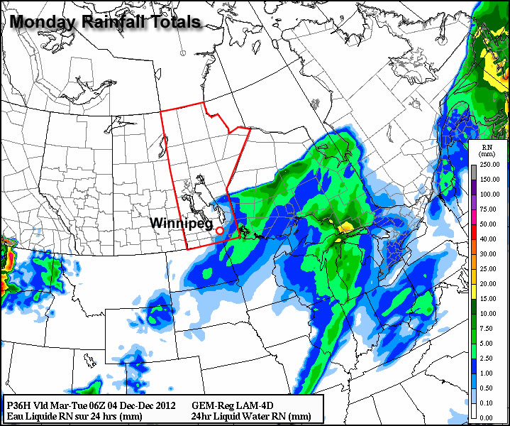
Northern Manitoba Communities Buried Under Massive Snowfall

An incredibly powerful low pressure system tracking through Northern Manitoba on Monday brought a nearly unprecedented snowfall event to many communities. Hardest hit were Norway House and Gods Lake Narrows[2] where over 2 feet of snow fell. Environment Canada sent out a brief summary yesterday on the event:

A major winter storm moved across Central Manitoba on Monday, bringing with it some very heavy snowfalls. The heaviest band fell from the Norway House area east to the Ontario border, with numerous public reports of knee- to waist-deep snow accompanied by drifting as high as two metres. Lesser but still significant amounts were received by the surrounding regions of Gillam, Grand Rapids, and The Pas.

Unofficial snowfall totals are as follows:

Location Snowfall
Norway House 60–90 cm
Gods Lake Narrows 60–90 cm
Island Lake 60 cm
Oxford House 45 cm
Cross Lake 30–40 cm
Gillam 35 cm
Grand rapids 30 cm
The Pas 30 cm
Mafeking 23 cm

While official snowfall records for northern Manitoba are hard to come by, it seems likely that these snowfalls are record-high snowfalls for a 24–36 hour period for Norway House, Gods Lake Narrows, and Island Lake. From what I could find, 1-day record-high snowfall totals in Northern Manitoba generally sit around the 40–50cm mark; these totals of 2–3 feet easily quash those records, and whether or not they end up as official “heaviest snowfall” records may come down to exactly how much fell in any given 24-hour period.

Norway House Snowfall Satellite Image

A visible composite satellite image from during Norway House/Island Lake snow storm.

The snowfall came from an extremely potent, moisture-laden low pressure system that managed to find the right combination of convective snowfall and duration. As shown in the satellite image above, a very strong moisture feed was evident as it surged northwards into the low pressure system rooted near The Pas. This system slowly tracked eastwards, producing heavy snow in the above localities for upwards of 18–24 hours.

A system like this is definitely an extremely uncommon one and is difficult to forecast due to the sparseness of surface observations and lack of RADAR imagery. It will likely be just now as this is published that some roads finally begin to be cleared and people are able to return to a more normal daily routine.

A further 5–10cm of snow is expected for the Norway House and Island Lake regions with the system passing through Manitoba today.


  1. Above Freezing Level  ↩
  2. Gods Lake Narrows is a small community north of Island Lake, MB.  ↩

Weather Roller Coaster

This week will be a bit of a meteorological roller coaster as our temperatures climb up, then fall rapidly back down again.

GEM-Regional predicted rainfall total for Monday

GEM-Regional predicted rainfall total for Monday

Monday looks to be the warmest day of the week with above freezing temperature of 1 or 2C expected in Southern Manitoba. Some light rainfall is expected in south-eastern parts of the province out ahead of a cold front. This may lead to icy conditions on Monday night as temperatures drop below zero behind the front. Winnipeg will be right on the edge of this area of rain, so the city isn’t expected to see more than a millimetre or two of rain at most. In fact most models take the area of rain just south-east of Winnipeg, so the northern part of the Red River Valley may end up with no precipitation at all. Temperatures will plummet on Monday night in the wake of the cold front with values dipping down into the minus double digits by Tuesday morning.

High temperatures will remain down in the minus teens in Southern Manitoba on Wednesday, with most areas in the -11 to -14C range. A weather system emerging from the mountains in Alberta will develop a southerly flow over Manitoba on Tuesday night. As a result, Tuesday night will be characterized by increasing warm air advection, allowing for warmer air to filter into Southern Manitoba during the overnight period. We will continue to experience warming on Wednesday as a stiff south wind continues to bring in warmer air. Unfortunately, the wind will be very strong, making conditions much less comfortable than the temperature alone would indicate. Highs on Wednesday will be in the low to mid minus single digits in Southern Manitoba, but wind chills values will be in the -10 to -15 range due to the strong south wind.

Another cold front will move through on Wednesday night or Thursday, setting up a chilly end to the week. No significant precipitation is currently in the forecast for Southern Manitoba this week as the main storm track remains to our north and west.

Elsewhere in Weather News: December 1st, 2012

Typhoon Bopha Takes Aim at the Philippines

A strong typhoon dubbed Bopha has spun up in the Northwest Pacific Ocean this past week and is taking aim at the Philippines. The typhoon is currently located at 4.5°N which means that it’s still located within the Intertropical Convergence Zone (ITCZ). This is an area north and south of the equator where north-east and south-east winds meet and cause daily convectional thunderstorms. Near the equator, there is little Coriolis effect which would explain why tropical cyclones rarely form (lack of spin). Since Bopha will move towards the west north-west, it will hold together. If it were moving towards the equator, it would be less likely that it would maintain form.

Typhoon tracks

All typhoon tracks between 1985 and 2005 with equator and Bopha’s approximate location (pink). (Source: Wiki Images)

Bopha

Bopha’s basic into from Friday night, it’s expected track and strength. (Source: Humanitarian Early Warning Service)

It’s expected that Bopha will strike south of Manila and likely make landfall on the Island of Samar on early on Monday, December 4th. It is likely to be a violent typhoon, bringing severe storm surge, copious amounts of rain to areas that are prone to mudslides and flooding. Winds will almost certainly be a problem as it’s predicted that Bopha will make landfall as a category 3, accompanied by winds around 200km/h. As of Friday evening the storm already had a central pressure of 965mb with sustained winds near 200km/h. On Friday evening, it was quickly intensifying with very cold cloud tops around its centre and a well-defined eye was starting to develop.

Microwave imagery - Bopha

Microwave imagery from Bopha on Friday night. The eye was becoming well defined. (Source: CIMSS)

IR Satellite - Bopha

Infra-red satellite imagery from Bopha as a category 4 hurricane. (Source: CIMSS)

On average, the Philippine Islands see an average of 9 hurricanes make landfall annually, with 1-2 usually developing in the month of December. Their peak season for typhoon activity runs at about the same time as the Atlantic Hurricane Season, though it’s not unusual to see typhoons in that area after November 30th.