A Scorching Week to End With A Bang

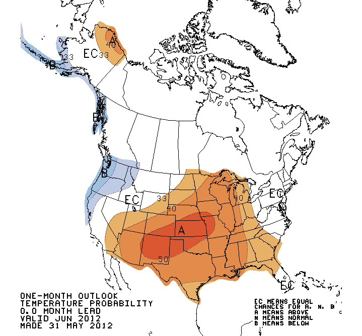
Temperatures are set to soar for the remainder of this week as heat sourced from the Gulf of Mexico builds into Southern Manitoba. Residents across all of Southern Manitoba should begin to prepare for a potentially dangerous end-of-week though, as a powerful low pressure system will threaten the first significant severe weather outbreak of the season.

850mb Theta-E Chart for 06Z Thursday

850mb theta-e (a form of measuring temperature) chart valid for 06Z Thursday 07 May. The light-red arrows depict the advection of heat from the Gulf of Mexico through Southern Manitoba.

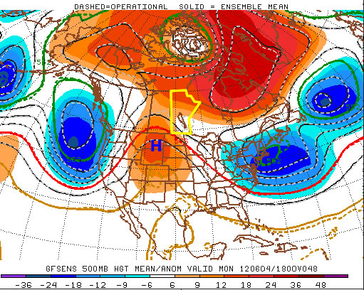
A southerly flow of air aloft, aided by a long-wave trough over the Rocky Mountains to our west and a blocking high to our east, will bring us our hottest days of the year through the rest of this week. Temperatures at 850mb are expected to rise to nearly 20°C today, which will result in daytime highs between 25-30°C through the second half of this week.

A weak low will move through Southern Manitoba on Thursaday night ahead of the main upper trough and while parameters don’t look too great for severe weather, a band of thunderstorms will likely develop in the late afternoon or early evening, intensify, and slowly move east-northeast. While tornadoes aren’t a likely threat with these storms on Thursday afternoon/night, CAPE values in the range of 1250-1750 J/kg combined with LIs near -5 and 20-30kt of bulk shear should provide enough for a threat of large hail. The slow-moving nature of the line of storms could potentially also produce a risk of locally heavy rainfall, with as much as 0.75-1.25” falling over a relatively short period of time. While showers will be commonplace over southwest Manitoba throughout the day on Thursday, the risk for showers does extend eastwards through the western and central Red River Valley in the afternoon. The bulk of precipitation will occur with the thunderstorms that develop in the evening, though.

This is still about 36 hours away, though, and things could change quite a bit between now and then. Models are having a hard time degrading the blocking pattern that’s in place right now, and some are much more progressive with features and some are much slower. If things end up more progressive than they look right now, there may be minimal storm threat for Thursday night.

Night 2 Thunderstorm Outlook

Thunderstorm Outlook for Night 2 (00Z to 18Z June 08).

Taking into account the various speeds, the current area that might see storms on Thursday afternoon/evening looks to be the area bounded from the US border north to Brandon, up towards Dauphin/Swan River, then eastwards across the Interlake and southwards down the eastern Red River Valley. Storms will exit through the Central/Northern Whiteshell. While the potential for heavy rainfall exists, I do not feel enough confidence in it to justify any slight risk categorization on the outlook. The storms will likely be marginally severe, though, so it’s important that they are not ignored with the prospect of even bigger storms on the weekend.

Friday looks to be another warm day; debris cloud left behind from Thursday night’s convection should clear bout by lunch time or early afternoon which will allow the sunshine to warm us up to the mid-to-high 20’s. Dewpoints will build through the afternoon pushing up to 18 or 19°C, making it feel quite humid. The main upper trough is set to move in on the weekend, though, and what a system it looks to be.

SPC Day 4-8 Outlook

SPC Day 4-8 Severe Thunderstorm Outlook

I’m not going to talk too much about Saturday’s setup yet, as it’s still a ways out and in this particular setup, the exact specifics are sure to change with every model run until it’s much closer. We’ll be under the influence of two strong shortwaves that will push copious amounts of instability over Southern Manitoba. CAPE values look to exceed 2500 J/kg and potentially be as high as 5000-5500 J/kg; this, combined with a weak cap north of the warm front and favorable shear profiles looks to point at a potent setup for severe thunderstorms with high probabilities of (extremely) large hail, strong winds, and elevated risks of tornadoes. The setup is similar to other tornado-producing setups of years past, including the Pipestone tornado of 2007.

We’ll have plenty of discussion about the upcoming storm threats in the comments, so be sure to check back often for the latest information about this weekend’s potentially dangerous storm outbreak.

Warm Start to June

After a warm weekend, which featured a beautifully Saturday and stormy Sunday, we will stick with warm to hot weather to start the week. A ridge of high pressure will gradually build into Southern Manitoba this week, allowing us to keep the warm conditions experienced on the weekend.

Upper ridge over Southern Manitoba

A ridge of high pressure is expected to build into Southern Manitoba this week

Monday will be a warm to hot day in Southern Manitoba, with high temperatures in the mid to high twenties under mainly sunny skies. Tuesday will again be warm and sunny day, with high temperatures in the low to mid twenties. An easterly flow pushing slightly cooler air into the province is the reason why Tuesday will be a bit cooler than Monday. Temperatures will climb again on Wednesday, as we reach back up into the high twenties under a south-easterly flow.

The weather through late week is, as usual, less certain. Thursday looks to remain warm but Friday into the weekend may be cooler. A low pressure system is currently forecast to cross Southern Manitoba on Friday, which will be a catalyst for cooler weather. More details will be available later in the week.

Trough over Western NA, Ridge over Central/Eastern NA

A trough will cause below-normal temperatures over Western North America (blue areas), while a ridge brings warmer weather to Central/Eastern North America (orange areas)

A quick update on the June forecast. Most long-range models are showing a ridge-trough pattern dominating North America through June. This pattern means a ridge will likely reside over Central/Eastern North America through a good part of June while a trough sits over Western North America. Southern Manitoba will be frequently caught in between these two features, causing our weather to be variable with hot spells as well as some cooler outbreaks. This pattern may also promote more chances for thunderstorms, though this is not as clear-cut.

At any rate, enjoy what will be a nice first half of the week!

Elsewhere in Weather News: June 2nd, 2012

Flooding Returns to China

Another round of flooding in China left locals in the province of Guangdong scrambling for higher grounds this past week as floodwaters rose and swept away homes. As opposed to the flooding in north-western China featured in the May 12th post, this flooding took place in the south-east regions about 200km north of Hong Kong and was associated with a low pressure system.

Flooding

Roads turn into rivers as heavy rains fall in Meizhou, Guangdong. (Source: Euro News)

The large city of Meizhou, Guangdong, was caught in the middle of one the most severe floods this year. Some 210,000 residents living in the city were affected and 25,500 had to be evacuated from terrain that is prone to landslides and flooding, prior to these heavy rainfalls. As torrential rains fell, landslides took out more than 1,000 houses and the extensive rains caused over 4,000 hectares of farmland to be lost. In addition to that, six people lost their lives in the floods. The government has estimated the financial tally to be over 30 million dollars, taking in consideration damaged crops and infrastructure as well as services used to fight against the floods.

This rain is the last thing China needs this year, as widespread flooding has been occurring throughout the country. Areas at risk have included the north-west earlier this May, the south-east this past week and coming week. Also, currently, in the central region of China, crews are already prepping dikes since rivers are expected to overflow their banks in the coming summer months. The latter threat is due to saturated grounds combined with forecast medium-range models suggesting one and a half times average rainfall – China’s Ministry of Water Resources are on high alert.

Forecast rainfall

Map showing more rainfall expected in Meizhou next Tuesday morning. (approximate location of Meizhou with red circle, rain in shades of grey). Rain was not only expected on Tuesday but also Monday and Wednesday. (Source: weather-forecast.com)

A Chance of Showers Today, Mild Weekend Ahead

A weak trough pushing across SW Manitoba today will push into the Red River Valley this evening, bringing with it some scattered showers or thundershowers. Things will clear out quickly, and we’ll be looking at temperatures in the mid-20’s for the weekend.

GEMREG QPF for Friday Afternoon

Total expected precipitation from teh GEMREG model this afternoon.

We’ll have a slightly more unsettled day today as a weak surface trough pushes into the Red River Valley this afternoon. Temperatures will climb up to just over the 20°C this afternoon before showers and thunderstorms develop over SW Manitoba and push eastwards into the Red River Valley. Dynamics begin to fall apart as the afternoon progresses, and any showers or thunderstorms will struggle to survive in an increasingly disorganized environment. It looks like the best chance of seeing some rain this afternoon will be through the Western Red River Valley, with diminishing chances east of the Red River. By the time the trough gets to the Whiteshell, the threat of precipitation will likely be over.

Saturday looks to be a gorgeous day as sunshine once again dominates across Southern Manitoba and highs climb to around 25°C. Things will turn a little more unsettled overnight on Saturday as an area of rain blossoms over Southern Saskatchewan and heads our way. The exact location of the rain is still uncertain, however best indications are that we’ll see a cloudy day across much of the Red River Valley, with the bulk of the rain passing north of Winnipeg through the interalke region, with only a chance of showers for Winnipeg and areas south. It will certainly be a system to keep an eye on as the weekend progresses.