Early Week Cool-Down, Yet Temperatures Remain Unseasonably Mild

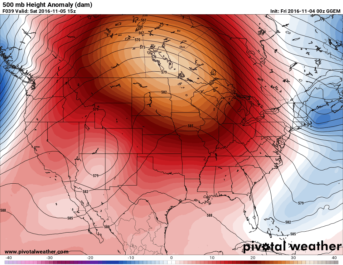
Gusty northwesterly winds will flush out the warm air mass that has brought record-setting warmth to the Prairies over the past few days, however the air that moves in behind is still quite warm and above-normal temperatures will continue through the week.

Record High Temperatures Set on Sunday

Several high temperature records were broken yesterday across Southern Manitoba:

New Record High Temperatures Set on November 6, 2016 in Manitoba (Based on weather summary issued by EC at 4:50PM November 6, 2016)
Location Temperature (°C) Old Record (°C)
Winnipeg 17.0 16.7 (1975)
Brandon 18.0 17.8 (2009)
Berens River 19.0 16.7 (1916)
Fisher Branch 14.6 14.0 (1981)
Gillam 9.5 7.8 (1975)
Gretna 14.3 13.6 (2010)
Island Lake 18.0 15.0 (1975)
Norway House 13.0 12.2 (1975)
Pinawa 17.9 17.8 (1975)
Sprague 18.1 17.8 (1975)
The Pas 15.0 14.4 (1975)

Additionally, with dewpoint temperatures climbing up to 12.2°C at the airport, Winnipeg officially had its most humid November day on record, beating out the old record of 11.6°C set on November 5, 1956.

The high dewpoint values were evident as moisture in the air spontaneously condensed onto cool pavement through the evening hours.

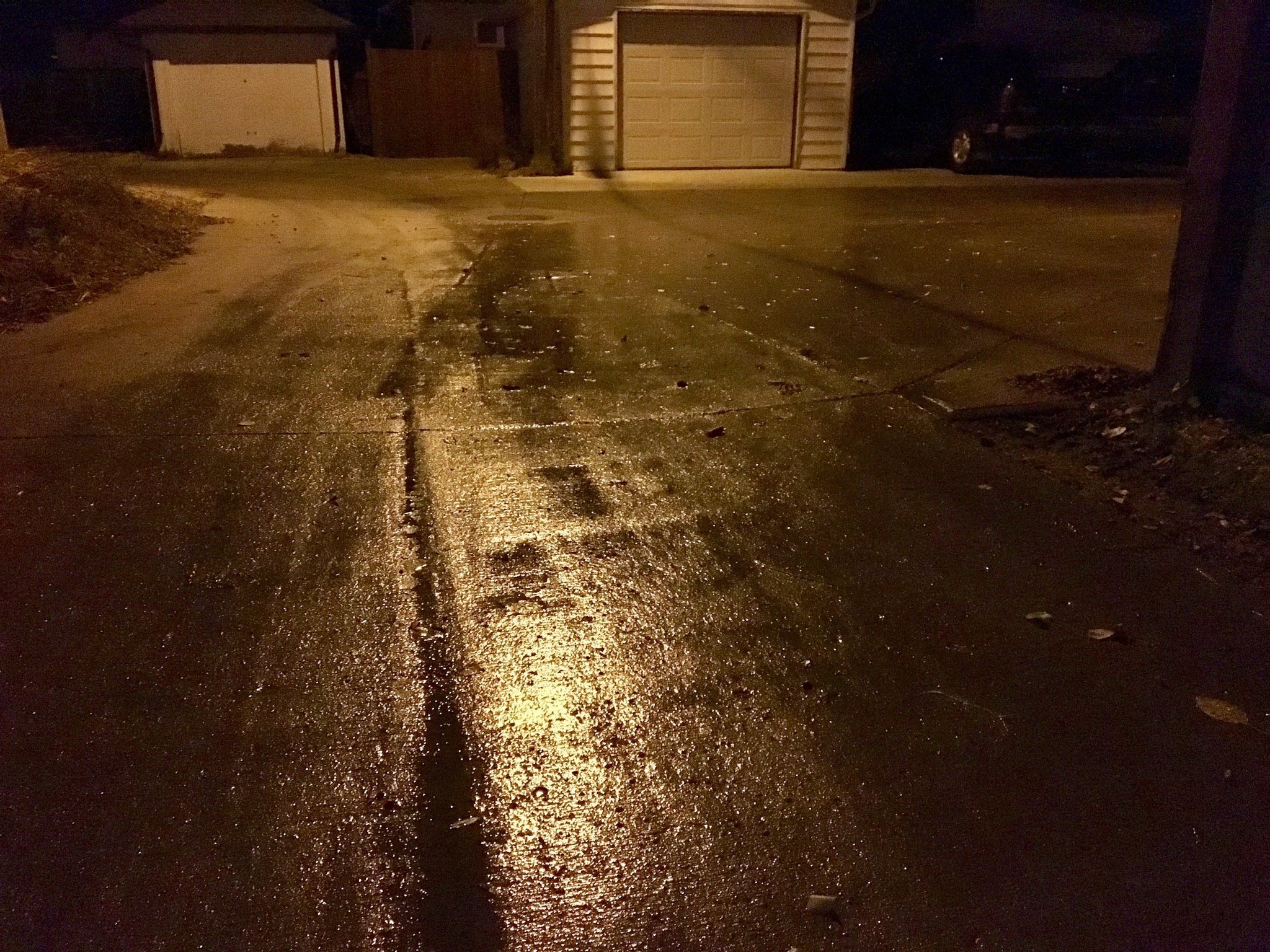
In fact, it was so humid that most roadways and sidewalks were wet as the humidity in the air condensed onto the cooler pavement, in some places making things so wet that it appeared like it had rained.

Cooler Start to the Week

Today will be a very windy day courtesy of a strong pressure gradient building into the region behind a low pressure system moving through early this morning. Winds will pick up this morning out of the northwest to about 40 km/h with gusts up in the 60-70 km/h range. Otherwise, we’ll see just a few clouds this morning before skies clear out, and then a bit of afternoon cloudiness returning. Temperatures will continue relatively mild, though, with a high near 11°C.

Skies should clear out overnight as temperatures dip to a low near 0°C with diminishing winds.

Tuesday will be a nicer day with a high once again near 11°C and light winds out of the south to southwest. Skies should be partly cloudy. Expect a low near 5°C on Tuesday night under mainly clear skies.

Wednesday will see warmer air once again return to the region. First, there’s a few suggestions that some fog patches may show up early in the morning, but if they were to develop, they would burn off quite quickly, so they wouldn’t be a concern outside of the early morning hours. After that, southerly winds of around 15-20 km/h will redevelop and help temperatures climb to a high near 14°C under fairly sunny conditions. Skies will remain mostly clear overnight as temperatures dip to a low near 7°C.

Long Range

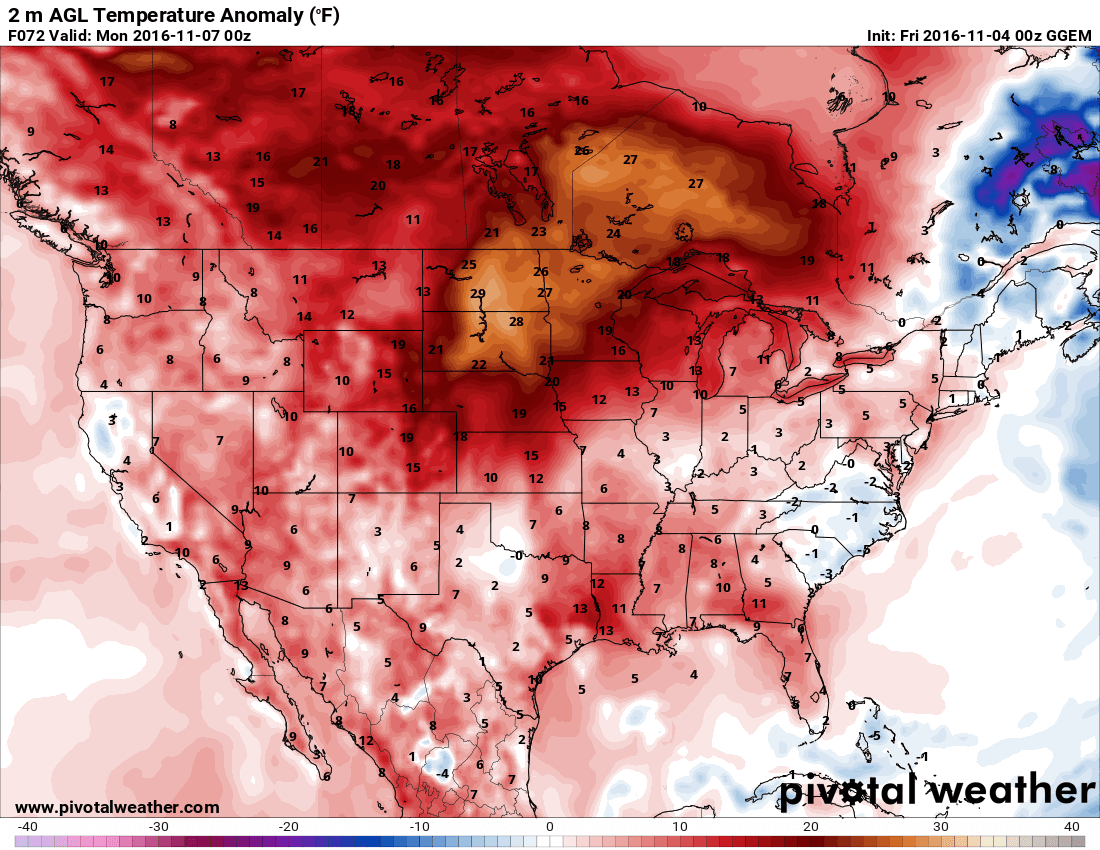
Above-seasonal temperatures continue through the remainder of the week, however the second half of the week is looking a little cooler with highs in the 5-10°C range and with some more cloud cover.

NAEFS 8-14 Day Temperature Anomaly Forecast — Valid November 14-21, 2016

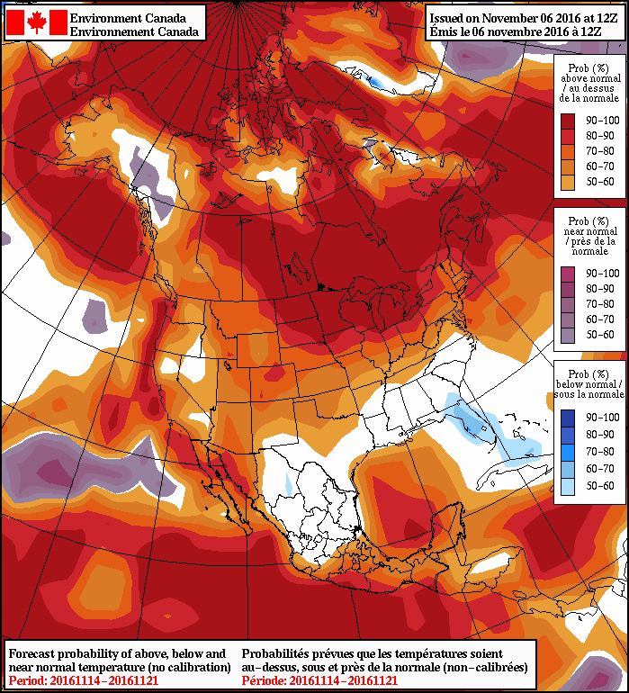
Looking even further down the road, it appears that the general pattern of above-seasonal temperatures will remain in place into the last third of the month with the NAEFS alongside other guidance suggesting high probabilities of above-normal temperatures. It also continues to look quite dry through this period as well. A beautiful November continues!

Winnipeg’s seasonal daytime high is currently 1°C while the seasonal overnight low is -7°C.

Warmer Weather Finally Arrives

The arrival of warmer weather was delayed due to an extensive fog bank that developed on Wednesday night and persisted through Thursday as fog, mist and overcast skies. Fortunately, that cloud has now been shunted eastwards by a warm front pushing eastwards across the Prairies and the warmer weather promised in our last blog post will arrive today.

Weather Setup

The main feature that will dominate the weather over the coming days is an upper-level ridge establishing itself over the Prairies.

This feature will draw highly unseasonal warmth across the entire Prairies and send temperatures over 10°C above normal for this time of year. Alongside the warmer weather, generally dry conditions will persist in areas where the upper-level ridge is established.

Forecast

Today will bring the first of the warmer days as westerly to southwesterly winds bring milder Pacific air eastwards into Southern Manitoba. Skies will be mixed as a weak disturbance brings some mid- to upper-level cloud to the region in the afternoon. Daytime highs in Winnipeg & the Red River Valley will top out around 13°C. Skies will remain fairly cloudy overnight as temperatures dip to a low near 4°C.

Saturday will be a very nice day with partly cloudy skies, light winds out of the south and temperatures climbing to around 15°C. Skies will remain fairly clear on Saturday night with temperatures dipping to near the 6°C mark.

Sunday will see increasing cloud in the afternoon as a disturbance moves up from the Dakotas into southern Manitoba, bringing with it a chance of showers overnight into Monday morning. It will be quite warm, though, with highs climbing up to around 16°C.

Long Range

After Sunday night’s disturbance, a southwesterly flow redevelops over the Prairies and the mild weather returns and persists until the weekend.

Winnipeg’s seasonal daytime high is currently 2°C while the seasonal overnight low is -6°C.

Extended Period of Unseasonal Warmth On The Way

A highly anomalous November weather pattern will set up through the remainder of the week, bringing an extended stretch of warm and dry weather to the Red River Valley.

Today will be the last cool, cloudy day for the next while, all thanks to a building 500mb ridge that will dominate the weather pattern for at least the next 5-7 days. Before that happens, though, we’ll need to power through a large deck of stratus cloud working across the Prairies. As a result, today will be fairly cloudy, perhaps a few sunny breaks here and there, with temperatures topping out at a slightly above-seasonal 6°C.

There’s a very slight chance of an afternoon/evening rain shower today as a weak impulse moves over the Red River Valley, but if it were to happen, it would be short-lived and not produce any measurable accumulation. Skies will clear overnight as temperatures drop to around 1°C.

Thursday will bring significantly nicer weather as a large upper-level ridge builds into the Prairies:

An upper-level ridge will build over the Prairies beginning Wednesday evening through Saturday.

This will bring more sun to the region as our mostly cloudy skies are replaced by partly cloudy skies both Thursday and Friday. Temperatures will also be well above seasonal with high temperatures in the 12-15°C range. While these are over 10°C above normal, they likely won’t be record-setting, as the record high temperatures are surprisingly warm for the beginning of November:

Record High Temperatures in Winnipeg for November 2-4
Date Record High Year Set
November 2 21.7°C 1903
November 3 18.8°C 2008
November 4 20.0°C 1975

Winds will be relatively light both Thursday and Friday at just 10-20 km/h.

Long Range

The long-range forecast is looking quite pleasant overall. Warm temperatures will continue to dominate the weather story throughout the first half of November as the upper-level ridging continues over the Prairies.

This forecast of 500mb heights for November 11th shows the highly anomalous heights over the Canadian Prairies.

There may be dips in the temperature here and there with the occasional passing disturbance, most likely back to slightly above-seasonal values, but the upper-level ridge will rebound and push milder air back into the region. Conditions should remain fairly dry through this period as well.

Winnipeg’s seasonal daytime high is currently 5°C while the seasonal overnight low is -5°C.

More Wet Weather on the Way

More rain is in store early this week as a well-developed low pressure system pushes across southern Manitoba. Accumulations will be relatively small in the Red River Valley, but more significant to the north and west.

A strong low pressure system will bring rain to southern Manitoba today

This Week

Rain will move into southern Manitoba today in association with a strong low pressure system coming out of Montana. Light rain will likely begin in the Red River Valley this morning, continuing into the afternoon. Models show a break in the rain during the evening hours, which might just provide a good window for trick-or-treating. Regardless of whether it’s raining or not, temperatures will be favourable for the youngsters to be outdoors, with temperatures hovering in the mid-single digits. Total rainfall of 2-5 mm is expected today, with another 2-5 mm tonight. Parts of western Manitoba and the Interlake can expect total accumulations ranging from 10 to 25 mm.

Today’s weather system will still be lingering over Manitoba on Tuesday, with some showers remaining possible through Tuesday morning. A drier flow should develop by Tuesday afternoon, signalling an end to the precipitation. Temperatures will remain relatively normal for late October, with high temperatures in the mid to upper single digits in southern Manitoba. Winds will be breezy out of the west at 20-30 km/h.

Nicer weather should arrive for Wednesday as a ridge of high pressure builds over the region. Mainly sunny skies and temperatures around or just below 10C are expected. Wednesday’s nice conditions should signal the beginning of a significant warm spell which should last into next week. Winds should be relatively light thanks to the surface ridge.

Long Range

Medium- to long-range models have been strongly hinting at a significant warm-up beginning mid to late this week. An anomalously strong upper ridge of high pressure is expected to build over Central North America, signalling a period of well-above seasonal conditions for Manitoba. Given that our normal high is 4C, we can easily expect temperatures of 10-15C. It is not impossible that we reach the upper teens once or twice when the “heat” peaks sometime over the weekend or next week. Models strongly suggest that this above-seasonal pattern will exist for most, if not all, of the first half of November.

An unusually strong upper-level ridge will build over Manitoba by next weekend