We’ll see more summer-like weather this week in Winnipeg and across the Red River Valley as it continues to feel more like July than the beginning of September.
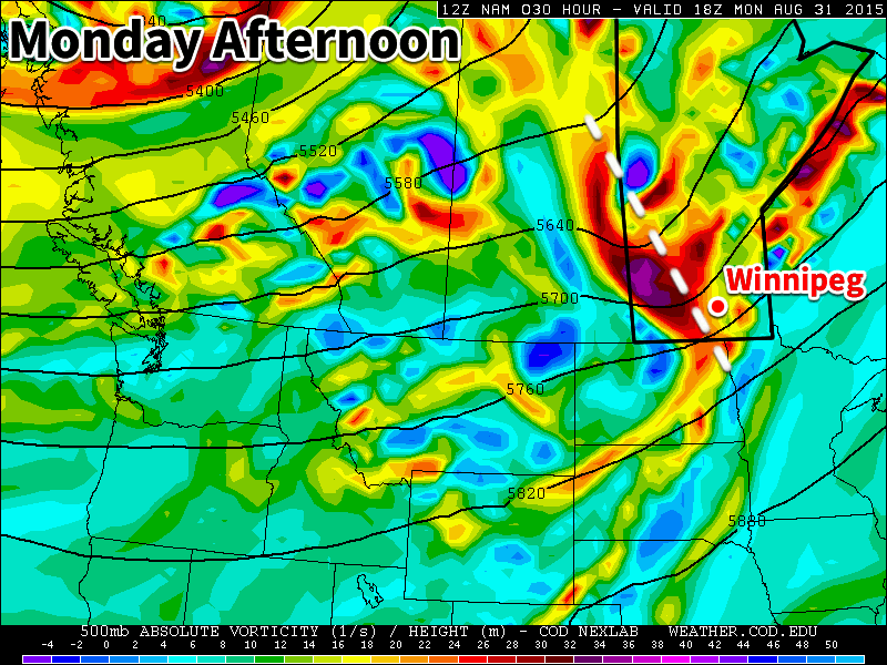
A shortwave trough (white dashed line) will pass through southern Manitoba on Monday, bringing clouds and a risk of thunderstorms.
Monday
Today will start out mainly cloudy as a potent upper disturbance moves through southern Manitoba. This disturbance may trigger some thunderstorms early on Monday morning, some of which could impact Winnipeg and the Red River Valley. Once the disturbance moves through, skies should clear, likely at some point in the afternoon. Temperatures will be in the mid to upper twenties with the wind becoming westerly due to the passage of this system.
Tuesday
Tuesday will be a nice day, as temperatures climb into the upper twenties under mainly sunny skies. Winds will be relatively light and from the south. No precipitation is expected on Tuesday, although some storms may develop overnight into Wednesday.
Wednesday
Like Monday, we may see some morning thunderstorms on Wednesday. A strong push of moisture from the south may help to trigger these storms. Should storms develop, they could be severe, but this forecast is still a few days away, so it could change. Besides the risk of storms, Wednesday will be hot and humid, with temperatures near 30C and breezy south winds.
Long Range
The long range forecast shows us cooling down after this week. Once a strong system passes through on Thursday temperatures will drop down to more seasonal values near 20C. Enjoy this little blast of heat while it lasts, it could be one of our last warm spells this year!
Notably warm and humid weather in place over Southern Manitoba today will bring a threat for severe thunderstorm activity across the region as a shortwave trundles through. An upper-level ridge will then begin to rebound back into the Southern Prairies in response to a digging trough off the western coast of North America, bringing even warmer air into the region thanks to the resultant southwesterly flow aloft that will develop.
Friday: Thunderstorms Possible Midday
A weak mid-level shortwave trundling across the region will bring a risk of thunderstorms to Winnipeg & the Red River Valley today[1] as warm and humid weather meets the colder air associated with the shortwave. As always, using our MIST principles:
Moisture: Adequate. Moderate moisture will be in place both at the surface and through the lower levels of the atmosphere as deep-layer moisture continues to build into the region.
Instability: Favourable. With both thunderstorm possibilities, both elevated and surface-based, enough instability will be in place. Surface-based convection would have greater potential to be severe, however it will rely on strong surface heating with mainly sunny skies until the shortwave arrives, which could be in question depending on what sort of nocturnal convection develops.[2] If it does end up cloudy, strong mid-level lapse rates associated with the shortwave should be enough to sustain showers or thunderstorms as it heads eastwards. All said, storms should have around 1000–2000J/kg of CAPE to work with, depending on their exact timing and where they’re based.
Shear looks quite good with around 35kt of 0–6km bulk shear and gently looping hodographs. Low-level winds are weak enough that tornado activity doesn’t look like a particular threat, but the directional shear is favourable for the organization of supercell thunderstorms.
Trigger: The shortwave moving through coupled with a weak surface trough will provide the convergence and trigger for convective initiation.
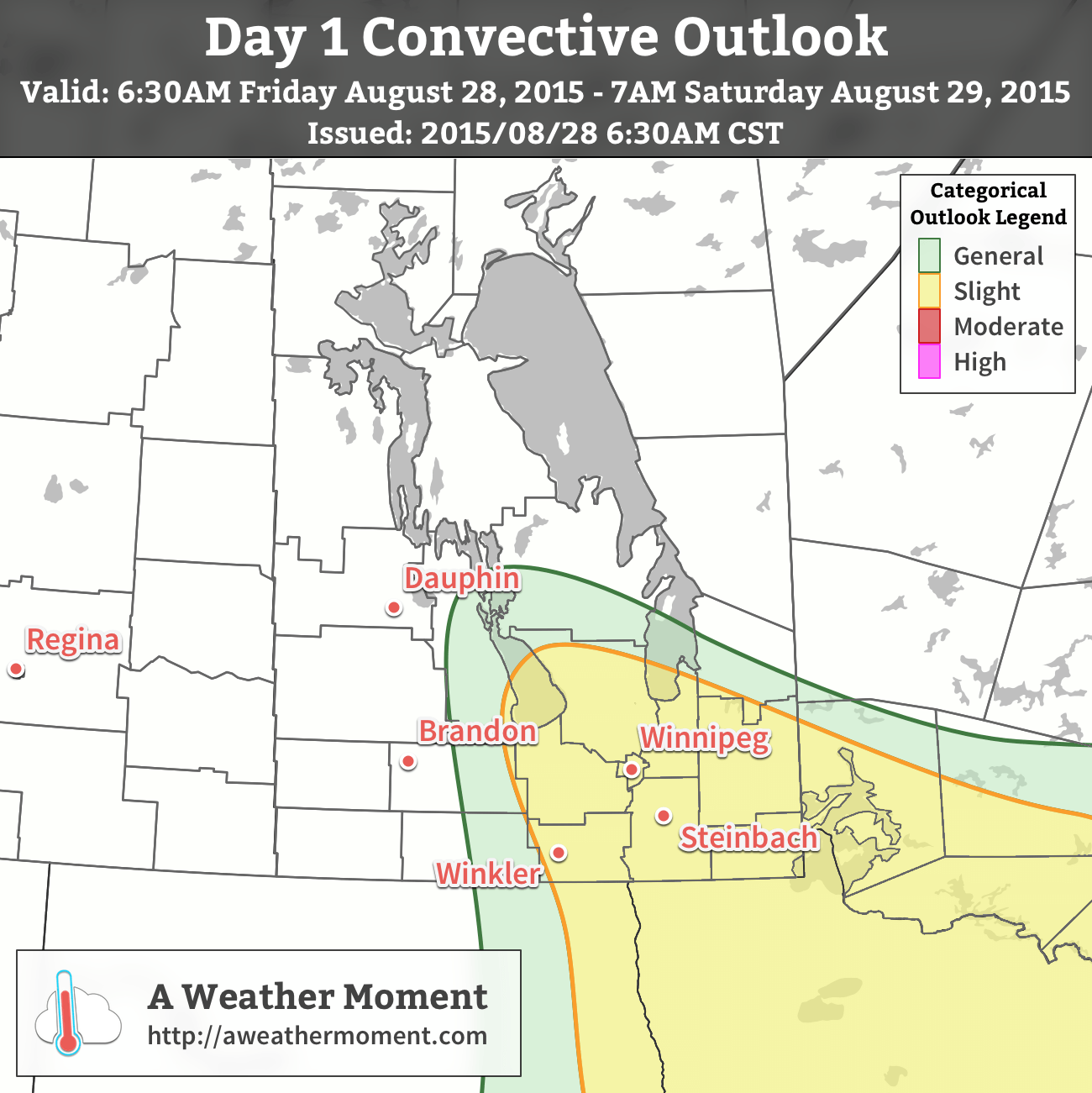
A slight risk of severe thunderstorms exists in the Red River Valley and southeastern Manitoba today.
All things considered, it’s likely that we’ll see some activity at some point today. The primary threats with today’s thunderstorms will be large hail and strong winds. Storm motions will generally be towards the southeast. Later in the day, a more organized heavy rainfall threat may develop with any storms still ongoing.
Those things aside, it will be quite a nice day. Temperatures will climb to around 28 or 29°C with a few clouds through the day. The humidity will begin to be more noticeable as dewpoints climb into the high teens by the afternoon ahead of the weak surface trough/low moving through. Winds will remain light.
Things clear out tonight with the humidity remaining in place and temperatures dipping down to about 17°C.
Hot & Humid Weekend Ahead
Temperatures will soar this weekend as warmer air moves into the region and sends daytime highs to 30°C or higher. Saturday will be a sunny day with a high around 30°C and dewpoint values in the high teens or low twenties making it feel more like the upper 30’s. Winds will be light. Expect a low near the 20°C mark on Saturday night.
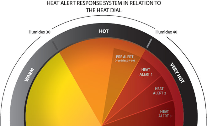
This weekend could see provincial (pictured above) or federal responses to the heat and humidity over the region.
Sunday will see the daytime high climb even higher, most likely towards the 32 or 33°C mark as breezy southerly winds develop ahead of a developing low pressure trough. The humidity will remain in place with dewpoints in the high teens or low 20’s, making it feel more like the upper 30’s. There’s a slight chance we may see humidex values hit 40 on Sunday, which is Environment Canada’s criteria for a heat warning. That said, both Saturday and Sunday will likely qualify for the Province of Manitoba’s Heat Advisory and Response Pre-Alert which requires a humidex of 37 or higher.
There appears to be a slight chance late Sunday night or early Monday morning for some showers or thunderstorms to move through the area, but it looks very conditional at this point and it’s far to early to say much about it. We’ll put an update here early Sunday afternoon regarding the precipitation potential for Sunday night. Temperatures will likely only drop to around 19°C on Sunday night, however.
Long Term: Slight Cool-Down to Start Next Week
Looking ahead, it seems like we’ll see a slight cool-down next week as a frontal boundary stalls out over the region and brings a chance for multiple bouts of unsettled weather through the first half of the week. We’ll have more details about that bright and early Monday morning!
Exactly when depends on the timing which will be affected by how much and what type of elevated convection developed with this feature overnight in Saskatchewan. ↩
If the nocturnal convection is in the right spot or strong enough, our sunshine could be replaced by cloud cover instead, dramatically limiting surface heating. ↩
Beautiful summer weather will be in place over the Red River Valley through the second half of this week with high temperatures in the mid-to-upper 20’s and just an ever so slight chance of an isolated pop-up thundershower.
The next few days will bring beautiful summer weather with daytime highs around the 25–27°C mark. These highs will be a few degrees above the seasonal values of around 23°C or so. Mild evenings are also ahead with overnight lows dipping just to around 14 or 15°C. Winds will also be quite light as a very weak pressure pattern establishes itself over Southern Manitoba.
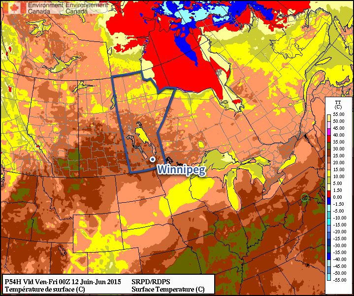
The RDPS shows temperatures in the mid–20’s over Southern Manitoba on Thursday afternoon.
Both today & tomorrow will see some pop-up cloud through the day thanks to daytime heating. Not much is expected from it, although there may be a few isolated showers this evening into the overnight period as a weak trough pushes through the region. Tomorrow will also bring a very slight chance of an isolated thundershower; by and large it will be a beautiful day with some afternoon cloud.
Friday looks wonderful with temperatures in the upper 20’s and mainly sunny skies and light winds.
A Look Ahead to the Weekend
The weekend is looking more unsettled than the second half of this week thanks to a large low pressure system slowly trundling through the Northern Prairies. Throughout Saturday and Sunday it looks like we may see a chance for some showers as a cold front stalls out over western Manitoba and multiple disturbances ripple northeastwards ahead of it. Temperatures will remain in the low-to-mid 20’s, depending on exactly how much cloud cover we see.
Not a terrible weekend, and hardly a washout; just be aware that there may be some wet weather on and off, depending on where exactly you find yourself!
The heat is on the way to Southern Manitoba as warmer air finally spills eastwards bringing positively summer-like weather to the area.
There is astonishingly little to say about the coming few days. Temperatures will climb into the mid–20’s Friday, Saturday and Sunday with overnight lows near 11 or 12°C all 3 days. Winds will be fairly light with the slight possibility of some breezier conditions on Saturday afternoon, but even there it would only likely be 20–30km/h. No precipitation is expected, although there will be a slight chance of some showers on Saturday north of Winnipeg along a very weak cold front from Dauphin eastwards across the Interlake.
All in all it will be a perfect weekend to get outside either here in the city or head up to the cottage for a truncated mulligan of the May long weekend!
Uncertain Start to Next Week
The beginning of next week presents another interesting forecast challenge as yet another Colorado Low forms and pushes northwards into the Dakotas. Model forecasts currently diverge quite a bit, demonstrated easily by the current forecasted storm-total precipitation for Winnipeg produced by each one:
Forecast Storm-Total Precipitation for Monday’s Colorado Low
Model
Storm-Total Rainfall (mm)
GDPS
16
NAEFS
8
GFS
0
In general, amounts increase to the south and east of Winnipeg in all the forecast scenarios. Why the big difference? The track of the Colorado Low will depend significantly on how it interacts with thunderstorm activity that develops through the Central Plains as it ejects northeastwards from Colorado. If the convection forms close to the upper-level low and has a significant amount of moisture wrap into it, it will strengthen more, tilting the entire upper-level trough and pulling the system further northwest. If the moisture from the convection pulls off to the east over the upper-level ridge, then the system will be a bit faster, weaker and further southeast.
At this point, there’s still far too much disagreement in the models to make much of a forecast. Overall, the GDPS – currently forecasting the highest amounts for Winnipeg & the RRV – tends to produce too much convection and over-develop lows. They’ve made significant improvements in the latest version of the GDPS, but it still tends to have that strong bias which results in slower systems further to the NW. I think the GFS solution of nothing at all to likely be missing the mark and not quite worth banking on.
That leaves us with the middle-of-the-road answer. Likely some rain on Monday, however not likely as much as advertised by some weather sources right now. We’ll certainly keep an eye on things as they develop and have some updates later in the weekend on how it looks like things are developing.
But for now, get out there and enjoy the hot & dry weather!