October Starts By Heading into Chilly Weather

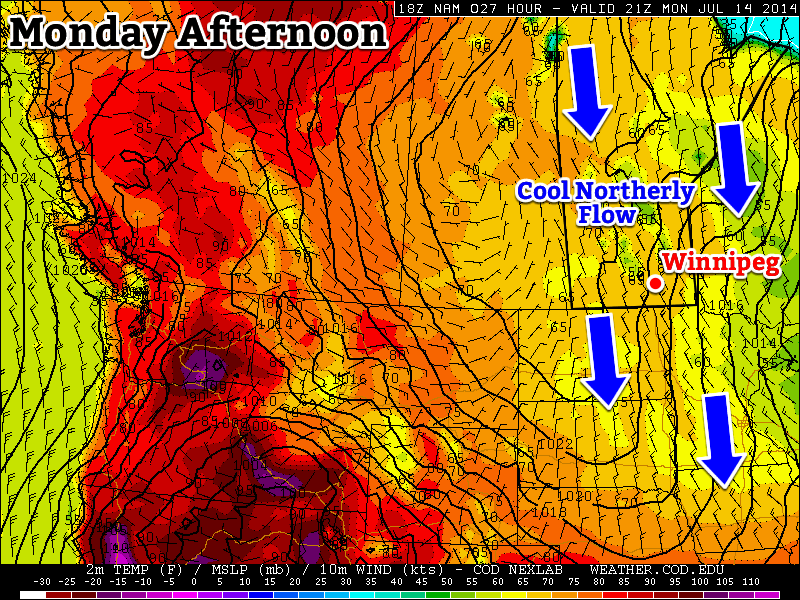
Temperatures will be on the slide as a low pressure system bringing unsettled weather today draws in cooler air behind it, plunging southern Manitoba into yet another spell of unseasonably cool weather.

Wednesday
17°C / 10°C
Cloudy with a few showers

Thursday
16°C / 5°C
Mainly sunny, showers likely in the evening

Friday
10°C / 1°C
A few sunny breaks, otherwise mainly cloudy with light showers

Wednesday

Today will be a mainly cloudy day here in Winnipeg with rather pleasant temperatures – highs will be around 16 or 17°C – alongside a brisk southerly wind to 30–40km/h. The warmer temperatures are thanks to a strongly wound-up low pressure system lifting northwards near the Manitoba-Saskatchewan border. It will spread an area of rain through Manitoba, but the bulk of it should be isolated along the main deformation axis of the system, sliding northwards through SW Manitoba and Parkland Manitoba into the northern half of the province. Scattered showers will likely be seen through the Red River Valley, but it doesn’t seem like much organized precipitation will develop; as such, rainfall amounts should remain fairly low over the region.

Total precipitation forecast by the RDPS from 7AM to 7PM today.

Skies will remain mostly cloudy this evening with a chance for some shower activity continuing until around the middle of the night. Clearing will begin afterwards as we head to a low of around 5°C.

Thursday

Thursday will actually be quite a pleasant day; most of the cloud cover should be off to our east leaving us with quite a bit of sunshine through the day as we head to a high once again around 16°C. By late afternoon, though, skies should begin to cloud up in advance of a potent shortwave barreling down in the northwesterly flow behind today’s system. Showers will develop under the shortwave as it progresses southeastwards with much of the Red River Valley seeing some amount of rainfall before 9PM or so. There is a slight chance of seeing some lightning or small hail in some of the shower activity if it manages to develop intensely enough.

A simulated RADAR image from the NAM depicting the potent shortwave moving through on Thursday.

A brief reprieve will be in store for the middle of the night, but more shower activity is expected to move through later overnight into Friday morning on the back-side of the shortwave. The temperature will dip to around 5°C.
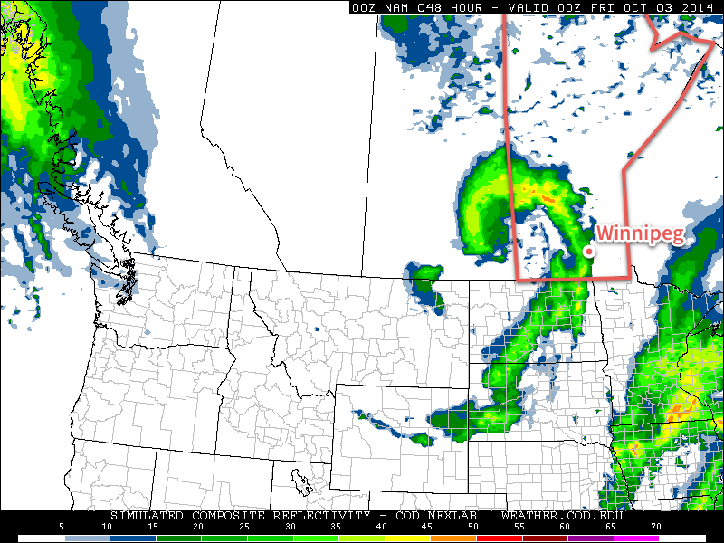
Friday

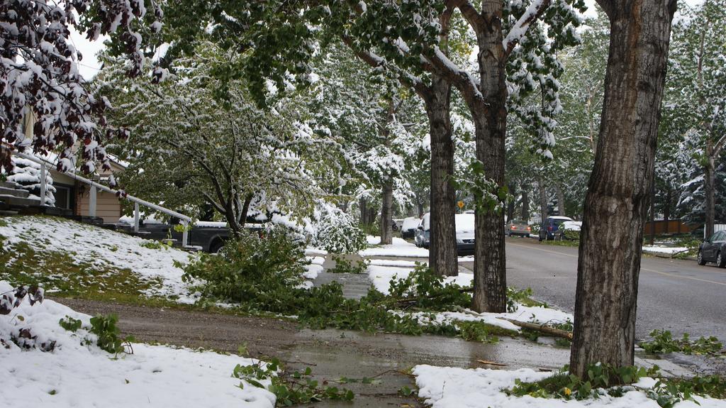
Friday will start off cloudy with a few remnant showers from the shortwave pulling off to the east. The shower activity should move off relatively quickly, but there’s a slight chance things will linger a little longer if the shortwave stalls out over SE Manitoba. Afterwards we’ll be entrenched in a northwesterly flow with Arctic air spilling southwards into the province. Our temperature will top out around 10°C with some lake-effect drizzle/showers likely in the lee of the lakes.[1]

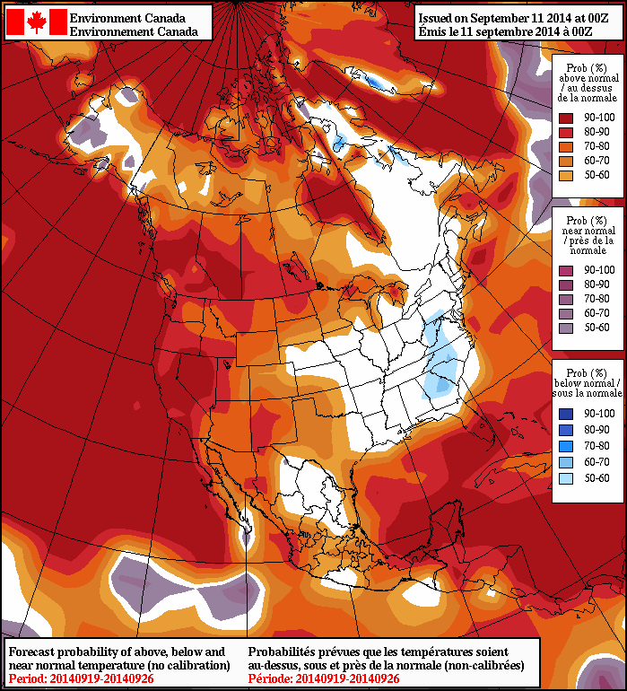
The Arctic air mass moving in will be the coldest air mass of the season so far in Southern Manitoba. Temperatures will drop to 0–2°C on Friday night under mainly clear skies and a brisk northwesterly wind. Some areas will see cloud streaming off of the lakes, again though where that cloud goes will depend exactly on which way the wind blows.

Cool Weekend Ahead

This weekend will be a cool one as cold Arctic air entrenches itself over the province. Daytime highs will sit in the low teens with overnight lows in the low single digits, perhaps even dipping just below 0°C. Sunday may bring the chance for some shower activity pushing in from the east, but things look rather uncertain at this point.


  1. The wind direction makes it look unlikely that the lake-effect activity will push into Winnipeg; keep in mind that which areas see lake-effect precipitation is extremely sensitive to wind direction.  ↩

Cool Weekend, Warming Next Week

Cool weather will persist across Southern Manitoba this weekend as the region remains under the influence of an unseasonably cold outbreak of Arctic air. Temperatures will continue to slowly moderate, however things will be generally mixed through the weekend with a fair amount of cloud and slight chance of precipitation. The real warm-up will build into the region next week, returning us to summer-like weather.

Friday
13°C / 4°C
Mainly sunny

Saturday
14°C / 5°C
Mainly cloudy

Sunday
14°C / 5°C
Mixed skies

Today will be the nicest day that the area has seen in a while thanks to a westerly wind which will help dry out the low-levels and clear out the cloud that has been so persistent over the past week. Thanks to that, mainly sunny skies will be seen in Winnipeg and throughout much of the Red River Valley with westerly to southwesterly winds up to around 20km/h. Temperatures will remain cool, however, as the wind will be outflow from the colder air mass slumping to our south; highs through the Red River Valley will sit near the 13°C mark.

Tonight will see mainly clear skies with a little bit of cloud working in from the northwest late in the overnight period and a low near 4°C.

Cool, Mixed Weekend

Saturday will be a mainly cloudy day as a weak trough of low pressure swings through the Red River Valley. While no precipitation looks likely, there will be a slight chance of some isolated, light shower activity. The temperature will climb to around 14°C for a high temperature in the valley.

Skies will begin to clear overnight as the trough slides off into Ontario and winds back to northwesterly, although another slightly cool shot of air will be moving in behind the trough so some cloud with a chance of showers or drizzle in the lee of the lakes is likely. Lows will be near 4 or 5°C in Winnipeg & through the Red River Valley.

Sunday will bring mixed skies with a chance of drizzle or showers in the lee of the lakes. The high will once again be near 14 or 15°C while the overnight low drops to a repeat 5°C.

Warmer Weather Next Week

The NAEFS is forecasting above-normal temperatures across Southern Manitoba in the 8-14 day outlook.
The NAEFS is forecasting above-normal temperatures across Southern Manitoba in the 8–14 day outlook.

Manitobans will be repaid for their patience with the cold weather – if medium-to-long-range enesemble models are to be believed – with a hurried return to summer-like conditions. Both Canadian and American models show an upper-level ridge building eastwards across the Prairies next week brining significantly warmer air with it.

850mb temperatures will climb early next week from the –2°C or so they sit at this morning over Winnipeg to around 10°C. This warming aloft will translate to significantly warmer temperatures down here where we live, with daytime highs moving from low-to-mid teens up to the low 20’s.

The weather also looks fairly dry through the warm-up, although by week’s end there looks to be a chance of showers or thunderstorms as a low pressure complex tracks eastwards through the Prairies & Northern Plains of the United States.

Coldest Weather of the Week Still Ahead

Unfortunately, this week’s plunge into terrible cold for September is far from over, with cooler temperatures still set to work their way into Southern Manitoba. The growing season will be at risk for a tragically early end with frost a slight possibility over the next couple nights here in the Red River Valley.

Calgary, AB and its surrounding areas have been hit particularly hard by this early-Fall oubreak of cold weather, with up to 25cm of snow causing all sorts of problems, including broken tree branches as shown in this picture taken in NW Calgary. Credit: @jpaint (Twitter)
Calgary, AB and its surrounding areas have been hit particularly hard by this early-Fall outbreak of cold weather, with up to 25cm of snow causing all sorts of problems, including broken tree branches as shown in this picture taken in NW Calgary. Credit: @jpaint

The weather story for the Red River Valley over the next few days is dominated by a rather significant high pressure system slumping southwards through Alberta. The 1034mb or stronger high is a result of a large outbreak of cold air from the high Arctic and while the high center is sliding down the foothills of Alberta, the system covers the entire Prairies.

This means that substantially below-normal temperatures[1] accompanied by brisk northerly winds will persist for much of the rest of the week before slightly milder air finally pushes across the Prairies as the high pushes southwards into the United States.

Wednesday
12°C / 2°C
Mixed skies; drizzle possible overnight.

Thursday
12°C / 1°C
Mixed skies

Friday
13°C / 5°C
A few clouds

Today will be a windy day with moderate northerly winds to around 30km/h and a high of only 12°C or so. Skies will be fairly mixed, although it will become more consistently cloudy this evening as cooler air begins working into Southern Manitoba aloft and the lakes begin producing more cloud. By late-evening a slight chance of drizzle will work its way into Winnipeg as north/northeasterly winds bring in cloud streamers off the south basin of Lake Winnipeg. Drizzle or showery weather is more likely near the Portage La Prairie region where Lake Manitoba, under slightly colder air and more favourable wind profiles undergoes more vigorous lake-effect activity.

Temperatures will drop to around 2°C or so, however it’s possible that the temperature drops to the freezing mark with some frost in some of the rural areas in the Red River Valley, depending on where cloud vs. clear skies set up.

Thursday will bring mixed skies again, although the winds should be a bit lighter than today. The high will once again be around 12°C. There will be more cloud from the lakes on Thursday night and a slight chance for some drizzle down-wind of the lakes as we head to a low of around 1°C. Once again, it’s possible some areas see the temperature drop to the freezing mark in rural regions, depending on cloud cover.

Friday will bring a shift in the weather as the high finally slumps to our south and westerly winds work their way in. We won’t see the temperature move much during the day thanks to the fact that, despite the shift in wind, southern Manitoba will still be under the influence of outflow winds from the high. The westerly winds should clear things out, allowing for our sunniest day of the week.

A disturbance will then begin diving southwards from the Northern Prairies on Friday night, spreading cloud ahead of it and slightly milder temperatures aloft. As a result, temperatures will likely be a little warmer on Friday night with lows near 5°C.

Improving Conditions for Next Week

Looking ahead, things look to begin gradually improving on the weekend. Saturday will bring some sun and cloud alongside a slight chance for some shower activity as a weak disturbance trundles through. On the backside of the system lake-effect showers/drizzle will again be possible on Saturday night. Temperatures will likely be limited to the low teens on Saturday.

Sunday will be a nicer day. At this point it looks like it will likely be a mainly sunny day with a high in the mid-teens. There’s some discrepancy in models right now with some models suggesting a mainly cloudy day, others mainly sunny. We’ll have to wait and see what exactly pans out for the day.

The NAEFS 8-14 day temperature anomaly forecast is calling for above-normal temperatures in Southern Manitoba.
The NAEFS 8–14 day temperature anomaly forecast is calling for above-normal temperatures in Southern Manitoba.

Into next week, it looks like we’ll see a return to summer weather as a surge of warm air spills eastwards across the Prairies. The NAEFS[2] is calling for above-normal temperatures in the 8–14 day outlook, which will be a welcome relief after this very early cold snap. Models are suggesting that next week will be relatively dry, with the potential for rainfall near the end of the week.


  1. Normal temperatures for around August 10th in Winnipeg are highs of 19°C and lows of 7°C.  ↩
  2. North American Ensemble Forecast System  ↩

A Slow Recovery

After a major temperature setback on the weekend, we’ll see summer gradually return this week.

A northerly flow will maintain cool conditions over Manitoba to start the week

Monday

Monday
20°C / 8°C
Mix of Sun and Cloud. Chance of Showers.

Today will be cool, with temperatures remaining well below normal values. High temperatures will be in the upper teens or lower twenties, with a breezy north-west wind. We may also see some light shower activity during the day as pop-up showers develop with daytime heating.

Tuesday

Tuesday
21°C / 9°C
Mix of Sun and Cloud

Tuesday will be a pleasant day, but it will still be on the cool side. Temperatures will be in the low twenties and winds will be relatively light. Some convective cloud cover will develop by the afternoon, and perhaps a stray shower here and there as well, but it won’t amount to anything of significance.

Wednesday

Wednesday
24°C / 11°C
Mainly Sunny

Wednesday will see temperatures recover further, with values in the low to mid twenties. Cloud cover should be less than earlier in the week and winds will remain light.

Long Range

The long range forecast is looking more summer like. Some models suggest we’ll see temperatures climb into the thirties either late this week or on the weekend. As temperatures begin to climb, the humidity likely will as well. That additional humidity means that the thunderstorm risk will begin to increase again. It’s too early to say if we’re looking at more severe storms, but that potential is usually present under humid conditions.