Warm Weather Ahead

Winnipeg will see daytime highs climb above freezing right through the weekend.

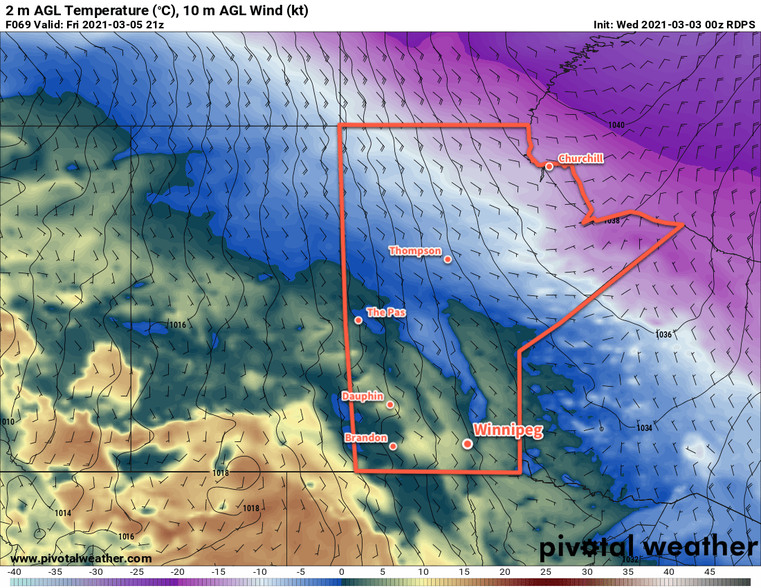
A broad upper ridge of the Prairies will bring plenty of sunshine and warmth to Winnipeg over the coming days. Both Friday and Saturday will bring plenty of sun to the city along with highs near 6 °C. The winds will stay light today, but a low pressure system moving from Saskatchewan into northern Manitoba will bring southerly winds of 40 gusting 60 km/h to the Red River Valley on Saturday. Lows will dip to around -6 °C tonight and just below freezing on Saturday night.

GDPS 2m Temperature Forecast valid 00Z Monday March 8, 2021
Mild temperatures will spread across the Red River Valley on Sunday.

On Sunday, Winnipeg will see mostly cloudy skies as a low and associated trough moves through the province. No notable precipitation will fall over southern Manitoba, but skies should stay mostly cloudy through the day. It will be warm with a high near 8 or 9 °C, but will be a few degrees warmer than that over the western Red River Valley. Winnipeg may climb over that high if the westerly winds arrive earlier in the day or a bit more sunshine materializes. Winds will ease midday into the 20–30 km/h range, then shift westerly as the trough passes.

Winds will ease Sunday night with lows near -2 °C and partly cloudy skies.

Long Range Outlook

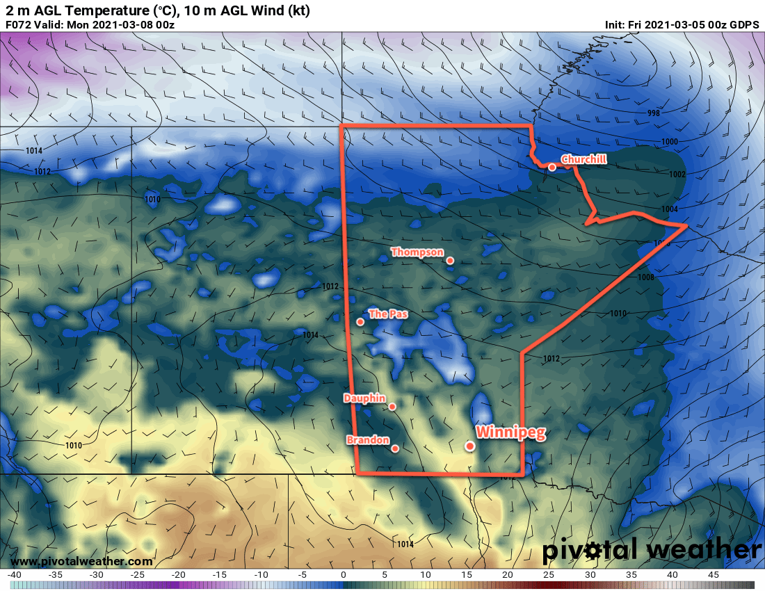
Conditions will turn a little more unsettled next week as low pressure system moves out of the Northern Plains into the region. Winnipeg may see some rain or snow on Tuesday, followed by some sun and slightly cooler — but still seasonably mild — temperatures.

Today’s seasonal daytime high in Winnipeg is -4 °C while the seasonal overnight low is -14 °C.

Mild Weather Ahead

Winnipeg will continue to see seasonably mild conditions right through the coming weekend.

A broad upper ridge building across the Prairies will bring mild weather to southern Manitoba over the coming days. Winnipeg will see light east-southeast winds with highs gradually climbing from around -1 °C today up to +3 °C on Friday. Overnight lows will also be mild, coldest tonight near -8 °C and warming to -2 °C by Friday night.

RDPS 2m Temperature Forecast valid 21Z Friday March 3, 2021
Very mild temperatures will begin to push across the southern Prairies by Friday.

Skies will stay mostly sunny over the next couple days with just a few clouds around both today and tomorrow. A sharpening warm front moving into the region on Friday will bring a bit more cloud, but no notable rain or snow will fall over the coming days.

Long Range Outlook

This weekend, a low pressure system will move from southern Alberta northeast into northern Manitoba, bringing a surge of warmer weather with it. With breezy southerly winds, temperatures will climb into the upper single digits this weekend across southern Manitoba. The precipitation with this system should stay well to the west and north.

Behind this low, cooler conditions will return to the region next week. Unsettled conditions with a chance of rain and/or snow are possible by next Tuesday and Wednesday as winds shift to the north.

Today’s seasonal daytime high in Winnipeg is -5 °C while the seasonal overnight low is -15 °C.

Spring-Like Warmth Arrives

Many in Winnipeg will remember February for the brutal cold that began the month. March will start on a very different note as spring-like warmth arrives!

After a rather cold night where lows in Winnipeg bottomed out in the low minus 20s, temperatures will climb through the next 36 hours. A Pacific low crossing the central Prairies will push a warm front eastwards, first through Alberta and Saskatchewan today, then Manitoba tonight. In Winnipeg, winds ahead of the front will pick up out of the south to 40 gusting 60 km/h for the afternoon and evening.

Temperatures will climb to a high near -12 °C today, although that wind chill will make it feel rather unpleasant. A sunny start to the day will turn cloudier for the afternoon/evening cloud ahead of the front. There will be a slight chance for some flurries, but the dry southerly ridge outflow winds will likely keep things mostly dry through a majority of the Red River Valley.

Skies will stay mixed to cloudy tonight with winds easing to 30 gusting 50 km/h for most of the night. The warm front will push through overnight, bringing temperatures up to around -2 °C by Tuesday morning.

RDPS 2m Temperature Forecast valid 21Z Tuesday March 2, 2021
Mild, spring-like warmth will move across much of southern Manitoba on Tuesday.

On Tuesday, Winnipeg will see temperatures climb above 0 °C to a high near +4 °C, although warmer highs of 5–10 °C will materialize over the western Red River Valley. Winds will ease in the morning, then gradually veer to the northwest for the afternoon as they strengthen back to 30 gusting 50 km/h. The city will see partly cloudy skies through the day. Winds will drop off quickly on Tuesday evening with skies clearing and temperatures heading to a low near -11 °C.

Mixed to cloudy skies will move in for Wednesday with a light southeast wind. Temperatures will climb back up to a high near the freezing mark. Temperatures will dip to a low near -12 °C on Wednesday night.

Long Range Outlook

More warm air is on the way through the second half of the week as an upper ridge builds across the Prairies. Highs will climb above freezing — perhaps even into the upper single digits — through the second half of the week and into the weekend. The upper ridge should keep any precipitation at bay until next week, where some snow may be possible as the ridge moves off to the east.

Today’s seasonal daytime high in Winnipeg is -5 °C while the seasonal overnight low is -15 °C.

Warmth Finally Arrives in the Red River Valley

A long-awaited warm-up will finally arrive in the Red River Valley this weekend!

A series of Pacific lows crossing western Canada will shunt Arctic air eastwards and push milder temperatures across the Prairies over the next few days. The first is beginning its eastward trek across the southern Northwest Territories today. While that will mean warmer weather for the western Prairies, southern Manitoba will stay under the influence of a weak Arctic ridge. It will keep highs to around -13 °C in Winnipeg with sunny skies and light southerly winds.

Temperatures in Winnipeg will dip to a low near -18 °C tonight with a few clouds moving in. Southerly winds will increase into the 20–30 km/h range by Saturday morning.

On Saturday, the Arctic low will push from Nunavut into Hudson Bay and drag a warm front eastwards across Manitoba. Brisk southerly winds of 30–40 km/h will persist Saturday morning and then gradually ease in the afternoon. Skies will cloud over as the warm front moves in and while some flurries are possible, the dry southerly wind should keep the snow out of the Red River Valley. Temperatures will climb to a high near -7 °C in Winnipeg.

The city will see mixed skies on Saturday night with a low near -9 °C. The wind will keep up out of the south at 15–25 km/h.

2m Temperature Forecast valid 21Z Sunday February 21, 2021
A push of milder Pacific air will reach southern Manitoba on Sunday.

On Sunday, another Pacific low will begin to push eastwards across the Prairies. It will push warmer air eastwards across the Prairies and bring widespread above-freezing temperatures to parts of Alberta and Saskatchewan. Here in Manitoba, temperatures should climb to around the freezing mark with southerly winds of 20–30 km/h. The city should see plenty of sun, giving a chance that some areas with darker surfaces (less snow, more concrete) might climb above the 0 °C mark.

The winds will keep up on Sunday night with increasing cloud. Temperatures will fall to a low near -7 °C early then gradually climb through the night.

Long Range Outlook

The Pacific low will cross Manitoba on Monday, bringing a wave of mild Pacific air with it. Temperatures will climb above freezing across much of southern Manitoba with brisk westerly winds and mixed skies. The mild weather will continue on Tuesday with temperatures returning to around freezing. The rest of the week will be a bit of a temperature roller coaster, alternating between near-seasonal and below seasonal warmth.

There will also be several chances for a wintery mix of precipitation as a series of impulses slide southeastwards across the Prairies.

Today’s seasonal daytime high in Winnipeg is -7 °C while the seasonal overnight low is -17 °C.