Sun Breaks Through For A Mild Weekend

Winnipeg will see a reprieve from the damp, cloudy weather this weekend as the clouds clear out later today and clear to mixed skies move in. Alongside the sun, daytime highs over 5°C above normal will remain in place, continuing the likely record-setting above normal temperature trend seen for the entirety of November so far.

Today will start off cloudy, however throughout the afternoon the clouds should begin to break up as some drier air moves in from the southwest. Without the persistent fog and mist in place, temperatures will have a bit more mobility than they have the past couple days, and Winnipeg should see a daytime high near 3°C. Winds should remain fairly light through the day out of the south to southwest. Expect clear skies giving way to a bit of cloud on Friday night, with temperatures dipping to a low near -3°C.

Saturday morning will start off with some cloud in the area as a warm front pushes through, but then we should see clearing and some sunshine for the afternoon.1 Temperatures should climb to a high near 3°C again with light winds out of the south to southeast. Skies should remain fairly clear on Saturday night with a low near -3°C again.

Sunday will bring increasing cloud to the city through the day as a significant weather system begins organizing south of the border. While skies will be mixed, temperatures will still be pleasant with highs yet again near 3°C. Winds will be out of the southeast at 10-20 km/h. Cloud cover will increase on Sunday night with temperatures dipping down to around 0°C.

Record Warmth

So far this month, Winnipeg has had an average high temperature of 8.1°C. With the forecast temperatures ahead, November will end with an average high temperature near 7.1°C and a mean temperature2 of approximately 2.6°C. The average high temperature will likely end up taking the or spot for warmest Novembers by average high temperature.

RankAverage
Daily High (°C)
Average
Daily Mean (°C)
Average
Daily Low (°C)
17.2 (2016)3.1 (2016)-1.1 (2016)
27.1 (2009)1.3 (1899)-3.2 (1923)
36.4 (1999)1.3 (1923)-3.3 (1899)
45.8 (1899)1.0 (1981)-3.3 (1922)
55.8 (1923)0.9 (2001)-3.5 (1981)
65.7 (2001)0.8 (2009)-3.6 (1917)
75.5 (1981)0.6 (1999)-3.7 (1953)
85.3 (1939)0.5 (1917)-3.9 (2001)
95.2 (1904)0.2 (1922)-4.3 (1918)
104.6 (1917)0.1 (1953)-4.3 (1944)

So far November has had an average overnight low of -0.8°C, with a forecast month-average of -1.0°C. This is a whopping 2.2°C above the previous record of -3.2°C set in 1923. The monthly mean temperature is forecast to end up at about 2.6°C, which crushes the previous record by 1.3°C. To put that in perspective, Winnipeg is forecast to break the previous monthly mean temperature record by the same amount as the spread from the current record to the 10th place entry.

Long Range

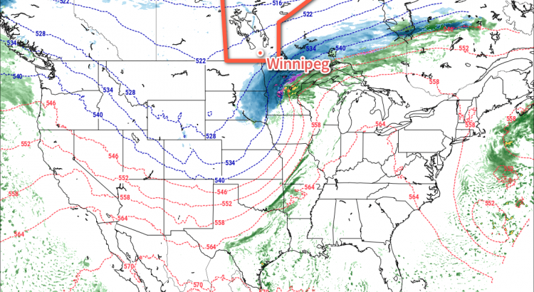
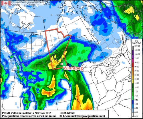
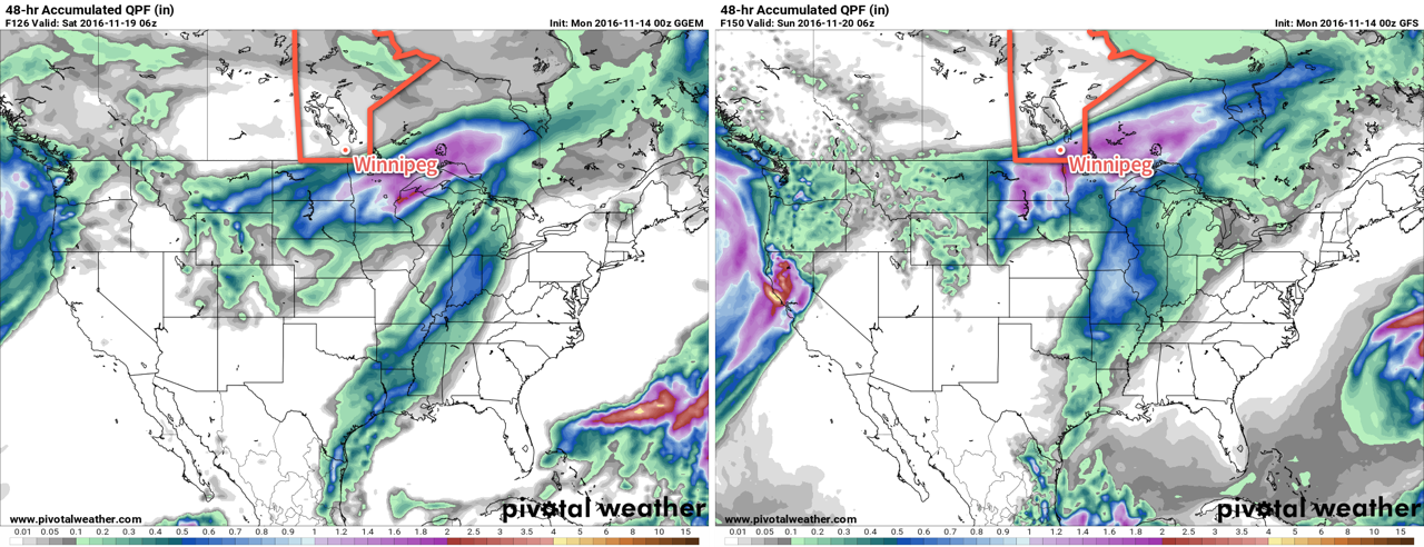
The start of next week threatens another winter storm for the region as a Colorado Low moves into Minnesota. Again there’s quite a bit of uncertainty as to how progressive the system will be and whether it will back into the Red River Valley or end up further east and missing the province. The general agreement is that the Red River Valley will be hit by this system, but how much precipitation will fall is a wild card.

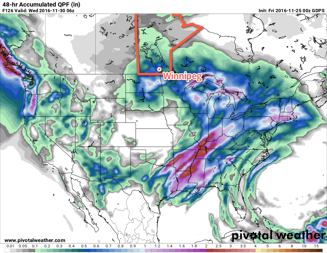
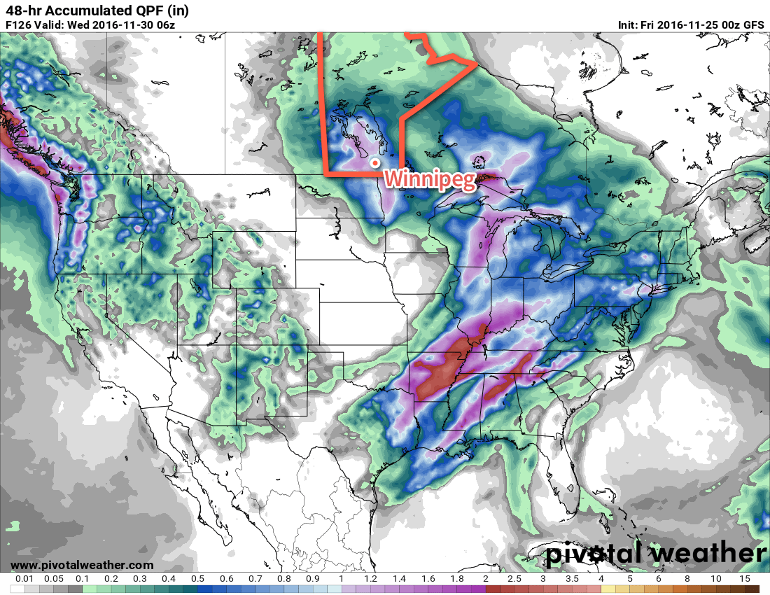
The big challenge with this system, should it actually hit the Red River Valley, will be what will actually fall out of the sky. Best indications are that much of what falls may actually be rain rather than snow, but it’s far too early to put too much stock in any particular forecast other than saying that this system, should it hit Winnipeg, will likely bring a wintery mix to the region. We’ll be keeping an eye on it as the system develops!

Winnipeg’s seasonal daytime high is currently -5°C while the seasonal overnight low is -13°C.


  1. Most forecast models show clear skies in the afternoon behind the warm front, however a few outliers want to keep things cloudy. At this point, with a broad southwest to westerly flow expected in the warm sector, I think that skies should manage to clear out, but we’ll keep an eye on things incase pesky cloud manages to stick around. 
  2. The mean temperature is an average of high and low temperatures of each day. 

Coldest Weather So Far This Season Arrives In Big Pattern Shift

An increasingly active storm track will bring a major winter storm through the Northern Plains of the U.S., drawing colder arctic air southwards cross the Prairies and ushering in the coldest temperatures seen so far in the fall of 2016.

Today will start with a weak system pushing through the Red River Valley, bringing with it a band of showers that will lift northeastwards across the region through the first half of the morning. After that moves through, we’ll be left with fairly cloudy skies as temperatures climb to a high near 9°C. Winds will pick up out of the southeast this morning to around 20-30 km/h, then taper off for the afternoon. Expect the winds to pick back up out of the northwest later in the evening with a slight chance of some very light rain showers or snow flurries overnight as a cold front moves through and temperatures dip down to the 0°C mark.

Thursday will bring mainly cloudy skies as a Colorado Low strengthens south of the border. Winds will be breezy out of the north to northwest at around 20-30 km/h and temperatures will climb to a high of about 3°C.

This history of forecast precipitation for Friday's Colorado Low shows how the GDPS model has developed consistency only in the last day and a half.
This history of forecast precipitation for Friday’s Colorado Low shows how the GDPS model has developed consistency only in the last day and a half.

Since last weekend, it’s been quite clear that a major winter storm was possible on Friday, and that much it got right. However, what at one point looked like a major blizzard for the Red River Valley has since turned into a moderate-strength winter storm for the Dakotas and Minnesota into Wisconsin. There’s a whole discussion on long-range model forecasts, but we’ll leave it at this: while it may get the general pattern right, don’t trust it on the details.

So what will we see instead of a blizzard? Cloudy skies and a stiff north wind likely at 40 gusting to 60 km/h. The southeastern portion of the province may get clipped with some snow from this system, but here in the Red River Valley, the system snow should miss us. There may, however, be a sneak attack from the north as cooler air surges southwards and lake-effect snow fires up over the lakes. Areas in the lee of the lakes may see some light to moderate snow flurries, however these will occur in fairly narrow strips and be highly dependent on the wind direction.

Temperatures will climb to only -1 or 0°C for a high. Expect the cloud and potential lake-effect snow to continue overnight as temperatures fall to a low near -4°C.

Long Range

The weekend looks cool with a continued chance for lake-effect snow through the day on Saturday. Cloud cover will be a mixed bag and highs will be near 0°C with lows near -6°C or so. If we get completely clear skies one night, then temperatures could plummet quite severely, though, so an overnight low below -10°C may be possible if the cloud manages to be scoured out of the Valley.

November “Heat” Continues

Our November “heatwave” will continue into early this week as temperatures remain well above normal. However, change is coming later this week as a strong low pressure system ushers in a much cooler air mass.

This Week

Today will be fairly nice in southern Manitoba. High temperatures will be near the 10C mark in most areas with mainly sunny skies to start the day. Clouds will begin rolling in as the day progresses, in association with a low pressure system pushing in from the west. This system may bring some light showers to southern Manitoba this evening and tonight, but no major accumulations are expected. Stiff southerly winds will be in place during the day with values of 30 km/h gusting to 50 km/h.

A nice Tuesday is expected, with mainly sunny conditions and “hot” temperatures yet again. The mercury should rise near the 10C mark, which is more than ten degrees warmer than normal for this time of year. Winds will be strong again though, with a westerly flow of 30 km/h gusting to 50 km/h.

Slightly cooler weather appears likely for Wednesday as another low pressure system begins pushing up from the south. As a result, skies will be mainly cloudy with a chance of showers or flurries throughout the day. Winds will be easterly at 20-30 km/h.

Long Range

Models have consistently advertised a strong low pressure system passing through the northern US later this week. This exact track of this system remains unclear, but it appears quite likely that it will usher in a much cooler pattern to southern Manitoba from late this week into the weekend.

While the current GDPS forecast has this storm completely missing Southern Manitoba, the GFS clobbers the region with heavy snow.

Should the system take a northerly track we will also have to contend with heavy precipitation, in addition to the cooler temperatures.

Warm Weather Brings First Major Spring Storm

While warmer will arrive in Southern Manitoba today with thanks to an abrupt switch to above normal temperatures, the bigger weather story on the horizon is the increasingly unsettled weather that will move into the region for the end of the week, culminating in what will most likely be the first major spring storm for Winnipeg & the Red River Valley.

Today will be the most pleasant day of the week as temperatures soar into the mid-teens with winds gradually increasing out of the southeast to around 30km/h for the afternoon. Skies will be fairly sunny, so all in all it will be a great day and boy, best to get out and enjoy it. Skies will begin clouding up tonight as the first of several systems approaches. Those breezy southeasterly winds will continue throughout the night. Into the second half of the night, some shower activity will begin spreading into the Red River Valley from western Manitoba.

Thursday will start off with some showers throughout the Red River Valley tapering off by mid-day. Temperatures will be quite mild with daytime highs climbing up to around the 17°C mark as a warm front pushes northwards out of the United States in response to a deep upper-level trough digging into the Plains from the Rocky Mountains.

GDPS 850mb Winds valid 06Z Friday Apirl 15, 2016
A strong southerly flow aloft will develop on Thursday, surging Gulf moisture northwards.

With the warm front developing over the region through the afternoon, a chance of some isolated showers or drizzle will continue throughout Thursday afternoon. Heading into Thursday night, the main event will begin to take shape: a major storm that will impact all of Southern Manitoba.

As this large-scale trough mentioned above develops, a significant amount of Gulf moisture will surge northwards through the Plains of the United States and head into Southern Manitoba, sending PWAT[1] values soaring to nearly 20mm above seasonal values. As a low pressure system pushes out of Wyoming and heads northeastwards into the Dakotas on Thursday night, a large area of rain will blossom over Montana, North Dakota and SE Saskatchewan and spread eastwards into Manitoba through the day on Friday.

GDPS 48hr. QPF Totals valid 00Z Sunday Apirl 17, 2016
While all the models show heavy precipitation for Southern Manitoba, they differ in placement.

The amount of precipitation is a relatively known quantity; it looks like 40-75mm over the course of 2 days is likely along the main axis of precipitation with amounts dropping to around 15-25mm along the edges of the precipitation. The challenge comes in where exactly this band of precipitation will set up, which will be determined by the position of the warm front and how far northwards it can push. The vast majority of the precipitation will fall to the north and northwest of the warm front, while drier and warmer weather remains to the south and southeast of the front.

There’s a chance that some of the rain may change over to snow on the western fringes of this system, most likely in the Melita, Virden and Minnedosa/Riding Mountain region. Depending on exact temperatures and the timing of the transition, it could mean a significant snowfall if the switch-over happens and it happens early enough.

For Winnipeg, the general consensus for 2-day totals tends to be around 45mm by Saturday evening. The nature of getting to that number varies, with the GFS producing a fair amount of rain on Friday and Saturday while the GDPS holds almost all the precipitation back until Saturday. We’ll have simply wait and see how exactly the warm front sets up to have a better idea of where the precipitation is going to fly.

Summary

Mild weather returns to Manitoba through the second half of this week, however with it will come the development of the first major spring storm of the year. A few showers will move through on Thursday morning, however the main event will occur through Friday and Saturday when a sharp warm front will separate temperatures in the mid-single digits over western Manitoba from near-20°C temperatures over southeastern Manitoba. To the north and northwest of this warm front, a significant rainfall event is expected, driven by a surge of moisture from the Gulf of Mexico as a deep long-wave trough digs into the Plains of the United States.

GDPS Forecast PWAT Anomaly valid 06Z Saturday April 16, 2016

By the time all is said and done, between 40-75mm is likely to have fallen along the axis of heaviest precipitation by Saturday evening. Where exactly this line lies will depend on exactly how far northwards the warm front is able to push; the uncertainty associated with this means that we simply have to wait and see how things develop to refine Winnipeg’s forecast for timing & amounts of precipitation.


With such a big system on the doorstep and so much uncertainty, we’ll be working ahead and getting our Friday forecast out at some point on Thursday evening rather than on Friday morning so that you can get a better idea ahead of time on what to expect for the weekend!

Winnipeg’s seasonal daytime high is currently 10°C while the seasonal overnight low is -2°C.


  1. Precipitable Water, a vertical integration of the amount of water vapour in a column of the atmosphere.  ↩