Elsewhere in Weather News: April 4th, 2015

Rare Rainfall Event Strikes Chile

A rainfall event that occurred near the end of March in Northern Chile did some major damage to numerous towns in the region. The storm system that brought the rain was the product of an upper level low that remained nearly stationary for several days in the area. The rainfall amounts, which might seem insignificant to Manitobans, are significant for that area because the storm system brought rain to one of the few places on the planet that receives very little precipitation every year – the Atacama Desert.

[map autofit=”1″ disable_scrollwheel=”1″][pin]Santiago[/pin][pin]Antofagasta[/pin][/map]

The flooding and mud flow event affected about 30,000 Chileans and destroyed 5,900 houses.  In the hardest hit regions only about 65mm of rain fell, but due to the extremely dry soil conditions in the region – which have trouble letting rainfall percolate through – flooding occurred. According to Wundergroud meteorologist Jeff Masters, Antofagasta recorded 24.4mm of rain in 24 hours while their average precipitation per year is 3.8mm. Santiago, Chile recorded 35.7mm of rain during the event, which is a significant amount in comparison to the 6mm total rainfall they typically receive during the entire month of March.

Aerial images of a flooded region in the Atacama just south of Antofagasta. (Source: Reuters)

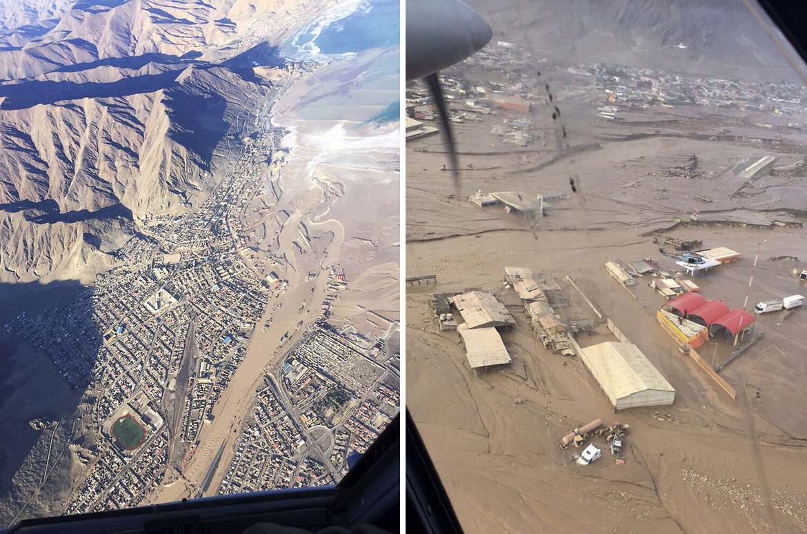
The flooding rains triggered flash floods which swept away cars, houses and washed away one of Chile’s main highways in 3 places in the normally arid part of northern Chile. In total, 24 people have perished from this event and there are still over 50 that are missing where the mud flows occurred. Rescue efforts are still ongoing for people in remote locations and the cleanup in the towns has begun as 7,000 troops have been brought in.


In other news, the Philippines are expecting typhoon Maysak to make landfall this weekend. Maysak was once a super typhoon (category 5) but has since encountered cooler waters of the Western Pacific and has weakened to a category 1 typhoon as of Friday night. The main risk with this storm is the heavy rainfall that it will bring to the Northern Philippines.

Elsewhere in Weather News: December 13th, 2014

West Coast Hit With Strong Winds, Heavy Rains

The West Coast of North America has been subject to several systems after coming onshore in the past couple weeks, bringing with them heavy rains and strong winds which has led to flooding. Once again, the culprit for the moisture-laden systems in this region has been the atmospheric river. This atmospheric river is a term used for streams of moisture typically originating in the tropics, which head Poleward. Eventually the water precipitates out – it is often enhanced along the west coast due to orographic precipitation, leading to flooding.

Higher PW values streaming from the tropics to the Californian coast are associated with the atmospheric river. (Source: CIMMS)

Earlier this week, the BC coast was hardest hit where over 400mm fell on parts of Vancouver Island in 6 days. Flood watches were issued as towns on the Island watched waters rise. The towns of Courtenay and Port Alberni were soaked with over 150mm by Wednesday – some residents were forced to evacuate their homes due to the rising waters. Strong winds were also a problem; gusts over 100km/h were recorded across the coast, even in large cities such as Portland, OR. These winds knocked out power to roughly 75,000 residents in BC alone. In addition to the wind and rain, landslides also became of concern in Southern California. Saturated grounds led to a large slide in Camarillo Springs, CA, which affected over a dozen houses.

Estimated rainfall along the BC coast from December 4 to the 10th. (Source: Environment Canada)
Estimated rainfall along the BC coast from December 4 to 10. (Source: Environment Canada)

The system even brought a weak EF-0 tornado which was spun-up in one of the stronger rain bands that came onshore. The tornado passed through a small area in southern Los Angeles yesterday morning and stripped roofs of their tiles – no one was injured thankfully. Reports of 60-100mm were common along the Californian coast, but localized amounts of 200mm or higher did occur. The highest precipitation report as of Friday came from an area in the northern Sierra Nevada Mountains where 450mm of precipitation fell; the amounts here were enhanced by orography.

Unfortunately models are showing another system impacting most of the West Coast early next week, not leaving much time for things to dry out.

Elsewhere in Weather News: November 29th, 2014

Widespread Floods Affect Southern France

A low pressure system advecting plenty of moisture Poleward from the Mediterranean Sea was in place over south-central France on Monday making for a good setup of long lasting heavy rains. The rains, enhanced by scattered thunderstorms prompted Météo France to issue various warnings, from strong wind warnings to severe thunderstorm warnings in addition to the rainfall warnings. A few areas along France’s southern coast were particularly hard hit with rainfall totals between 180-210mm in six hours on Monday. In addition to that another general 40-50mm (some amounts higher locally) fell as the system was moving off on Tuesday. On Wednesday, another low pressure system quickly moved into the region, again bringing with it rain and more storms. There was also a report of a weak tornado accompanying the one of the storms.

With already saturated soils from earlier in the week, conditions were primed for overland flooding as the second system moved in. Helicopters and rescue workers were hard at work towards the end of this week as people got trapped in their vehicles and houses from the flooding in southeastern France. There were five deaths related to the flooding events and 6,000 households were without power. The damage from the unconfirmed tornado comprised of roofs blown off and trees uprooted.

Precipitation map (in millimeters) of the rainfall in Southern France on Monday only. (Source: Météo France)

Unfortunately the soggy weather is expected to stick around the region this weekend. The upper-level cutoff low located over Southern Spain will drift ever so slowly to the east but will bring with it more showers and rain to southern France.

In other news, a supercell hit Brisbane, Australia this past week and knocked out power to 90,000 residents. The storm brought just about everything with it; golf ball size hail, strong winds and flash flooding – damages are in the hundreds of millions.

Radar image at the time the supercell was passing over Brisbane. (Source: BoM)

Elsewhere in Weather News: November 15th, 2014

More Flooding Hits Italy

Italy has seen its fair share of rainfall this past week, especially in the northern tier of the country including the city of Milan. Trouble started off in early November when a system originating from the Mediterranean Sea brought abnormal amounts of moisture into the region, producing heavy rainfall over a sizeable portion of Italy. This system, associated with a slow moving negatively tilted trough, dug down into southwestern Europe and triggered isolated thunderstorms and widespread rain. The system dumped copious amounts of rainfall – over 100mm fell in northern parts of Italy. With already saturated grounds from previous events in the past few weeks, this meant trouble for some villages.

Milan and surrounding areas saw the worst of the flooding. Subway systems were inundated with water, streets were flooded with over a foot of water and schools were forced to close. Two rivers in the region, the Seveso and Lambro, overflowed their banks and contributed to the flooding. The flooding is responsible for five deaths and estimated damages in excess of 100 million dollars.

Significant repairs will have to be done to this central Milan canal wall and road which collapsed due to the saturated ground below that gave way. (Source: @SimoneEneaRicco)

Northern Italy will remain soggy over the weekend, with another 10-20mm expected due to the same slow moving trough which continues to linger. Throughout November Milan usually sees about 100mm of precipitation, but just half-way through they have already surpassed it.

By the beginning of next week there’s a good chance that things will start to clear up as a weak ridge builds in.