A Cooler End to the Weekend

We’ll see two more days of temperatures near or just above 0°C before a cold front sweeps through Southern Manitoba bringing minimal precipitation and cooler weather.

12hr. QPF valid Sunday morning

Precipitation amounts for Saturday night from the NAM forecast model.

Today and Tomorrow

We’ll be off to a cloudy morning with fog patches through the entire Red River Valley; the fog may be quite dense in some areas, so if you’re travelling be prepared to potentially face near-zero visibilities at times. The fog will lift through the morning and by mid-afternoon the sun should be poking out once and a while. We’ll be on our way to a high of around +1°C with light winds. We’ll see increasing cloudiness tonight as the aforementioned system pushes towards Southern Manitoba. The cloud cover will help us keep our overnight low a bit higher than it has been lately with the temperature only expected to dip down to about -5°C. It’s likely that well see the redevelopment of fog patches again tonight.

Friday

Fog patches lifting this morning with gradual clearing.
1°C / -5°C
Saturday

Fog patches lifting then a mix of sun and cloud.
3°C
Saturday Night

A few flurries with the risk of freezing rain.
-12°C

We’ll see temperatures slowly climb back up above 0°C today as the cold front approaches the Red River Valley. Any fog patches that form overnight will lift fairly quickly in the morning as we head into another nice day with a mix of sun and cloud as the temperature climbs to +2 or +3°C.

A cold front will sweep across the Red River Valley tonight, bringing some flurries with it. There’s some uncertainty to the distribution of the snow: the models tend to spread it out, but all simultaneously hint towards a narrow band of heavier precipitation setting up. It’s hard to tell what’s going to happen this early, but suffice to say that there will almost certainly be a few flurries with the potential for local accumulations of 2-4cm somewhere in the RRV. In addition to the snow, there will be the potential for some patchy freezing rain as there will likely be some precipitation before all our warmer air aloft is scoured out by the cold front. Accumulations of freezing rain should not be significant, but may be enough to slick up roadways a little.

Sunday

Saturday

Chance of flurries. Clearing.
-6°C / -15°C

There will be a few lingering flurries about on Sunday morning, but they should clear out by midday and skies will then clear out. Sitting on the back-side of the cold front, our temperature will only climb to around -6°C, although it might be a little colder than that if clouds linger further into the day.

It looks like the cold weather will only stick around for a couple days until temperatures rebound back to the 0°C mark.

Freezing Rain to Mark Return of Colder Weather

Our wild weather will continue as another low pressure system tracking through the northern Prairies will bring with it mild temperatures and the probable risk for freezing rain over the Red River Valley, including Winnipeg.

Sounding for Winnipeg @ 5:00PM Local Time

Sounding for Winnipeg at 5:00PM local time. Note the significant AFL shaded in red.

Warm air will be pumped over the Red River Valley today as strong southerly winds develop ahead of a major low pressure system set to bring heavy snowfall to the northern reaches of Manitoba. 850mb temperatures will climb to nearly +5°C today, providing an ample AFL[1]. The bulk of the precipitation with this system will be constrained to central and northern Manitoba, where anywhere from 5–20cm of snow are expected. Regions that were hit hard Monday will mostly be spared as the heaviest snow will fall further north than Monday’s system.

We’ll have breezy southerly winds in the Red River Valley today at around 40km/h with gusts to 60km/h with temperatures climbing all the way up towards –1°C by the late afternoon/early evening. As the warm front approaches the RRV in the late afternoon, it looks that an area of showers will blossom along it. There’s still some uncertainty in exactly where the precipitation will be and how quickly it will develop, but it looks probable that areas in the Red River Valley north of Morris will see freezing rain late this afternoon. Areas south of Morris have a very real chance as well, however there’s a little more uncertainty in how far south the band of showers will stretch.

We aren’t expecting huge amounts of freezing rain this afternoon; the quick-moving nature of this system will mean that even if the rain is intense, it’s likely that we’ll only 1–2mm of it. Keep in mind, though, that while 1–2mm isn’t a very significant amount for regular rainfall, it is a significant amount of freezing rain. It’s likely that the freezing rain will fall during the rush-hour period in Winnipeg and quickly turn roads into slick little skating rinks fairly quickly. If you drive to work, especially into or through the downtown core of Winnipeg, expect a slow commute this evening.

Skies will clear overnight as a weak cold front pushes across the RRV and Thursday will bring mainly sunny skies with temperatures falling through the day to –8°C by evening.. Winds will be breezy from the NW at about 30km/h before letting up in the afternoon. Another arctic ridge will push into Southern Manitoba, bringing another shot of cold weather with it. Temperatures will dip all the way to around –20°C on Thursday night and only recover to around –15°C on Friday.

Temperatures will level out a bit for the weekend with highs near –10°C for Saturday & Sunday, but it looks that a weak storm track will move over us, bringing cloudy skies and plenty of chances for light snow. We’ll have more on this weekend’s weather on Friday morning.

Northern Manitoba Communities Buried Under Massive Snowfall

An incredibly powerful low pressure system tracking through Northern Manitoba on Monday brought a nearly unprecedented snowfall event to many communities. Hardest hit were Norway House and Gods Lake Narrows[2] where over 2 feet of snow fell. Environment Canada sent out a brief summary yesterday on the event:

A major winter storm moved across Central Manitoba on Monday, bringing with it some very heavy snowfalls. The heaviest band fell from the Norway House area east to the Ontario border, with numerous public reports of knee- to waist-deep snow accompanied by drifting as high as two metres. Lesser but still significant amounts were received by the surrounding regions of Gillam, Grand Rapids, and The Pas.

Unofficial snowfall totals are as follows:

Location Snowfall
Norway House 60–90 cm
Gods Lake Narrows 60–90 cm
Island Lake 60 cm
Oxford House 45 cm
Cross Lake 30–40 cm
Gillam 35 cm
Grand rapids 30 cm
The Pas 30 cm
Mafeking 23 cm

While official snowfall records for northern Manitoba are hard to come by, it seems likely that these snowfalls are record-high snowfalls for a 24–36 hour period for Norway House, Gods Lake Narrows, and Island Lake. From what I could find, 1-day record-high snowfall totals in Northern Manitoba generally sit around the 40–50cm mark; these totals of 2–3 feet easily quash those records, and whether or not they end up as official “heaviest snowfall” records may come down to exactly how much fell in any given 24-hour period.

Norway House Snowfall Satellite Image

A visible composite satellite image from during Norway House/Island Lake snow storm.

The snowfall came from an extremely potent, moisture-laden low pressure system that managed to find the right combination of convective snowfall and duration. As shown in the satellite image above, a very strong moisture feed was evident as it surged northwards into the low pressure system rooted near The Pas. This system slowly tracked eastwards, producing heavy snow in the above localities for upwards of 18–24 hours.

A system like this is definitely an extremely uncommon one and is difficult to forecast due to the sparseness of surface observations and lack of RADAR imagery. It will likely be just now as this is published that some roads finally begin to be cleared and people are able to return to a more normal daily routine.

A further 5–10cm of snow is expected for the Norway House and Island Lake regions with the system passing through Manitoba today.


  1. Above Freezing Level  ↩
  2. Gods Lake Narrows is a small community north of Island Lake, MB.  ↩

Unsettled Weather Ahead

A warm but unsettled few days are ahead as mild Pacific air surges across Southern Manitoba.

850mb Temperatures valid this evening

850mb temperatures from the NAM valid for early this evening.

Snow will taper off early this morning with a lingering chance of a stray flurry or two sticking around through much of the day across the northern half of the Red River Valley. Southerly winds will pick up through the day to 30-40*km/h as the warm front alluded to in Wednesday’s post pushes into the Valley. Temperatures will warm up quickly as the front passes with temperatures climbing to around -4 or -3°C, a few degrees warmer than the seasonal normal of about -6°C. Temperatures will remain steady through the night as that south wind continues to keep us in the warm air.

Another disturbance will pass through the northern Red River Valley tonight, however there’s some uncertainty to the areas that precipitation will fall. It currently looks like most, or all, of the precipitation will fall north of Winnipeg, focused in the Interlake region. There’s a slight chance that it will fall a bit further south, clipping Winnipeg and other areas in the northern half of the Red River Valley. If any areas in the Red River Valley are affected by this disturbance, they’ll almost certainly have to deal with freezing rain as there will a massive AFL (Above Freezing Level) just off the surface where temperatures will be nearly +10. With precipitation falling through it, the AFL will cool to 2-3°C, which is still more than warm enough to melt any snow that will be falling into it. Potentail freezing rain accumulations will be light but not insignificant at 1-2mm. Just to reiterate, the risk area for freezing rain will likely be confined to the northern half of the Red River Vally.

In addition to the weather from this disturbance, there will be the potential for freezing drizzle through the entire RRV as warm, moist air overruns our cold snowpack.

Saturday and Sunday will be cloudy days with beautifully warm temperatures for this time of the year. Daytime highs will sit right around 0°C. There will be a slight chance of non-accumulating flurries Saturday night into Sunday, otherwise no significant weather is expected. As winds lighten up, there will be the potential for fog patches through the valley in the overnight hours.

A storm system looks to move into the area on Monday morning, bringing rain or snow in the morning and snow in the afternoon. There’s still uncertainty in the track of the system and how much of the precipitation will impact the Red River Valley, so we’ll be sure to provide an update or two in the comments below through the weekend. The one thing that is certain is that this system will mark a return to more seasonal temperatures as cooler air sweeps over Southern Manitoba in it’s wake.

A Mixed Bag On The Way

Today will bring warm temperatures along with a bit of light rain or snow as a Pacific system tracks through the Interlake towards Hudson Bay. Temperatures will climb above 0°C today before they gradually cool down by the end of the week to more seasonal values.

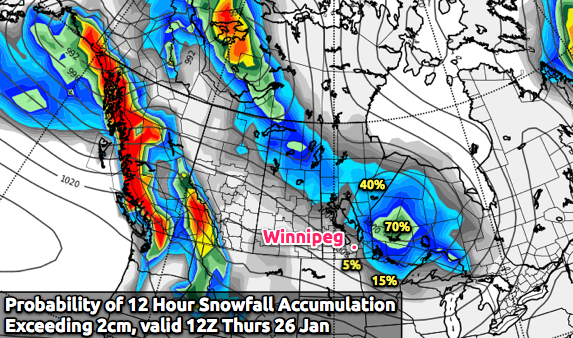
Probability of Snowfall >= 2cm

Probability of 12 hour snowfall accumulation exceeding 2cm, valid overnight Wednesday into Thursday morning.

A low pressure system tracking across the extreme Southern Prairies will arc northwards through Southern Manitoba today, lifting northwards through the Interlake region then exiting towards Hudson Bay. This system will intensify as it pushes into Manitoba and precipitation should blossom as it approaches the RRV. Two challenges exist with this system:

  1. When exactly will the precipitation develop/intensify?
  2. How far north with the system be?
  3. What will the phase of the precipitation be, snow or rain?

We’ll likely see some precipitation early this afternoon in the form of snow as the warm front pushes through the RRV. The Western RRV has a risk of some freezing rain if temperatures can stay below 0°C for long enough with this batch of precipitation. Any freezing rain that does develop will be short-lived, though. The snow will likely stop for the short period we’re in the warm sector of this system, but will return by late-afternoon/early evening with some rain or wet snow as the cold front passes through the area. The precipitation will end later in the evening. Snowfall accumulations today should be quite low in the RRV given the warm temperatures, however areas further east in the Whiteshell have a decent chance of getting around 2cm.

Temperatures should reach the 3-4°C range through most areas south of the Trans-Canada Highway today and drop only a little below 0°C overnight.

For Thursday, temperatures will reach close to 0°C as an elongated trough moves across the RRV, bringing with it a slight chance of flurries. It should pass by lunch, after which the NW winds will bring in cooler air and drop the temperature slowly through the afternoon.

The rest of the week will be relatively quiet, with temperatures gradually returning to more seasonal values (daytime highs moving from the low minus single digits to the high minus teens). The next chance for significant weather looks to be early next week.


Since it will likely be quiet on the weekend, I plan on having a bit of a special post on Friday! We’ll look at how warm this winter has actually been, and I’ll be unveiling a great new tool (barring no more problems…) that I’m really excited to let everybody get their hands on!