Arctic air will continue to build southward over the eastern Prairies in the coming days, bringing below-seasonal temperatures, variable cloudiness, and on Wednesday, some light snow.
Cloud will build into Winnipeg from the northwest later today as a cold front slumps southwards out of northern Manitoba, possibly bringing the occasional snowflake, but nothing that resembles accumulating snow. Temperatures remain cool with a high near -6°C, almost 9°C below seasonal for this time of year. Winds will continue out of the west at around 15 to 20 km/h through the day today. Skies should clear out overnight as temperatures head to a chilly low near -17°C. Winds will remain out of the west at 10 to 15 km/h.
Tuesday will see morning sun transition to mixed skies as another disturbance approaches from the northern Prairies. Temperatures will be similar to Monday with highs near -6°C again, but Tuesday night will be considerably warmer with lows near -9°C courtesy overcast skies that will move into the region. Winds will shift from west to northwest on Tuesday night, setting the stage for cooler air to move in on Wednesday.
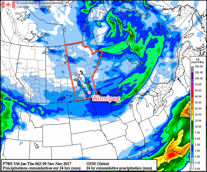
Some light snow is expected across much of southern Manitoba on Wednesday
Expect cloudy skies on Wednesday with some light snow and a cool high near -8C. Those northwesterly winds will likely fire up the lake-effect snow once again, enhancing the flurries to the south of Lake Manitoba and Lake Winnipeg.
Expect the clouds to persist much of Wednesday night with temperatures dropping to a low near -16°C.
Long Range Outlook
The remainder of the week will continue to bring mixed skies with the occasional chance for flurries. By Saturday, temperatures should begin to climb back towards the freezing mark, with near-seasonal temperatures expected to start next week!
Winnipeg’s seasonal daytime high is currently 1°C while the seasonal overnight low is -7°C.
Plenty of cloud and snow is in the forecast as one low pressure system leaves only to be quickly replaced by another mid-week. Temperatures will also remain cool as a large upper trough keeps the jet stream south and allows cooler Arctic air to spill into the Prairies.
Today will bring mainly cloudy skies to the region as a low pressure system that tracked through the region on Sunday pushes off into eastern Ontario. To start off the morning, widespread flurries in place across the region will taper off as a strong northerly wind of 40-50 km/h develops. Snow will taper off by midday for many locations except for two: those in the lee of Lake Manitoba and Lake Winnipeg.
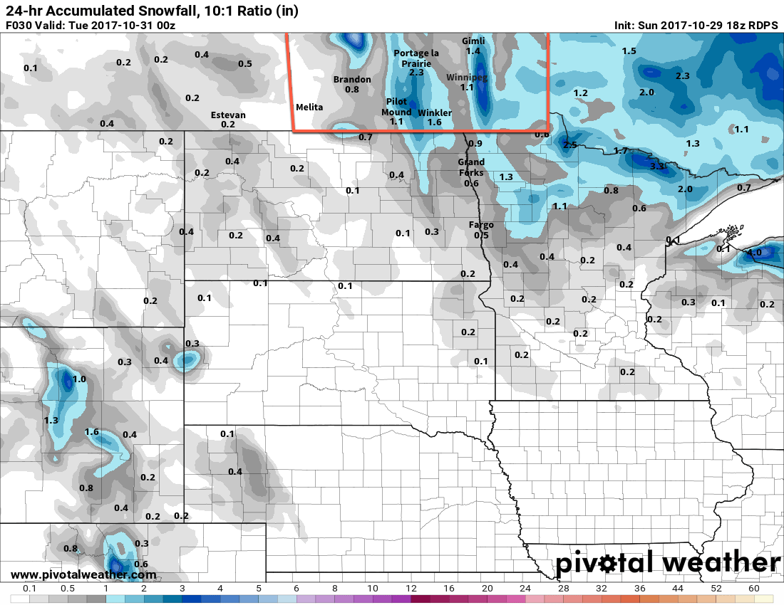
At a 10:1 snow-to-liquid water ratio, which may be low for the snow coming off the lakes, models suggest close to 10 cm of snow in the lee of Lake Winnipeg and Lake Manitoba
Strong northerly winds align along the basins of each lake this morning and persist all day, and as the colder air moves into the region, bands of lake-effect snow will develop and move southwards off the lake. The areas highlighted in the area above are the most likely to see snow and significant accumulating snow. Snowfall accumulations can be difficult to forecast in these events, but indications are that as much as 10 to 20 cm may fall by the end of the day under the heaviest band of snow. The Lake Manitoba event will taper off in the early evening as a ridge of high pressure moves in and eases the winds, while Lake Winnipeg will persist longer, weakening in the evening and ending overnight.
Aside from the snow, it will be a cool day whose high near -1°C will feel closer to -8 or -9°C with the strong northerly wind. Once the ridge moves into the area in the evening, winds will taper off and temperatures will head towards a low near -8°C under mixed skies.
Tuesday will bring benign weather to the region with mixed skies and temperatures climbing back to a high near -1°C. Winds will pick up out of the south through the morning hours, strengthening to 25 to 35 km/h for the afternoon hours. By evening, more cloud will be spreading across southern Manitoba in advance of the next low pressure system as it tracks across Saskatchewan. The cloud will keep temperatures a bit warmer overnight with lows of around -3°C. Winds will continue out of the southeast at around 20 to 30 km/h.
Wednesday will see the low and its associated area of snow move through the province. In the Red River Valley, snow will begin early in the morning and persist into the evening. As is the case with these early season events, the biggest challenge with this system will be the near-zero temperatures with daytime highs climbing to around 0 or +1°C and how that will affect how much snow accumulates versus melts. The expected snowfall is around 4 to 8 cm, but the actual accumulated amount will be less than that, with roadways likely ending up with a slushy centimetre or two by the end of the day, and grassy areas seeing closer to, but not the full, amount that falls.
Fortunately, winds will taper off in the morning, so visibilities will be as good as they can be with the snow falling. The wind will pick up out of the north in the afternoon into the 20 to 30 km/h range. The cloud cover will likely remain through the night with the potential for a bit of lake-enhanced/effect snow coming off of Lake Manitoba and Winnipeg. Temperatures will dip to a low near -6°C.
The only real uncertainty with this system is how far south it will end up going, and whether or not it will end up too far south to impact our region. The general consensus is that Winnipeg and the Red River Valley will see snow, but we’ll be keeping an eye on how it develops just in case.
Long Range
The remainder of the week doesn’t look much better; Thursday will see any remaining flurries taper off with a continued north wind that makes the high near -1°C feel rather cool. Temperatures will then dip down to the low minus single digits on Thursday night and rebound to just -2 or -3°C on Friday under mostly cloudy skies. Another cold night on Friday night will lead into highs returning to the freezing mark on the weekend, but that’s due to the approach of a mother system that will bring another wintery mix to the region late Saturday into Sunday.
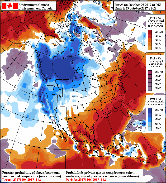
NAEFS 8-14 Day Temperature Anomaly Forecast — Valid November 6-13, 2017
Once that passes by, a significant chill will descend across the Prairies, bringing below-normal temperatures for an extended period, alongside the potential for more snowy weather.
Winnipeg’s seasonal daytime high is currently 4°C while the seasonal overnight low is -5°C.
Temperatures will be startlingly colder this weekend than we’ve seen through the first half of November, but despite the shock to the system, Winnipeg will simply be seeing temperatures closer to typical values for this time of year.
The weather through the weekend will be relatively benign overall, with the major storm system forecast once upon a time to slam the Manitoba Red River Valley now taking a significantly more southwards track, instead tracking across central Minnesota into Northern Ontario. With that major system moving through to our south, we’ll be left with cloudy skies and a brisk north wind to 30 gusting 50 km/h. Temperatures will be much cooler with a high near +1°C
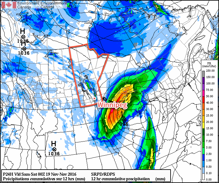
As cooler air slumps southwards through the day, narrow bands of lake-effect snow will fire up off of the south basin of Lake Winnipeg. At this point, it appears that the line will run north-south and primarily impact a line between Selkirk and St. Clements southwards towards Springfield. Beausejour may end up just east of the main band, but slight shifts in the wind direction could shift the heaviest band east or westwards. Lighter flurries may make it all the way south of Steinbach. By the time the lake-effect tapers off on Saturday morning, anywhere from 5-15cm of snow may accumulate under the heaviest axis of snow.
If you look to the northwest of the massive Colorado Low blob, a narrow band of lake-effect snow accumulation can be seen east of Winnipeg.
Skies will begin to clear out on Saturday night, save for locations that see cloud streaming off the lakes. Winds will taper off and temperatures should dip to a low near -6°C.
Saturday will bring a ridge of high pressure to the province, quashing the lake-effect snow and bringing a bit of sunshine and light winds. Highs will reach around 0°C under mixed skies. Saturday night will be partly cloudy with a low near -5°C.
Sunday will bring increasing cloud ahead of a warm front pushing eastwards across the southern Prairies. Temperatures will climb to a high near -1°C with a brisk southeasterly wind at 20-30 km/h. Expect fairly cloudy skies with a chance of some light snow on Sunday night with a low near -4°C.
Back To Normal
As mentioned up top, while these cooler temperatures are a shock to the system, we’re simply in a rapid adjustment back towards seasonal temperatures.
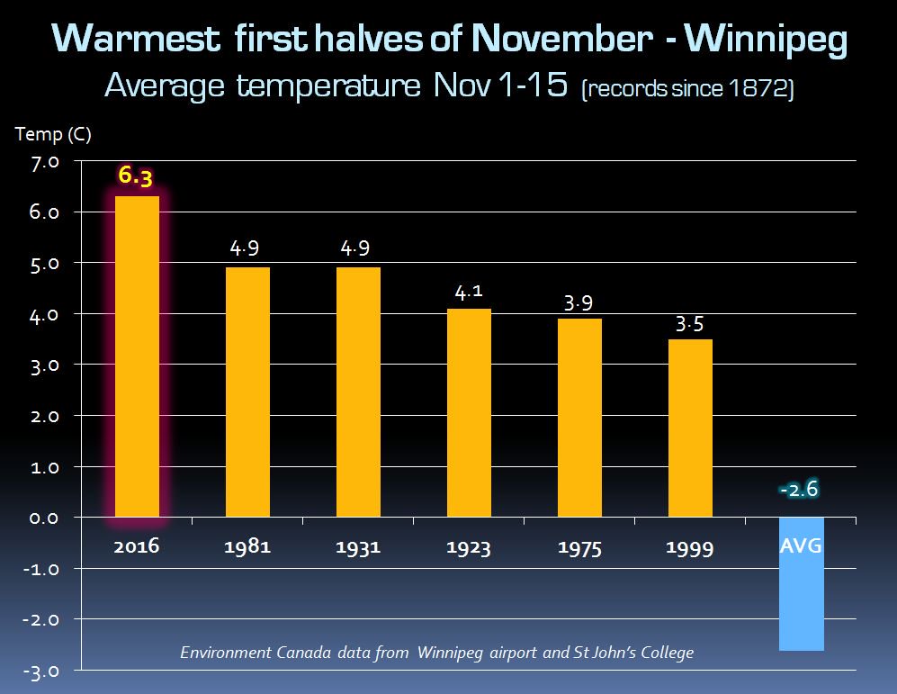
November has been a phenomenally warm month so far, with an average high of 11.3°C, a whopping 9.8°C warmer than the typical average high of 1.4°C through the same 17-day period. Including overnight lows, mean temperatures have been over 6°C above normal, more typical of mid-October than November, and November 2016 has taken the crown with the warmest first half1 of November on record.
Top 6 warmest first halves of November in Winnipeg on record. Credit: Rob’s Obs
And, while a brief seasonal snap is on the way, models indicate that by next weekend above-normal temperatures will be back in full force, which could enter the month into the competition for warmest November on record!
Long Range
The system pushing the warm front eastwards across the Prairies on Sunday will continue to push eastwards and bring another chance for snow to the region on Tuesday. After that, it appears that a series of low pressure systems will track to our north and begin building warmer air back into the Prairies.
Winnipeg’s seasonal daytime high is currently -3°C while the seasonal overnight low is -11°C.
First half of November is November 1-15, inclusive. ↩
An increasingly active storm track will bring a major winter storm through the Northern Plains of the U.S., drawing colder arctic air southwards cross the Prairies and ushering in the coldest temperatures seen so far in the fall of 2016.
Today will start with a weak system pushing through the Red River Valley, bringing with it a band of showers that will lift northeastwards across the region through the first half of the morning. After that moves through, we’ll be left with fairly cloudy skies as temperatures climb to a high near 9°C. Winds will pick up out of the southeast this morning to around 20-30 km/h, then taper off for the afternoon. Expect the winds to pick back up out of the northwest later in the evening with a slight chance of some very light rain showers or snow flurries overnight as a cold front moves through and temperatures dip down to the 0°C mark.
Thursday will bring mainly cloudy skies as a Colorado Low strengthens south of the border. Winds will be breezy out of the north to northwest at around 20-30 km/h and temperatures will climb to a high of about 3°C.
This history of forecast precipitation for Friday’s Colorado Low shows how the GDPS model has developed consistency only in the last day and a half.
Since last weekend, it’s been quite clear that a major winter storm was possible on Friday, and that much it got right. However, what at one point looked like a major blizzard for the Red River Valley has since turned into a moderate-strength winter storm for the Dakotas and Minnesota into Wisconsin. There’s a whole discussion on long-range model forecasts, but we’ll leave it at this: while it may get the general pattern right, don’t trust it on the details.
So what will we see instead of a blizzard? Cloudy skies and a stiff north wind likely at 40 gusting to 60 km/h. The southeastern portion of the province may get clipped with some snow from this system, but here in the Red River Valley, the system snow should miss us. There may, however, be a sneak attack from the north as cooler air surges southwards and lake-effect snow fires up over the lakes. Areas in the lee of the lakes may see some light to moderate snow flurries, however these will occur in fairly narrow strips and be highly dependent on the wind direction.
Temperatures will climb to only -1 or 0°C for a high. Expect the cloud and potential lake-effect snow to continue overnight as temperatures fall to a low near -4°C.
Long Range
The weekend looks cool with a continued chance for lake-effect snow through the day on Saturday. Cloud cover will be a mixed bag and highs will be near 0°C with lows near -6°C or so. If we get completely clear skies one night, then temperatures could plummet quite severely, though, so an overnight low below -10°C may be possible if the cloud manages to be scoured out of the Valley.