Elsewhere in Weather News: January 4th, 2014

Snowstorm Sweeps across Northeast US, Cold Temperatures Follow

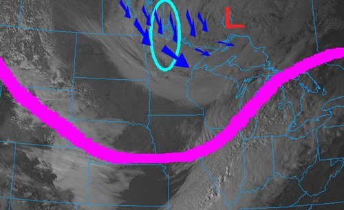
A powerful low off the Atlantic coast impacted the Northeast US this past Thursday/Friday bringing heavy snow to the region and blizzard-like conditions. Blizzard warnings were issued for Cape Cod and surrounding regions as winds howled around 70km/h and heavy snow fell. Conditions did improve snow-wise late Friday, but very cold Arctic air ushered in behind the low was of concern. In total, about 4,500 flights were cancelled out of New York alone, causing problems for holiday travelers. Schools and most government offices were closed in Washington DC on Friday due to the adverse weather conditions. Boxford, Mass appeared to be hardest hit with snowfall totals around 60cm, however, Boston was not far behind with 45cm followed by New York’s 25cm. On Friday night 16 deaths had been reported to be associated with the storm.

Temperatures are expected to rebound and warm up for the Northeast as another low pressure system approaches, from the west. It will draw in some warm air; highs Sunday (overnight) are even expected to rise in the (positive) double digits making for a 30°C temperature swing in less than 48 hours for parts of the Northeast.


Arctic air infiltrates across the Northern Plains, US Midwest behind the low centered in southern Quebec. Valid Monday morning. (Source: Twisterdata)

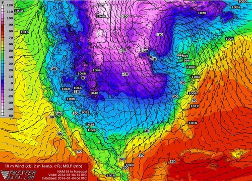
Some potentially record-breaking low temperatures are expected on the horizon for the Midwest behind this system though, as the polar vortex pivots all the way down to the Midwest. On Friday the Governor of Minnesota had already cancelled schools state-wide on Monday in preparation for this next potent blast of Arctic air that will make its way east.

Elsewhere in Weather News: October 6th, 2012

Record Early Snowstorm Hits Northern States

The same powerful low pressure system that brought the first significant snowfall of the season to Southern Manitoba dropped copious amounts of snow south of the border. A surface low pressure system that was moving in a north-easterly fashion combined with a deepening upper low through the area resulted in a record-breaking early winter storm this past week in North Dakota and Minnesota.

Visible satellite

Image of visible satellite taken on Friday afternoon. Large upper low is located in NW Ontario with jet stream in pink and cyan circled area the hardest hit areas. (Image source: COD)

Impressive snowfall totals were recorded in Northern Minnesota and North Dakota in the wake of the storm. Numerous cars were spotted in the ditches and tractor-trailers jackknifed in Northern Minnesota on Friday, due to treacherous road conditions. Around 3,000 people were out of power in the two states on Friday afternoon in the hardest hit areas. Woodridge, MB to Thief River Falls, MN received the heaviest bands of snow. Below lists some of the impressive amounts of snow accumulation recorded in Minnesota and North Dakota, as per reported by the National Weather Service:

  • Badger, MN (30 minutes south of Piney, MB): 30-36cm
  • Roseau, MN: 18cm
  • Grand Forks, ND: 9cm – A record for largest amount of snow to fall this early in the year (old record: 5cm)
  • International Falls, MN: 4cm – Also a record for the largest amount of snow to fall this early in the year (old record: 1.5cm)

(The remainder of the reports as of 3pm, Friday afternoon can be seen at http://www.crh.noaa.gov/news/display_cmsstory.php?wfo=fgf&storyid=87914&source=0)

This snowfall brings to a close (for now) the extreme fire danger in North Dakota and Minnesota whose conditions were similar to Southern Manitoba – extremely dry and windy. The Karlstad fire in Minnesota on October 3rd was fanned by severe 65km/h winds and drought conditions. In total, 31 buildings were destroyed; thankfully, no one was hurt.

Damage

Picture of the damage in Karlstad. (Source: MPL/Nathaniel Minor)

As the low pressure system continues to move further north-east, areas in Northern Ontario such as Timmins and Geraldton will experience their first snowfall of the year.