July Finishes Slightly Cool with Near-Normal Rainfall

July 2017 spent much of it’s time with below normal temperatures — 16 of 31 days had daily mean temperatures below the 30-year average — but was still generally pleasant with much fewer days of rain than in June and many daytime highs that were close to seasonal values.

The first third of July consisted of a swing from well below-normal temperatures to well above normal temperatures followed by a brief period of near-normal temperatures. The deviations from normal more-or-less cancelled each other out with a month-to-date departure from normal of -0.2°C by July 10th. For the next 14 days, though, Winnipeg fell into a prolonged period of below normal temperatures with daily means generally 1.5 to 2.5°C below normal. By July 23rd, Winnipeg’s month-to-date departure from normal had fallen to -1.2°C. The end of the month saw an abrupt turnaround, though, as hot and humid weather moved into the region. Several days saw high temperatures in the upper 20’s to low 30’s and overnight lows in the mid- to upper-teens.

No record temperatures were set in July, however.

By the end of the month, the warm spell had allowed the monthly mean temperature departure from normal to recover to -0.4°C.

In other temperature statistics:

  • July 2017’s average high temperature was 25.7°C, just -0.1°C below the 30-year average of 25.8°C.
  • July 2017’s average low was 12.5°C, -0.8°C below the 30-year average of 13.3°C.

Near-Seasonal Rain at the Airport

While there was only rain on 8 of 31 days in July, total rainfall ended up near-normal with 71.1 mm.

While it rained infrequently, the Winnipeg airport measured a total of 71.1 mm of rain through July 2017, 90% of 30-year normal of 79.5 mm. Much of the rain fell on just 3 days: July 11 (21.7 mm), July 21 (14.1 mm), and July 22 (14.3 mm). The combined 3-day total of 50.1 accounted for 70% of the month’s rainfall.

The 8 days of measurable precipitation was a welcome improvement from June which saw 14 days of measurable precipitation. The concentration of the bulk of the rain into just 3 days did make for some drying, though, and some gardeners likely needed to begin watering their plants occasionally again.

It is worth noting, however, that rainfall was variable throughout the city. At my Glenwood personal weather station I measured slightly less at 68.6 mm. Some locations over south and eastern Winnipeg saw as little as 50-55 mm while other locations across the west side of the city saw up to 85 mm.


So in the end, July 2017 was a very nice rebound from June. There were few days with rain, quite a few days with near-seasonal highs and a lack of humidity that brought more frequent slightly below-normal temperatures at night.

August seems to be continuing the trend so far with near-seasonal highs and cooler nights courtesy a lack of humidity. No complaints from this author!

Unless otherwise noted, all normal values referred to in this post use the 1981-2010 normals for Winnipeg, Manitoba.
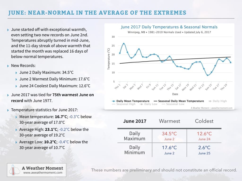
The Average of the Extremes Made June A Near-Seasonal Month

June 2017 started off with exceptional warmth as daily mean temperatures1 climbed 5-10°C above normal, a sharp break from a cool end to the month of May. Temperatures peaked on June 2nd when two new records were set in Winnipeg:

  • Record daily maximum of 34.5°C, breaking the old record of 32.2°C set on June 2, 1948.
  • Record warm daily minimum of 17.6°C, breaking the old record of 17.5°C set in June 2, 1988.

The warmth continued with above-seasonal temperatures gradually trending towards seasonal values by mid-June.

A significant pattern shift occurred on June 15th, shifting Winnipeg into a prolonged period of below-normal temperatures that would end up lasting the remainder of the month. Temperatures bottomed out on June 24th when Winnipeg set a new record:

  • Record cold daily maximum temperature of 12.6°C, breaking the old record of 13.9°C set in 2004.

Temperatures then moderated to near-normal for the last few days of the month.

From record-setting warmth at the beginning of the month to record-setting cold at the end of the month, June 2017 averaged out to near-normal with a monthly mean temperature of 16.7°C, which was just -0.3°C below the normal monthly mean of 17.0°C. Perhaps a notable example of how the mean can be misleading.

In other temperature statistics:

  • June 2017’s average high temperature was 23.1°C, just -0.2°C below the 30-year average of 19.2°C.
  • June 2017’s average low was 10.2°C, -0.4°C below the 30-year average of 10.7°C.

Perhaps Not As Wet As You Think

Many people think of rain when they think of June, and it certainly had its fair share of precipitation with accumulating rainfall measured on 14 of 30 days, largely clustered between June 9th and 25th where there was measurable rainfall on 12 of 17 days.

While it rained frequently, total rainfall was actually below normal. The Winnipeg airport measured a total of 51.5 mm of rain through June 2017, well below the normal of 90.0 mm. So despite seeing many damp days, Winnipeg ended up with only 57% of the normal rainfall for the month.


So in the end, June 2017 was not quite what it seemed. Despite a mean monthly temperature near-normal, it was actually a month that progressed from record warmth in the first half to record cold in the second half. Despite raining almost half the days of the month, it ended up with just over half of the normal rain accumulation.

June 2017 Temperature Summary – Winnipeg, MB

July is off to a much more consistent start with seasonal to slightly above seasonal temperatures and dry conditions. We’ll be keeping track of how the rest of the month progresses!

With regard to climatological normals in this post, we are using the 1981-2010 Climatological Normals for the Winnipeg International Airport.


  1. The daily mean temperature is the average of the daily maximum temperature and daily minimum temperature.