Elsewhere in Weather News: November 9th, 2013

Super Typhoon Haiyan Plows into Philippines

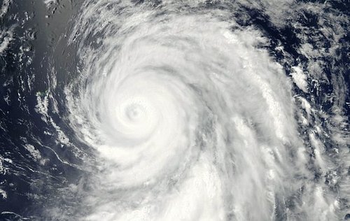
One of the strongest storms ever recorded on the planet formed this week in the Western Pacific and eventually made landfall over the Philippines on Thursday. Early estimates from satellite data suggest that this super typhoon was the fourth strongest ever recorded and strongest to make landfall, since record keeping began.


Impressive image of Haiyan Thursday afternoon as it neared peak intensity, about 5 hours before making landfall. Extremely cold cloud tops can be seen around the eye. (Source: Co. State University)

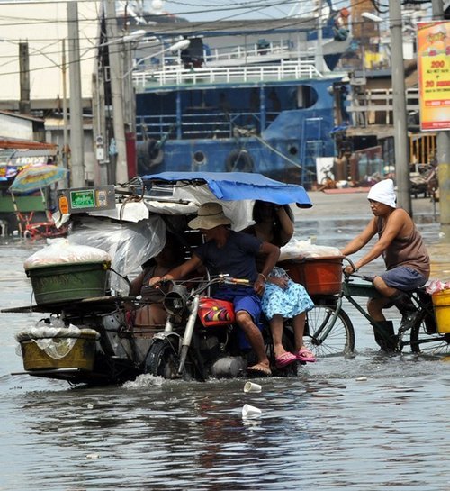
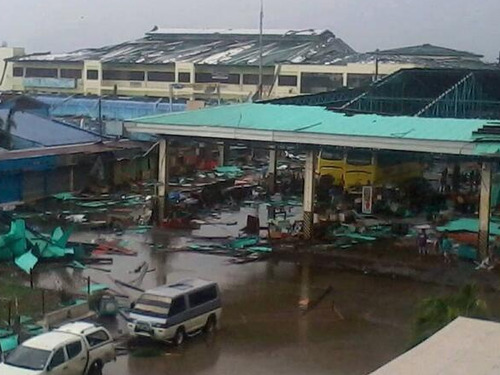
Haiyan brought just about every type of severe weather you could experience with a typhoon; extremely strong winds with central pressure below 900mb, very heavy rains causing flooding and a powerful storm surge. The category five typhoon brought intense sustained winds in the order of 300km/h, gusting to over 350km/h and a storm surge of over 15 feet. Reports of damage are still coming in as of Friday night as communication to the islands hardest hit has been knocked out. Tacloban, a city of about 215,000 residents looks to be the hardest hit where damage is significant, storm surge swamped first and second floors of buildings and high winds tore apart buildings. It’s difficult to put an estimate on damage and death toll at this point.


Picture of some of the damage to a bus terminal in Ormoc City (located south-west of Tacloban). (Source: R. Deleon)

Haiyan continues its trek this weekend as it moves over the South China Sea towards Vietnam. It is expected to make landfall on Saturday overnight as a category two typhoon. Haiyan’s passage over the Philippines weakened its inner core as well as slightly cooler sea surface temperatures and higher shear values have all contributed to Haiyan’s slow weakening. Regardless, the typhoon still needs to be watched closely as it approaches Vietnam as flooding and landslides are expected to be a big problem.

Footage of super typhoon Haiyan making landfall in the Phillipines
An update on Haiyan as well as an update on the cleanup in the Philippines will be posted later this weekend.

Elsewhere in Weather News: December 8th, 2012

Typhoon Bopha Makes Landfall

(Follow-up to last week’s EIWN article “Typhoon Bopha Takes Aim at the Philippines”)

Typhoon Bopha made landfall on Monday, December 3rd, on the southernmost island of the Philippines. The typhoon was classified as a dangerous category five, where winds exceeded 250km/h. As expected with category five typhoons, the devastation and destruction caused extensive damage to infrastructure and crops; one fourth of the banana crops in the region were destroyed. As of Friday, December7th, it was reported that over 500 people had died as a result of the storm, and about 350 were still missing. Rescue workers are working feverishly, looking for survivors assumed to be trapped in their houses because of mudslides, or gold miners trapped in mines. In total, Bopha displaced about 250,000 Philippine residents who mostly took shelter in public buildings to ride out the storm. The Red Cross is providing funds and food to the ravaged country. Bopha appears to be the strongest, southernmost typhoon on record, to have ever affected this region of the Philippines.

Bopha

Infra-red satellite image of Bopha on Friday evening. It does not have a distinct eye and is showing signs of weakening. Forecast track is in white. (Source: CIMSS)

After Bopha made landfall in the Philippines, it emerged into the South China Sea and has re-strengthened to a category three hurricane with a well-defined eye. Its track has taken a northerly direction which was followed by a north-easterly track, which means its outer bands will affect the north-west islands of the Philippines later this weekend. Bopha will continue its somewhat circular track and is predicted to eventually head out in a south-westerly manner towards Vietnam next week. There is a lot of uncertainty as to what will happen after that, but there are some signs that show the storm will weaken off to a tropical depression.

Damage

Incredible damage in New Bataan, a southern Philippine city. (Source: AFP)

In other news, New Zealand experienced its deadliest tornado on record this past week where an EF-2 struck a suburb of Auckland and killed three people. It’s not a common sight to see such a strong tornado in Auckland but the conditions on December 6th greatly contributed to this, as warm, humid air, fueled severe thunderstorms in that area.

Short collection of videos of what it was like being inside the New Zealand Tornado. (Source: AP)

Elsewhere in Weather News: December 1st, 2012

Typhoon Bopha Takes Aim at the Philippines

A strong typhoon dubbed Bopha has spun up in the Northwest Pacific Ocean this past week and is taking aim at the Philippines. The typhoon is currently located at 4.5°N which means that it’s still located within the Intertropical Convergence Zone (ITCZ). This is an area north and south of the equator where north-east and south-east winds meet and cause daily convectional thunderstorms. Near the equator, there is little Coriolis effect which would explain why tropical cyclones rarely form (lack of spin). Since Bopha will move towards the west north-west, it will hold together. If it were moving towards the equator, it would be less likely that it would maintain form.

Typhoon tracks

All typhoon tracks between 1985 and 2005 with equator and Bopha’s approximate location (pink). (Source: Wiki Images)

Bopha

Bopha’s basic into from Friday night, it’s expected track and strength. (Source: Humanitarian Early Warning Service)

It’s expected that Bopha will strike south of Manila and likely make landfall on the Island of Samar on early on Monday, December 4th. It is likely to be a violent typhoon, bringing severe storm surge, copious amounts of rain to areas that are prone to mudslides and flooding. Winds will almost certainly be a problem as it’s predicted that Bopha will make landfall as a category 3, accompanied by winds around 200km/h. As of Friday evening the storm already had a central pressure of 965mb with sustained winds near 200km/h. On Friday evening, it was quickly intensifying with very cold cloud tops around its centre and a well-defined eye was starting to develop.

Microwave imagery - Bopha

Microwave imagery from Bopha on Friday night. The eye was becoming well defined. (Source: CIMSS)

IR Satellite - Bopha

Infra-red satellite imagery from Bopha as a category 4 hurricane. (Source: CIMSS)

On average, the Philippine Islands see an average of 9 hurricanes make landfall annually, with 1-2 usually developing in the month of December. Their peak season for typhoon activity runs at about the same time as the Atlantic Hurricane Season, though it’s not unusual to see typhoons in that area after November 30th.

Elsewhere in Weather News: June 23rd, 2012

Typhoons and Hurricanes Spin Up in Northern Hemisphere

Mother Nature has been very busy world-wide, wreaking havoc of all forms this past week. The Deluth floods, tornadoes in South Dakota, and as reported in today’s EIWN post—typhoons and hurricanes have spun up in the North-West Pacific and North Atlantic basins.

This past Sunday, June 17th, typhoon Guchol (known as Butchoy by the Philippines) gave a scare to the Philippine islands’ residents as it scooted a couple hundred kilometers to the east of the islands while racing northwards. Minor storm surge and the outer spiral bands of Guchol brought heavy rains and flash floods to the area. Making matters worse was the fact that the monsoon winds were occurring, feeding warm, moist, air from the equator. The streets in Manila were flooded requiring people to walk through waist-high water to reach their destination. Landslides caused by the heavy rains were also reported in the region. The eye of the typhoon didn’t hit land in Manila however; it kept roaring in a northerly fashion towards Japan where it finally made landfall on Tuesday. Intense winds were recorded above 200km/h near the eye of the storm. Flash-flood conditions existed in areas where the typhoon made landfall and near the core, through the more mountainous regions of Japan. About 80 people had injuries relating to the storm and one person died when his house was torn apart by the vicious winds. Since then, Guchol has been downgraded to an extratropical storm and has weakened significantly as it’s path continues over land and it moves away from the warm sea surface temperatures that gave it it’s energy.

Manila flooding

Streets of Manila completely underwater. (Source: Ted Aljibe/RT)

Guchol

Image of Guchol racing towards Japan in the North-West Pacific Ocean. (Source: NASA)

Meanwhile, in the North Atlantic, the third-named storm of the year, Hurricane Chris, formed far off to the south-east of Newfoundland, in the middle of the North Atlantic but poses no threat to land. This hurricane is only the second most northerly hurricane in the history of record keeping. It managed to form in the 22°C waters of the North Atlantic Ocean, bringing us to wonder whether it developed due to global warming or is just a glimpse the planet’s extremes?

Later this weekend various models are hinting at a tropical storm forming in the southern half of the Gulf of Mexico. Other than that, models are in disagreement and all over the place regarding which way future “Debby” will be heading.

Debby

NAM’s projection of where Debby will be Sunday morning. (Source: TwisterData/AWM Model Viewer)