Gloomy Thanksgiving Monday

This Thanksgiving will be nothing like last year’s (which featured temperatures in the twenties), as rain and wet snow make for a rather miserable holiday Monday.

Total precipitation accumulation for Monday's system

The GEM model shows generally 10-20mm of precipitation over Southern Manitoba

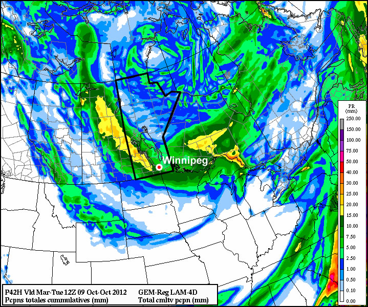
A low pressure system sliding south-eastward through Manitoba on Monday will be responsible for the precipitation, with rain beginning to move into Southern Manitoba early Monday morning. Temperatures on Monday will be cool, but generally not cold enough for snow with values hovering in the mid single digits during the daytime. By evening there will be a changeover to snow in some areas, mainly portions of Western Manitoba, as colder air is pulled down from the north. Areas in the Red River Valley can expect a bit of wet snow late Monday evening into the overnight period, but with surface temperatures remaining above zero, no notable accumulation is expected. Total precipitation accumulations will generally range from 10 to 20mm across Southern Manitoba by early Tuesday.

Unfortunately, conditions will improve little for Tuesday. It will be a chilly start to the work-week as cold air pulled down by the previous day’s low pressure system will not allow temperatures to climb much higher than the mid single digits at best. Monday’s low pressure system will have departed by Tuesday morning, so no more significant precipitation is expected (save for perhaps a few scattered showers or flurries). At this point models keep us in the single digits for Wednesday as well, so even normal weather will continue to elude us.

The late week period looks to remain fairly miserable, with temperatures staying stuck in the single digits. No more significant precipitation is expected later this week.

Elsewhere in Weather News: September 1st, 2012

Tropical Depression Isaac: Update

What was once dubbed Hurricane Isaac when it made landfall as a category one hurricane, is now considered a ‘tropical depression’. Isaac continues to pose a threat a week after it made landfall but it has weakened significantly, and will continue to do so, as it penetrates further into the southern half of Continental United States. Although this hurricane was “only” rated a category one when it made landfall, comprising of maximum sustained winds of 135km/h at peak intensity, you would have not guessed the incredible amounts of rain it brought into Louisiana and surrounding Gulf States. Here are a couple of the most impressive rainfall totals recorded throughout the whole event:

-In Gretna, LA, the National Hurricane Center (NHC) unofficially reported 466mm of rainfall.
-In New Orleans, LA, 510mm of rainfall was reported, breaking New Orleans’ old daily rainfall record by 48mm (a record thsat was set by Hurricane Katrina).
-In Kiln, MS (west of Gulfport) 433mm of rainfall was reported.

Not only did Hurricane Isaac bring with it enormous amounts of rain, the storm surge that accompanied it was quite severe. Wind-driven storm surge is mostly caused by the severe winds accompanying a hurricane. These winds push ocean waters towards land similar to a wave but larger in size (in this case with south winds) and in turn, ocean levels are higher than the normal tide. This phenomena makes for serious flooding along the Gulf Coast since the terrain along the Gulf of Mexico is not mountainuous – it is more of a gradual slope. When ocean water then rises, it is easy for it to move inland quickly.

Isaac storm surge

Hurricane Isaac’s wind direction depicted with arrows. Blue boxes along the shoreline show areas where winds were favorable for storm surge. Green arrows (north winds) is where storm surge was less favorable because of the wind direction. Picture was taken just before landfall on the night of August 28th. (Source: NOAA)

In Louisiana, two people lost their lives in the Plaquemines Parish, one of the hardest hit parishes, as the tide rolled in and consumed their house. This now brings the Hurricane Isaac death toll in the United States to four, with damages listed in the hundreds of millions. In Louisiana and Mississippi, power was out to over a million people and it was estimated that 75% of New Orleans was out of power when the eye wall passed closest to the city. For a storm being of weak category one, it did an extensive amount of damage. This was in part caused by it’s broad area of precipitation, large area extending out from the eye of tropical storm force winds, extremely slow movement, and storm surge levels you would expect form a category two or three hurricane.

Flooding

Residents evacuating in Lafitte, LA by boat because of flooding. (Source: Yahoo News)

This week in the tropics there are three other notable storms: Hurricane Kirk out in the middle of the Atlantic which poses no threat to land; Tropical Storm Leslie which does not pose a threat to the United States but as it strengthens, could pose a threat to Bremuda; and lastly, Hurricane Ileana out in the Eastern Pacific poses no threat to land but could cause high surf to the Baja Peninsula.

Stormy Night Ahead; Cooler Weekend

Another 30°C+ day will give way to stormier weather tonight as a cold front pushes across Southern Manitoba. We’ll see a slightly cooler weekend than the weather of late as we remain in the cooler air behind this system.

Precipitable Water for Friday Night

Precipitable water from the GEM-REG as the cold front pushes into the RRV tonight. Elevated values of 40-50mm through the RRV indicate the potential for stronger storms with locally heavy rainfall.

We’ll see temperatures climb into the low 30’s across Southern Manitoba again today as we remain under the influence of a pool of warm air entrenched over the Eastern Prairies. After some of this morning’s debris cloud from last night’s nocturnal convection clears out, here in Winnipeg we’ll climb to a high near 31 or 32°C, while areas to our south could reach as high as 33°C today.

Things will change promptly this evening as a cold front pushes across the province. Showers and thunderstorms will develop along the front in the early to mid-evening and continue to grow in coverage as the night progresses. This line of showers and thunderstorms will move through the Red River Valley overnight, bringing 5-15mm of rain to the region, the potential for some areas to see a bit over 1” total accumulation, and hopefully a good light show. These storms are not expected to be severe, and could potentially be one of the last night-time light shows we’ll get in 2012.

Tomorrow we’ll see a daytime high only around 24°C with a southwesterly wind at 20-30km/h. Sunday will reach about 25°C with lighter winds. Skies should be mostly sunny both days, with just an occasional cloudy patch here and there.

Temperatures are expected to climb back towards the 30°C mark through the first half of next week.

Hot Weather Returns

After a period of cool weather over the last while, warmer conditions are set to return.

30C temperatures are expected on Tuesday in Southern Manitoba

The NAM model is predicting that Southern Manitoba will see temperatures of 30C or higher on Tuesday

A ridge of high pressure will build over the Prairies this week, allowing for some of the warmest weather we’ve seen this August to develop. Monday will be a pleasant day, with high temperatures in the mid to upper twenties. By Tuesday many areas should see their first 30C readings this month, as warmer air pushes in from the west.

The ridge will begin to break down on Wednesday and Thursday as a series of impulses move in from the Pacific. These impulses with have one or more low pressure systems associated with them, causing some unsettled weather to start developing over the Prairies later this week. It looks like an easterly flow will develop over Southern Manitoba on Wednesday out ahead of an approaching low. Depending on how the frontal features setup on Wednesday we may or may not see another 30C day. At this point it looks most likely that Wednesday will have temperatures in the upper twenties, rather than thirty, but there is the potential for warmer weather. On Thursday we may see our first risk of thunderstorms in a while as a strong southerly flow draws up more humid air from the south ahead of an approaching low pressure system.

As we move toward the weekend weather models show a series of fairly strong low pressure systems moving through our region. Should these systems develop more or less as predicted it would likely mean a rainy and cool last weekend of August.