Severe Thunderstorm Threat Followed By More Unsettled Weather

Hot and humid weather over southern Manitoba will lead to a thunderstorm outbreak on Tuesday afternoon. A cold front will slowly push across the region on Wednesday, bringing more showers with a risk of thunderstorms again, though severe weather is less likely. One last blast of unsettled weather will develop Thursday evening in North Dakota and spread into Manitoba overnight. By Friday, Winnipeg will see some more settled conditions.

RDPS 2m Temperature Forecast valid 21Z Tuesday June 20, 2023
It will be another hot day over the Red River Valley with highs in the 30s with dew points climbing over 20 °C.

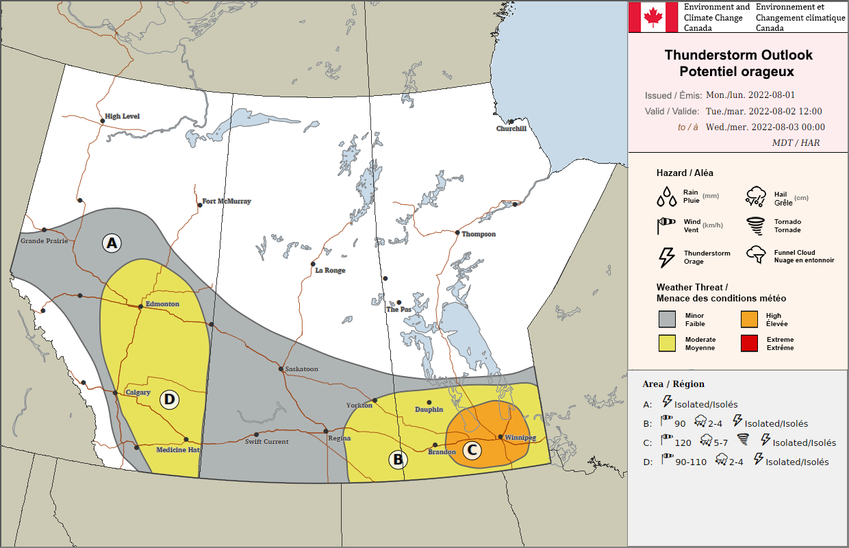
There is a notable severe thunderstorm threat today in southern Manitoba as a hot and humid air mass continues building into the region. The main drivers of the weather today will be a warm sector trough that will arc from north-central North Dakota into the Interlake this afternoon and a cold front that is gradually shifting eastwards from the Manitoba/Saskatchewan border.

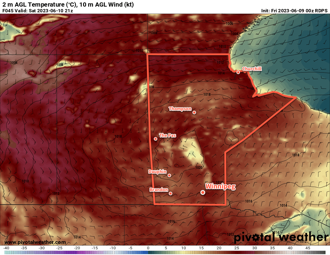
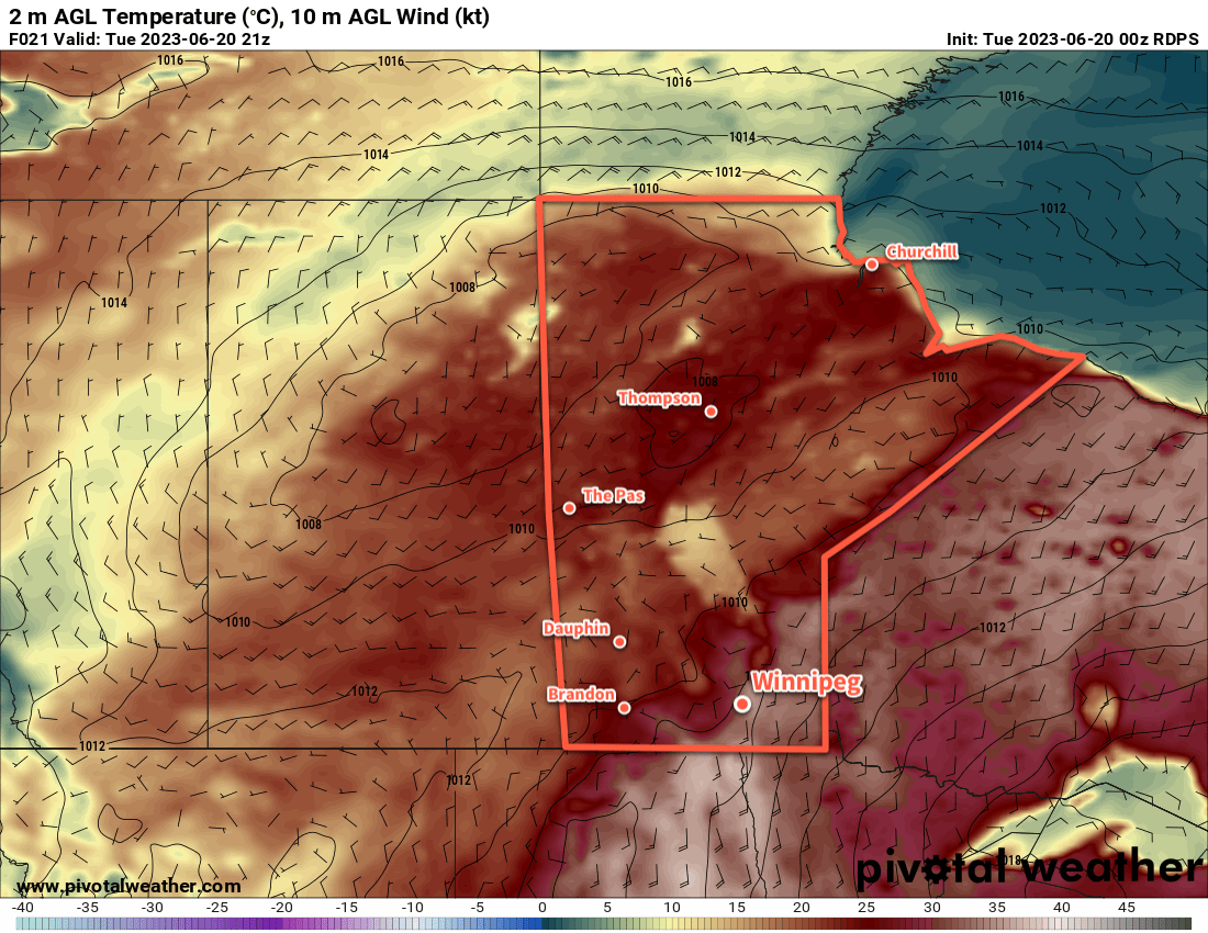
Along and east of the trough — which includes the Red River Valley — very hot and humid conditions will develop today. Daytime highs will climb into the low to mid-30s with dew points climbing up to around 20 °C. This will produce widespread humid values in the upper 30s or low 40s across much of south-central and southeast Manitoba. As this air mass cooks, it will bump up against the warm sector trough as it slowly shifts eastwards through the day.

By mid-afternoon, very significant amounts of energy for thunderstorm development will have built up in southern Manitoba. A quick summary of the afternoon’s convective parameter forecasts: MLCAPE values in the 2,000–3,000 J/kg range, bulk shear values of 25–45 knots, shear vectors aligned roughly along the convergence boundary, and STP values ≥ 1.

NSSL-WRF Forecast MLCAPE valid 21Z Tuesday June 20th, 20233km NAM Simulated Reflectivity valid 02Z Wednesday June 21, 2023
The NSSL-WRF model (left) shows clearly the axis of significant instability that develops on Tuesday afternoon. By 7PM CDT, thunderstorms will begin to develop and quickly grow into a complex of [potentially severe] thunderstorms within a couple hours (right).

The end result of all the parameters is this: thunderstorms will redevelop this afternoon and there will be numerous severe thunderstorms. Primary threats today will be very large, damaging hail and torrential rain. With so much energy to work with, it’s also likely that some thunderstorms will be able to produce damaging wind gusts. An isolated tornado or two is possible today, particularly early in the storm development later today.

Be sure to be aware of any severe weather watches or warnings issued by the Meteorological Service of Canada through the day today.

The thunderstorm activity will continue into the night, growing upscale along the trough and slowly shifting eastwards. Activity will refocus further south overnight where another disturbance riding northeastwards along the cold front, spreading more showers with the risk of thunderstorms into southern Manitoba by Wednesday morning. With the cold front further east, Winnipeg will see cloudier conditions through the day but temperatures could still be quite warm with highs in the upper 20s. Thunderstorm activity on Wednesday will be weaker overall than today, with a much lower risk of any severe-level activity.

More rain and thunderstorms is possible overnight Wednesday into Thursday as another disturbance rolls into the province along the slow-moving frontal boundary. It will support an area of nocturnal convection that will push into southern Manitoba, bringing what could be another widespread area of precipitation. There will be much less instability by this point, so little to no severe weather is likely with this final round of showers. This system will also bring cloudy skies to the region for much of Thursday with highs finally dipping back down into the mid-20s. The humidity stuck in the region will also finally begin to ease as the cold front slowly shunts southeastwards.

Long Range Outlook

More unsettled weather is likely this weekend as an upper low treks northeastwards out of the American Rockies, bringing a broad area of rain into southern Manitoba. There’s still some uncertainty associated with this system, but at this point it looks like a widespread 25 to 50 mm could be possible across many parts of southern Manitoba through a combination of rain and embedded thunderstorm activity. This system will clear out of the region to start next week, followed by another chance of showers on Monday evening as a cold front slumps into the region.

All in all quite an unsettled week ahead of us with numerous chances for showers and thunderstorms across the region. Particularly today, be sure to keep aware of the day’s thunderstorm development given the notable risk of severe weather.

Today’s seasonal daytime high in Winnipeg is 24 °C while the seasonal overnight low is 11 °C.

Cold Front Brings Relief From Hot and Humid Weather

A cold front passing out of the province today will usher a cooler and drier air mass into southern Manitoba. This will bring a welcome break from the hot and humid early-June weather the region has seen, along with more settled conditions.

RDPS 2m Temperature Forecast valid 21Z Saturday June 10, 2023
On Saturday, a high pressure centre moving in from the north will bring cooler daytime highs in the low 20s to southern Manitoba.

A cold front will sweep through southern Manitoba this morning, bringing some cloud, a slight chance of showers or thunderstorms, and a breezy northerly wind. In Winnipeg, any chance for rain should end by midday, leaving dry conditions and a high in the mid-20s. Unfortunately, the city won’t see clear skies in the afternoon; behind the cold front, smoke from the northern Prairie forest fires will push into the region. It may end up being fairly noticeable for a few hours after the passage of the cold front, otherwise it should mainly appear as haze and not have too significant an impact on air quality. The winds will ease in the evening, then temperatures will head to an overnight low in the low teens, the coolest in a while.

Through the weekend, a large area of high pressure will settle into the region. Saturday and Sunday won’t bring cloud to the region, rather it will largely just be a question of how much smoke lingers over the region. Temperatures will be cool on Saturday with a high in the low 20s and a low near 10 °C. Temperatures will begin to warm on Sunday with a high back in the mid-20s and a low in the mid-teens.

Long Range Outlook

To start next week, daytime highs will once again climb back to around 30 °C. The humidity levels will stay much lower and keep the heat a bit more comfortable than last week. By mid-week, conditions could turn unsettled again and bring the chance of showers or thunderstorms to the region for several days.

Today’s seasonal daytime high in Winnipeg is 23 °C while the seasonal overnight low is 10 °C.

Warm With Increasing Humidity This Week in Winnipeg

After the scorching heat last week in the Winnipeg region, it might seem like this week will be cooler with highs of only the upper 20s. That slight cooling will be offset by more humidity in the region, with humidity levels possibly reaching downright muggy levels by Friday.

GDPS 2m Dew Point Temperature Forecast valid 00Z June 3, 2023
A extended southerly flow will bring a more humid air mass from the Gulf of Mexico northwards to southern Manitoba by the week’s end.

It will be another unsettled day in the Winnipeg area thanks to a shortwave lifting across the region from the Dakotas. As it moves into the warm and relatively humid air mass in our region, scattered showers and thunderstorms will once again develop. These will persist through the afternoon and into the evening before tapering off.  The city will see a high in the mid-20s give way to an overnight low in the mid-teens.

Heading into mid-week, an upper ridge will begin to build over Central Canada. It will bring warmer temperatures to the region while also supporting a deep southerly flow from the Gulf of Mexico northwards through the American Plains. Daytime highs will rise into the upper 20s, but at the same time, an increasingly muggy air mass will build northwards. Dew point temperatures will increase from around the mid-teens to close to 20 °C by Friday. This will make for very muggy conditions to end the week that will make the highs in the upper 20s feel more like the mid-30s.

Along with the heat and humidity will come some unsettled conditions as well. Isolated to scattered [thunder]showers may be possible as the week progresses.

Long Range Outlook

Very warm conditions will return for the weekend with daytime highs likely climbing into the low 30s. If the humidity remains high, then it would almost certainly result in another heat warning for Winnipeg and the Red River Valley. Again, though, it won’t be completely stable and some showers or thunderstorms will be possible through the weekend.

More settled conditions will return next week as the humidity begins to leave the region. With a drier air mass, highs will hover in the upper 20s with overnight lows in the mid-teens through the first half of next week.

Today’s seasonal daytime high in Winnipeg is 22 °C while the seasonal overnight low is 8 °C.

Early Week Heat Brings Chance of Thunderstorms

A low pressure system crossing the province will bring hot and unsettled conditions to southern Manitoba today. The heat will be short-lived, though, as a cold front ushers seasonal temperatures back into the region for Wednesday.

RDPS 2m Temperature Forecast valid 21Z Tuesday August 2, 2022
A low pressure system moving into Manitoba today will bring hot, humid conditions to the region.

In the wake of a warm front that moved through overnight, temperatures will soar into the upper 20s and low 30s across southern Manitoba today. Alongside the heat, humidity levels will also climb through the day, reaching fairly muggy levels by the evening.

Thunderstorm activity will be the most notable, and challenging, weather of the day. There will be several features moving through the region that that may support thunderstorms today. The first will be an area of showers and thunderstorms — the remnants of overnight convection — that will continue eastwards through the Interlake. This activity will weaken as the morning progresses. While most of it should stay north of the Red River Valley, the southern edge might clip along the Trans-Canada Highway corridor. The second feature will be the warm front itself, which may have some ongoing thunderstorms along it this morning. Any activity along it should shift eastwards into the Whiteshell and then weaken.

Once all the morning activity pushes out, the Red River Valley will see more sun as things heat up. Later in the day, a risk of severe thunderstorms will develop as several features begin pushing across southern Manitoba. Both the low centre, warm-sector trough, and cold front could support thunderstorm development later today. The heat and humidity will combine with favourable winds aloft to pose a notable risk of severe weather.

ECCC Prairie Thunderstorm Outlook valid 1:00PM to 1:00AM CDT
ECCC’s Thunderstorm Outlook issued on Monday afternoon shows a notable severe weather threat for southern Manitoba on Tuesday.

The combination of energy (from the humidity and instability) and shear (from how winds change with height) is highly favourable for severe thunderstorm activity across southern Manitoba today. The biggest uncertainty with storms in the afternoon/evening will be whether or not they actually develop. A layer of warm air aloft will keep storms down until late in the day. It seems likely that the forcing will be strong enough by evening for isolated to scattered thunderstorm development. The activity will likely begin in the southwest and push into the Red River Valley. These thunderstorms would be capable of producing damaging wind gusts, damaging hail, and torrential rain. In addition, an isolated tornado or two may be possible with these thunderstorms as well.

The last unknown related to thunderstorm development will be exactly how warm temperatures end up. Satellite imagery yesterday evening showed a fair amount of high-level smoke moving eastwards from fires over southern British Columbia. If that smoke inhibits temperatures even a couple degrees, that could be enough to thwart thunderstorm development. All those things being taken into account, the weather later today is a bit of an unknown. It will be important to stay up to date on any watches or warnings issued by ECCC later today.

The thunderstorm threat will diminish in the evening as temperatures fall to a low in the mid-teens. Winnipeg will see pleasant conditions on Wednesday with clearing skies, breezy northwest winds, and a high in the low 20s. On Thursday, breezy southerlies will push a warm front northwards and send highs back into the upper 20s. Thursday night might be very warm with southerlies continuing and lows warmer than 20 °C possible.

Long Range Outlook

Friday could bring some morning showers or thunderstorms to the Red River Valley, followed by mixed skies and a high in the upper 20s again. It might also get humid on Friday as well.  A cold front will sweep through by Friday evening, ushering cooler temperatures back into the region for the weekend. Highs will likely sit in the low 20s with lows in the low to mid-teens on Saturday and Sunday. A few showers might be possible on Sunday as well.

Next week is looking like it will start off with near-seasonal temperatures and plenty of sunshine.

Today’s seasonal daytime high in Winnipeg is 26 °C while the seasonal overnight low is 13 °C.