Unsettled Weather Returns to Winnipeg for the Weekend

Showers and thunderstorms will once again make their return to Winnipeg & the Red River Valley for the next few days…with a catch. Despite the unsettled weather, it might end up actually being fairly pleasant this weekend for the most part!

Today will be a bit of a mixed bag with some cloudy periods and a high near 21°C. Winds will pick out out of the south to around 30km/h or so through the day.

The first of two systems that will be affecting Winnipeg & the Red River Valley today will be a convective complex lifting northeastwards out of North Dakota. It will spread cloud and a chance through southeastern Manitoba, with just a slight chance of some midday showers in Winnipeg.

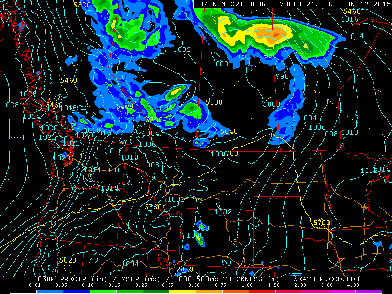
The second system that will bring a risk of showers or thunderstorms to Winnipeg is a trough of low pressure that will move into our region tonight from Saskatchewan. There still exists quite a bit of uncertainty as to whether or not any precipitation will push into the Red River Valley tonight; in general, confidence is much higher over eastern Saskatchewan and southwestern Manitoba, where a significant threat for severe thunderstorms exists today.

AWM Convective Outlook for Friday June 19, 2015
A moderate risk of severe thunderstorms exists over SE Saskatchewan & extreme SW Manitoba today.

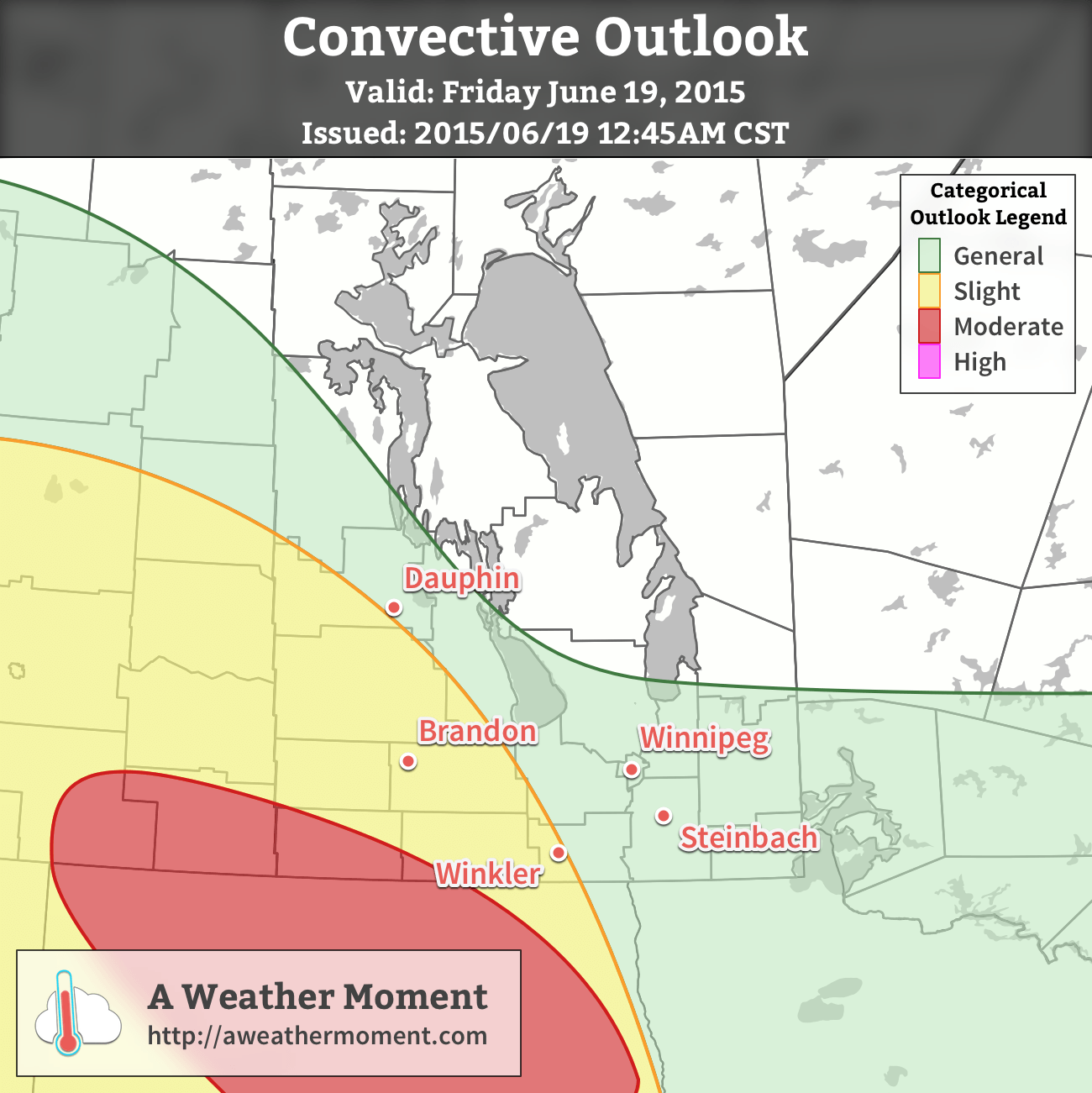
The most likely outcome at this point is that much of the convection heading towards the Red River Valley will either taper off or dive south into North Dakota where a severe convective event called a bow echo seems probable. There is a slight chance that we’ll see some thunderstorm activity in the Red River Valley overnight, but it doesn’t appear that it would be severe.

Saturday looks like a fairly pleasant day with mixed skies about and a high near 22 or 23°C. There will be a chance for showers late in the day into the evening hours, but in general the activity isn’t expected to be very widespread over the Red River Valley. The temperature looks to drop into the low teens on Saturday night.

The threat for thunderstorms returns to the Red River Valley on Sunday afternoon as another disturbance moves through the region. Temperatures will once again top out in the low 20’s with overnight lows dropping into the low teens.

Father’s Day Forecast Update

Father’s Day
25°C / 15°C
Mainly sunny

Weather will be generally pleasant for Southern Manitoba this Father’s Day with generally sunny skies and high temperatures in the mid-20’s with fairly light winds. This is excellent news for the Manitoba Marathon; today will be a far nicer day to run than last year’s less than pleasant weather. The only exception will be in areas along a line from Swan River east-southeastwards across the Interlake towards Berens River where some pop-up showers and thunderstorms are possible this afternoon.

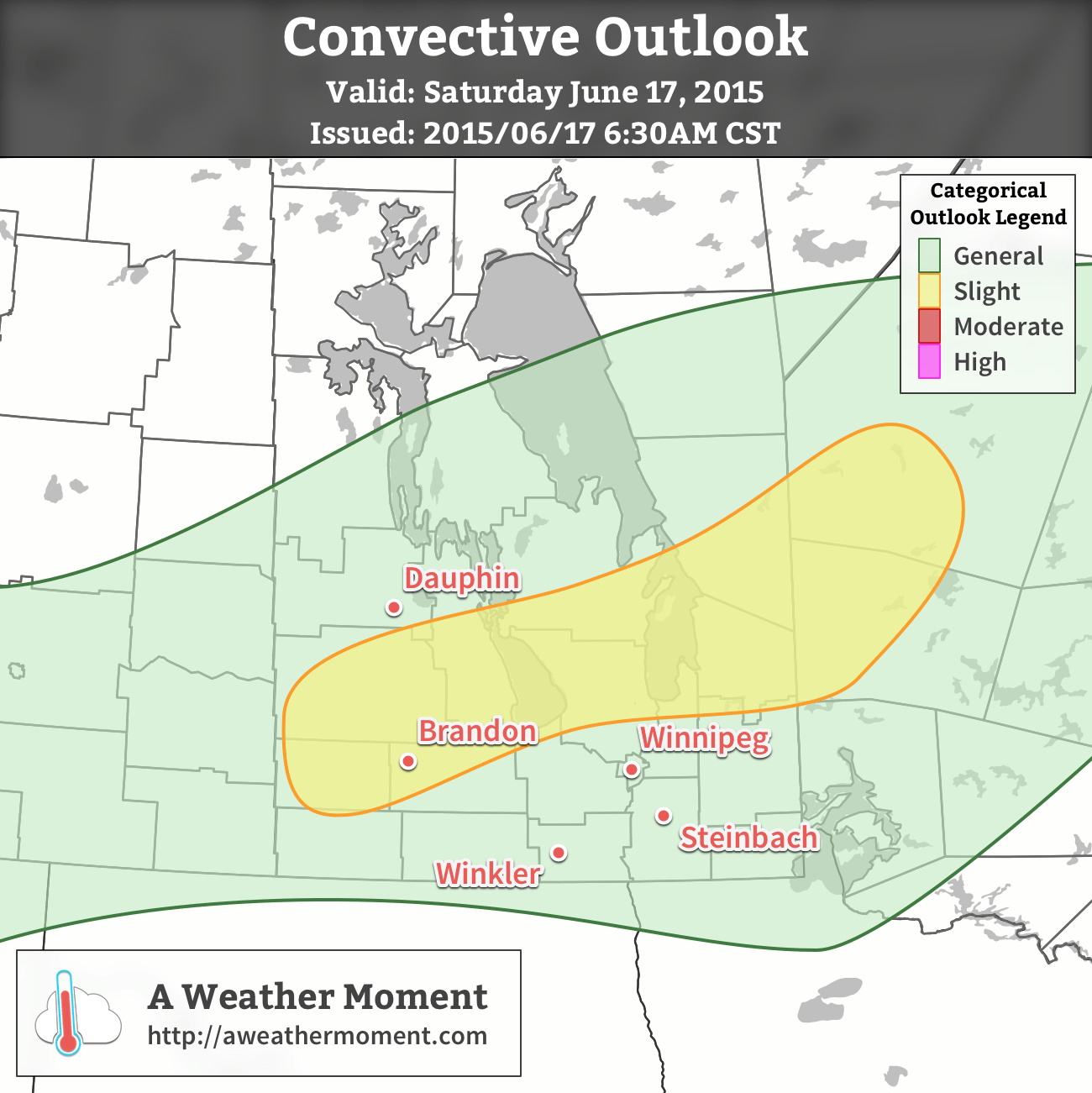
An more organized thunderstorm threat will develop through the day, however, beginning early-to-mid-afternoon in Saskatchewan and then progressing eastwards through southwest Manitoba this evening and through the Red River Valley overnight. Thunderstorms are expected to develop in the Regina area southwards towards the American border; these storms will be developing in an area with marginal energetics, however very favourable shear profiles will likely result in scattered thunderstorms with isolated supercell thunderstorms. As they track eastwards, a southerly low-level jet will intensify, supporting upscale growth of the convective complex as it heads into the evening.

AWM Convective Outlook for Sunday June 21, 2015
A slight risk of severe thunderstorms exists over SE Saskatchewan today and will spread into Southern Manitoba this evening & overnight.

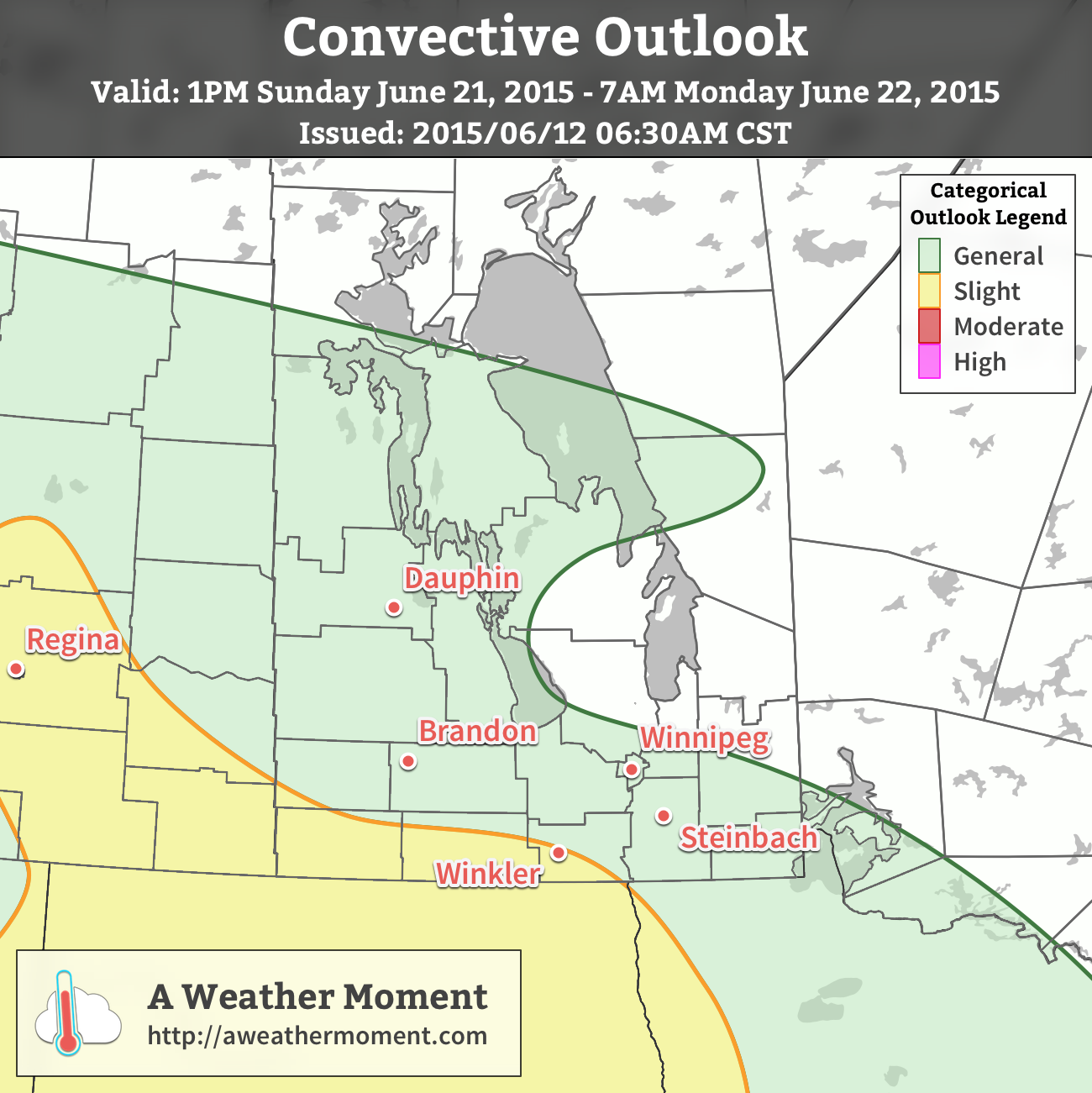
I expect that early in the evening, the thunderstorms will have developed into a line of showers and thunderstorms heading eastwards into Southern Manitoba. In general, the severe threat in Manitoba is expected to be minimal, except for areas near the U.S. border. There is a chance that as the storms push eastwards, supported by a 50-60kt westerly jet at 500mb and running just north of a warm front in North Dakota, that the storms develop bowing segments. Bowing segments are when the thunderstorms produce strong winds that, quite literally, push part of the storm forward, making a ) shape on RADAR imagery.

Primarily for that reason, I’ve carried a slight risk for the overnight period along the US border into the Red River Valley; I’m generally expecting the worst weather to dive into North Dakota fairly early, but there’s a slight chance some of the winds end up remaining on the Manitoba side. For the remainder of the general area through southwest Manitoba into the Red River Valley, non-severe nocturnal thunderstorms are possible through the evening/overnight period.

Thunderstorms Return to Southern Manitoba

Showers and thunderstorms will make a return to Winnipeg & the Red River Valley today as a cold front sweeping southwards across the province moves through later this afternoon.

AWM Convective Outlook for June 17, 2015
A slight risk of severe thunderstorms is expected over Parkland Manitoba eastwards through the Interlake. A general risk of thunderstorms exists throughout the Red River Valley including Winnipeg.

Wednesday

Wednesday
24°C / 9°C
Afternoon showers or thunderstorms

Today will be quite a pleasant day until the front arrives; temperatures should climb to around 24°C before the front swings through with gusty winds out of the southwest at 30km/h.

The cold front will work its way through the Red River Valley from around 4 to 8PM, with a fairly large band of showers and thunderstorms along it. The thunderstorm threat doesn’t look too severe, however. Using the MIST principles:

  • Moisture: Dewpoint values will be fairly limited today with little moisture transport taking place, leaving and moisture accumulation to relatively local effects. Some moisture pooling ahead of the front should allow surface dewpoints to climb to 13–14°C, however the moisture will be quite limited in its vertical extent.
  • Instability: Overall instability looks sufficient for thunderstorms, but within that context, fairly marginal. Surface-based CAPE values will be around 1000 J/kg, however due to that shallow layer of moisture, mixed-layer CAPE values will be around half that.
  • Shear: Actually quite favourable! Around 30–40 kt of 0–6km bulk shear is expected primarily through speed shear, which should provide adequate support for the development of thunderstorms.
  • Trigger: This is perhaps the most favourable component of the whole day: the cold front is quite potent. Strong convergence will be in place along the front, providing ample forcing for the development and sustainment of thunderstorms.

In general, we’ll likely see a fairly widespread band of showers and thunderstorms develop along a line from SW Manitoba northeastwards through the Interlake early in the afternoon, then see it slowly progress to the SE through the rest of the day.

The main threats from the storms will be strong winds and heavy rain. The wind threat will come from fairly strong winds aloft coupled with fairly dry low-levels that may aid in evaporative cooling of downdrafts. The heavy rain threat will come from winds aligned prominently in parallel with the cold front, which may result in slow-moving storms that are able to remain in place a bit longer than usual. Marginally severe hail may be possible, however would likely be confined to the slight risk area outlined above.

Skies will clear behind the frontal system with northwesterly winds of 30 gusting 50 km/h or so tapering off as temperature drops to 9°C overnight.

Thursday

Thursday
20°C / 10°C
Mainly sunny

Thursday will be a cooler day with benign weather as a ridge of high pressure moves over the region. Daytime highs will sit near the 20°C mark with light winds under mainly sunny skies.

Friday

Friday
22°C / 15°C
Rain likely

The weather will head back towards unsettled on Friday as a disturbance moves along the US border sustaining an area of elevated convection ahead of it. Given that it’s convective in nature and a couple days out, there’s a moderate amount of uncertainty associated with this forecast, but at this point it looks quite likely that we’ll see an area of rain move through Southern Manitoba through the day on Friday. Rainfall amounts will be highly variable, and we’ll try to pin down more precise amounts closer to, with generally speaking anywhere from 10–15mm to 50+ mm if more intense convection manages to become embedded within.

Expect highs near 22°C or so with an overnight low in the mid-teens under partly cloudy skies.

Unsettled Weekend Ahead

The weekend looks potentially unsettled with multiple chances for showers or thunderstorms through Monday. Uncertainty is fairly high this far out, but for now the best bet is to expect mixed skies with a chance for some wet weather while highs sit in the low-to-mid 20’s.

Unsettled Weather Returns for the Weekend

After a very pleasant Friday that will see temperatures soaring into the upper 20’s under sunny skies, the weather will turn more unsettled as a complex of low pressure systems move across Manitoba. It won’t be a rainy weekend, but multiple chances for showers or thunderstorms will exist.

Warm but Windy Friday

Today will be a fairly pleasant day across the Red River Valley save for one aspect: the wind. Temperatures will climb into the upper 20’s, topping out at around 28°C with comfortable humidity as dew points settle around 15°C or so. The wind, however, will strengthen out of the south through the day as a low pressure system begins working its way into western Manitoba.

MSLP & QPF from the NAM valid 21Z Friday June 12, 2015
A tight pressure gradient (cyan lines) over the Red River Valley this afternoon will produce strong southerly winds.

The winds will ease up this evening under mainly clear skies. It will be quite a mild night with the temperature dropping to only around 17°C. Some cloud cover will roll into the Red River Valley overnight as a cold front approaches.

Severe Thunderstorm Threat Returns Saturday

Tomorrow will bring a threat of severe thunderstorms to the Red River Valley. A slow-moving cold front will push across the region and is expected to trigger thunderstorms through the afternoon. Where exactly sees thunderstorm activity will depend on exactly how quickly the front manages to push eastwards, which is a bit of an uncertainty at this point.

Most convective parameters look pretty good; CAPE values are expected to climb to around 1500 J/kg as we head to a high near 28°C with a dew point around 17–18°C. This slightly humid air will make it feel more like 33–34°C before the cold front passes through. Ample bulk shear with a 50+ kt jet at 500mb looks favourable, however some synoptic subsidence may occur due to unfavourable jet positioning.

Convective Outlook for Saturday June 13, 2015
A slight risk of severe thunderstorms exists on Saturday June 13, 2015 over the Red River Valley & eastwards.

All in all, there exists a risk for severe thunderstorms along the cold front with main threats of strong winds and large hail. Other modes of severe weather are possible – such as tornadoes or flash flooding – in any severe thunderstorm, however are not expected to be primary threats on Saturday’s storms.

Otherwise, it will be a fairly pleasant day with a mix of sun and clouds and winds out of the south at around 30km/h becoming light as the day progresses. We’ll see some scattered cloud overnight on the way to a low in the mid-teens.

Showers Possible Sunday

Sunday will be a calmer day than Saturday, however the chance for some showers or even a rogue thundershower exists across much of Southern Manitoba as another disturbance ripples over the region. In general, it looks like Sunday will bring mixed to cloudy skies with a decent chance of some scattered shower activity. Temperatures will be cooler with highs of only around 23°C or so in the Red River Valley[1] thanks to the cloud cover and slightly cooler air mass. Skies should begin to break up through the Red River Valley on Sunday evening as temperatures dip to 13 or 14°C again.


  1. We could see temperatures creep higher, to around 25 or 26°C if enough sunshine managed to develop.  ↩

Summer Weather For Second Half of the Week

Beautiful summer weather will be in place over the Red River Valley through the second half of this week with high temperatures in the mid-to-upper 20’s and just an ever so slight chance of an isolated pop-up thundershower.

The next few days will bring beautiful summer weather with daytime highs around the 25–27°C mark. These highs will be a few degrees above the seasonal values of around 23°C or so. Mild evenings are also ahead with overnight lows dipping just to around 14 or 15°C. Winds will also be quite light as a very weak pressure pattern establishes itself over Southern Manitoba.

RDPS Forecast Temperatures for Thursday Afternoon
The RDPS shows temperatures in the mid–20’s over Southern Manitoba on Thursday afternoon.

Both today & tomorrow will see some pop-up cloud through the day thanks to daytime heating. Not much is expected from it, although there may be a few isolated showers this evening into the overnight period as a weak trough pushes through the region. Tomorrow will also bring a very slight chance of an isolated thundershower; by and large it will be a beautiful day with some afternoon cloud.

Friday looks wonderful with temperatures in the upper 20’s and mainly sunny skies and light winds.

A Look Ahead to the Weekend

The weekend is looking more unsettled than the second half of this week thanks to a large low pressure system slowly trundling through the Northern Prairies. Throughout Saturday and Sunday it looks like we may see a chance for some showers as a cold front stalls out over western Manitoba and multiple disturbances ripple northeastwards ahead of it. Temperatures will remain in the low-to-mid 20’s, depending on exactly how much cloud cover we see.

Not a terrible weekend, and hardly a washout; just be aware that there may be some wet weather on and off, depending on where exactly you find yourself!