Editor’s Note: We’ve decided to move our weekly Elsewhere in Weather News from Monday’s post to it’s own post on Saturday mornings! We hope this will encourage a little more discussion in the comments about other significant weather and we feel that Matt has been doing a great job; since this “little segment” has become an interesting part of what A Weather Moment is, it’s only right to acknowledge Matt’s efforts and give him his own space! So without further ado, here is this week’s Elsewhere in Weather News, now on Saturdays!
Storms Run Rampant Across the United States
The SPC has had their hands full with severe thunderstorms across the Upper Mississippi Valley and most of the Midwest as the 2012 storm season gets into high gear as we enter the month of May. The strong storms have caused many power outages to several states, including Iowa and Minnesota. In addition to the dangerous gusts brought by these storms, tornadoes were spotted in Iowa on Thursday and in southern Minnesota on Friday. No injuries or deaths were reported.
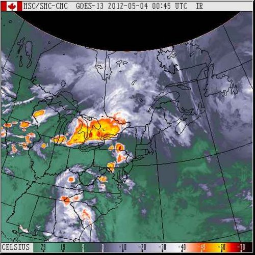
Across most of the Midwest yesterday, storms ranging between strong to severe rolled through the area resulting in 163 large hail reports and significant flooding in some places. The line of storms crossed Lake Huron into Southern Ontario and dumped a quick 76mm of rain on Orangeville, Ontario –where the average rainfall is usually 75mm for the month of May. This deluge resulted in flash flooding which caused over $1,000,000 in damages to businesses and properties while forcing over a dozen people to be evacuated from their houses.
Infrared satellite picture taken at 6:45pm showing numerous storms around the time Orangeville got hit by the storm that caused the flash flooding. The colder the cloud top, the stronger the storm. (Source: Environment Canada)
On Friday afternoon an interesting sight could be seen associated with a thunderstorm rolling across Orange City, Iowa: a haboob, also known as a dust storm, was spotted crossing the city limits as the thunderstorm arrived. The haboob is created when a downdraft of a thunderstorm is strong enough to pick up dust and sand ahead of the approaching storm. As the dust gets picked up, a haboob forms and a wall of dust can be seen reaching as high as a couple kilometers into the sky. When the thunderstorm weakens and there are no more downdrafts, the haboob will either just settle or will become a “mud storm” if there is still rain falling that will combine with the dust particles.
Picture of the haboob entering Orange City (Source: Reed Timmer/TVN)
The best storm dynamics will stay in the High Plains for the beginning of the weekend, slowly shifting south and east as the weekend rolls along.
Cooler weather has settled over Southern Manitoba and while it won’t stay below normal for long, we won’t really be hitting above normal temperatures any time soon, either. The week ahead looks like a middle-of-the-road week with some sun, some cloud, an a chance for some showers.
850mb Analysis of the θe field from the NAM, valid at 00Z Tuesday Evening
Today will bring clear skies to Winnipeg with diminishing winds. Our expected daytime high of 2°C will be a whopping 9°C below our normal daytime high of 11°C for this time of year. Tonight we’ll drop down to a chilly -7°C under clear skies.
Tomorrow will start off sunny and then cloud over in the afternoon as a low pressure system moves across Southern Manitoba. The main shortwave will track through the interlake, bringing in slightly warmer temperatures aloft across Southern Manitoba. The main surface low, however, will track just south of our border, keeping the warmer near-normal, temperatures to our south. Given that Southern Manitoba will have the southern low skirting just south of the International Border and be under the influence of large-scale ascent associated with the shortwave tracking further north, it looks quite likely that an area of showers will blossom as the system moves into Manitoba, and that regions along or just north of the Trans-Canada highway southwards to the U.S. Border will see showers on tomorrow afternoon. As ususal, the exact track will be key, however it’s fairly likely that most communities in the Red River Valley will see some showers tomorrow.
Shortwave vs. Surface Low? A shortwave is the term applied to a troughing disturbance in the upper atmosphere that travels along with the main flow aloft. A surface low is a low pressure system present in the lowest levels of the atmosphere. Each shortwave will often have a surface low pressure system associated with it and the two work in tandem to link the upper and lower atmospheres together. They are not co-located, however, and when compared on a map, can be hundreds of kilometers away from each other.
Things will clear out quickly tomorrow evening and then the rest of the week looks fairly benign, with daytime highs around 7°C and overnight lows around -5°C. Temperatures may jump back to normal on Friday with the approach a more significant low pressure system, but models disagree on it’s exact placement and some keep us on the cooler side of thigns; we’ll have more on that later in the week.
8-14 Day Temperature Anomoly Outlook from the NAEFS model from 12Z April 15, 2012.
Temperatures across the Eastern Prairies have been slightly below normal lately due to a persistant upper low anchored near Southampton Island in Hudson Bay. This low has maintained a trough and NW flow aloft over the Eastern Prairies and has been responsible for helping shunt systems further south and keeping us cooler. This large-scale pattern is expected to hold for the next 6-9 days, however signs are pointing to a breakdown of the low and a significant upper ridge to build across the Prairies in the Day 9-12 range. Ensemble models seem to agree with this idea, and as shown above, the NAEFS currently has fairly high confidence for a return to above-normal temperatures next week.
Elsewhere In Weather News
Tornado Alley Hit by Major Outbreak
The major tornado outbreak that occurred in the US Plains on Saturday, April 14th 2012 will be remembered for many years to come. Every single ingredient for long-tracked, damaging tornadoes was present. The storms developed due to a low pressure system centered over the Nebraska/Kansas border which drew in moist air from the gulf and into the Plains –- this spawned extremely strong supercells along its dryline as it slowly moved eastwards.
In anticipating major storms, the SPC had given plenty of warning to the affected areas, issuing a high risk in the 2-day outlook which is a very rare occurrence that has only happened once before. The high risk for tornadoes meant that within a 40km radius there was a 45% chance of an EF-2 to EF-5 tornado in parts of Nebraska and Kansas.
Probabalistic Tornado Graphic issued by the Storm Prediction Center on Saturday, April 14th.
Supercells had already exploded in the morning in the state of Kansas but did not produce any tornadoes until about 11:30am when a tornado had been spotted just north-east of North Platte, KS. From then on, tornado sightings were reported every 15 minutes until nightfall as just about every supercell from Nebraska to Oklahoma had a good chance of producing a tornado. Also to be kept in mind is that these supercells produce huge hail, reaching softball size (11.4cm in diameter), and cause significant damage to just about everything as they fall.
Violent tornado near Cherokee, OK
In all, around 100 tornadoes were sighted and luckily, many of them kept populated areas out of harm’s way as they missed villages and major cities. Unfortunately, there was one major city that had not been spared. The city of Woodward, OK (town of 12,000) was directly hit by a tornado, with a preliminary rating of EF-3. Five deaths and 29 injuries occurred in this city as the sirens did not go off, due to the tornado having cut their power. What aided the probability of injury and loss of life was also that the tornado had hit just after midnight, when most residents were asleep and it is extremely difficult to spot a tornado.
Some of the strongest tornadoes produced on Saturday – preliminary ratings:
EF-4 that just missed Salina, KS.
EF-3 that struck south-east Wichita, KS.
EF-3 that killed 5 in Woodward, OK.
EF-2 that damaged more than 75% of Creston, IA (town of 250).
Here are a couple of the many breath-taking photos/videos captured yesterday by storm chasers and those affected:
EF-4 tornado that just missed Salina, KS.
A large tree limb punched through the car’s side, product of the Wichita tornado. (Source: Cory Mottice)
Home moved off its foundation and destroyed in Wichita, KS.
Very powerful tornado north of Soloman, KS. (Source: AP)
Unfortunately the severe weather threat didn’t end there. More tornadoes were reported in the Upper Mississippi Valley on Sunday associated with the same system. As the system will race east on Monday, tornado probabilities are greatly reduced across the eastern half of the country however, severe thunderstorms are certainly not out of the question as cold air clashes with the warm air situated ahead of the system.
Southern Manitoba played host to almost all the different kinds of weather out there, with many locations seeing almost any combination of thunderstorms, hail, rain, drizzle, snow and blowing snow. A system that brought heavy snowfall to Western Manitoba and the Interlake region as well as thunderstorms and rain to the Red River Valley and Southeast Manitoba has trundled off into Ontario; we’re not out of the woods yet, though, as another system is set to quickly make it’s way into the province by tomorrow morning.
Photo of accumulated small hail at a downspout exit. Winnipeg was hit with hail from this size up to as large as dimes as a thunderstorm pushed through the city at around 2:30AM on Tuesday morning.
For today, we’ll see cloudy skies with a chance of a few remnant flurries this morning. We’ll see a daytime highs of only 2°C or 3°C through the RRV. Another low pressure system is already on it’s way to Manitoba, however, with the parent upper trough making landfall on the Oregon coast last night. This trough will advect eastwards and rotate northwards into the Central Prairies, bringing with it a warm front that will bisect the Prairies and slowly push eastwards.
This warm front is expected to push through the Winnipeg and the Red River Valley through the day on Thursday. Current indications are that we’ll be far enough south that we won’t have to worry about snow, that should be reserved for areas a bit further north in the Interlake region. We’ll see rain push in tomorrow morning around mid-morning and clear out by early evening. Rainfall totals currently look to be fairly uniform through the Red River Valley with totals around 10-15mm, however it does look like there’s a good chance for some enhanced convective areas which will result in fairly heavy showers interspersed through the general area of rain.We’ll enjoy warmer temperatures through the rest of the week, with the warm air pushing through bringing our daytime highs up to around 10°C.
We’re not out of the woods quite yet, though, as another low is forecast to track through the southern Interlake region bringing rain to areas along and north of the Trans-Canada Highway Friday night and Saturday morning. Current indications are that regions south of the Trans-Canada Highway will only see some scattered showers with this system.
NAEFS 8-14 Day Temperature Anomaly Outlook, valid for April 4 – April 11.
With a the passage of Tuesday’s weather system, North America has transitioned into a much different weather pattern that that which brought us our record-busting heat wave. With the blocking high collapsed over the SE United States, the summer-like heat will be contained further south in the Central and Southern Plains of the United States. Fortunately, the bitterly cold Arctic air that’s still omnipresent north of 60 will remain bottled up. So what does that mean for us? As the image above shows, ensemble forecasts are showing a moderate chance of above normal temperatures, however nothing nearly as certain as what was being predicted a couple weeks ago. The long-wave pattern has shifted to favor more frequent disturbances tracking through the Prairies, which should result in temperatures that may still be slightly above normal, but we’ll likely also see more precipitation than we had through much of March.
The stretch of dry weather Winnipeg has been experiencing over the past month should come to an end tonight as a significant low crosses across the Central Prairies.
Analysis of 20:45Z Satellite Imagery for August 7, 2011
A system that brought all sortsofsevereweather to Saskatchewan yesterday evening, including a potential tornado touchdown east of Regina, is pushing into Manitoba tonight and bringing with it the chance of severe weather for Southwestern Manitoba and much-needed rain to the Northern Red River Valley.
After battering residents of Saskatchewan from the Alberta border all the way to the southeast corner of the province, the main driving force for the entire system began to slowly move eastwards last night. As it pushes through Saskatchewan, the favourable conditions that existed through much of Saskatchewan have been pushed eastwards to eastern SK and much of southwestern Manitoba.
Watches in effect for Manitoba at 4:50PM local time.
Weather watches are out for severe thunderstorms through much of southwest and Parkland Manitoba. Thunderstorms will continue to develop into the evening and as the low pressure system and associated trough line move into the area, many have the potential to become severe with the main threats being large hail through Minnedosa and Dauphin, and the slight chance of a tornado in addition to heavy rains and large hail through southwest Manitoba.
6hr. QPF from the 12Z Aug 7 run of the GFS model valid for 09Z Aug 8 (~4AM local)
Winnipeg and the RRV will have a slight chance of some showers this evening (with the off chance of a lightning strike or two), however the extremely dry low-levels, with dew points only around 11°C, will make it unlikely that any cells that move into our area will actually be able produce rain that makes it to the surface. However, by 9 or 10PM tonight, the low and trough begin to enter the RRV and a large area of rain with isolated embedded thunderstorms will develop, resulting in a large north-south band of rain that will pass over the RRV tonight. Most areas will see 5-10mm of the wet stuff with a slight chance of 15-20mm in areas that see a thunderstorm tonight. I think that the risk for severe weather will stay in the southwest portion of the province today; overnight we should just see rain and a slight chance of a light show.
Monday will be one of the most significantly different days we’ve had over the past month. On the back side of this low, cooler air dives down from the northern Prairies. Much of the Southern Prairies will see highs of only 18-22°C with brisk northwest winds gusting to 50km/h, which will make it feel downright cool relative to the last couple weeks. Here in the Red River Valley, we also have a good chance of showers moving down from the interlake into the area by the early afternoon.
After our damp, windy, cool Monday, things improve through Tuesday and we’ll be back into the high 20’s by Wednesday. More rain may be in store for the later half of the week, but more on that later.
I, for one, welcome a nice rainy night. So does my lawn…